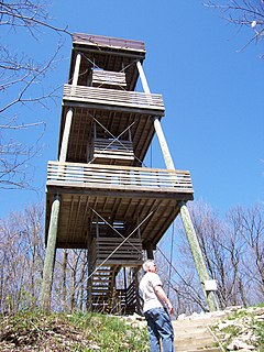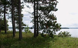
Afton State Park is a state park of Minnesota, USA, on the St. Croix River in Washington County. Its hiking trails offer views of the river, rolling glacial moraine, and bluffland it preserves. It is a popular place for birdwatching, picnics, camping, and other typical outdoor recreational activities. To deter overuse of a state park only 20 miles (32 km) from downtown St. Paul, there is no vehicle access to the camping area or swimming beach.

Chippewa National Forest is a National Forest located in north central Minnesota, United States, in the counties of Itasca, Cass and Beltrami. Forest headquarters are located in Cass Lake, Minnesota. There are local ranger district offices in Blackduck, Deer River and Walker.

The North Shore of Lake Superior runs from Duluth, Minnesota, United States, at the southwestern end of the lake, to Thunder Bay and Nipigon, Ontario, Canada, in the north to Sault Ste. Marie, Ontario, in the east. The shore is characterized by alternating rocky cliffs and cobblestone beaches, with forested hills and ridges through which scenic rivers and waterfalls descend as they flow to Lake Superior.

Interstate Park comprises two adjacent state parks on the Minnesota–Wisconsin border, both named Interstate State Park. They straddle the Dalles of the St. Croix River, a deep basalt gorge with glacial potholes and other rock formations. The Wisconsin park is 1,330 acres (538 ha) and the Minnesota park is 298 acres (121 ha). The towns of Taylors Falls, Minnesota and St. Croix Falls, Wisconsin are adjacent to the park. Interstate Park is within the Saint Croix National Scenic Riverway and the Ice Age National Scientific Reserve. The western terminus of the Ice Age National Scenic Trail is on the Wisconsin side. On the Minnesota side, two areas contain National Park Service rustic style buildings and structures that are listed on the National Register of Historic Places.

Jay Cooke State Park is a state park of Minnesota, United States, protecting the lower reaches of the Saint Louis River. The park is located about 10 miles (16 km) southwest of Duluth and is one of the ten most visited state parks in Minnesota. The western half of the park contains part of a rocky, 13-mile (21 km) gorge. This was a major barrier to Native Americans and early Europeans traveling by canoe, which they bypassed with the challenging Grand Portage of the St. Louis River. The river was a vital link connecting the Mississippi waterways to the west with the Great Lakes to the east.

St. Croix State Park is a state park in Pine County, Minnesota, USA. The park follows the shore of the St. Croix River for 21 miles (34 km) and contains the last 7 miles (11 km) of the Kettle River. At 33,895 acres (13,717 ha) it is the largest Minnesota state park. It was developed as a Recreational Demonstration Area in the 1930s, and is one of the finest surviving properties of this type in the nation. 164 structures built by the Civilian Conservation Corps and the Works Progress Administration survive, the largest collection of New Deal projects in Minnesota. As a historic district they were listed on the National Register of Historic Places and proclaimed a National Historic Landmark in 1997.

The Kettle Moraine State Forest is a state forest in southeastern Wisconsin. The chief feature of the reserve is the Kettle Moraine, a highly glaciated area. The area contains very hilly terrain and glacial landforms, such as kettles, kames and eskers. The 56,000-acre (23,000 ha) forest is divided into two large and three small units, which are spread across a hundred miles.

Lake Wissota State Park is a 1,062-acre (430 ha) Wisconsin state park near the town of Chippewa Falls. The park is situated on the northeast shore of Lake Wissota, a reservoir on the Chippewa River. Camping, boating, and fishing are the most popular activities. Park lands are covered in a mix of pine/hardwood forests and prairie. Visitors can access the Old Abe State Trail and bike or hike 17.5 miles (28.2 km) to Brunet Island State Park.

Brunet Island State Park is a state park of Wisconsin, USA, featuring a 169-acre (68 ha) island in the Chippewa River. The remainder of the park's 1,225 acres (496 ha) are on the east bank of the river. It is noted for its numerous white-tailed deer and large eastern hemlock trees. The park is located just north of Cornell in Chippewa County in the Northern Highland region of Wisconsin. The Old Abe State Trail begins in the park and follows the riverbank south to the town of Chippewa Falls, with access to Lake Wissota State Park.

Ravensburg State Park is a Pennsylvania state park in Crawford Township in Clinton County, Pennsylvania in the United States. It is in a gorge carved by Rauchtown Run through the side of Nippenose Mountain. Ravensburg State Park is 78 acres (32 ha) of wooded land that is almost entirely surrounded by Tiadaghton State Forest. This state park is on Pennsylvania Route 880, 8 miles (13 km) north of Carroll and 8 miles (13 km) south-east of Jersey Shore. The nearest city is Williamsport.

Leonard Harrison State Park is a 585-acre (237 ha) Pennsylvania state park in Tioga County, Pennsylvania, in the United States. It is on the east rim of the Pine Creek Gorge, also known as the Grand Canyon of Pennsylvania, which is 800 feet (240 m) deep and nearly 4,000 feet (1,200 m) across here. It also serves as headquarters for the adjoining Colton Point State Park, its sister park on the west rim of the gorge. Leonard Harrison State Park is known for its views of the Pine Creek Gorge, and offers hiking, fishing and hunting, whitewater boating, and camping. The park is in Shippen and Delmar Townships, 10 miles (16 km) west of Wellsboro at the western terminus of Pennsylvania Route 660.

Hyner Run State Park is a 180-acre (73 ha) Pennsylvania state park in Chapman Township, Clinton County, Pennsylvania in the United States. The park is 6 miles (9.7 km) east of Renovo and 3 miles (5 km) north of Hyner on Pennsylvania Route 120. Hyner Run State Park is surrounded by Sproul State Forest.

White Pines Forest State Park, more commonly referred to as White Pines State Park, is an Illinois state park in Ogle County, Illinois. It is located near the communities of Polo, Mount Morris and Oregon. The 385-acre (156 ha) park contains the southernmost remaining stand of native white pine trees in the state of Illinois, and that area, 43 acres (17 ha), was designated an Illinois Nature Preserve in 2001.

Kooser State Park is a 250-acre (101 ha) Pennsylvania state park in Jefferson Township, Somerset County, Pennsylvania, in the United States. The park, which borders Forbes State Forest, was built in the 1930s by the Civilian Conservation Corps, who also built the 4-acre (1.6 ha) Kooser Lake by damming Kooser Run. Kooser State Park is on Pennsylvania Route 31 a one-hour drive from Pittsburgh. The park is surrounded by Forbes State Forest.

Copper Falls State Park is a 3,068-acre (1,242 ha) state park in Wisconsin. The park contains a section of the Bad River and its tributary the Tylers Forks, which flow through a gorge and drop over several waterfalls. Old Copper Culture Indians and later European settlers mined copper in the area. The state park was created in 1929 and amenities were developed by the Civilian Conservation Corps and the Works Progress Administration. In 2005 the park was listed on the National Register of Historic Places as a site with 10 contributing properties.

Spencer State Forest is a Massachusetts state forest and recreation reserve located in the town of Spencer, managed by the Massachusetts Department of Conservation and Recreation. The 92 mile (148 km) Midstate Trail passes through the state forest. The Commonwealth of Massachusetts also conducts logging in some parts of the property.
The Taconite State Trail extends 165 miles from Grand Rapids, Minnesota to Ely, Minnesota and intersects the Arrowhead State Trail west of Lake Vermilion. On the Grand Rapids end, the trail is paved for the first 6 miles for in-line skating and biking. The rest of the trail is natural surface used primarily in the winter months for snowmobiling. In the summer, several areas contain standing water, but some areas are suitable for horseback riding, hiking, and mountain biking

The Grand Portage State Forest is a state forest located near the community of Hovland in Cook County, in extreme northeastern Minnesota. The forest encloses Judge C. R. Magney State Park, Swamp River Wildlife Management Area, Hovland Woods Scientific and Natural Area, and Spring Beauty Hardwoods Scientific and Natural Area. It borders the Grand Portage Indian Reservation to the east, the Superior National Forest to the west, and Ontario to the north. The forest is named after the Grand Portage, a historic trade route between the Great Lakes and the Northwest.
The Hill River State Forest is a state forest located in Aitkin County, Minnesota. It borders the Savanna State Forest to the east, and the Chippewa National Forest and the Land O'Lakes State Forest to the west. The majority of the forest is managed by the Minnesota Department of Natural Resources.
The Paul Bunyan State Forest is a state forest located in Hubbard and Cass counties in Minnesota. The forest borders the Chippewa National Forest and the Welsh Lake State Forest to the east, and the Mississippi Headwaters State Forest to the northwest. The forest is managed by the Minnesota Department of Natural Resources and the land department for Hubbard County.


