
The Kalamazoo River is a river in the U.S. state of Michigan. The river is 130 miles (210 km) long from the junction of its North and South branches to its mouth at Lake Michigan, with a total length extending to 178 miles (286 km) when one includes the South Branch. The river's watershed drains an area of approximately 2,020 square miles (5,200 km2) and drains portions of eight counties in southwest Michigan: Allegan, Barry, Eaton, Van Buren, Kalamazoo, Calhoun, Jackson, Hillsdale, Kent and Ottawa. The river has a median flow of 1,863 cubic feet per second (52.8 m3/s) at New Richmond, upstream from its mouth at Saugatuck.

The Laurentian Mixed Forest Province, also known as the North Woods, is a forested ecoregion in eastern North America. Among others, this terminology has been adopted by the Minnesota Department of Natural Resources. Similar, though not necessarily entirely identical regions, are identified by the United States Environmental Protection Agency as Northern Lakes and Forests, and by the World Wildlife Fund by regions such as the Western Great Lakes forests and Eastern forest-boreal transition.
The Enbridge Pipeline System is an oil pipeline system which transports crude oil and dilbit from Canada to the United States. The system exceeds 5,000 kilometres (3,100 mi) in length including multiple paths. More than 3,000 kilometres (1,900 mi) of the system is in the United States while the rest is in Canada and serves the Athabasca oil sands production facilities. Main parts of the system are 2,306-kilometre-long (1,433 mi) Canadian Mainline and 3,057-kilometre-long (1,900 mi) Lakehead System. On average, it delivers 1.4 million barrels per day of crude oil and other products to the major oil refineries in the American Midwest and the Canadian province of Ontario. The Canadian portion is owned by Enbridge, while the U.S. portion is partly owned by that company through Enbridge Energy Partners, LP, formerly known as Lakehead Pipe Line Partners and Lakehead Pipe Line Company.
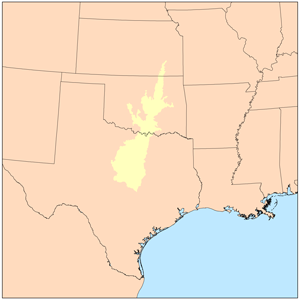
The term Cross Timbers, also known as Ecoregion 29, Central Oklahoma/Texas Plains, is used to describe a strip of land in the United States that runs from southeastern Kansas across Central Oklahoma to Central Texas. Made up of a mix of prairie, savanna, and woodland, it forms part of the boundary between the more heavily forested eastern country and the almost treeless Great Plains, and also marks the western habitat limit of many mammals and insects.

The Columbia Plateau ecoregion is a Level III ecoregion designated by the United States Environmental Protection Agency (EPA) encompassing approximately 32,100 square miles (83,139 km2) of land within the U.S. states of Washington, Oregon, and Idaho. The ecoregion extends across a wide swath of the Columbia River Basin from The Dalles, Oregon to Lewiston, Idaho to Okanogan, Washington near the Canada–US border. It includes nearly 500 miles (800 km) of the Columbia River, as well as the lower reaches of major tributaries such as the Snake and Yakima rivers and the associated drainage basins. It is named for the Columbia River Plateau, a flood basalt plateau formed by the Columbia River Basalt Group during the late Miocene and early Pliocene. The arid sagebrush steppe and grasslands of the region are flanked by moister, predominantly forested, mountainous ecoregions on all sides. The underlying basalt is up to 2 miles (3 km) thick and partially covered by thick loess deposits. Where precipitation amounts are sufficient, the deep loess soils have been extensively cultivated for wheat. Water from the Columbia River is subject to resource allocation debates involving fisheries, navigation, hydropower, recreation, and irrigation, and the Columbia Basin Project has dramatically converted much of the region to agricultural use.

The Great Basin montane forests is an ecoregion of the Temperate coniferous forests biome, as designated by the World Wildlife Fund (WWF).

The Western Great Lakes forests is a terrestrial ecoregion as defined by the World Wildlife Fund. It is within the temperate broadleaf and mixed forests biome of North America. It is found in northern areas of the United States' states of Michigan, Wisconsin and Minnesota, and southern areas of the Canadian provinces of Ontario and Manitoba.

The Mississippi Alluvial Plain is a Level III ecoregion designated by the Environmental Protection Agency (EPA) in seven U.S. states, though predominantly in Arkansas, Louisiana, and Mississippi. It parallels the Mississippi River from the Midwestern United States to the Gulf of Mexico.

The North Central Hardwood Forests are a temperate broadleaf and mixed forests ecoregion in central Minnesota, central Wisconsin, and northwestern Lower Michigan, embedded between (clockwise) the Western Corn Belt Plains in the south, the Northern Glaciated Plains, the Red River Valley, the Northern Minnesota Wetlands, and the Northern Lakes and Forests. It forms the northern part of the upper Midwest forest-savanna transition, which also includes regions 52 and 53.

The Arkansas Valley is a Level III ecoregion designated by the Environmental Protection Agency (EPA) in the U.S. states of Arkansas and Oklahoma. It parallels the Arkansas River between the flat plains of western Oklahoma and the Arkansas Delta, dividing the Ozarks and the Ouachita Mountains with the broad valleys created by the river's floodplain, occasionally interrupted by low hills, scattered ridges, and mountains. In Arkansas, the region is often known as the Arkansas River Valley, especially when describing the history and culture of the region.
The Southeastern Wisconsin Till Plains is an ecoregion in southeastern Wisconsin and northeastern Illinois in the United States. It is a Level III ecoregion in the classification system of the United States Environmental Protection Agency (EPA), where it is designated as ecoregion number 53. The ecoregion represents a transition between the hardwood forests and oak savannas to the west and the tallgrass prairie ecoregions to the south; it is today mostly covered by cropland.

The Western Corn Belt Plains is a Level III ecoregion designated by the Environmental Protection Agency (EPA) in seven U.S. states, though predominantly in Iowa.
