
Renville County is a county in the U.S. state of Minnesota. As of the 2020 census the population was 14,723. Its county seat is Olivia.

Brown County is a county in the U.S. state of Minnesota. As of the 2020 census, the population was 25,912. Its county seat is New Ulm. The county was formed in 1855 and organized in 1856.

Browns Valley is a city in Traverse County, Minnesota, United States, adjacent to the South Dakota border. The population was 558 at the 2020 census.

The Wayside is a historic house in Concord, Massachusetts. The earliest part of the home may date to 1717. Later it successively became the home of the young Louisa May Alcott and her family, who named it Hillside, author Nathaniel Hawthorne and his family, and children's writer Margaret Sidney. It became the first site with literary associations acquired by the National Park Service and is now open to the public as part of Minute Man National Historical Park.

This is a list of sites in Minnesota which are included in the National Register of Historic Places. There are more than 1,700 properties and historic districts listed on the NRHP; each of Minnesota's 87 counties has at least 2 listings. Twenty-two sites are also National Historic Landmarks.

The St. Croix Boom Site is a historic and scenic wayside on the St. Croix River in Stillwater Township, Minnesota, United States. It commemorates the location of a critical log boom where, from 1856 to 1914, timber from upriver was sorted and stored before being dispatched to sawmills downstream. The site was developed as a roadside park along Minnesota State Highway 95 in the 1930s. In 1966 it was designated a National Historic Landmark for its national significance in the theme of industry. It was nominated for being the earliest, most important, and longest serving of the log storage and handling operations that supported Minnesota's major logging industry. Virtually no traces remain of the site's original buildings and structures.
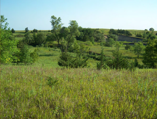
The Battle of Wood Lake occurred on September 23, 1862, and was the final battle in the Dakota War of 1862. The two-hour battle, which actually took place at nearby Lone Tree Lake, was a decisive victory for the U.S. forces led by Colonel Henry Hastings Sibley. With heavy casualties inflicted on the Dakota forces led by Chief Little Crow, the "hostile" Dakota warriors dispersed. Little Crow and 150 followers fled for the northern plains, while other Mdewakantons quietly joined the "friendly" Dakota camp started by the Sisseton and Wahpeton bands, which would soon become known as Camp Release.

The Battle of Birch Coulee occurred September 2–3, 1862 and resulted in the heaviest casualties suffered by U.S. forces during the Dakota War of 1862. The battle occurred after a group of Dakota warriors followed a U.S. burial expedition, including volunteer infantry, mounted guards and civilians, to an exposed plain where they were setting up camp. That night, 200 Dakota soldiers surrounded the camp and ambushed the Birch Coulee campsite in the early morning, commencing a siege that lasted for over 30 hours, until the arrival of reinforcements and artillery led by Colonel Henry Hastings Sibley.
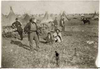
The Surrender at Camp Release was the final act in the Dakota War of 1862. After the Battle of Wood Lake, Colonel Henry Hastings Sibley had considered pursuing the retreating Sioux, but he realized he did not have the resources for a vigorous pursuit. Furthermore, he was aware that Chief Little Crow had been losing support and was in contact with several Mdewakanton chiefs who had signaled their opposition to further conflict.

Joseph Renville (1779–1846) was an interpreter, translator, expedition guide, Canadian officer in the War of 1812, founder of the Columbia Fur Company, and an important figure in dealings between settlers of European ancestry and Dakota (Sioux) Natives in Minnesota. He contributed to the translation of Christian religious texts into the Dakota language. The hymnal Dakota dowanpi kin, was "composed by J. Renville and sons, and the missionaries of the A.B.C.F.M." and was published in Boston in 1842. Its successor, Dakota Odowan, first published with music in 1879, has been reprinted many times and is in use today.
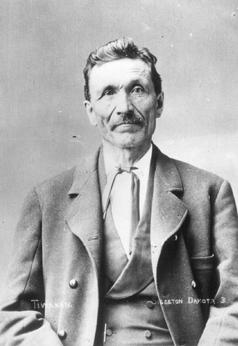
Gabriel Renville, also known as Ti'wakan, was Chief of the Sisseton Wahpeton Oyate Sioux Tribe from 1866 until his death in 1892. He opposed conflict with the United States during the Dakota War of 1862 and was a driving force within the Dakota Peace Party. Gabrielle Renville's influence and political leadership were critical to the eventual creation of the Lake Traverse Indian Reservation, which lies mainly in present-day South Dakota.

Joseph Renshaw Brown (1805–1870) was an American politician, pioneer, fur trader, newspaper editor, businessman, inventor, speculator, and Indian agent who was prominent in Minnesota and Wisconsin territorial and state politics for over 50 years.
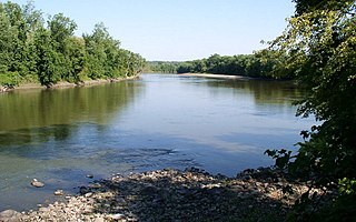
Traverse des Sioux is a historic site in the U.S. state of Minnesota. Once part of a pre-industrial trade route, it is preserved to commemorate that route, a busy river crossing on it, and a nineteenth-century settlement, trading post, and mission at that crossing place. It was a transshipment point for pelts in fur trading days, and the namesake for an important United States treaty that forced the Dakota people to cede part of their homeland and opened up much of southern Minnesota to European-American settlement.

Birch Coulee Battlefield in Renville County, Minnesota, United States, was the site of the Battle of Birch Coulee, the costliest military engagement for U.S. forces during the Dakota War of 1862. It is now a historic site with self-guided trails and markers interpreting the battle from both sides. Birch Coulee was nominated to the National Register of Historic Places for having state-level significance in military history, and was listed in 1973.

The Banfill Tavern, also known as the Locke House, is a historic building in Fridley, Minnesota, United States. It was built in 1847 on the east bank of the Mississippi River and has served variously as an inn, a logging camp office, a private home, a dairy farm, a post office, and a summer home. It is now owned by Anoka County and, until April 2022, housed the non-profit Banfill-Locke Center for the Arts. The building stands within Manomin County Park, and the art center is a partner site of the Mississippi National River and Recreation Area.
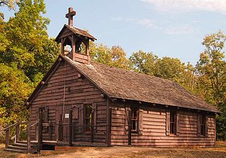
Lac qui Parle Mission is a pre-territorial mission in Chippewa County, Minnesota, United States, which was founded in June 1835 by Dr. Thomas Smith Williamson and Alexander Huggins after fur trader Joseph Renville invited missionaries to the area. Lac qui Parle is a French translation of the native Dakota name, meaning "lake which speaks". In the 19th century, the first dictionary of the Dakota language was written, and part of the Bible was translated into that language for the first time at a mission on the site of the park. It was a site for Christian missionary work to the Sioux for nearly 20 years. Renville was related to and had many friends in the Native community, and after his death in 1846, the mission was taken over by the "irreligious" Martin McLeod. The relationship between the mission and the Dakota people worsened, and in 1854 the missionaries abandoned the site and relocated to the Upper Sioux Agency.

The Craigie Flour Mill Historical Marker is a wayside rest on Minnesota State Highway 78 in Otter Tail County, Minnesota. The site was designed by landscape architect Arthur R. Nichols and built by the National Youth Administration and the Minnesota Highway Department. The style is National Park Service Rustic architecture.

Sam Brown Memorial State Wayside is a historical park in Browns Valley, Minnesota, United States, established in 1929 to honor frontiersman Sam Brown (1845–1925). On April 19, 1866, Brown rode 55 miles (89 km) to warn other settlers of an impending attack by Native Americans, and when the threat proved false he rode back through a spring blizzard to intercept his dispatch to the U.S. Army, suffering injuries that left him in a wheelchair for the rest of his life.
Leesylvania was a plantation and historic home in Prince William County, Virginia, now part of Leesylvania State Park. During the 18th century, it was the home of Henry Lee II, his family and numerous slaves, and known for its productive land and especially the quality of its tobacco. Lee's sons Henry "Light-Horse Harry" Lee, Richard Bland Lee and Charles Lee, held prominent positions in Virginia during the American Revolutionary War and early federal government.

The Henderson Community Building, also known as the Old Sibley County Courthouse, is a historic government building in Henderson, Minnesota, United States. It was built in 1879 and served as the home of Sibley County's government until 1915, when the county seat was relocated to Gaylord, Minnesota.


