
Grand Forks County is a county in the U.S. state of North Dakota. As of the 2020 census, its population was 73,170, making it the third-most populous county in North Dakota. Its county seat and largest community is Grand Forks.

Polk County is a county in the northwestern part of the U.S. state of Minnesota. The population was 31,192 at the 2020 census. Its county seat is Crookston, and the largest community is East Grand Forks.

East Grand Forks is a city in Polk County, Minnesota, United States. The population was 9,176 at the 2020 Census, making it the largest community in Polk County.

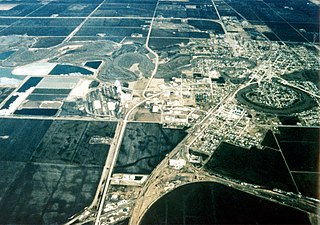
Grand Forks is the third-largest city in the state of North Dakota and the county seat of Grand Forks County. According to the 2020 census, the city's population was 59,166. Grand Forks, along with its twin city of East Grand Forks, Minnesota, forms the center of the Grand Forks, ND-MN Metropolitan Statistical Area, which is often called Greater Grand Forks or the Grand Cities.
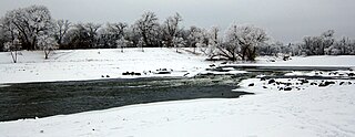
The Red River is a river in the north-central United States and central Canada. Originating at the confluence of the Bois de Sioux and Otter Tail rivers between the U.S. states of Minnesota and North Dakota, it flows northward through the Red River Valley, forming most of the border of Minnesota and North Dakota and continuing into Manitoba. It empties into Lake Winnipeg, whose waters join the Nelson River and ultimately flow into Hudson Bay.

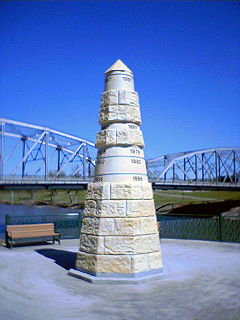
The Red River flood of 1997 was a major flood that occurred in April and May 1997 along the Red River of the North in Minnesota, North Dakota, and Southern Manitoba. It was the most severe flood of the river since 1826. The flood reached throughout the Red River Valley, affecting the cities of Fargo and Winnipeg, but none so greatly as Grand Forks and East Grand Forks, where floodwaters reached more than 3 miles (4.8 km) inland. They inundated virtually everything in the twin communities. Total damages for the Red River region were US$3.5 billion. The flood was the result of abundant snowfall and extreme temperatures.
The Red Lake River is a river located in northwestern Minnesota. The river begins on the western side of the Lower Red Lake and flows westward. After passing through Thief River Falls, Red Lake Falls, and Crookston, the river merges with the Red River of the North in East Grand Forks. The total length of the river is 193 miles (311 km) The term "Forks" in Grand Forks comes from this forking (confluence) of the Red and Red Lake rivers near downtown Grand Forks.
The Greater Grand Forks Greenway is a huge greenway bordering the Red River and Red Lake River in the twin cities of Grand Forks, North Dakota and East Grand Forks, Minnesota. At 2,200 acres (9 km2), the Greenway is more than twice the size of New York City's Central Park. It has an extensive, 20-mile (32 km) system of bike paths, which are used by bikers, walkers, joggers, and rollerbladers. In 2007, the system was designated as a National Recreation Trail by the National Park Service.

Big Bog State Recreation Area, a recent addition to the Minnesota state park system, is located on Minnesota State Highway 72, north of Waskish, Minnesota. It covers 9,459 acres (38.3 km2), primarily swamps, bogs, and upland "islands".

South Fork State Recreation Area is a state park unit of the state of Nevada covering nearly four thousand acres, located five miles (8.0 km) due south of Elko. The park comprises the 1,650-acre (670 ha) South Fork Reservoir and surrounding marsh, meadowlands, and hills.

Minnesota State Highway 220 is a 78.536-mile-long (126.391 km) regional trunk highway in northwest Minnesota, which runs from its intersection with U.S. Highway 75 in Climax and continues north to its northern terminus at its intersection with MN 11 near Drayton, North Dakota. The route runs along and near the Red River.

The U.S. State of Minnesota is the northernmost state outside Alaska; its isolated Northwest Angle in Lake of the Woods is the only part of the 48 contiguous states lying north of the 49th parallel north. Minnesota is in the U.S. region known as the Upper Midwest in interior North America. The state shares a Lake Superior water border with Michigan and Wisconsin on the northeast; the remainder of the eastern border is with Wisconsin. Iowa is to the south, North Dakota and South Dakota are to the west, and the Canadian provinces of Ontario and Manitoba are to the north. With 87,014 square miles (225,370 km2), or approximately 2.26% of the United States, Minnesota is the 12th largest state.
The Red River flood of 1997 in the United States was a major flood that occurred in April 1997, along the Red River of the North in North Dakota and Minnesota. The flood reached throughout the Red River Valley, affecting the cities of Fargo, Moorhead, and Winnipeg, while Grand Forks and East Grand Forks received the most damage, where floodwaters reached over 3 miles (5 km) inland, inundating virtually everything in the twin communities. Total damages for the Red River region were US$3.5 billion.
The Beltrami Island State Forest is a state forest located in Lake of the Woods, Roseau, and Beltrami counties, Minnesota. Named after Italian explorer Giacomo Beltrami, it is the second-largest state forest in the Minnesota system after Pine Island State Forest. The largest wildlife management area in the state at 321,149 acres (129,964 ha), the Red Lake Wildlife Management Area, is located within the forest. The majority of the forest is managed by the Minnesota Department of Natural Resources, although a significant portion are tribal lands belonging to the neighboring Red Lake Band of Ojibwe.
The Big Fork State Forest is a state forest located in Koochiching and Itasca counties, Minnesota. It is primarily managed by the Minnesota Department of Natural Resources. The landscape has many moraines, lakes, and wetlands. The "Lost 40" and the largest red pine in the state of Minnesota are located within the forest.

The Grand Portage State Forest is a state forest located near the community of Hovland in Cook County, in extreme northeastern Minnesota. The forest encloses Judge C. R. Magney State Park, Swamp River Wildlife Management Area, Hovland Woods Scientific and Natural Area, and Spring Beauty Hardwoods Scientific and Natural Area. It borders the Grand Portage Indian Reservation to the east, the Superior National Forest to the west, and Ontario to the north. The forest is named after the Grand Portage, a historic trade route between the Great Lakes and the Northwest.
The Hill River State Forest is a state forest located in Aitkin County, Minnesota. It borders the Savanna State Forest to the east, and the Chippewa National Forest and the Land O'Lakes State Forest to the west. The majority of the forest is managed by the Minnesota Department of Natural Resources.

Greenleaf Lake State Recreation Area is a state park unit of Minnesota, USA, currently in development. It includes undeveloped shoreline on both Greenleaf and Sioux Lakes, halfway between the cities of Hutchinson and Litchfield in Meeker County. Portions of the state recreation area (SRA) are open to the public for day-use recreation, but there are no facilities yet on site. The park boundaries were set by the Minnesota Legislature and the state is still acquiring land from willing sellers; two-thirds of the property remain privately owned.


