Grand Portage State Forest

Last updated
Grand Portage State Forest
USA Minnesota location map.svg
Red pog.svg
Geography
Location Cook County, Minnesota, United States
Coordinates 47°56′07″N89°56′35″W / 47.9351665°N 89.9431483°W / 47.9351665; -89.9431483 Coordinates: 47°56′07″N89°56′35″W / 47.9351665°N 89.9431483°W / 47.9351665; -89.9431483
Elevation1,378 feet (420 m)
Area99,200 acres (40,100 ha)
Administration
Established1933
Governing body Minnesota DNR, USFS, private
Website www.dnr.state.mn.us/state_forests/sft00023/index.html
Ecology
WWF Classification Western Great Lakes Forests
EPA Classification Northern Lakes and Forests
Disturbance Wildfire
Map of the Grand Portage State Forest Grandportage sf.jpg
Map of the Grand Portage State Forest

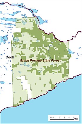
The Grand Portage State Forest is a state forest located near the community of Hovland in Cook County, in extreme northeastern Minnesota. The forest encloses Judge C. R. Magney State Park, Swamp River Wildlife Management Area, Hovland Woods Scientific and Natural Area, and Spring Beauty Hardwoods Scientific and Natural Area. It borders the Grand Portage Indian Reservation to the east, the Superior National Forest to the west, and Ontario to the north. The forest is named after the Grand Portage, a historic trade route between the Great Lakes and the Northwest.

Contents

History

The area was extensively logged in the early 20th century, and abandoned logging camps can still be found throughout the forest. The Pigeon River Company, the Hughes Brothers Timber Company, and the George W. Mead Company were responsible for the harvest of millions of board feet of White Pine and Northern White Cedar timber, and pulpwood from the black and white spruce found in the forest. Cut pulpwood was usually rafted on Lake Superior to pulp mills in Wisconsin. Wildfires historically played a large part in the formation of the forest's woods. In 1910, a wildfire burned through much of the southeast portion of the forest, and in 1936, 10,000 acres (4,000 ha) of the central part of the forest were burned.

The state forest was established in 1933. [1] By June of that year, passage of the Emergency Conservation Work Act and creation of the Civilian Conservation Corps led to establishment of CCC Camp S-62 in Hovland by Company 722. For the next four years, under the direct of State Forest Service personnel, the company planted trees, fought wildfires, and built roads, fire towers, buildings, and recreational facilities on the forest.

Recreation

Located in the Arrowhead Region of the state, the forest has a number of regional trails. The Border Route Trail follows the Pigeon River, which is the northern limit of the forest and forms the international border between the United States and Canada. This trail connects with the Superior Hiking Trail in the northeastern portion of the forest.

The abundance of lakes in the forest make fishing and water recreation very popular. There are nine boat launches in the forest, including one at McFarland Lake in the northernmost area of the forest, which serves as the easternmost entrance to the Boundary Waters Canoe Area Wilderness. Other outdoor recreational activities include picnicking; 30 miles (48 km) of designated hiking trails, 40 miles (64 km) for snowmobiling, and over 60 miles (97 km) for cross-country skiing. Backcountry camping is offered as an alternative to camping at the three established campgrounds. [2]

See also

Related Research Articles

Cook County, Minnesota County in Minnesota, United States

Cook County is a county in the U.S. state of Minnesota. As of the 2020 United States Census, the population was 5,600, making it Minnesota's seventh-least populous county. Its county seat is Grand Marais. The Grand Portage Indian Reservation is in the county.

Pigeon River (Minnesota–Ontario)

The Pigeon River forms part of the Canada–United States border between the state of Minnesota and the province of Ontario, west of Lake Superior. In pre-industrial times the river was a waterway of great importance for transportation and the fur trade.

Boundary Waters Canoe Area Wilderness Wilderness area in Minnesota, United States

The Boundary Waters Canoe Area Wilderness is a 1,090,000-acre (4,400 km2) wilderness area within the Superior National Forest in northeastern part of the US state of Minnesota under the administration of the U.S. Forest Service. A mixture of forests, glacial lakes, and streams, the BWCAW's preservation as a primitive wilderness began in the 1900s and culminated in the Boundary Waters Canoe Area Wilderness Act of 1978. It is a popular destination for canoeing, hiking, and fishing, and is one of the most visited wildernesses in the United States.

Minnesota State Highway 61 is a 148.843-mile-long (239.540 km) highway in northeast Minnesota, which runs from a junction with Interstate 35 (I-35) in Duluth at 26th Avenue East, and continues northeast to its northern terminus at the Canadian border near Grand Portage, connecting to Ontario Highway 61 at the Pigeon River Bridge. The route is a scenic highway, following the North Shore of Lake Superior, and is part of the Lake Superior Circle Tour designation that runs through Minnesota, Ontario, Michigan, and Wisconsin.

Canoe camping

Canoe camping, also known as touring, tripping or expedition canoeing, is a combination of canoeing and camping. Like backpacking, canoe campers carry enough with them to travel and camp for several days, but do so via a canoe or kayak.

County State-Aid Highway 12 (Cook County, Minnesota) Highway in Minnesota

County State-Aid Highway 12 (CSAH 12), also known as the Gunflint Trail, or County Road 12 (CR 12), is a 57-mile (92 km) paved roadway and National Scenic Byway in Cook County, Minnesota, that begins in Grand Marais and ends at Saganaga Lake in the Boundary Waters Canoe Area Wilderness (BWCAW), near the U.S. border with Ontario. It provides access to many of the entry points in the BWCAW.

Arrowhead Region

The Arrowhead Region is located in the northeastern part of the U.S. state of Minnesota, so called because of its pointed shape. The predominantly rural region encompasses 10,635.26 square miles (27,545.2 km2) of land area and includes Carlton, Cook, Lake and Saint Louis counties. Its population at the 2000 census was 248,425 residents. The region is loosely defined, and Aitkin, Itasca, and Koochiching counties are sometimes considered as part of the region, increasing the land area to 18,221.97 square miles (47,194.7 km2) and the population to 322,073 residents. Primary industries in the region include tourism and iron mining.

Savanna Portage State Park United States historic place

Savanna Portage State Park is a state park of Minnesota, USA, established in 1961 to preserve the historic Savanna Portage, a difficult 6-mile (9.7 km) trail connecting the watersheds of the Mississippi River and Lake Superior. The portage trail crosses a drainage divide separating the West Savanna River, which drains to the Mississippi River and the Gulf of Mexico, from the East Savanna River, which flows in an opposite direction to the Saint Louis River, Lake Superior and the Great Lakes, and the Saint Lawrence River to the Atlantic Ocean.

Grand Portage National Monument United States historic place

Grand Portage National Monument is a United States National Monument located on the north shore of Lake Superior in northeastern Minnesota that preserves a vital center of fur trade activity and Anishinaabeg Ojibwe heritage. The area became one of the British Empire's four main fur trading centers in North America, along with Fort Niagara, Fort Detroit, and Michilimackinac.

North Shore (Lake Superior)

The North Shore of Lake Superior runs from Duluth, Minnesota, United States, at the southwestern end of the lake, to Thunder Bay and Nipigon, Ontario, Canada, in the north to Sault Ste. Marie, Ontario, in the east. The shore is characterized by alternating rocky cliffs and cobblestone beaches, with forested hills and ridges through which scenic rivers and waterfalls descend as they flow to Lake Superior.

Grand Portage State Park State park in Minnesota, United States

Grand Portage State Park is a state park at the northeastern tip of the U.S. state of Minnesota, on the Canada–United States border. It contains a 120-foot (37 m) waterfall, the tallest in the state, on the Pigeon River. The High Falls and other waterfalls and rapids upstream necessitated a historically important portage on a fur trade route between the Great Lakes and inland Canada. This 8.5-mile (13.7 km) path as well as the sites of historic forts at either end are preserved in nearby Grand Portage National Monument.

Jay Cooke State Park State park of Minnesota, United States

Jay Cooke State Park is a state park of Minnesota, United States, protecting the lower reaches of the Saint Louis River. The park is located about 10 miles (16 km) southwest of Duluth and is one of the ten most visited state parks in Minnesota. The western half of the park contains part of a rocky, 13-mile (21 km) gorge. This was a major barrier to Native Americans and early Europeans traveling by canoe, which they bypassed with the challenging Grand Portage of the St. Louis River. The river was a vital link connecting the Mississippi waterways to the west with the Great Lakes to the east.

Judge C. R. Magney State Park State park in Minnesota, United States

Judge C. R. Magney State Park is a state park in the U.S. state of Minnesota, on the North Shore of Lake Superior. It was named for Clarence R. Magney, a former mayor of Duluth and justice of the Minnesota Supreme Court, who was instrumental in getting 11 state parks and scenic waysides established along the North Shore. The park is best known for the Devil's Kettle, an unusual waterfall and rock formation in which half of the Brule River disappears into a pothole.

Height of Land Portage

Height of Land Portage is a portage along the historic Boundary Waters route between Canada and the United States. Located at the border of the Canadian province of Ontario and the U.S. state of Minnesota, the path is a relatively easy crossing of the Laurentian Divide separating the Hudson Bay and Great Lakes-St. Lawrence watersheds.

Hovland is an unincorporated community in Cook County, Minnesota, United States.

The Bear Island State Forest is a state forest in Minnesota bordered by the towns of Ely, Babbitt, and Tower in Lake and Saint Louis counties. It is adjacent to the Burntside State Forest and the federally managed Superior National Forest and Boundary Waters Canoe Area Wilderness. It is managed primarily by the Minnesota Department of Natural Resources and the counties.

The George Washington State Forest is a state forest located in Itasca, Koochiching, and Saint Louis counties, Minnesota. The forest was established and named after George Washington in 1931, the first President of the United States, to commemorate the bicentennial of his birth. The forest borders the Chippewa National Forest and completely environs the Scenic State Park to the west, and borders the Sturgeon River State Forest and McCarthy Beach State Park to the east. The Taconite State Trail passes through the forest.

The Kabetogama State Forest is a state forest located in Koochiching and Saint Louis counties, Minnesota, United States. The forest borders the Superior National Forest and the Boundary Waters Canoe Area Wilderness to the east, the Sturgeon River State Forest to the south, the Nett Lake Indian Reservation to the west, and Voyageurs National Park to the north. The forest is managed by the Minnesota Department of Natural Resources.

Grand Portage is an unincorporated community in Cook County, Minnesota, United States; located on Grand Portage Bay of the North Shore of Lake Superior.

Minnesota Scenic Byways are a system of roads in the U.S. state of Minnesota which pass through areas of scenic, cultural, or recreational significance. There are currently 22 scenic byways in the system with a total length of 2,948 miles (4,744 km). Eight of these byways are also designated as National Scenic Byways, and the North Shore Scenic Drive is further designated as an All-American Road.

References

  1. Minnesota Session Laws 1933, Chapter 419
  2. "Grand Portage State Forest". Minnesota Department of Natural Resources. 2010-09-17. Retrieved 2010-09-17.