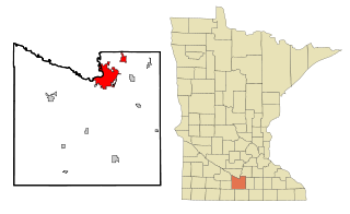
Mankato is a city in Blue Earth, Nicollet, and Le Sueur counties in the U.S. state of Minnesota. It is the county seat of Blue Earth County, Minnesota. The population was 44,488 according to the 2020 census, making it the 21st-largest city in Minnesota, and the 5th-largest outside of the Minneapolis–Saint Paul metropolitan area. It is along a large bend of the Minnesota River at its confluence with the Blue Earth River. Mankato is across the Minnesota River from North Mankato. Mankato and North Mankato have a combined population of 58,763 according to the 2020 census. It completely encompasses the town of Skyline. North of Mankato Regional Airport, a tiny non-contiguous part of the city lies within Le Sueur County. Most of the city is in Blue Earth County.

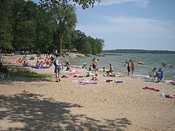
Minneopa State Park is a state park in the U.S. state of Minnesota. It was established in 1905 to preserve Minneopa Falls, a large waterfall for southern Minnesota, and was expanded in the 1960s to include the lower reaches of Minneopa Creek and a large tract of prairie. Minneopa is Minnesota's third oldest state park, after Itasca and Interstate. Two park resources are listed on the National Register of Historic Places: the 1862 Seppman Mill and a district of seven Rustic Style structures built by the Works Progress Administration in the late 1930s. The park is located almost entirely on the south side of the Minnesota River, three miles (4.8 km) west of Mankato. In 2015 the state reintroduced American bison to the park in a 330-acre (130 ha) fenced enclosure, through which visitors can drive in their vehicles.

This is a list of sites in Minnesota which are included in the National Register of Historic Places. There are more than 1,700 properties and historic districts listed on the NRHP; each of Minnesota's 87 counties has at least 2 listings. Twenty-two sites are also National Historic Landmarks.
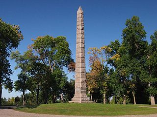
Camp Release State Monument is located on the edge of Montevideo, Minnesota, United States, just off Highway 212 in Lac qui Parle County, in the 6-acre Camp Release State Memorial Wayside. The Camp Release Monument stands as a reminder of Minnesota's early state history. The Minnesota River Valley and Montevideo were important sites in the Dakota War of 1862.

The Battle of Birch Coulee occurred on September 2–3, 1862, and resulted in the heaviest casualties suffered by U.S. forces during the Dakota War of 1862. The battle occurred after a group of Dakota warriors followed a U.S. burial expedition, including volunteer infantry, mounted guards and civilians, to an exposed plain where they were setting up camp. That night, 200 Dakota soldiers surrounded the camp and ambushed the Birch Coulee campsite in the early morning, commencing a siege that lasted for over 30 hours, until the arrival of reinforcements and artillery led by Colonel Henry Hastings Sibley.

The Dakota War of 1862, also known as the Sioux Uprising, the Dakota Uprising, the Sioux Outbreak of 1862, the Dakota Conflict, or Little Crow's War, was an armed conflict between the United States and several eastern bands of Dakota collectively known as the Santee Sioux. It began on August 18, 1862, when the Dakota, who were facing starvation and displacement, attacked white settlements at the Lower Sioux Agency along the Minnesota River valley in southwest Minnesota. The war lasted for five weeks and resulted in the deaths of hundreds of settlers and the displacement of thousands more. In the aftermath, the Dakota people were exiled from their homelands, forcibly sent to reservations in the Dakotas and Nebraska, and the State of Minnesota confiscated and sold all their remaining land in the state. The war also ended with the largest mass execution in United States history with the hanging of 38 Dakota men.

The Rice County Courthouse, located at 218 3rd Street NW in Faribault, Rice County, in the U.S. state of Minnesota, is an Art Deco building constructed of natural-face Faribault stone horizontally banded at intervals with sawed-faced stone. Nairne W. Fisher of St. Cloud was the architect for the courthouse, and is also credited with designing the Pope County Courthouse. The main rotunda has metal fixtures and Art Deco glass. Polished black and gray Tennessee marble is used extensively in the walls, floors, and stairs, with a terrazzo map of Rice County centered on the floor. The 16-foot-high (4.9 m) courtroom on the third floor was finished with fine-grained walnut walls with matching custom-built furnishings. The building was built in 1934 at a cost of $200,000.

The First National Bank of Mankato, also known as the Old First National Bank of Mankato and located at 229 South Front Street in Mankato, Minnesota, United States, is a fine example of Prairie School architecture in a commercial building, relating rural life to the development of downtown Mankato as a regional center of commerce and finance. The recently restored exterior is now part of the Mankato Civic Center, the Mayo Clinic Health System Event Center.

Kern Bridge or Yaeger Bridge crossed the Le Sueur River in Blue Earth County in the U.S. state of Minnesota. It was built in 1873 using a bowstring through truss design by the Wrought Iron Bridge Company. It was 183.5 feet (56 m) long and carried a local road. It was listed on the National Register of Historic Places in 1980 as Minnesota's only bowstring arch truss bridge and oldest road bridge still in use. However, it was closed to vehicle traffic in 1991.
Traverse des Sioux is a historic site in the U.S. state of Minnesota. Once part of a pre-industrial trade route, it is preserved to commemorate that route, a busy river crossing on it, and a nineteenth-century settlement, trading post, and mission at that crossing place. It was a transshipment point for pelts in fur trading days, and the namesake for an important United States treaty that forced the Dakota people to cede part of their homeland and opened up much of southern Minnesota to European-American settlement.

This is a list of the National Register of Historic Places listings in Dakota County, Minnesota. It is intended to be a complete list of the properties and districts on the National Register of Historic Places in Dakota County, Minnesota, United States. Dakota County is located in the southeastern part of the U.S. state of Minnesota, bounded on the northeast side by the Upper Mississippi River and on the northwest by the Minnesota River. The locations of National Register properties and districts for which the latitude and longitude coordinates are included below, may be seen in an online map.

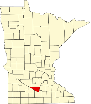
This is a list of the National Register of Historic Places listings in Blue Earth County, Minnesota. It is intended to be a complete list of the properties and districts on the National Register of Historic Places in Blue Earth County, Minnesota, United States. The locations of National Register properties and districts for which the latitude and longitude coordinates are included below, may be seen in an online map.
This is a list of the National Register of Historic Places listings in Nicollet County, Minnesota. It is intended to be a complete list of the properties and districts on the National Register of Historic Places in Nicollet County, Minnesota, United States. The locations of National Register properties and districts for which the latitude and longitude coordinates are included below, may be seen in an online map.

Sibley Park is a city park located at the convergence of the Minnesota and Blue Earth Rivers in Mankato, Minnesota, United States.

Birch Coulee Battlefield in Renville County, Minnesota, United States, was the site of the Battle of Birch Coulee, the costliest military engagement for U.S. forces during the Dakota War of 1862. It is now a historic site with self-guided trails and markers interpreting the battle from both sides. Birch Coulee was nominated to the National Register of Historic Places for having state-level significance in military history, and was listed in 1973.
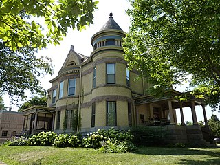
The Lorin Cray House is a historic structure in Mankato, Minnesota. Originally a private home, it was owned by the local YWCA for just over 80 years, from late 1927 until they changed locations in early 2008. It was added to the National Register of Historic Places on July 28, 1980.

The Sibley Historic Site is the site of Henry Hastings Sibley's home, who was the regional manager of the American Fur Company and Minnesota's first governor. It is one of the 26 historical sites that are operated by the Minnesota Historical Society. Located in what is now the city of Mendota, the site consists of four limestone buildings and a large lawn area. Three of the buildings are open for touring, including a fur company cold store from 1843 and the 1840 home of fur trader and hotelier Jean-Baptiste Faribault.

This is a list of the National Register of Historic Places listings in Martin County, Minnesota. It is intended to be a complete list of the properties and districts on the National Register of Historic Places in Martin County, Minnesota, United States. The locations of National Register properties and districts for which the latitude and longitude coordinates are included below, may be seen in an online map.
The Watonwan County Courthouse in St. James, Minnesota, United States, is the seat of government for Watonwan County, in continual use since it was completed in 1896. It was listed on the National Register of Historic Places in 1987 for having state-level significance in the themes of architecture and politics/government. It was nominated for its exemplary Romanesque Revival architecture, its status as one of Minnesota's remaining monumental Victorian courthouses and as a local landmark, and its longstanding service as county seat.

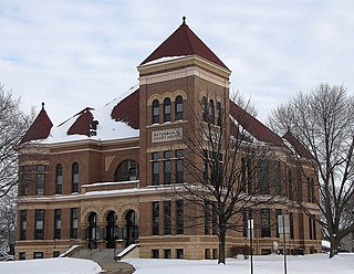
Old Main is a historic academic building on the lower historic campus of Minnesota State University, Mankato in Mankato, Minnesota. Its main section, built in 1924, is dominated by a prominent Jacobethan tower, and is connected to an older 1908 building, now known as the Annex. It was built to replace the original old main also located in lower Mankato that was burned to the ground by a fire in 1922. These structures are the oldest surviving buildings on the original valley campus, which was the first site of the state's second normal school. The state legislature provided funding in 1923 for the development of the site. The 1924 building was designed by Clarence H. Johnston, then the state architect. It currently serves as a nursing home and clinical rotation site for nursing assistant programs in the area.