Monson Lake State Park

Last updated
Monson Lake State Park
06MonsonLake.jpg
Monson Lake
USA Minnesota relief location map.svg
Red pog.svg
Location of Monson Lake State Park in Minnesota
Usa edcp relief location map.png
Red pog.svg
Monson Lake State Park (the United States)
Location Swift, Minnesota, United States
Coordinates 45°19′14″N95°16′13″W / 45.32056°N 95.27028°W / 45.32056; -95.27028 Coordinates: 45°19′14″N95°16′13″W / 45.32056°N 95.27028°W / 45.32056; -95.27028
Area346 acres (140 ha)
Elevation1,253 ft (382 m) [1]
Established1937
Governing bodyMinnesota Department of Natural Resources
Monson Lake State Park CCC/WPA/Rustic Style Historic Resources
MonsonLakePicnicShelter.jpg
Monson Lake State Park's Combination Building
USA Minnesota location map.svg
Red pog.svg
Usa edcp location map.svg
Red pog.svg
Location Swift County, Minnesota, off Co. Rd. 95 SE of Sunburg
Nearest city Sunburg, Minnesota
Area31 acres (13 ha)
Built1936–1938
Architectural style National Park Service rustic
MPS Minnesota State Park CCC/WPA/Rustic Style MPS
NRHP reference No. 89001666
Added to NRHPOctober 25, 1989

Monson Lake State Park is a state park of Minnesota, USA, originally established as a memorial to 13 Swedish American pioneers who were killed there in the Dakota War of 1862. A district of 1930s New Deal structures is on the National Register of Historic Places. [2] Despite being nearly doubled in size in 2009, the state park remains one of Minnesota's smallest. It is located off Minnesota State Highway 9 just west of Sunburg and 20 miles (32 km) northwest of Willmar. [3] :5 This seasonally-staffed park is managed from nearby Sibley State Park. [3] :53

Contents

Geography

Much of Monson Lake State Park's acreage is water, with land mostly comprising isthmuses between, and islands in, the three adjacent lakes of Monson, West Sunburg, and East Sunburg. Monson Lake, whose shore forms the western boundary of the park, is 152 acres (62 ha) and up to 21 feet (6.4 m) deep. [4] West Sunburg Lake is about 178 acres (72 ha). [3] :26 Monson Lake has three inlets, and one outlet to West Sunburg. [4] The lakes are part of the watershed of the Chippewa River, a tributary of the Minnesota River. [3] :24

Natural history

Geology

Monson Lake State Park lies on a band of lakes and rolling hills called the Alexandria Moraine. This moraine was formed by rocks and sediments dropped by the Wadena Lobe of the Laurentide Ice Sheet 30,000 years ago during the last glacial period. [5] The whole region is thickly blanketed with till 100 to 400 feet (30 to 122 m) thick. [3] :23 Blocks of ice that broke off from the glacier melted in place, forming the park's trio of kettle lakes. [5]

Flora

Prior to European settlement the area would have borne tallgrass prairie, with groves of trees growing where the lakes blocked some of the advancing wildfires. [3] :28 Today the park is primarily forested with basswood, bur oak, and green ash with a few stands of northern red oak. Ironwood is abundant in the shrub layer and the understory is characterized by Virginia waterleaf. [3] :28 Other wildflowers include nodding trillium, large-flowered bellwort, Dutchman's breeches, bloodroot, jack-in-the-pulpit, and starry false Solomon seal. [3] :50 There are 42 acres (17 ha) of this habitat type, all of it secondary forest. [3] :11

The lakeshores and other marshes are characterized by emergent plants like prairie bulrush, bur-reed, arrowhead, and spikerush.

Two widespread invasive species are established in the park, common buckthorn and reed canary grass. [3] :28

Fauna

Mammals most commonly found in the park are white-tailed deer, groundhogs, minks, foxes, squirrels, and eastern chipmunks. [5] Monson Lake State Park is located on a major corridor of the Mississippi Flyway and attracts a variety of birds. Regionally threatened or uncommon species include Henslow's sparrows, American white pelicans, Forster's terns, Franklin's gulls, horned grebes, and trumpeter swans. [3] :27

Water quality

At the time of the most recent survey in 2005, Monson Lake was found to have good water clarity and low to moderate nutrient pollution. What pollution there was came largely from agricultural runoff. Aquatic and emergent plants exhibited good density and biodiversity. [4] Monson Lake does experience cyanobacteria blooms in summer, but is free of Eurasian water milfoil and other invasive aquatic plants. [3] :24 The water quality in West Sunburg Lake is considered very high. [3] :50

Climate

The park experiences a humid continental climate of significant temperature variation between summer and winter. The mean temperature in July is 71.8 °F (22.1 °C) and in January 9.7 °F (−12.4 °C). Average annual precipitation has been 31.67 inches (80.4 cm). [3] :22 Average snowfall per year is 53.6 inches (136 cm) and the growing season usually runs 156 days. [3] :23

Cultural history

Three archaeological sites demonstrate that the future park was occupied by Native Americans at least as long ago as the Woodland period (1000 BCE – 1000 CE). Excavation revealed stone tools including obsidian from the Great Plains, flint from the Knife River in North Dakota, and quartzite from near Hixton, Wisconsin, suggesting a wide trade network. [3] :35

Euro-American settlement

When Anders and Daniel Broberg, immigrant brothers from Sweden, purchased 160 acres (65 ha) on July 15, 1861, it was at the very edge of the frontier. Anders and his wife Christiana had four children: Anna Stina, Johannes, Andreas, and Christiana. Daniel and his wife Anna Stina had two sons—Peter and Alfred—and a third, John, would be born that fall. Together with the neighboring families of Swen Oman and Johannes Lundborg they formed what was called the West Lake Settlement. [6] However the growing Euro-American population was making it increasingly difficult for the native Dakota people to pursue their traditional lifestyle. Resettlement on reservations, treaty violations by the United States, and late or unfair annuity payments by Indian agents caused increasing hunger and hardship among the Dakota. [7]

The attack at the Broberg cabin

The site of the Broberg cabin and a 1917 memorial placed by survivor Peter Broberg Broberg Cabin Cellar Hole.jpg
The site of the Broberg cabin and a 1917 memorial placed by survivor Peter Broberg

On the morning of Wednesday, August 20, 1862, most residents in the West Lake Settlement were unaware that violence had broken out between Dakota and white settlers three days earlier. A pastor who circulated among the scattered pioneers was holding a church service at the Lundborg cabin. The Brobergs and the Omans attended, leaving many of the younger children at home. Those at the Broberg cabin were visited by about 30 Dakotas, dressed in war regalia and not as friendly as usual. The frightened settlers sent seven-year-old Peter Broberg to fetch the adults. [8] Anders Broberg and the four sons of Andreas Lundborg hurried the 2 miles (3.2 km) to the scene. [7]

At first the Dakota seemed friendly, but the situation abruptly soured. It is not known whether any of the five white men were armed. [7] Anders and the Lundborg boys were shot, though Samuel Lundborg would survive his wounds. Andreas Lundborg arrived just as his sons were being attacked. Armed but obviously outnumbered, he ran and several Dakota gave chase. At that point, however, the wagon appeared in which Daniel Broberg was driving the women and children home, and the attackers focused on them instead. [7] Daniel was shot and 7-year-old Christiana was clubbed down with a rifle. 16-year-old Anna Stina managed to flee into a cornfield, where she caught up with Andreas Lundborg. Her cousin Peter ran almost 400 yards (370 m) to the Oman cabin, which was in sight. [8] [9] A Dakota tore Peter's baby brother from their mother's hands and threw him to the ground. The warriors tried to take the two Mrs. Brobergs prisoner, but they resisted and were shot. [8]

The Dakota killed the three children and an adult left in the Broberg cabin, and went on to loot the Lundborg cabin. The elder Lundborg had evacuated his remaining family and hidden with Anna Stina Broberg in a slough. They were shot at but no one was hit. Surrounded by open ground, Peter Broberg and the Oman family were trapped in their cabin. Late that afternoon three Dakota approached the Oman home. The six settlers inside managed to duck into the cellar through a trapdoor, and listened as the place was shot up and looted. [8]

Finally the Dakota departed, though the Omans hid in the cellar until after sunset. They emerged and spent the night in the woods, encountering the superficially wounded Samuel Lundborg at dawn. The various survivors gathered on an island in a nearby lake. Two days after the attack, several settlers went to gather and bury the dead. [8] The 13 killed—Anders (age 43), Christiana (36), Johannes (13), Andreas (10), and Christiana Broberg (7); Daniel (38), Anna Stina (30), Alfred (4), and John Broberg (10 months); Andreas (25), Gustaf (23), and Lars Lundborg (22), and Johannes Broberg (age and relation uncertain)—were all buried in a nearby field. [6] Peter and the younger Anna Stina were the only members of their respective families to survive. [7]

As the war broadened, many settlers fled the region. Anna Stina and Peter returned to the area 3 years later, though settlement didn't fully rebound until the 1890s. [6] The victims were reburied in New London, Minnesota, in 1891 and marked with a state-funded monument. [6] Anna Stina had married another West Lake Settlement refugee in 1864 and they moved to Pennington County in northwestern Minnesota in 1880. She died in 1933 at the age of 87. [9] Peter Broberg placed a memorial marker at the cabin site in a 1917 ceremony, and died in New London in 1925. [3] :35 [6]

The Monson Lake Memorial Association

The notion of preserving the Broberg cabin site as a park came to a local resident named Ole Ellingboe on August 20, 1926, the 64th anniversary of the attack. The idea occurred to him while walking past the site on his way to church, where it was received favorably by the rest of the congregation. The next year the Monson Lake Memorial Association formed and raised $225 to buy 2 acres (0.81 ha) from owner Albert Monson. [6]

The dedication of the private memorial park on August 21, 1927, drew 10,000 attendees. The Monson Lake Memorial Association continued to hold wildly popular annual events through the Great Depression, marked by speeches, plays, music, and refreshments. State and national politicians and other dignitaries attended. [6] Following a hiatus during World War II, observances were sporadic but elaborate. The largest-ever attendance was 15,000 in 1958, Minnesota's centennial year. The 1962 event included a two-hour, four-act play. [10]

From the beginning the observations presented only a European American perspective, [11] treating the 13 white victims as veritable martyrs. [10] It wasn't until 1987 that the injustices suffered by the Dakota were included in the programming. That event only drew a few hundred. The 1990 observation featured readings by poet and essayist Bill Holm. [10]

New Deal development

Originally the 2-acre (0.81 ha) park was privately owned by the Monson Lake Memorial Association. During the Great Depression, the Franklin D. Roosevelt administration funded public works projects to ease unemployment, and park development was a significant focus. To this end, in 1935 the Association convinced the Minnesota Emergency Relief Agency to purchase and expand the park. The Veterans Conservation Corps—a branch of the Civilian Conservation Corps for unemployed World War I veterans—had a major camp at nearby Sibley State Park, so a side camp was established at Monson Lake in 1936. The VCC men constructed a Sanitation Building and a Combination Building (a picnic shelter with a public cooking area and space for a concession service). These were built in the National Park Service rustic style with local granite and white oak. Crews from the Works Progress Administration created the gravel entrance road and parking lot. Monson Lake Memorial State Park, as it was originally named, was dedicated in 1938. [6] Since it was designated a memorial state park, only limited recreational facilities were built. [2]

In 1989 31 acres (13 ha) encompassing these structures were added to the National Register of Historic Places. [3] :36 Since low visitation has never spurred significant alterations, it is the only Minnesota state park that remains nearly unchanged from its original development. [2]

Later history

In 1956 the original name Monson Lake Memorial State Park was shortened by officially dropping the word 'memorial.' [6] Additional developments over the years included staff facilities, showers in the Sanitation Building, a boat ramp, and interpretive signage. During the 1962 centennial of the conflict, the Swift County Historical Society donated a memorial plaque. [6] Aside from the irregular annual observances, usage of the state park remained limited. Legislation was even passed in 1965 to hand off the property as a local park, though this was never implemented. [12]

Monson Lake State Park remained 187 acres (76 ha) for decades, with its eastern border including only a sliver of West Sunberg Lake. In the mid-2000s decade, the owners of an undeveloped hunting retreat to the east approached the park about selling to the state rather than a real estate developer. Their 158 acres (64 ha) included most of the rest of West Sunburg Lake and some of East Sunburg Lake. This is unusual because lakes in Minnesota remain public property, but in the 1930s the Sunburg Lakes had been dry and the ownership rights were bought and sold. Approvals and fund appropriation took the state three years, and the $395,000 purchase was finalized in June 2009. [13] The new parcel comprises 44 acres (18 ha) of land and 114 acres (46 ha) of water, with 10,200 feet (3,100 m) of shoreline. [3] :50 The new parcel will be managed as a refuge for waterfowl. [13]

Recreation

Activities at Monson Lake State Park include birdwatching, camping, canoeing, fishing, hiking, and picnicking. The campground has just 20 sites and is only open in summer. [14] There is a boat ramp on Monson Lake. [3] :43 Game fish in Monson Lake are walleye, northern pike, largemouth bass, black crappie, yellow perch, and bluegill. The walleye are stocked biennially. [4] 1.2 miles (1.9 km) of trail currently trace through the park. [14] A canoe route starts at the boat ramp, leads across Monson Lake, and traverses a 463-foot (141 m) portage into West Sunburg Lake. In winter snowshoeing is allowed anywhere in the park. [3] :44

Related Research Articles

Father Hennepin State Park

Father Hennepin State Park is a state park of Minnesota, USA, located on the southeast corner of Mille Lacs Lake. The park is named after Father Louis Hennepin, a priest who visited the area with a French expedition in 1680. The 320-acre (130 ha) park has 103 campsites and a sandy beach over one mile (1.6 km) long.

Moraine State Park State park in Pennsylvania, United States

Moraine State Park is a Pennsylvania state park on 16,725 acres (6,768 ha) in Brady, Clay, Franklin, Muddy Creek, and Worth townships in Butler County, Pennsylvania, in the United States.

Grand Portage State Park State park in Minnesota, United States

Grand Portage State Park is a state park at the northeastern tip of the U.S. state of Minnesota, on the Canada–United States border. It contains a 120-foot (37 m) waterfall, the tallest in the state, on the Pigeon River. The High Falls and other waterfalls and rapids upstream necessitated a historically important portage on a fur trade route between the Great Lakes and inland Canada. This 8.5-mile (13.7 km) path as well as the sites of historic forts at either end are preserved in nearby Grand Portage National Monument.

Crow Wing State Park United States historic place

Crow Wing State Park is a state park of Minnesota, United States, at the confluence of the Mississippi and Crow Wing Rivers. The park interprets the site of Old Crow Wing, one of the most populous towns in Minnesota in the 1850s and 1860s. The entire park was added to the National Register of Historic Places in 1970. A section of the Red River Trails that passed through Old Crow Wing is also separately listed on the National Register.

Buffalo River State Park (Minnesota) United States historic place

Buffalo River State Park is a state park of Minnesota, United States, conserving a prairie bisected by the wooded banks of the Buffalo River. Together with the adjacent Bluestem Prairie Scientific and Natural Area owned by The Nature Conservancy, it protects one of the largest and highest-quality prairie remnants in Minnesota. With the closest swimming lake to the Fargo–Moorhead metropolitan area, however, it is most popular for swimming and picnicking. The 1,068-acre (432 ha) park is located just off U.S. Route 10 in Clay County, 4.5 miles (7.2 km) east of Glyndon and 14 miles (23 km) east of Moorhead.

Minneopa State Park United States historic place

Minneopa State Park is a state park in the U.S. state of Minnesota. It was established in 1905 to preserve Minneopa Falls, a large waterfall for southern Minnesota, and was expanded in the 1960s to include the lower reaches of Minneopa Creek and a large tract of prairie. Minneopa is Minnesota's third oldest state park, after Itasca and Interstate. Two park resources are listed on the National Register of Historic Places: the 1862 Seppman Mill and a district of seven Rustic Style structures built by the Works Progress Administration in the late 1930s. The park is located almost entirely on the south side of the Minnesota River, 3 miles (4.8 km) west of Mankato. In 2015 the state reintroduced American bison to the park in a 330-acre (130 ha) fenced enclosure, through which visitors can drive in their vehicles.

Nerstrand-Big Woods State Park

Nerstrand-Big Woods State Park is a state park of Minnesota, US, northeast of Faribault just outside the small town of Nerstrand. The park derives its name from the Big Woods, a large, contiguous forested area covering much of southeast Minnesota prior to the arrival of European settlers. The park and its forest were an outlying 'woods' typical of and similar to the Big Woods proper, which were historically found on the more recent glacier deposits located west of the Cannon River 10 miles (16 km) to the west. Aside from a small waterfall, the outstanding natural feature of the park is the forest itself.

Blue Mounds State Park

Blue Mounds State Park is a state park of Minnesota, USA, in Rock County near the town of Luverne. It protects an American bison herd which grazes on one of the state's largest prairie remnants.

Bear Head Lake State Park State park of Minnesota, United States

Bear Head Lake State Park is a state park of Minnesota, United States, providing ready access to outdoor recreation in the Boundary Waters region. It boasts scenery similar to the nearby Boundary Waters Canoe Area Wilderness, with the added conveniences of road access, modern facilities, and motorboating. The most popular visitor activities are boating, fishing, swimming, and hiking. The park entirely surrounds 670-acre (270 ha) Bear Head Lake and three other fishing lakes. It was established in 1961 in Saint Louis County near Ely, Minnesota. The park also contains the woodlands surrounding the lakes, which gives an entire total of about 5,540 acres. The park also shares a large border with Bear Island State Forest.

Lake Shetek

Lake Shetek is the largest lake in southwestern Minnesota, United States, and the headwaters of the Des Moines River. It is located in The Lakes, an unincorporated community in Murray County a few miles north-northwest of Currie. The name Shetek is derived from "pelican" in the Ojibwe language.

Judge C. R. Magney State Park State park in Minnesota, United States

Judge C. R. Magney State Park is a state park in the U.S. state of Minnesota, on the North Shore of Lake Superior. It was named for Clarence R. Magney, a former mayor of Duluth and justice of the Minnesota Supreme Court, who was instrumental in getting 11 state parks and scenic waysides established along the North Shore. The park is best known for the Devil's Kettle, an unusual waterfall and rock formation in which half of the Brule River disappears into a pothole.

Flandrau State Park United States historic place

Flandrau State Park is a state park of Minnesota, United States, on the Cottonwood River adjacent to the city of New Ulm. Initially called Cottonwood River State Park, it was renamed in 1945 to honor Charles Eugene Flandrau, a leading citizen of early Minnesota who commanded defenses during the Battles of New Ulm in the Dakota War of 1862. The park was originally developed in the 1930s as a job creation project to provide a recreational reservoir. However the dam was repeatedly damaged by floods and was removed in 1995.

Saint Croix State Park United States historic place

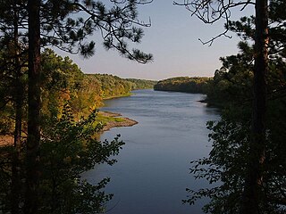
St. Croix State Park is a state park in Pine County, Minnesota, USA. The park follows the shore of the St. Croix River for 21 miles (34 km) and contains the last 7 miles (11 km) of the Kettle River. At 33,895 acres (13,717 ha) it is the largest Minnesota state park. It was developed as a Recreational Demonstration Area in the 1930s, and is one of the finest surviving properties of this type in the nation. 164 structures built by the Civilian Conservation Corps and the Works Progress Administration survive, the largest collection of New Deal projects in Minnesota. As a historic district they were listed on the National Register of Historic Places and proclaimed a National Historic Landmark in 1997.

Scenic State Park

Scenic State Park is a Minnesota state park near Bigfork in Itasca County. It encompasses 3,936 acres (1,593 ha) of virgin pine forests that surround Coon and Sandwick Lakes. It also includes portions of Lake of the Isles, Tell Lake, Cedar Lake and Pine Lake. Established in 1921, the Ojibwe tribe had previously used the area for hunting. The park has places for camping, hiking, swimming, fishing, and canoeing.

Lake Shetek State Park United States historic place

Lake Shetek State Park is a state park of Minnesota, United States, on Lake Shetek, which is the largest lake in southwestern Minnesota and the headwaters of the Des Moines River. It is most popular for water recreation and camping. However the park also contains historical resources related to the Dakota War of 1862, including an original log cabin and a monument to 15 white settlers killed there and at nearby Slaughter Slough on August 20, 1862.

Minnesota State Highway 104 is a 27.320-mile-long (43.967 km) highway in west-central Minnesota, which runs from its intersection with State Highway 9 in Norway Lake Township near Sunburg and continues north to its northern terminus at its intersection with State Highways 28 and 29 in the city of Glenwood.

Beaver Lake State Park (North Dakota) Park in North Dakota, USA

Beaver Lake State Park is a public recreation area located in Logan County, North Dakota, about equidistant from Napoleon and Wishek. The state park occupies 273 acres (110 ha) of land on the western shore of 968-acre (392 ha) Beaver Lake and offers hiking, boating, swimming, fishing, cabins, and campground.

Slaughter Slough

Slaughter Slough is a wetland in southwestern Minnesota, United States, so named for being the site of the Lake Shetek Massacre during the Dakota War of 1862. It is located in Murray County east of Lake Shetek. On August 20, 1862, about 40 Dakota men attacked the Euro-American settlers living nearby, killing 15 and taking a dozen women and children captive. 21 settlers escaped or survived the attack and made difficult journeys across the prairie to safety. A band of pacifist Dakota later ransomed the eight surviving captives, who were reunited with their families.

Greenleaf Lake State Recreation Area

Greenleaf Lake State Recreation Area is a state park unit of Minnesota, USA, currently in development. It includes undeveloped shoreline on both Greenleaf and Sioux Lakes, halfway between the cities of Hutchinson and Litchfield in Meeker County. Portions of the state recreation area (SRA) are open to the public for day-use recreation, but there are no facilities yet on site. The park boundaries were set by the Minnesota Legislature and the state is still acquiring land from willing sellers; two-thirds of the property remain privately owned.

References

  1. "Monson Lake Memorial State Park". Geographic Names Information System . United States Geological Survey. 1980-01-11. Retrieved 2011-02-25.
  2. 1 2 3 "Monson Lake State Park". Rustic Style Resources in Minnesota State Parks. Minnesota Historical Society. Retrieved 2010-08-17.
  3. 1 2 3 4 5 6 7 8 9 10 11 12 13 14 15 16 17 18 19 20 21 "Monson Lake State Park Management Plan" (PDF). Minnesota Department of Natural Resources, Division of Parks and Recreation. March 2008. Retrieved 2011-04-20.Cite journal requires |journal= (help)
  4. 1 2 3 4 "Name: Monson". Lake Information Report. Minnesota Department of Natural Resources. 2005-06-23. Retrieved 2011-04-20.
  5. 1 2 3 "Monson Lake State Park" (PDF). Minnesota Department of Natural Resources. October 2009. Archived from the original (PDF) on 2010-06-02. Retrieved 2011-04-20.Cite journal requires |journal= (help)
  6. 1 2 3 4 5 6 7 8 9 10 "A Brief History of Monson Lake State Park". Minnesota Department of Natural Resources, Division of Parks & Recreation, Interpretive Services. April 2007.Cite journal requires |journal= (help)
  7. 1 2 3 4 5 Dahlin, Curtis A. (2007). Dakota Uprising Victims: Gravestones & Stories. Edina, Minn.: Beaver's Pond Press, Inc. pp. 67–69. ISBN   978-1-59298-170-0.
  8. 1 2 3 4 5 Oman, A.P.; Victor E. Lawson (1935). "The Monson Lake Massacre: An Account of the Massacre of 1862 by the Only Surviving Eye-witness". My Church: An Illustrated Lutheran Manual. Rock Island, Ill.: Augustana Book Concern. 21: 37–46.
  9. 1 2 Cox, Bill (2010-09-01). "Anna Stina Broberg". Find a Grave . Retrieved 2011-03-08.
  10. 1 2 3 Kinkopf, Eric (1990-08-12). "Remaking history: The distant conflicts between Indians and settlers are not so distant in Kerkhoven, Minn. and Wounded Knee, S.D.". St. Paul Pioneer Press. St. Paul, Minn.
  11. Dowlin, Sheryl L. (2000-09-28). The Dakota Conflict Remembered (PDF). 35th Annual Northern Great Plains History Conference. Mankato, Minn. Archived from the original (PDF) on 2012-09-15. Retrieved 2011-04-21.
  12. Meyer, Roy W. (1991). Everyone's Country Estate: A History of Minnesota's State Parks. St. Paul, Minn.: Minnesota Historical Society Press. ISBN   0-87351-266-9.
  13. 1 2 Lange, Carolyn (2009-09-23). "Monson Lake State Park nearly doubles in size". Star Tribune. Minneapolis, Minn.
  14. 1 2 "Monson Lake State Park". Minnesota Department of Natural Resources. Retrieved 2011-04-20.