Sunburg, Minnesota

Last updated

Sunburg, Minnesota
Kandiyohi County Minnesota Incorporated and Unincorporated areas Sunburg Highlighted.svg
Location of Sunburg, Minnesota
Coordinates: 45°20′51″N95°14′24″W / 45.34750°N 95.24000°W / 45.34750; -95.24000
CountryUnited States
State Minnesota
County Kandiyohi
Incorporated September 8, 1951
Government
   Mayor Wayne Rudningen
Area
[1]
  Total0.502 sq mi (1.299 km2)
  Land0.474 sq mi (1.226 km2)
  Water0.028 sq mi (0.073 km2)
Elevation
[2]
1,250 ft (381 m)
Population
 (2020) [3]
  Total94
  Estimate 
(2022) [4]
94
  Density198.31/sq mi (76.65/km2)
Time zone UTC–6 (Central (CST))
  Summer (DST) UTC–5 (CDT)
ZIP Code
56289
Area code 320
FIPS code 27-63454
GNIS feature ID2396005 [2]
Sales tax 7.375% [5]

Sunburg is a city in Kandiyohi County, Minnesota, United States. The population was 94 at the 2020 census. [3]

Contents

Geography

According to the United States Census Bureau, the city has a total area of 0.502 square miles (1.30 km2), of which 0.474 square miles (1.23 km2) is land and 0.028 square miles (0.07 km2) is water. [1]

Minnesota State Highways 9 and 104 are two of the main routes in the community.

Monson Lake State Park is just west of the town.

Demographics

Historical population
CensusPop.Note
1960 161
1970 144−10.6%
1980 130−9.7%
1990 117−10.0%
2000 110−6.0%
2010 100−9.1%
2020 94−6.0%
2022 (est.)94 [4] 0.0%
U.S. Decennial Census [6]
2020 Census [3]

2010 census

As of the 2010 census there were 100 people, 47 households and 25 families residing in the city. The population density was 212.8 inhabitants per square mile (82.2/km2). There were 57 housing units at an average density of 121.3 per square mile (46.8/km2). The racial makeup of the city was 99.0% White and 1.0% from two or more races.

There were 47 households, of which 25.5% had children under the age of 18 living with them, 42.6% were married couples living together, 2.1% had a female householder with no husband present, 8.5% had a male householder with no wife present, and 46.8% were non-families. 46.8% of all households were made up of individuals, and 29.8% had someone living alone who was 65 years of age or older. The average household size was 2.13 and the average family size was 3.12.

The median age in the city was 43 years. 24% of residents were under the age of 18; 4% were between the ages of 18 and 24; 27% were from 25 to 44; 22% were from 45 to 64; and 23% were 65 years of age or older. The gender makeup of the city was 61.0% male and 39.0% female.

2000 census

As of the 2000 census, there were 110 people, 51 households and 32 families residing in the city. The population density was 227.9 inhabitants per square mile (88.0/km2). There were 55 housing units at an average density of 114.0 per square mile (44.0/km2). The racial makeup of the city was 100.00% White.

There were 51 households, of which 17.6% had children under the age of 18 living with them, 49.0% were married couples living together, 5.9% had a female householder with no husband present, and 35.3% were non-families. 31.4% of all households were made up of individuals, and 11.8% had someone living alone who was 65 years of age or older. The average household size was 2.16 and the average family size was 2.73.

15.5% of the population were under the age of 18, 8.2% from 18 to 24, 28.2% from 25 to 44, 21.8% from 45 to 64, and 26.4% who were 65 years of age or older. The median age was 44 years. For every 100 females, there were 139.1 males. For every 100 females age 18 and over, there were 144.7 males.

The median household income was $22,500 and the median family income was $28,750. Males had a median income of $26,875 compared with $18,333 for females. The per capita income for the city was $11,654. There were 13.3% of families and 17.8% of the population living below the poverty line, including no under eighteens and 17.6% of those over 64.

Related Research Articles

<span class="mw-page-title-main">Pleasant Plain, Iowa</span> City in Iowa, United States

Pleasant Plain is a city in northeast Penn Township, Jefferson County, Iowa, United States. At the time of the 2020 census, the population was 84.

<span class="mw-page-title-main">Waverly, Kansas</span> City in Coffey County, Kansas

Waverly is a city in Coffey County, Kansas, United States. As of the 2020 census, the population of the city was 574.

<span class="mw-page-title-main">Denton, Kansas</span> City in Doniphan County, Kansas

Denton is a city in Doniphan County, Kansas, United States. As of the 2020 census, the population of the city was 130.

<span class="mw-page-title-main">Prescott, Kansas</span> City in Kansas, United States

Prescott is a city in Linn County, Kansas, United States. As of the 2020 census, the population of the city was 207.

<span class="mw-page-title-main">Meade, Kansas</span> City in Meade County, Kansas

Meade is a city in and the county seat of Meade County, Kansas, United States. As of the 2020 census, the population of the city was 1,505.

<span class="mw-page-title-main">Ness City, Kansas</span> City in Ness County, Kansas

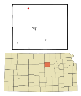
Ness City is a city in and the county seat of Ness County, Kansas, United States. As of the 2020 census, the population of the city was 1,329. Ness City is famous for its four-story Old Ness County Bank Building located downtown, and nicknamed Skyscraper of the Plains.

<span class="mw-page-title-main">Delphos, Kansas</span> City in Ottawa County, Kansas

Delphos is a city in Ottawa County, Kansas, United States. As of the 2020 census, the population of the city was 302. The community was named after Delphos, Ohio.

<span class="mw-page-title-main">Mayfield, Kansas</span> City in Sumner County, Kansas

Mayfield is a city in Sumner County, Kansas, United States. As of the 2020 census, the population of the city was 75.

<span class="mw-page-title-main">Foley, Minnesota</span> City in Minnesota, United States

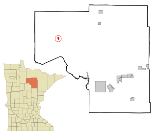
Foley is a city and the county seat of Benton County, Minnesota, United States. The population was 2,711 at the 2020 census.

<span class="mw-page-title-main">Trommald, Minnesota</span> City in Minnesota, United States

Trommald is a city in Crow Wing County, Minnesota, United States. The population was 99 at the 2020 census. It is part of the Brainerd Micropolitan Statistical Area.

<span class="mw-page-title-main">Squaw Lake, Minnesota</span> City in Minnesota, United States

Squaw Lake is a city in Itasca County, Minnesota, United States. The population was 98 at the 2020 census.

<span class="mw-page-title-main">Hillman, Minnesota</span> City in Minnesota, United States

Hillman is a city in Morrison County, Minnesota, United States. The population was 23 at the 2020 census.

<span class="mw-page-title-main">Lastrup, Minnesota</span> City in Minnesota, United States

Lastrup is a city in Morrison County, Minnesota, United States. The population was 120 at the 2020 census.

<span class="mw-page-title-main">Iron Junction, Minnesota</span> City in Minnesota, United States

Iron Junction is a city in Saint Louis County, Minnesota, United States. The population was 110 at the 2020 census.

<span class="mw-page-title-main">Danvers, Minnesota</span> City in Minnesota, United States

Danvers is a city in Swift County, Minnesota, United States. The population was 103 at the 2020 census. The community is named after Danvers, Massachusetts.

<span class="mw-page-title-main">Kerkhoven, Minnesota</span> City in Minnesota, United States

Kerkhoven is a city in Swift County, Minnesota, United States, located roughly 100 miles (160 km) west of the Twin Cities region of Minneapolis/St. Paul along U.S. Route 12. The population was 759 as per the 2010 census.

<span class="mw-page-title-main">Wolverton, Minnesota</span> City in Minnesota, United States

Wolverton is a city in Wilkin County, Minnesota, United States. The population was 128 at the 2020 census. It is part of the Wahpeton, ND—MN Micropolitan Statistical Area.

<span class="mw-page-title-main">Woodworth, North Dakota</span> City in North Dakota, United States

Woodworth is a city in Stutsman County, North Dakota, United States. The population was 44 at the 2020 census.

<span class="mw-page-title-main">Alamo, North Dakota</span> City in North Dakota, United States

Alamo is a city in Williams County, North Dakota, United States. The population was 53 at the 2020 census. Alamo was founded in 1916.

<span class="mw-page-title-main">Lake Quivira, Kansas</span> City in Kansas, United States

Lake Quivira is a city in Johnson and Wyandotte counties in the State of Kansas, and part of the Kansas City Metropolitan Area. As of the 2020 census, the population of the city was 1,014.

References

  1. 1 2 "2023 U.S. Gazetteer Files". United States Census Bureau. Retrieved July 24, 2022.
  2. 1 2 U.S. Geological Survey Geographic Names Information System: Sunburg, Minnesota
  3. 1 2 3 "Explore Census Data". United States Census Bureau . Retrieved February 6, 2024.
  4. 1 2 "City and Town Population Totals: 2020-2022". United States Census Bureau. February 6, 2024. Retrieved February 6, 2024.
  5. "Sunburg (MN) sales tax rate" . Retrieved February 6, 2024.
  6. "Census of Population and Housing". census.gov. Retrieved June 4, 2015.