Atwater, Minnesota

Last updated

Atwater
Hotel Atwater.jpg
Atwater City Hall, built as a hotel in 1904
Kandiyohi County Minnesota Incorporated and Unincorporated areas Atwater Highlighted.svg
Location of Atwater, Minnesota
Coordinates: 45°08′08″N94°46′37″W / 45.13556°N 94.77694°W / 45.13556; -94.77694
CountryUnited States
State Minnesota
County Kandiyohi
Founded1869
Incorporated February 17, 1876
Area
[1]
  Total1.08 sq mi (2.80 km2)
  Land1.03 sq mi (2.67 km2)
  Water0.05 sq mi (0.13 km2)
Elevation
[2]
1,214 ft (370 m)
Population
 (2020) [3]
  Total1,124
  Estimate 
(2021) [4]
1,114
  Density1,091.26/sq mi (421.15/km2)
Time zone UTC-6 (Central)
  Summer (DST) UTC-5 (CDT)
ZIP code
56209
Area code 320
FIPS code 27-02692 [5]
GNIS feature ID2394020 [2]
Website atwatermn.gov

Atwater is a city in Kandiyohi County, Minnesota, United States. The population was 1,124 at the 2020 census. [3]

Contents

Geography

According to the United States Census Bureau, the city has a total area of 1.08 square miles (2.80 km2), of which 1.03 square miles (2.67 km2) is land and 0.05 square miles (0.13 km2) is water. [6]

U.S. Route 12 serves as a main route in the city.

History

Atwater was laid out in 1869, and incorporated on February 17, 1876. [7] The city was named for E. D. Atwater, a railroad official. [7] A post office has been in operation at Atwater since 1870. [8]

Education

Atwater is part of a consolidated school district with the cities of Cosmos and Grove City, which comprise the "ACGC" school district. Their mascot name is the Falcons. School colors are teal, black and silver. Currently, students in grades 5-12 attend classes in the neighboring town of Grove City. Younger students from Atwater attend ACGC North Elementary located approximately one-quarter mile from the downtown.

Government

The town has a three-person police department. [9]

Demographics

Historical population
CensusPop.Note
1880 302
1890 42942.1%
1900 58837.1%
1910 6002.0%
1920 73522.5%
1930 694−5.6%
1940 81517.4%
1950 8808.0%
1960 8992.2%
1970 9566.3%
1980 1,12818.0%
1990 1,053−6.6%
2000 1,0792.5%
2010 1,1335.0%
2020 1,124−0.8%
2021 (est.)1,114 [4] −0.9%
U.S. Decennial Census [10]
2020 Census [3]

2010 census

As of the census of 2010, there were 1,133 people, 468 households, and 312 families living in the city. The population density was 1,100.0 inhabitants per square mile (424.7/km2). There were 494 housing units at an average density of 479.6 per square mile (185.2/km2). The racial makeup of the city was 97.2% White, 0.1% African American, 0.1% Native American, 0.3% Asian, 2.0% from other races, and 0.4% from two or more races. Hispanic or Latino of any race were 4.0% of the population.

There were 468 households, of which 32.9% had children under the age of 18 living with them, 51.7% were married couples living together, 10.3% had a female householder with no husband present, 4.7% had a male householder with no wife present, and 33.3% were non-families. 29.1% of all households were made up of individuals, and 13.7% had someone living alone who was 65 years of age or older. The average household size was 2.37 and the average family size was 2.91.

The median age in the city was 37.7 years. 25.1% of residents were under the age of 18; 8.2% were between the ages of 18 and 24; 23.4% were from 25 to 44; 28.8% were from 45 to 64; and 14.7% were 65 years of age or older. The gender makeup of the city was 49.2% male and 50.8% female.

2000 census

As of the census of 2000, there were 1,079 people, 461 households, and 296 families living in the city. The population density was 1,053.3 inhabitants per square mile (406.7/km2). There were 475 housing units at an average density of 463.7 per square mile (179.0/km2). The racial makeup of the city was 97.96% White, 0.09% African American, 0.09% Native American, 0.19% Asian, 0.09% Pacific Islander, 0.74% from other races, and 0.83% from two or more races. Hispanic or Latino of any race were 1.30% of the population.

There were 461 households, out of which 27.5% had children under the age of 18 living with them, 53.4% were married couples living together, 8.2% had a female householder with no husband present, and 35.6% were non-families. 32.3% of all households were made up of individuals, and 20.0% had someone living alone who was 65 years of age or older. The average household size was 2.31 and the average family size was 2.89.

In the city, the population was spread out, with 23.3% under the age of 18, 9.2% from 18 to 24, 25.1% from 25 to 44, 24.1% from 45 to 64, and 18.4% who were 65 years of age or older. The median age was 41 years. For every 100 females, there were 91.0 males. For every 100 females age 18 and over, there were 89.0 males.

The median income for a household in the city was $39,265, and the median income for a family was $48,289. Males had a median income of $30,365 versus $22,625 for females. The per capita income for the city was $21,112. About 4.1% of families and 5.5% of the population were below the poverty line, including 7.1% of those under age 18 and 4.0% of those age 65 or over.

Notable people

Related Research Articles

<span class="mw-page-title-main">Kandiyohi County, Minnesota</span> County in Minnesota, United States

Kandiyohi County is a county in the U.S. state of Minnesota. As of the 2020 census, its population is 43,732. As of November 20, 1871, its county seat is Willmar.

<span class="mw-page-title-main">Blomkest, Minnesota</span> City in Minnesota, United States

Blomkest is a city in Kandiyohi County, Minnesota, United States. The population was 157 at the 2010 census.

Colfax Township is a township in Kandiyohi County, Minnesota, United States. The population was 557 at the 2000 census.

East Lake Lillian Township is a township in Kandiyohi County, Minnesota, United States. The population was 225 at the 2000 census.

Fahlun Township is a township in Kandiyohi County, Minnesota, United States. The population was 412 at the 2000 census.

Gennessee Township is a township in Kandiyohi County, Minnesota, United States. The population was 458 at the 2000 census. The township includes the city of Atwater.

Harrison Township is a township in Kandiyohi County, Minnesota, United States. The population was 665 at the 2000 census.

Holland Township is a township in Kandiyohi County, Minnesota, United States. The population was 369 at the 2000 census.

<span class="mw-page-title-main">Kandiyohi, Minnesota</span> City in Minnesota, United States

Kandiyohi is a city in Kandiyohi County, Minnesota, United States. The population was 491 at the 2010 census.

Kandiyohi Township is a township in Kandiyohi County, Minnesota, United States. The population was 600 at the 2000 census.

<span class="mw-page-title-main">Lake Lillian, Minnesota</span> City in Minnesota, United States

Lake Lillian is a city in Kandiyohi County, Minnesota, United States. The population was 238 at the 2010 census.

Lake Lillian Township is a township in Kandiyohi County, Minnesota, United States. The population was 221 at the 2000 census. The township is named after the wife of Edwin Whitefield, Lillian. Edwin come and explore this area in 1856 and created paintings of the area.

New London Township is a township in Kandiyohi County, Minnesota, United States. The population was 3,057 at the 2000 census.

<span class="mw-page-title-main">Pennock, Minnesota</span> City in Minnesota, United States

Pennock is a city in Kandiyohi County, Minnesota, United States. The population was 508 at the 2010 census.

<span class="mw-page-title-main">Prinsburg, Minnesota</span> City in Minnesota, United States

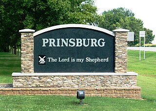
Prinsburg is a city in Kandiyohi County, Minnesota, United States. The population was 497 at the 2010 census.

<span class="mw-page-title-main">Raymond, Minnesota</span> City in Minnesota, United States

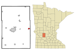
Raymond is a city in southwest Kandiyohi County, Minnesota, United States. The population was 764 at the 2010 census.

<span class="mw-page-title-main">Regal, Minnesota</span> City in Minnesota, United States

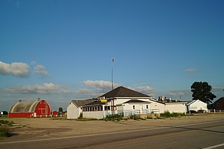
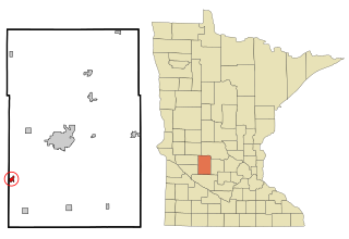
Regal is a city in northeast Kandiyohi County, Minnesota, United States, along the North Fork of the Crow River. The population was 34 at the 2010 census.

St. Johns Township is a township in Kandiyohi County, Minnesota, United States. The population was 386 at the 2000 census.

<span class="mw-page-title-main">Sunburg, Minnesota</span> City in Minnesota, United States

Sunburg is a city in Kandiyohi County, Minnesota, United States. The population was 100 at the 2010 census.

Whitefield Township is a township in Kandiyohi County, Minnesota, United States. The population was 571 at the 2000 census.

References

  1. "2020 U.S. Gazetteer Files". United States Census Bureau. Retrieved July 24, 2022.
  2. 1 2 U.S. Geological Survey Geographic Names Information System: Atwater, Minnesota
  3. 1 2 3 "Explore Census Data". United States Census Bureau . Retrieved May 2, 2023.
  4. 1 2 "City and Town Population Totals: 2020-2021". United States Census Bureau. May 2, 2022. Retrieved May 2, 2022.
  5. "U.S. Census website". United States Census Bureau . Retrieved January 31, 2008.
  6. "US Gazetteer files 2010". United States Census Bureau. Archived from the original on January 12, 2012. Retrieved November 13, 2012.
  7. 1 2 Upham, Warren (1920). Minnesota Geographic Names: Their Origin and Historic Significance. Minnesota Historical Society. p.  https://archive.org/details/minnesotageogra00uphagoog/page/n288 269].
  8. "Kandiyohi County". Jim Forte Postal History. Retrieved July 15, 2015.
  9. http://www.atwaterchamber.com/city%20government.html Archived July 22, 2014, at the Wayback Machine ; accessed September 5, 2014
  10. United States Census Bureau. "Census of Population and Housing" . Retrieved September 11, 2013.