
Lac qui Parle County is a county in the southwestern part of the U.S. state of Minnesota. As of the 2020 census, the population was 6,719. Its county seat is Madison. The largest city in the county is Dawson.

Chippewa County is a county in the U.S. state of Minnesota. As of the 2020 census, the population was 12,598. Its county seat is Montevideo. The county was formed in 1862, and was organized in 1868.

The Lac qui Parle River is a tributary of the Minnesota River, 118 miles (190 km) long, in southwestern Minnesota in the United States. A number of tributaries of the river, including its largest, the West Branch Lac qui Parle River, also flow in eastern South Dakota. Via the Minnesota River, the Lac qui Parle River is part of the watershed of the Mississippi River, draining an area of 1,156 square miles (2,990 km2) in an agricultural region. Slightly more than two-thirds of the Lac qui Parle watershed is in Minnesota.

Wild River State Park is a state park of Minnesota, United States, curving along 18 miles (29 km) of the St. Croix River. This long, narrow park is shaped somewhat like a sideways 'S', with development largely concentrated in the lower third. The remote upper sections flank the mouth of a tributary called the Sunrise River. The park is managed to provide quieter, more nature-oriented recreation as a counterpoint to the busier William O'Brien and Interstate State Parks downstream.

This is a list of sites in Minnesota which are included in the National Register of Historic Places. There are more than 1,700 properties and historic districts listed on the NRHP; each of Minnesota's 87 counties has at least 2 listings. Twenty-two sites are also National Historic Landmarks.

Jay Cooke State Park is a state park of Minnesota, United States, protecting the lower reaches of the Saint Louis River. The park is located about 10 miles (16 km) southwest of Duluth and is one of the ten most visited state parks in Minnesota. The western half of the park contains part of a rocky, 13-mile (21 km) gorge. This was a major barrier to Native Americans and early Europeans traveling by canoe, which they bypassed with the challenging Grand Portage of the St. Louis River. The river was a vital link connecting the Mississippi waterways to the west with the Great Lakes to the east.
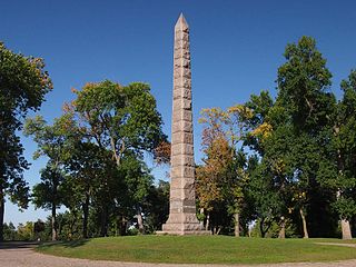
Camp Release State Monument is located on the edge of Montevideo, Minnesota, United States, just off Highway 212 in Lac qui Parle County, in the 6-acre Camp Release State Memorial Wayside. The Camp Release Monument stands as a reminder of Minnesota's early state history. The Minnesota River Valley and Montevideo were important sites in the Dakota War of 1862.

Flandrau State Park is a state park of Minnesota, United States, on the Cottonwood River adjacent to the city of New Ulm. Initially called Cottonwood River State Park, it was renamed in 1945 to honor Charles Eugene Flandrau, a leading citizen of early Minnesota who commanded defenses during the Battles of New Ulm in the Dakota War of 1862. The park was originally developed in the 1930s as a job creation project to provide a recreational reservoir. However the dam was repeatedly damaged by floods and was removed in 1995.
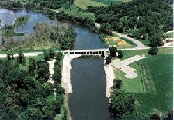
Lac qui Parle is a lake located in western Minnesota, United States, which was widened by the damming of the Minnesota River. The dam was built by the Works Progress Administration (WPA) in 1939. It was reconstructed in 1996. "Lac qui Parle" is a French translation of the native Dakota name, "Mde Lyedan", meaning "lake which speaks".
The Lac qui Parle County Courthouse, located at 600 6th Street in Madison, Lac qui Parle County in the U.S. state of Minnesota is a Richardsonian Romanesque style building featuring a high central tower, built in 1899 at a cost of $30,689.

Straddling the headwaters of the Minnesota River in west-central Minnesota, Big Stone National Wildlife Refuge is within the heart of the tallgrass prairie's historic range. Today, less than one-percent of tallgrass prairie remains.

This is a list of the National Register of Historic Places listings in Chippewa County, Minnesota. It is intended to be a complete list of the properties and districts on the National Register of Historic Places in Chippewa County, Minnesota, United States. The locations of National Register properties and districts for which the latitude and longitude coordinates are included below, may be seen in an online map.

This is a list of the National Register of Historic Places listings in Lac qui Parle County, Minnesota. It is intended to be a complete list of the properties and districts on the National Register of Historic Places in Lac qui Parle County, Minnesota, United States. The locations of National Register properties and districts for which the latitude and longitude coordinates are included below, may be seen in an online map.
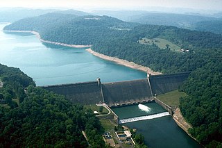
Tygart Dam — also known as Tygart River Dam — is a gravity dam built (1934-38) and operated by the United States Army Corps of Engineers in Taylor County, West Virginia, United States. The dam regulates the waters of the Tygart Valley River. Its storage reservoir is known as Tygart Lake. Most of the lakeshore is occupied by Tygart Lake State Park and Pleasant Creek Wildlife Management Area. The structure was listed on the National Register of Historic Places in 1995.
Fort Renville, originally called Fort Adam, was a fur-trading post established by Joseph Renville and built in 1826. The fort was used as a trading post for the Columbia Fur Company, which was later purchased by the American Fur Company. The American Fur Company continued to use the post until 1846, when it moved to another site. There are no visible remains at its site, a half mile from the Lac qui Parle Mission, in Lac qui Parle State Park near Watson, Minnesota, United States. It was a significant post during the fur-trading years, but fell out of use after Renville's death in 1846. The site has been damaged by flooding and is now held in preservation by the Minnesota Historical Society. It is not open to the public. There is an overlook of the site with a sign detailing a brief history of the fur-trading post for visitors.
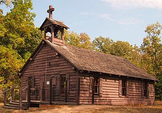
Lac qui Parle Mission is a pre-territorial mission in Chippewa County, Minnesota, United States, which was founded in June 1835 by Dr. Thomas Smith Williamson and Alexander Huggins after fur trader Joseph Renville invited missionaries to the area. "Lac qui Parle" is the French translation of the native Dakota name, "Mde Lyedan," meaning "lake which speaks". In the 19th century, the first dictionary of the Dakota language was written, and part of the Bible was translated into that language for the first time at a mission on the site of the park. It was a site for Christian missionary work to the Sioux for nearly 20 years. Renville was related to and had many friends in the Native community, and after his death in 1846, the mission was taken over by the "irreligious" Martin McLeod. The relationship between the mission and the Dakota people worsened, and in 1854 the missionaries abandoned the site and relocated to the Upper Sioux Agency.
Lac qui Parle is a lake in Minnesota.

Lacey-Keosauqua State Park is located southwest of Keosauqua, Iowa, United States. The park is located along the Des Moines River in Van Buren County. First dedicated in 1921, it is the largest state park in size in Iowa. In 1990, three areas were named nationally recognized historic districts and listed on the National Register of Historic Places.
Lac qui Parle is an unincorporated community in Lac qui Parle Township, Lac qui Parle County, Minnesota, United States. Lac qui Parle Village is the county's first permanently settled community, starting in 1868.


