Louis Hennepin, OFM was a Belgian Catholic priest and missionary best known for his activities in North America. A member of the Recollects, a minor branch of the Franciscans, he travelled to New France and proselytised to several Native American tribes.

Zippel Bay State Park is a state park in Lake of the Woods County, Minnesota in the United States. It is on the white sand beach shoreline of the Lake of the Woods, near the United States border with Canada. The park is open for year-round recreation including camping, hiking, fishing and cross-country skiing.

Cuyuna Country State Recreation Area (CCSRA) is a state park unit of Minnesota, USA, being developed to rehabilitate a portion of the Cuyuna Range where mining pits and piles of waste rock were left behind after decades of open-pit mining for iron ore. Abandoned by mining companies more than 20 years ago, the state recreation area consists of regenerated vegetation and clear lakes that draw a wide range of recreation enthusiasts. The park is located off Minnesota State Highway 210, near the towns of Crosby, Ironton and Cuyuna. The Croft Mine Historical Park, formerly city-run, is now part of the state recreation area.

Red River State Recreation Area is part of the Greater Grand Forks Greenway and is located in the city of East Grand Forks, Minnesota on the banks of the Red River of the North and the Red Lake River. It was built as a natural buffer as a direct response to the 1997 Red River flood.

Minnesota Valley State Recreation Area is a 5,490-acre (2,222 ha) unit of the Minnesota state park system in Scott County, Minnesota, the United States. The park is not continuous but is composed of waysides, four of which are strung along the Minnesota River between Shakopee and Belle Plaine. The various waysides are interspersed with units of the Minnesota Valley National Wildlife Refuge, a part of the Mississippi National River and Recreation Area. Although the state recreation area is managed by the Minnesota Department of Natural Resources and the national wildlife refuge by the United States Fish and Wildlife Service, both agencies share a consistent signage to simplify visitation.

The Minnesota Department of Natural Resources, or Minnesota DNR, is the agency of the U.S. state of Minnesota charged with conserving and managing the state's natural resources. The agency maintains areas such as state parks, state forests, recreational trails, and recreation areas as well as managing minerals, wildlife, and forestry throughout the state. The agency is divided into six divisions - Ecological & Water Resources, Enforcement, Fish & Wildlife, Forestry, Lands & Minerals, and Parks & Trails.
LaSalle Lake State Fish and Wildlife Area is an Illinois state park on 2,058 acres (833 ha) in LaSalle County, Illinois, United States. It is a man-made lake, built as a cooling pond for the LaSalle County Generating Station.
The Fond du Lac State Forest is a state forest in Minnesota, United States, principally managed by the Minnesota Department of Natural Resources (MDNR). The main segment of the forest is located between the towns of Sawyer and Cromwell, in Carlton County. The boundaries of the forest overlap with those of the Fond du Lac Indian Reservation, some state forest land falls within the reservation. The Kettle Lake Wildlife Management Area is located in the southern half of the main segment. A smaller segment is located adjacent to Jay Cooke State Park and the border with Wisconsin in Saint Louis County.
The Bear Island State Forest is a state forest in Minnesota bordered by the towns of Ely, Babbitt, and Tower in Lake and Saint Louis counties. It is adjacent to the Burntside State Forest and the federally managed Superior National Forest and Boundary Waters Canoe Area Wilderness. It is managed primarily by the Minnesota Department of Natural Resources and the counties.
The Blackduck State Forest is a state forest near the town of Blackduck, located in Beltrami and Itasca counties in Minnesota. It is adjacent to the Buena Vista State Forest and the federally managed Chippewa National Forest. It is managed primarily by the Minnesota Department of Natural Resources and the counties.
The Birch Lakes State Forest is a state forest located in Stearns County, Minnesota. One of the smallest Minnesota state forests, it is managed primarily for recreation by the Minnesota Department of Natural Resources. Big Birch Lake, a 2,112 acres (855 ha) sand- and marl-bottomed lake, is accessible from the northeast corner of the forest. The forest is located in a transitory ecotone between the temperate deciduous forest to the northeast and the tallgrass prairie to the southwest, with the rolling terrain characteristic of the glacial activity in the area.
The Hill River State Forest is a state forest located in Aitkin County, Minnesota. It borders the Savanna State Forest to the east, and the Chippewa National Forest and the Land O'Lakes State Forest to the west. The majority of the forest is managed by the Minnesota Department of Natural Resources.

The Northwest Angle State Forest is a state forest located in Lake of the Woods County, Minnesota. The name of the forest is derived from its location near the Northwest Angle, the northernmost point of the contiguous United States. The forest borders the Canadian provinces of Manitoba and Ontario, and the Red Lake Indian Reservation. The forest is managed by the Minnesota Department of Natural Resources.

The Wisconsin State Natural Areas Program is a conservation program created to highlight and protect areas with outstanding natural or archaeological resources in the U.S. state of Wisconsin. There are currently 687 State Natural Areas (SNAs) encompassing almost 400,000 acres (160,000 ha). SNAs protect natural communities, geological formations, and archaeological sites for research purposes and as refuges for biodiversity and endangered or threatened species.

Greenleaf Lake State Recreation Area is a state park unit of Minnesota, USA, currently in development. It includes undeveloped shoreline on both Greenleaf and Sioux Lakes, halfway between the cities of Hutchinson and Litchfield in Meeker County. Portions of the state recreation area (SRA) are open to the public for day-use recreation, but there are no facilities yet on site. The park boundaries were set by the Minnesota Legislature and the state is still acquiring land from willing sellers; two-thirds of the property remain privately owned.

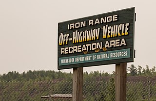
Iron Range Off-Highway Vehicle State Recreation Area is a Minnesota state park located east of Lake Ore-be-gone in Gilbert, Minnesota. The recreation area consists of 36 miles (58 km) of trails on a 1,864-acre (754 ha) unit, all of which was local iron ore mining land until 1981. A 3,500-acre (1,400 ha) expansion of the recreation area is also being planned, with land acquisition underway.

Minnesota Valley State Trail is a 27-mile, multi-use trail in the Minneapolis-Saint Paul metropolitan area that runs parallel to the Minnesota River from the cities of Belle Plaine to Shakopee. A 10-mile segment of the trail from Chaska to Shakopee is paved. Allowable trail uses include hiking, biking, horseback riding, cross-country skiing, and snowmobiling. First established in 1969, and never fully completed, the trail is undergoing a 13.5 mile extension in 2019 and 2020.


