A cave or cavern is a natural void under the Earth's surface. Caves often form by the weathering of rock and often extend deep underground. Exogene caves are smaller openings that extend a relatively short distance underground. Caves which extend further underground than the opening is wide are called endogene caves.

Karst is a topography formed from the dissolution of soluble carbonate rocks such as limestone and dolomite. It is characterized by features like poljes above and drainage systems with sinkholes and caves underground. There is some evidence that karst may occur in more weathering-resistant rocks such as quartzite given the right conditions.

A sinkhole is a depression or hole in the ground caused by some form of collapse of the surface layer. The term is sometimes used to refer to doline, enclosed depressions that are also known as shakeholes, and to openings where surface water enters into underground passages known as ponor, swallow hole or swallet. A cenote is a type of sinkhole that exposes groundwater underneath. Sink, and stream sink are more general terms for sites that drain surface water, possibly by infiltration into sediment or crumbled rock.

Minnehaha Park is a city park in Minneapolis, Minnesota, United States, and home to Minnehaha Falls and the lower reaches of Minnehaha Creek. Officially named Minnehaha Regional Park, it is part of the Minneapolis Park and Recreation Board system and lies within the Mississippi National River and Recreation Area, a unit of the National Park Service. The park was designed by landscape architect Horace W.S. Cleveland in 1883 as part of the Grand Rounds Scenic Byway system, and was part of the popular steamboat Upper Mississippi River "Fashionable Tour" in the 1800s.

The Arbuckle Mountains are an ancient mountain range in south-central Oklahoma in the United States. They lie in Murray, Carter, Pontotoc, and Johnston counties. The granite rocks of the Arbuckles date back to the Precambrian Eon some 1.4 billion years ago which were overlain by rhyolites during the Cambrian Period. The range reaches a height of 1,412 feet above sea level. According to the U.S. Geological Survey (USGS):
The Arbuckles contain the most diverse suite of mineral resources in Oklahoma: limestone, dolomite, glass sand, granite, sand and gravel, shale, cement, iron ore, lead, zinc, tar sands, and oil and gas; all these minerals are, or have been, produced commercially.

The Driftless Area, also known as Bluff Country and the Paleozoic Plateau, is a topographical and cultural region in the Midwestern United States that comprises southwestern Wisconsin, southeastern Minnesota, northeastern Iowa, and the extreme northwestern corner of Illinois. The Driftless Area is a USDA Level III Ecoregion: Ecoregion 52. The Driftless Area takes up a large portion of the Upper Midwest forest–savanna transition. The eastern section of the Driftless Area in Minnesota is called the Blufflands, due to the steep bluffs and cliffs around the river valleys. The western half is known as the Rochester Plateau, which is flatter than the Blufflands. The Coulee Region is the southwestern part of the Driftless Area in Wisconsin. It is named for its numerous ravines.
Forestville is a ghost town in section 13 of Forestville Township in Fillmore County, Minnesota, United States. The nearest communities are Wykoff, to the northwest, and Preston, to the northeast.

The Greenbrier River is a tributary of the New River, 162 miles (261 km) long, in southeastern West Virginia, in the United States. Via the New, Kanawha and Ohio rivers, it is part of the watershed of the Mississippi River, draining an area of 1,656 square miles (4,290 km2). It is one of the longest rivers in West Virginia.

Bluespring Caverns is a cave system located in Lawrence County, Indiana, approximately 80 miles (128 km) south of Indianapolis. The cave system is a karst and river type cave formation and drains a 15 miles² (38.8 km2) sinkhole plain. The cave contains 21 miles (34 km) of surveyed passages and is most notable for having the longest known subterranean river in the United States with approximately 3 miles (4.8 km) of navigable river.
Greenleafton is an unincorporated community in York Township, Fillmore County, Minnesota, United States.

Spring Mill State Park is a 1,358-acre (5 km2) state park in the state of Indiana. The park is located to the south of Bloomington, about 3 miles (5 km) east of the city of Mitchell on Indiana Highway 60. It contains a settler's village, the Gus Grissom Memorial, a nature center, and campgrounds.

John Boyd Thacher State Park is a state park located 15 miles (24 km) southwest of Albany, New York, near Voorheesville, in Albany County on State Route 157. Located mostly atop the Helderberg Escarpment, the park has several hiking trails that offer panoramic views of the Green Mountains in Vermont and the Taconic Mountains of the Hudson Valley.

Judge C. R. Magney State Park is a state park in the U.S. state of Minnesota, on the North Shore of Lake Superior. It was named for Clarence R. Magney, a former mayor of Duluth and justice of the Minnesota Supreme Court, who was instrumental in getting 11 state parks and scenic waysides established along the North Shore. The park is best known for the Devil's Kettle, an unusual waterfall and rock formation in which half of the Brule River disappears into a pothole.

Wes Skiles Peacock Springs State Park is a 733-acre (297 ha) Florida State Park located on Peacock Springs Road, two miles (3 km) east of Luraville and on State Road 51, 16 miles (26 km) southwest of Live Oak, Florida. Activities include picnicking, swimming and diving, and wildlife viewing. Among the wildlife of the park are deer, bobcats, raccoon, squirrels, beaver and otters, as well as turkey, blue heron and barred owls. The park name commemorates the work of diver and explorer Wes Skiles. Prior to 2010 the park was known as Peacock Springs State Park. Amenities include a nature trail, six sinkholes, and Peacock and Bonnet Springs, with miles of underwater caves popular with cave divers. The two springs are tributaries of the Suwannee River. The park is open from 8:00 am till sundown year round.

Grassy Cove is an enclosed valley in Cumberland County, Tennessee, United States. The valley is notable for its karst formations, which have been designated a National Natural Landmark. Grassy Cove is also home to a small unincorporated community.

Cedars of Lebanon State Park is a state park in Wilson County, Tennessee, in the southeastern United States. It consists of 900 acres (364 ha) situated amidst the 9,420-acre (3,810 ha) Cedars of Lebanon State Forest. The park and forest are approximately 10 miles (16 km) south of Lebanon, Tennessee.

Ewens Ponds is a series of three water-filled limestone sinkholes in the state of South Australia located in the gazetted locality of Eight Mile Creek, on the watercourse of Eight Mile Creek about 25 kilometres south of Mount Gambier and 8.4 kilometres east of Port MacDonnell. The ponds are popular with recreational divers due to their excellent underwater visibility. It has a small fish population including the endangered golden pygmy perch. Ewens Ponds has been part of the Ewens Ponds Conservation Park since 1976.

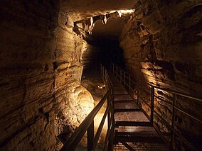
A solutional cave, solution cave, or karst cave is a cave usually formed in a soluble rock like limestone (Calcium carbonate CaCO3). It is the most frequently occurring type of cave. It can also form in other rocks, including chalk, dolomite, marble, salt beds, and gypsum.
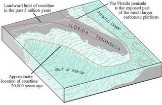
The Floridian peninsula is a porous plateau of karst limestone sitting atop bedrock known as the Florida Platform. The emergent portion of the platform was created during the Eocene to Oligocene as the Gulf Trough filled with silts, clays, and sands. Flora and fauna began appearing during the Miocene. No land animals were present in Florida prior to the Miocene.