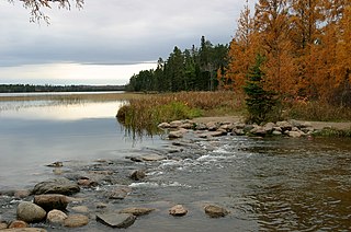
Itasca State Park is a state park of Minnesota, United States, and contains the headwaters of the Mississippi River. The park spans 32,690 acres (132.3 km2) of northern Minnesota, and is located about 21 miles (34 km) north of Park Rapids, Minnesota and 25 miles (40 km) from Bagley, Minnesota. The park is part of Minnesota's Pine Moraines and Outwash Plains Ecological Subsection and is contained within Clearwater, Hubbard, and Becker counties.

Hartwick Pines State Park is a public recreation area covering 9,762 acres (3,951 ha) in Crawford County near Grayling and Interstate 75 on the Lower Peninsula of the U.S. state of Michigan. The state park contains an old-growth forest of white pines and red pines, known as the Hartwick Pines. It is claimed by the Michigan Department of Natural resources that this old growth area, along with the Red Pine Natural Area Preserve in Roscommon County resembles the appearance of all Northern Michigan prior to the logging era. These areas do, however, lack the reoccurring low intensity fires which once occurred throughout northern Michigan, impacting regeneration of red pine and eastern hemlock, as well as leading to an increased content of hardwood species such as sugar maple and beech.

The Cloquet Valley State Forest encompasses 327,098 acres (1,323.7 km2); 48,384 acres (195.8 km2) of which are Minnesota Department of Natural Resources forestry administered lands.
The Beltrami Island State Forest is a state forest located in Lake of the Woods, Roseau, and Beltrami counties, Minnesota. Named after Italian explorer Giacomo Beltrami, it is the second-largest state forest in the Minnesota system after Pine Island State Forest. The largest wildlife management area in the state at 321,149 acres (129,964 ha), the Red Lake Wildlife Management Area, is located within the forest. The majority of the forest is managed by the Minnesota Department of Natural Resources, although a significant portion are tribal lands belonging to the neighboring Red Lake Band of Ojibwe.
The Foot Hills State Forest is a state forest located in Cass and Hubbard counties, Minnesota. The forest is a popular recreation spot due to its proximity to the greater Minneapolis – Saint Paul metropolitan area.
The Golden Anniversary State Forest is a state forest located near Grand Rapids in southern Itasca County, Minnesota. The forest was established in 1961 in celebration of the golden anniversary of the Minnesota Department of Natural Resources's Division of Forestry, which is responsible for the management of the majority of the state forests in Minnesota.

The Grand Portage State Forest is a state forest located near the community of Hovland in Cook County, in extreme northeastern Minnesota. The forest encloses Judge C. R. Magney State Park, Swamp River Wildlife Management Area, Hovland Woods Scientific and Natural Area, and Spring Beauty Hardwoods Scientific and Natural Area. It borders the Grand Portage Indian Reservation to the east, the Superior National Forest to the west, and Ontario to the north. The forest is named after the Grand Portage, a historic trade route between the Great Lakes and the Northwest.
The Jeanette State Forest is a state forest located in St. Louis County, Minnesota. The forest is within the limits of the Superior National Forest's Boundary Waters Canoe Area Wilderness, and thus falls under the federal jurisdiction and management of the United States Forest Service.
The Kabetogama State Forest is a state forest located in Koochiching and Saint Louis counties, Minnesota, United States. The forest borders the Superior National Forest and the Boundary Waters Canoe Area Wilderness to the east, the Sturgeon River State Forest to the south, the Nett Lake Indian Reservation to the west, and Voyageurs National Park to the north. The forest is managed by the Minnesota Department of Natural Resources.
The Koochiching State Forest is a state forest located near International Falls in Itasca, Koochiching, and Saint Louis counties, Minnesota. The forest borders the Pine Island State Forest to the west, the Big Fork State Forest and George Washington State Forest to the south, the Nett Lake Indian Reservation and the Kabetogama State Forest to the east. A leg of the forest touches Rainy Lake to the north, which forms part of the international border with Ontario. Of the 565,500 acres (2,288 km2), 344,300 acres (1,393 km2) are managed by the Minnesota Department of Natural Resources, making it one of the largest forests in the Minnesota state system.
The Lake of the Woods State Forest is a state forest located south of Lake of the Woods in Beltrami, Koochiching, Lake of the Woods and Roseau counties in Minnesota, USA. The forest borders the Pine Island State Forest to the east and the Beltrami Island State Forest to the west.
The Land o' Lakes State Forest is a state forest located primarily in Cass, Minnesota, with portions extending into adjacent Aitkin and Crow Wing counties. The forest has small shared borders with the Chippewa National Forest to the north, and the Hill River State Forest to east. Over half of the forest's land is managed by the Minnesota Department of Natural Resources; the remaining land is managed by Cass County or is privately held.
The Lost River State Forest is a state forest located in Roseau County, Minnesota. The forest borders the Canadian province of Manitoba to the north, and parcels belonging to the Red Lake Indian Reservation are within the forest's boundaries. The forest is managed by the Minnesota Department of Natural Resources.
The Mississippi Headwaters State Forest is a state forest located near the town of Wilton in Beltrami County, Minnesota. Portions of the forest extend into the neighboring counties of Clearwater and Hubbard. The majority of the forest is managed by the respective counties, with the Minnesota Department of Natural Resources managing around 9,000 acres (3,600 ha). The forest is named after its location immediately downstream (north) of Lake Itasca, the headwaters of the Mississippi River.

The Northwest Angle State Forest is a state forest located in Lake of the Woods County, Minnesota. The name of the forest is derived from its location near the Northwest Angle, the northernmost point of the contiguous United States. The forest borders the Canadian provinces of Manitoba and Ontario, and the Red Lake Indian Reservation. The forest is managed by the Minnesota Department of Natural Resources.
The Nemadji State Forest is a state forest located primarily in Pine County, Minnesota. A small portion of the forest extends into neighboring Carlton County. The eastern perimeter of the forest borders the state of Wisconsin. It is managed by the Minnesota Department of Natural Resources. Gray wolves, white-tailed deer, and eagles are present in the forest.
The Paul Bunyan State Forest is a state forest located in Hubbard and Cass counties in Minnesota. The forest borders the Chippewa National Forest and the Welsh Lake State Forest to the east, and the Mississippi Headwaters State Forest to the northwest. The forest is managed by the Minnesota Department of Natural Resources and the land department for Hubbard County.
The Pillsbury State Forest is a state forest located in Cass County, Minnesota. Created in 1900, it was the first designated Minnesota state forests. The forest borders Gull Lake and the city of Lake Shore to the north. The forest is managed by the Minnesota Department of Natural Resources. The name of the forest is derived from John S. Pillsbury, the former Governor of Minnesota, who donated the original 1,000 acres (4.0 km2) of land that became the state forest.
The Pine Island State Forest is a Minnesota state forest located primarily in Koochiching County, although there are portions that extend into Beltrami, Lake of the Woods, and Itasca counties. The forest borders the Koochiching State Forest to the east, the Red Lake State Forest to the west, and Big Fork State Forest and Chippewa National Forest to the south. At an area of 878,040 acres (355,330 ha), it is the largest state forest in Minnesota.
The Rum River State Forest is a state forest located in Kanabec, Mille Lacs and Morrison counties in central Minnesota. The forest is nearby the city of Onamia and is along the Rum River, just downstream (south) of Mille Lacs Lake. The forest is managed by the Minnesota Department of Natural Resources. The forest is home to many Northern hardwoods such as maple, oak, ash, elm and basswood that occupy most of the upland areas while tamarack and black spruce are found in lowland and marshy areas.
