
Trout Lake Township is located in north central Minnesota in Itasca County, United States. It is bordered by the City of Coleraine to the west and north, City of Bovey on the north, an unorganized township on the east, and Blackberry Township to the south. Town government was adopted on March 6, 1894. The population was 1,056 at the 2020 census.
Itasca State Park is a state park of Minnesota, United States, and contains the headwaters of the Mississippi River. The park spans 32,690 acres (132.3 km2) of northern Minnesota, and is located about 21 miles (34 km) north of Park Rapids, Minnesota and 25 miles (40 km) from Bagley, Minnesota. The park is part of Minnesota's Pine Moraines and Outwash Plains Ecological Subsection and is contained within Clearwater, Hubbard, and Becker counties.

Banning State Park is a state park of Minnesota, USA, stretched along 10 miles (16 km) of the Kettle River near Sandstone in Pine County. The centerpiece of the park is 1.5 miles (2.4 km) of churning rapids, some up to Class IV. The daring kayakers and canoeists who shoot Blueberry Slide, Mother's Delight, Dragon's Tooth, Little Banning, and Hell's Gate each spring attract spectators to the park. Landbound visitors can hike along the state's first Wild and Scenic River amid dramatic sandstone rock formations, large potholes carved by the river, and the remains of an historic quarry. Other features are Wolf Creek Falls and Robinson Ice Cave. The park is located directly off Interstate 35. Banning State Park is open daily from 8am until 10pm. Each vehicle entering the park requires an up to date permit which can be purchased online or at the park office.

Grand Portage State Park is a state park at the northeastern tip of the U.S. state of Minnesota, on the Canada–United States border. It contains a 120-foot (37 m) waterfall, the tallest in the state, on the Pigeon River. The High Falls and other waterfalls and rapids upstream necessitated a historically important portage on a fur trade route between the Great Lakes and inland Canada. This 8.5-mile (13.7 km) path as well as the sites of historic forts at either end are preserved in nearby Grand Portage National Monument.

Bear Head Lake State Park is a state park of Minnesota, United States, providing ready access to outdoor recreation in the Boundary Waters region. It boasts scenery similar to the nearby Boundary Waters Canoe Area Wilderness, with the added conveniences of road access, modern facilities, and motorboating. The most popular visitor activities are boating, fishing, swimming, and hiking. The park entirely surrounds 670-acre (270 ha) Bear Head Lake and three other fishing lakes. It was established in 1961 in Saint Louis County near Ely, Minnesota. The park also contains the woodlands surrounding the lakes, which gives an entire total of about 5,540 acres. The park also shares a large border with Bear Island State Forest.

Judge C. R. Magney State Park is a state park in the U.S. state of Minnesota, on the North Shore of Lake Superior. It was named for Clarence R. Magney, a former mayor of Duluth and justice of the Minnesota Supreme Court, who was instrumental in getting 11 state parks and scenic waysides established along the North Shore. The park is best known for the Devil's Kettle, an unusual waterfall and rock formation in which half of the Brule River disappears into a pothole.

St. Croix State Park is a state park in Pine County, Minnesota, USA. The park follows the shore of the St. Croix River for 21 miles (34 km) and contains the last 7 miles (11 km) of the Kettle River. At 33,895 acres (13,717 ha) it is the largest Minnesota state park. It was developed as a Recreational Demonstration Area in the 1930s, and is one of the finest surviving properties of this type in the nation. 164 structures built by the Civilian Conservation Corps and the Works Progress Administration survive, the largest collection of New Deal projects in Minnesota. As a historic district they were listed on the National Register of Historic Places and proclaimed a National Historic Landmark in 1997.

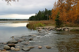
Lake Bemidji State Park is a state park of Minnesota, United States, on the north shore of 6,765-acre (27.38 km2) Lake Bemidji. The northern half of the park preserves a spruce-tamarack bog. A district of National Park Service rustic structures built by the Civilian Conservation Corps and National Youth Administration in the 1930s is on the National Register of Historic Places. The park is located 5 miles (8.0 km) north of the city of Bemidji.
The Taconite State Trail extends 165 miles from Grand Rapids, Minnesota to Ely, Minnesota and intersects the Arrowhead State Trail west of Lake Vermilion. On the Grand Rapids end, the trail is paved for the first 6 miles for in-line skating and biking. The rest of the trail is natural surface used primarily in the winter months for snowmobiling. In the summer, several areas contain standing water, but some areas are suitable for horseback riding, hiking, and mountain biking
The Beltrami Island State Forest is a state forest located in Lake of the Woods, Roseau, and Beltrami counties, Minnesota. Named after Italian explorer Giacomo Beltrami, it is the second-largest state forest in the Minnesota system after Pine Island State Forest. The largest wildlife management area in the state at 321,149 acres (129,964 ha), the Red Lake Wildlife Management Area, is located within the forest. The majority of the forest is managed by the Minnesota Department of Natural Resources, although a significant portion are tribal lands belonging to the neighboring Red Lake Band of Ojibwe.
The Foot Hills State Forest is a state forest located in Cass and Hubbard counties, Minnesota. The forest is a popular recreation spot due to its proximity to the greater Minneapolis – Saint Paul metropolitan area.
The General C. C. Andrew State Forest is a state forest located in Pine County, Minnesota. The forest is named in honor of major general Christopher Columbus Andrews, a Civil War veteran, and an early Minnesota state Forestry Commissioner and proponent for scientific forestry and forest management. The Minnesota Department of Natural Resources manages the majority of the forest.
The Golden Anniversary State Forest is a state forest located near Grand Rapids in southern Itasca County, Minnesota. The forest was established in 1961 in celebration of the golden anniversary of the Minnesota Department of Natural Resources's Division of Forestry, which is responsible for the management of the majority of the state forests in Minnesota.
The Huntersville State Forest is a state forest located in Wadena County, Minnesota. Around half of the forest is managed by the Minnesota Department of Natural Resources, with the other half controlled privately.
The Land o' Lakes State Forest is a state forest located primarily in Cass, Minnesota, with portions extending into adjacent Aitkin and Crow Wing counties. The forest has small shared borders with the Chippewa National Forest to the north, and the Hill River State Forest to east. Over half of the forest's land is managed by the Minnesota Department of Natural Resources; the remaining land is managed by Cass County or is privately held.
The Lyons State Forest is a state forest located near the city of Staples in Wadena County, Minnesota. The forest is managed by the Minnesota Department of Natural Resources.
The Mississippi Headwaters State Forest is a state forest located near the town of Wilton in Beltrami County, Minnesota. Portions of the forest extend into the neighboring counties of Clearwater and Hubbard. The majority of the forest is managed by the respective counties, with the Minnesota Department of Natural Resources managing around 9,000 acres (3,600 ha). The forest is named after its location immediately downstream (north) of Lake Itasca, the headwaters of the Mississippi River.
The Nemadji State Forest is a state forest located primarily in Pine County, Minnesota. A small portion of the forest extends into neighboring Carlton County. The eastern perimeter of the forest borders the state of Wisconsin. It is managed by the Minnesota Department of Natural Resources. Gray wolves, white-tailed deer, and eagles are present in the forest.
The Pine Island State Forest is a Minnesota state forest located primarily in Koochiching County, although there are portions that extend into Beltrami, Lake of the Woods, and Itasca counties. The forest borders the Koochiching State Forest to the east, the Red Lake State Forest to the west, and Big Fork State Forest and Chippewa National Forest to the south. At an area of 878,040 acres (355,330 ha), it is the largest state forest in Minnesota.
Minnesota Scenic Byways are a system of roads in the U.S. state of Minnesota which pass through areas of scenic, cultural, or recreational significance. There are currently 22 scenic byways in the system with a total length of 2,948 miles (4,744 km). Eight of these byways are also designated as National Scenic Byways, and the North Shore Scenic Drive is further designated as an All-American Road.
