Lac qui Parle

Last updated
Lac qui Parle
LacQui.jpg
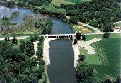
Dam located on the southern tip.
Source: US Army Corps of Engineers
USA Minnesota relief location map.svg
Red pog.svg
Lac qui Parle
Usa edcp relief location map.png
Red pog.svg
Lac qui Parle
Location Chippewa County, Lac qui Parle County and Swift County, Minnesota United States
Coordinates 45°6′N95°59′W / 45.100°N 95.983°W / 45.100; -95.983
Type reservoir
Primary inflows Minnesota River
Primary outflows Minnesota River
Basin  countriesUnited States

Lac qui Parle is a lake located in western Minnesota, United States, which was widened by the damming of the Minnesota River. The dam was built by the Works Progress Administration (WPA) in 1939. It was reconstructed in 1996. Lac qui Parle is a French translation of the native Dakota name, meaning "lake which speaks". [1] [2]

Contents

The northernmost point of the lake is about 3 miles southeast of the city of Appleton. The lake flows 10 miles southeast to the dam, which is about 4 miles to the west of the town of Watson.

Lac qui Parle State Park is located on the southern portion of the lake. Lac qui Parle serves as a temporary home of thousands of migratory Canada geese and other waterfowl.

See also

Related Research Articles

<span class="mw-page-title-main">Yellow Medicine County, Minnesota</span> County in Minnesota, United States

Yellow Medicine County is a county in the southwestern part of the U.S. state of Minnesota. Its eastern border is formed by the Minnesota River. As of the 2020 census, the population was 9,528. Its county seat is Granite Falls.

<span class="mw-page-title-main">Lac qui Parle County, Minnesota</span> County in Minnesota, United States

Lac qui Parle County is a county in the southwestern part of the U.S. state of Minnesota. As of the 2020 census, the population was 6,719. Its county seat is Madison. The largest city in the county is Dawson.

<span class="mw-page-title-main">Chippewa County, Minnesota</span> County in Minnesota, United States

Chippewa County is a county in the U.S. state of Minnesota. As of the 2020 census, the population was 12,598. Its county seat is Montevideo. The county was formed in 1862, and was organized in 1868.

<span class="mw-page-title-main">Big Stone County, Minnesota</span> County in Minnesota, United States

Big Stone County is a county in the U.S. state of Minnesota. As of the 2020 census, the population was 5,166. Its county seat is Ortonville.

Akron Township is a township in Big Stone County, Minnesota, United States. The population was 196 as of the 2000 census.

Odessa Township is a township in Big Stone County, Minnesota, United States. The population was 147 as of the 2000 census. Odessa Township was named after Odesa, Ukraine.

<span class="mw-page-title-main">Dawson, Minnesota</span> City in Minnesota, United States

Dawson is a city in Lac qui Parle County, Minnesota, United States. The population was 1,466 at the 2020 census.

Lac qui Parle Township is a township in Lac qui Parle County, Minnesota, United States. The population was 183 at the 2000 census.

<span class="mw-page-title-main">Madison, Minnesota</span> City in Minnesota, United States

Madison is a city in Lac qui Parle County, Minnesota, United States, along the 45th parallel. The population was 1,518 at the 2020 census. It is the county seat of Lac qui Parle County. It proclaims itself to be the "lutefisk capital of the USA."

Maxwell Township is a township in Lac qui Parle County, Minnesota, United States. The population was 206 at the 2000 census.

Providence Township is a township in Lac qui Parle County, Minnesota, United States. The population was 186 at the 2000 census.

<span class="mw-page-title-main">Appleton, Minnesota</span> City in Minnesota, United States

Appleton is a city in Swift County, Minnesota, United States. Its population was 1,412 at the 2010 census. The town is home to a vacant medium-security prison, the Prairie Correctional Facility, which is wholly owned and operated by Corrections Corporation of America. Appleton also includes a plant-protein factory operated by Eat Just, Inc.

<span class="mw-page-title-main">Lake of the Woods</span> Lake on the United States–Canada border

Lake of the Woods is a lake occupying parts of the Canadian provinces of Ontario and Manitoba and the U.S. state of Minnesota. Lake of the Woods is over 70 miles (110 km) long and wide, containing more than 14,552 islands and 65,000 miles (105,000 km) of shoreline. It is fed by the Rainy River, Shoal Lake, Kakagi Lake and other smaller rivers. The lake drains into the Winnipeg River and then into Lake Winnipeg. Ultimately, its outflow goes north through the Nelson River to Hudson Bay.

Ten Mile Lake or Tenmile Lake may refer to:

<span class="mw-page-title-main">Lac qui Parle River</span> River in Minnesota, United States

The Lac qui Parle River is a tributary of the Minnesota River, 118 miles (190 km) long, in southwestern Minnesota in the United States. A number of tributaries of the river, including its largest, the West Branch Lac qui Parle River, also flow in eastern South Dakota. Via the Minnesota River, the Lac qui Parle River is part of the watershed of the Mississippi River, draining an area of 1,156 square miles (2,990 km2) in an agricultural region. Slightly more than two-thirds of the Lac qui Parle watershed is in Minnesota. Lac qui parle means "lake which speaks" in the French language, and was a translation of the Sioux name for Lac qui Parle, a lake on the Minnesota River upstream of the mouth of the Lac qui Parle River.

<span class="mw-page-title-main">Lac qui Parle State Park</span> United States historic place

Lac qui Parle State Park is a state park of Minnesota, United States, near Watson. Lac qui Parle is a French translation of the native Dakota name, meaning "talking lake".

<span class="mw-page-title-main">Minnesota State Highway 40</span> State highway in Minnesota, United States

Minnesota State Highway 40 (MN 40) is a 72.723-mile-long (117.036 km) state highway in west-central Minnesota, which travels from South Dakota Highway 20 (SD 20) at the South Dakota state line near Marietta and continues east to its eastern terminus at its intersection with County State-Aid Highway 5 (CSAH 5) in Willmar.

<span class="mw-page-title-main">Big Stone National Wildlife Refuge</span> National wildlife refuge in Minnesota, United States

Straddling the headwaters of the Minnesota River in west-central Minnesota, Big Stone National Wildlife Refuge is within the heart of the tallgrass prairie's historic range. Today, less than one-percent of tallgrass prairie remains.

<span class="mw-page-title-main">National Register of Historic Places listings in Lac qui Parle County, Minnesota</span>

This is a list of the National Register of Historic Places listings in Lac qui Parle County, Minnesota. It is intended to be a complete list of the properties and districts on the National Register of Historic Places in Lac qui Parle County, Minnesota, United States. The locations of National Register properties and districts for which the latitude and longitude coordinates are included below, may be seen in an online map.

<span class="mw-page-title-main">Lac qui Parle Mission</span> United States historic place

Lac qui Parle Mission is a pre-territorial mission in Chippewa County, Minnesota, United States, which was founded in June 1835 by Dr. Thomas Smith Williamson and Alexander Huggins after fur trader Joseph Renville invited missionaries to the area. Lac qui Parle is a French translation of the native Dakota name, meaning "lake which speaks". In the 19th century, the first dictionary of the Dakota language was written, and part of the Bible was translated into that language for the first time at a mission on the site of the park. It was a site for Christian missionary work to the Sioux for nearly 20 years. Renville was related to and had many friends in the Native community, and after his death in 1846, the mission was taken over by the "irreligious" Martin McLeod. The relationship between the mission and the Dakota people worsened, and in 1854 the missionaries abandoned the site and relocated to the Upper Sioux Agency.

References

  1. Gannett, Henry (1905). The Origin of Certain Place Names in the United States. Government Printing Office. pp.  178.
  2. "Lac qui Parle State Park".