Sacred Heart, Minnesota

Last updated
Sacred Heart
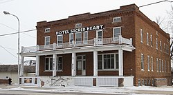
2018HotelSacredHeart.jpg
Renville County Minnesota Incorporated and Unincorporated areas Sacred Heart Highlighted.svg
Location of Sacred Heart, Minnesota
Coordinates: 44°47′12″N95°21′6″W / 44.78667°N 95.35167°W / 44.78667; -95.35167
Country United States
State Minnesota
County Renville
Area
[1]
  Total0.99 sq mi (2.57 km2)
  Land0.99 sq mi (2.57 km2)
  Water0.00 sq mi (0.00 km2)
Elevation
[2]
1,073 ft (327 m)
Population
 (2020)
  Total510
  Density514.11/sq mi (198.44/km2)
Time zone UTC-6 (Central (CST))
  Summer (DST) UTC-5 (CDT)
ZIP code
56285
Area code 320
FIPS code 27-56572 [3]
GNIS feature ID0650451 [2]

Sacred Heart is a city in Renville County, Minnesota, United States. The population was 548 at the 2010 census. [4]

Contents

History

Sacred Heart was platted in 1878. [5] The 1914 Hotel Sacred Heart is listed on the National Register of Historic Places.

Geography

According to the United States Census Bureau, the city has a total area of 0.99 square miles (2.56 km2), all land. [6] It is the westernmost town in Renville County.

U.S. Route 212 serves as a main route in the community.

Demographics

Historical population
CensusPop.Note
1880 76
1890 327330.3%
1900 53864.5%
1910 5879.1%
1920 76330.0%
1930 685−10.2%
1940 7529.8%
1950 745−0.9%
1960 696−6.6%
1970 7071.6%
1980 666−5.8%
1990 603−9.5%
2000 549−9.0%
2010 548−0.2%
2020 510−6.9%
U.S. Decennial Census [7]

2010 census

As of the census [8] of 2010, there were 548 people, 235 households, and 139 families living in the city. The population density was 553.5 inhabitants per square mile (213.7/km2). There were 282 housing units at an average density of 284.8 per square mile (110.0/km2). The racial makeup of the city was 98.5% White, 0.2% African American, 0.9% Native American, and 0.4% from other races. Hispanic or Latino of any race were 9.1% of the population.

There were 235 households, of which 29.4% had children under the age of 18 living with them, 42.1% were married couples living together, 9.8% had a female householder with no husband present, 7.2% had a male householder with no wife present, and 40.9% were non-families. 35.7% of all households were made up of individuals, and 19.2% had someone living alone who was 65 years of age or older. The average household size was 2.33 and the average family size was 3.08.

The median age in the city was 36.6 years. 26.3% of residents were under the age of 18; 6.8% were between the ages of 18 and 24; 24.2% were from 25 to 44; 24.8% were from 45 to 64; and 17.9% were 65 years of age or older. The gender makeup of the city was 48.5% male and 51.5% female.

2000 census

As of the census [3] of 2000, there were 549 people, 246 households, and 147 families living in the city. The population density was 553.2 inhabitants per square mile (213.6/km2). There were 290 housing units at an average density of 292.2 per square mile (112.8/km2). The racial makeup of the city was 97.45% White, 0.18% Native American, 1.46% from other races, and 0.91% from two or more races. Hispanic or Latino of any race were 7.10% of the population.

There were 246 households, out of which 24.0% had children under the age of 18 living with them, 51.6% were married couples living together, 6.1% had a female householder with no husband present, and 40.2% were non-families. 36.6% of all households were made up of individuals, and 18.7% had someone living alone who was 65 years of age or older. The average household size was 2.23 and the average family size was 2.94.

In the city, the population was spread out, with 24.6% under the age of 18, 7.1% from 18 to 24, 23.0% from 25 to 44, 23.3% from 45 to 64, and 22.0% who were 65 years of age or older. The median age was 42 years. For every 100 females, there were 87.4 males. For every 100 females age 18 and over, there were 84.8 males.

The median income for a household in the city was $32,333, and the median income for a family was $40,313. Males had a median income of $28,654 versus $22,019 for females. The per capita income for the city was $18,089. About 5.4% of families and 10.9% of the population were below the poverty line, including 21.0% of those under age 18 and none of those age 65 or over.
Recreation

Sacred Heart has a state of the art baseball complex where the local Saints team plays baseball. Next door to the baseball field is an outdoor ice skating rink maintained in the winter months.

There is one primary park in town that has tennis courts available, along with a picnic pavilion, cooking grills and playgrounds for children.

Notable people

Noted people from Sacred Heart have included Ole Ramsland, a former member of the Minnesota House of Representatives, [9] and his son Max Ramsland, who later moved to Canada and was elected as a member of the Legislative Assembly of Saskatchewan. Alpha Sunde Smaby, a former member of the Minnesota House of Representatives was born in Sacred Heart. [10]

Related Research Articles

<span class="mw-page-title-main">Renville County, Minnesota</span> County in Minnesota, United States

Renville County is a county in the U.S. state of Minnesota. As of the 2020 census the population was 14,723. Its county seat is Olivia.

Burlington Township is a township in Becker County, Minnesota, United States. The population was 1,545 as of the 2010 census.

<span class="mw-page-title-main">Waconia, Minnesota</span> City in Minnesota, United States

Waconia is a city in Carver County, Minnesota, United States. Waconia attracts visitors to nearby Lake Waconia, a lake locally renowned for its fishing and recreation opportunities.

<span class="mw-page-title-main">Emily, Minnesota</span> City in Minnesota, United States

Emily is a city in Crow Wing County, Minnesota, United States. The population was 813 at the 2010 census. It is part of the Brainerd Micropolitan Statistical Area.

<span class="mw-page-title-main">Coleraine, Minnesota</span> City in Minnesota, United States

Coleraine is a city in Itasca County, Minnesota, United States. The population was 1,970 at the 2010 census. The community was named after Thomas F. Cole, President of the Oliver Iron Mining Company.

<span class="mw-page-title-main">Lake Bronson, Minnesota</span> City in Minnesota, United States

Lake Bronson is a city in Kittson County, Minnesota, United States. The population was 178 at the 2020 census. Lake Bronson State Park is nearby.

<span class="mw-page-title-main">Halstad, Minnesota</span> City in Minnesota, United States

Halstad is a city in Norman County, Minnesota. The population was 564 at the time of the 2020 census. The city is known for its production of sugar beets, and has a statue of a sugar beet, known as the world's largest sugar beet, to commemorate this status.

Beaver Falls Township is a township in Renville County, Minnesota, United States. The population was 331 at the 2000 census.

Boon Lake Township is a township in Renville County, Minnesota, United States. The population was 400 at the 2000 census.

<span class="mw-page-title-main">Buffalo Lake, Minnesota</span> City in Minnesota, United States

Buffalo Lake is a city in Renville County, Minnesota, United States. The population was 733 at the 2010 census.

<span class="mw-page-title-main">Danube, Minnesota</span> City in Minnesota, United States

Danube is a city in Renville County, Minnesota, United States. The population was 505 at the 2010 census.

<span class="mw-page-title-main">Fairfax, Minnesota</span> City in Minnesota, United States

Fairfax is a city in Renville County, Minnesota, United States. The population was 1,235 at the 2010 census.

<span class="mw-page-title-main">Franklin, Minnesota</span> City in Minnesota, United States

Franklin is a city in Renville County, Minnesota, United States. The population was 510 at the 2010 census.

<span class="mw-page-title-main">Morton, Minnesota</span> City in Minnesota, United States

Morton is a city in Renville County, Minnesota, United States. This city is ninety-five miles southwest of Minneapolis. It is the administrative headquarters of the Lower Sioux Indian Reservation. The population was 411 at the 2010 census.

<span class="mw-page-title-main">Olivia, Minnesota</span> City in Minnesota, United States

Olivia is the county seat of Renville County, Minnesota, United States. Its population was 2,484 at the 2010 census.

<span class="mw-page-title-main">Renville, Minnesota</span> City in Minnesota, United States

Renville is a city in Renville County, Minnesota, United States. The population was 1,287 at the 2010 census.

Sacred Heart Township is a township in Renville County, Minnesota, United States. The population was 277 at the 2000 census.

<span class="mw-page-title-main">Bird Island, Minnesota</span> City in Minnesota, United States

Bird Island is a city located on U.S. Route 212 in Renville County, Minnesota, United States. The population was 1,005 at the 2020 census.

<span class="mw-page-title-main">Bellechester, Minnesota</span> City in Minnesota, United States

Bellechester is a city in Goodhue and Wabasha counties in the U.S. state of Minnesota. The population was 175 at the 2010 census. Most of Bellchester is in Goodhue County, with only a small part extending into Wabasha County.

Olive Branch is an unincorporated census-designated place in Alexander County, Illinois, United States. It has a post office with the ZIP code 62969. Its population was 650 at the 2020 census.

References

  1. "2020 U.S. Gazetteer Files". United States Census Bureau. Retrieved July 24, 2022.
  2. 1 2 U.S. Geological Survey Geographic Names Information System: Sacred Heart, Minnesota
  3. 1 2 "U.S. Census website". United States Census Bureau . Retrieved 2008-01-31.
  4. "2010 Census Redistricting Data (Public Law 94-171) Summary File". American FactFinder. United States Census Bureau . Retrieved 27 April 2011.[ dead link ]
  5. Upham, Warren (1920). Minnesota Geographic Names: Their Origin and Historic Significance. Minnesota Historical Society. p.  459.
  6. "US Gazetteer files 2010". United States Census Bureau. Archived from the original on 2012-07-02. Retrieved 2012-11-13.
  7. "Census of Population and Housing". Census.gov. Retrieved June 4, 2015.
  8. "U.S. Census website". United States Census Bureau . Retrieved 2012-11-13.
  9. Franklyn Curtiss-Wedge, History of Renville County Minnesota, Vol. 1. H. C. Cooper Jr, & Co., Chicago (1916).
  10. Minnesota Legislators Past and Present-Alpha Sunde Smaby

Coordinates: 44°47′13″N95°21′06″W / 44.78694°N 95.35167°W / 44.78694; -95.35167