Franklin, Minnesota

Last updated

Franklin
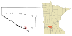
Renville County Minnesota Incorporated and Unincorporated areas Franklin Highlighted.svg
Location of Franklin, Minnesota
Coordinates: 44°31′50″N94°53′03″W / 44.53056°N 94.88417°W / 44.53056; -94.88417
Country United States
State Minnesota
County Renville
Area
[1]
  Total
1.00 sq mi (2.60 km2)
  Land1.00 sq mi (2.60 km2)
  Water0.00 sq mi (0.00 km2)
Elevation
[2]
1,011 ft (308 m)
Population
 (2020)
  Total
493
  Density490.55/sq mi (189.34/km2)
Time zone UTC-6 (Central (CST))
  Summer (DST) UTC-5 (CDT)
ZIP code
55333
Area code 507
FIPS code 27-22364 [3]
GNIS feature ID2394809 [2]

Franklin is a city in Renville County, Minnesota, United States. The population was 510 at the 2010 census. [4]

Contents

History

Franklin was platted in 1882. [5] The city was named for Benjamin Franklin. [6]

The 1862 Battle of Redwood Ferry took place just outside what would later become the town of Franklin. [7]

Geography

According to the United States Census Bureau, the city has a total area of 1.08 square miles (2.80 km2), all land. [8]

Franklin is located on Minnesota State Highway 19, east of U.S. Route 71.

Demographics

Historical population
CensusPop.Note
1890 284
1900 43954.6%
1910 4390.0%
1920 51016.2%
1930 5354.9%
1940 502−6.2%
1950 5468.8%
1960 5480.4%
1970 5571.6%
1980 512−8.1%
1990 441−13.9%
2000 49812.9%
2010 5102.4%
2020 493−3.3%
U.S. Decennial Census [9]

2010 census

As of the census [10] of 2010, there were 510 people, 207 households, and 120 families living in the city. The population density was 472.2 inhabitants per square mile (182.3/km2). There were 230 housing units at an average density of 213.0 per square mile (82.2/km2). The racial makeup of the city was 93.1% White, 0.2% African American, 1.4% Native American, 1.6% Asian, and 3.7% from two or more races. Hispanic or Latino of any race were 1.8% of the population.

There were 207 households, of which 28.5% had children under the age of 18 living with them, 41.5% were married couples living together, 12.1% had a female householder with no husband present, 4.3% had a male householder with no wife present, and 42.0% were non-families. 38.2% of all households were made up of individuals, and 20.3% had someone living alone who was 65 years of age or older. The average household size was 2.24 and the average family size was 2.98.

The median age in the city was 47.1 years. 24.5% of residents were under the age of 18; 6% were between the ages of 18 and 24; 15.8% were from 25 to 44; 32.1% were from 45 to 64; and 21.6% were 65 years of age or older. The gender makeup of the city was 49.4% male and 50.6% female.

2000 census

As of the census [3] of 2000, there were 498 people, 195 households, and 124 families living in the city. The population density was 458.6 inhabitants per square mile (177.1/km2). There were 217 housing units at an average density of 199.8 per square mile (77.1/km2). The racial makeup of the city was 96.39% White, 1.00% Native American, 1.20% from other races, and 1.41% from two or more races. Hispanic or Latino of any race were 1.41% of the population.

There were 195 households, out of which 30.3% had children under the age of 18 living with them, 54.4% were married couples living together, 7.7% had a female householder with no husband present, and 36.4% were non-families. 33.8% of all households were made up of individuals, and 17.4% had someone living alone who was 65 years of age or older. The average household size was 2.37 and the average family size was 3.07.

In the city, the population was spread out, with 26.1% under the age of 18, 4.6% from 18 to 24, 23.5% from 25 to 44, 18.5% from 45 to 64, and 27.3% who were 65 years of age or older. The median age was 43 years. For every 100 females, there were 93.8 males. For every 100 females age 18 and over, there were 86.8 males.

The median income for a household in the city was $37,583, and the median income for a family was $40,417. Males had a median income of $32,500 versus $19,659 for females. The per capita income for the city was $16,212. About 5.2% of families and 9.0% of the population were below the poverty line, including 10.8% of those under age 18 and 7.0% of those age 65 or over.
Attractions

Catfish Derby Days is an annual three-day city celebration held on the fourth weekend in July. Events include a contest to catch the biggest catfish, a street dance, Sunday parades, a coed volleyball tournament, a men's 12-team softball tournament, a beanbag tournament, a queen contest/variety show, a chess tournament, a "Kiss the Catfish Contest," music at the park, a raffle, church services, a fire department water ball, and a St. Luke's Lutheran Church-sponsored breakfast. [11] [12]

Related Research Articles

<span class="mw-page-title-main">Backus, Minnesota</span> City in Minnesota, United States

Backus is a city in Cass County, Minnesota, United States. The population was 262 at the 2020 census. It is part of the Brainerd Micropolitan Statistical Area.

<span class="mw-page-title-main">Chickamaw Beach, Minnesota</span> City in Minnesota, United States

Chickamaw Beach is a city in Cass County, Minnesota, United States. The population was 128 at the 2020 census. It is part of the Brainerd Micropolitan Statistical Area.

<span class="mw-page-title-main">Lake Shore, Minnesota</span> City in Minnesota, United States

Lake Shore is a city in Cass County, Minnesota, United States. The population was 1,056 at the 2020 census. It is part of the Brainerd Micropolitan Statistical Area.

<span class="mw-page-title-main">Hitterdal, Minnesota</span> City in Minnesota, United States

Hitterdal is a city in Clay County, Minnesota, United States. The population was 199 at the 2020 census.

<span class="mw-page-title-main">Lake Bronson, Minnesota</span> City in Minnesota, United States

Lake Bronson is a city in Kittson County, Minnesota, United States. The population was 178 at the 2020 census. Lake Bronson State Park is nearby.

<span class="mw-page-title-main">Lastrup, Minnesota</span> City in Minnesota, United States

Lastrup is a city in Morrison County, Minnesota, United States. The population was 120 at the 2020 census.

<span class="mw-page-title-main">Deer Creek, Minnesota</span> City in Minnesota, United States

Deer Creek is a city in Otter Tail County, Minnesota, United States. The population was 330 at the 2020 census.

<span class="mw-page-title-main">Erhard, Minnesota</span> City in Minnesota, United States

Erhard is a city in Otter Tail County, Minnesota, United States. The population was 132 at the 2020 census.

<span class="mw-page-title-main">Henning, Minnesota</span> City in Minnesota, United States

Henning is a city in Otter Tail County, Minnesota, United States. The population was 854 at the 2020 census.

<span class="mw-page-title-main">Ottertail, Minnesota</span> City in Minnesota, United States

Ottertail is a city in Otter Tail County, Minnesota, United States. The population was 629 at the 2020 census.

<span class="mw-page-title-main">Richville, Minnesota</span> City in Minnesota, United States

Richville is a city in Otter Tail County, Minnesota, United States. The population was 77 as of the 2020 census.

<span class="mw-page-title-main">Urbank, Minnesota</span> City in Minnesota, United States

Urbank is a city in Otter Tail County, Minnesota, United States. The population was 52 at the 2020 census.

<span class="mw-page-title-main">Maplewood, Minnesota</span> City in Minnesota, United States

Maplewood is a city in Ramsey County, Minnesota, United States. The population was 42,088 at the 2020 census. Maplewood is ten minutes' drive from downtown Saint Paul. It stretches along the northern and eastern borders of Saint Paul.

Franklin Township is a rural township in Wright County, Minnesota, United States. The township population was 2,774 at the 2000 census.

<span class="mw-page-title-main">Fifty Lakes, Minnesota</span> City in Minnesota, United States

Fifty Lakes is a city in Crow Wing County, Minnesota, United States. The population was 387 at the 2010 census. It is part of the Brainerd Micropolitan Statistical Area.

<span class="mw-page-title-main">Lansford, North Dakota</span> City in North Dakota, United States

Lansford is a city in Bottineau County, North Dakota, United States. The population was 238 at the 2020 census. Lansford was founded in 1903.

<span class="mw-page-title-main">Franklin Township, Susquehanna County, Pennsylvania</span> Township in Pennsylvania, United States

Franklin Township is a township in Susquehanna County, Pennsylvania, United States. The population was 833 at the 2020 census. Salt Springs State Park, a Pennsylvania state park, is in Franklin Township.

<span class="mw-page-title-main">St. Anthony, Stearns County, Minnesota</span> City in Minnesota, United States

St. Anthony or Saint Anthony is a city in Stearns County, Minnesota, United States. The population was 91 at the 2020 census. It is part of the St. Cloud Metropolitan Statistical Area. Main routes include Minnesota State Highway 238, Stearns County Road 153, and Trobec Street.

<span class="mw-page-title-main">Minnesota Lake, Minnesota</span> City in Minnesota, United States

Minnesota Lake is a city in Blue Earth and Faribault counties in the State of Minnesota. The population was 661 at the 2020 census. The bulk of the city is in Faribault County; a small part extends into Blue Earth County.

<span class="mw-page-title-main">Dennison, Minnesota</span> City in Minnesota, United States

Dennison is a city in Goodhue and Rice counties in the U.S. state of Minnesota. The population was 212 at the 2010 census. Most of Dennison is in Goodhue County, with only a small part that extends into Rice County.

References

  1. "2020 U.S. Gazetteer Files". United States Census Bureau. Retrieved July 24, 2022.
  2. 1 2 U.S. Geological Survey Geographic Names Information System: Franklin, Minnesota
  3. 1 2 "U.S. Census website". United States Census Bureau . Retrieved January 31, 2008.
  4. "2010 Census Redistricting Data (Public Law 94-171) Summary File". American FactFinder. United States Census Bureau . Retrieved April 27, 2011.[ dead link ]
  5. Upham, Warren (1920). Minnesota Geographic Names: Their Origin and Historic Significance. Minnesota Historical Society. p. 457.
  6. Lowthian, M. Russ (September 1, 2006). Road Biking Minnesota: A Guide to the Greatest Bike Rides in Minnesota. Globe Pequot Press. p. 88. ISBN   978-0-7627-3801-4.
  7. "Redwood Ferry Historical Marker". www.hmdb.org. Retrieved May 11, 2023.
  8. "US Gazetteer files 2010". United States Census Bureau. Archived from the original on July 2, 2012. Retrieved November 13, 2012.
  9. "Census of Population and Housing". Census.gov. Retrieved June 4, 2015.
  10. "U.S. Census website". United States Census Bureau . Retrieved November 13, 2012.
  11. "Catfish Days".
  12. "Franklin, MN - Catfish Capital of Minnesota".