
Prairies are ecosystems considered part of the temperate grasslands, savannas, and shrublands biome by ecologists, based on similar temperate climates, moderate rainfall, and a composition of grasses, herbs, and shrubs, rather than trees, as the dominant vegetation type. Temperate grassland regions include the Pampas of Argentina, Brazil and Uruguay, and the steppe of Ukraine, Russia, and Kazakhstan. Lands typically referred to as "prairie" tend to be in North America. The term encompasses the area referred to as the Interior Lowlands of Canada, the United States, and Mexico, which includes all of the Great Plains as well as the wetter, hillier land to the east.

Sherburne County is a county in Central Minnesota. At the 2020 census, the population was 97,183. The county seat is Elk River.

Rice County is a county located in the south central portion of the U.S. state of Minnesota. As of the 2020 census, the population was 67,097. Its county seat is Faribault.

The Kankakee River is a tributary of the Illinois River, approximately 133 miles (214 km) long, in the Central Corn Belt Plains of northwestern Indiana and northeastern Illinois in the United States. At one time, the river drained one of the largest wetlands in North America and furnished a significant portage between the Great Lakes and the Mississippi River. Significantly altered from its original channel, it flows through a primarily rural farming region of reclaimed cropland, south of Lake Michigan.

An oak savanna is a type of savanna—or lightly forested grassland—where oaks are the dominant trees. The terms "oakery" or "woodlands" are also used commonly, though the former is more prevalent when referencing the Mediterranean area. These savannas were maintained historically through wildfires set by lightning, humans, grazing, low precipitation, and/or poor soil.

The Driftless Area, also known as Bluff Country and the Paleozoic Plateau, is a topographical and cultural region in the Midwestern United States that comprises southwestern Wisconsin, southeastern Minnesota, northeastern Iowa, and the extreme northwestern corner of Illinois. The Driftless Area is a USDA Level III Ecoregion: Ecoregion 52. The Driftless Area takes up a large portion of the Upper Midwest forest–savanna transition. The Blufflands refers to the eastern section of the Driftless area in Minnesota, due to the steep bluffs and cliffs around the river valleys. The western half is known as the Rochester Plateau, which is flatter than the Blufflands. The Coulee Region refers to the southwestern part of the Driftless Area in Wisconsin. It is named for its numerous ravines.

Savanna Portage State Park is a state park in the U.S. State of Minnesota established in 1961 to preserve the historic Savanna Portage, a difficult 6-mile (9.7 km) trail connecting the watersheds of the Mississippi River and Lake Superior. The portage trail crosses a drainage divide separating the West Savanna River, which drains to the Mississippi River and the Gulf of Mexico, from the East Savanna River, which flows in an opposite direction to the Saint Louis River, Lake Superior and the Great Lakes, and the Saint Lawrence River to the Atlantic Ocean.
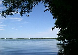
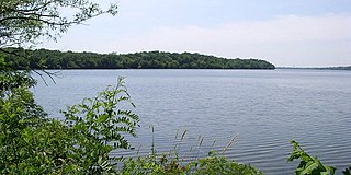
Myre-Big Island State Park is a state park of Minnesota, USA, just outside the city of Albert Lea. It has an area of 1,578 acres (6.39 km2). The park protects 8 miles (13 km) of shoreline on Albert Lea Lake. The nucleus of the park is Big Island, a 117-acre (0.47 km2) island attached to the mainland by a causeway. In turn a causeway connects Big Island to Little Island. The park was formerly named Helmer Myre State Park after former Minnesota State Senator Helmer Myre.

Minneopa State Park is a state park in the U.S. state of Minnesota. It was established in 1905 to preserve Minneopa Falls, a large waterfall for southern Minnesota, and was expanded in the 1960s to include the lower reaches of Minneopa Creek and a large tract of prairie. Minneopa is Minnesota's third oldest state park, after Itasca and Interstate. Two park resources are listed on the National Register of Historic Places: the 1862 Seppman Mill and a district of seven Rustic Style structures built by the Works Progress Administration in the late 1930s. The park is located almost entirely on the south side of the Minnesota River, three miles (4.8 km) west of Mankato. In 2015 the state reintroduced American bison to the park in a 330-acre (130 ha) fenced enclosure, through which visitors can drive in their vehicles.

Nerstrand-Big Woods State Park is a state park of Minnesota, US, northeast of Faribault just outside the small town of Nerstrand. The park derives its name from the Big Woods, a large, contiguous forested area covering much of southeast Minnesota prior to the 1840s, when European settlers began to establish farms in the territory, and from Nedstrand in Tysvær, Norway, of which Nerstrand is a namesake. The park and its forest were an outlying 'woods' typical of and similar to the Big Woods proper, which were historically found on the more recent glacier deposits located west of the Cannon River 10 miles (16 km) to the west. Aside from a small waterfall, the outstanding natural feature of the park is the forest itself.
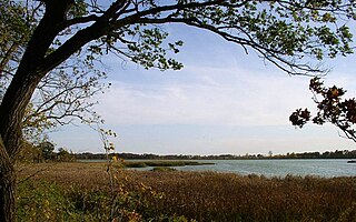
Rice Lake State Park is a state park of Minnesota, United States, just east of Owatonna. Park lands entirely surround Rice Lake, an important stopping point for migrating waterfowl. The lake covers 750 acres (300 ha) with an average depth of three feet (1 m).

St. Croix State Park is a state park in Pine County, Minnesota, USA. The park follows the shore of the St. Croix River for 21 miles (34 km) and contains the last 7 miles (11 km) of the Kettle River. At 33,895 acres (13,717 ha) it is the largest Minnesota state park. It was developed as a Recreational Demonstration Area in the 1930s, and is one of the finest surviving properties of this type in the nation. 164 structures built by the Civilian Conservation Corps and the Works Progress Administration survive, the largest collection of New Deal projects in Minnesota. As a historic district they were listed on the National Register of Historic Places and proclaimed a National Historic Landmark in 1997.
Sakatah Lake State Park is an 842-acre (341 ha) state park of Minnesota, USA, on a natural widening of the Cannon River near the town of Waterville. The Dakota native to the area called it "Sakatah" which means "singing hills". To honor this native heritage, some of the trails in the park have been given Dakota names. The Sakatah Singing Hills State Trail, which connects Faribault and Mankato, runs through this park.

Lake Maria State Park is a state park of Minnesota, United States, created to provide a wilderness area within an easy drive of Minneapolis–Saint Paul. The park's amenities are designed primarily for hikers, backpackers, and horseback riders and consequently use remains light compared to other state parks around the metro area. It preserves a remnant of Big Woods atop a hilly, glacially-formed landscape dotted with lakes and wetlands. The park was established in 1963 west of the city of Monticello.

Wisconsin, a state in the Midwestern United States, has a vast and diverse geography famous for its landforms created by glaciers during the Wisconsin glaciation 17,000 years ago. The state can be generally divided into five geographic regions—Lake Superior Lowland, Northern Highland, Central Plain, Eastern Ridges & Lowlands, and Western Upland. The southwestern part of the state, which was not covered by glaciers during the most recent ice age, is known as the Driftless Area. The Wisconsin glaciation formed the Wisconsin Dells, Devil's Lake, and the Baraboo Range. A number of areas are protected in the state, including Devil's Lake State Park, the Apostle Islands National Lakeshore, and the Chequamegon–Nicolet National Forest.

The Upper Midwest forest–savanna transition is a terrestrial ecoregion that is defined by the World Wildlife Fund. An oak savanna plant community located in the Upper Midwest region of the United States, it is an ecotone between the tallgrass prairies to the west and the temperate deciduous forests to the east. A part of the Upper Mississippi River basin, it is considered endangered with less than 5% of the original ecosystem remaining intact, due mostly to overgrazing and conversion to agriculture.

The East Central Texas forests or East Central Texas Plains (33) is a small temperate broadleaf and mixed forests ecoregion almost entirely within the state of Texas, United States. The northern forests perimeter is partially within the southeast Oklahoma border.
The Foot Hills State Forest is a state forest located in Cass and Hubbard counties, Minnesota. The forest is a popular recreation spot due to its proximity to the greater Minneapolis – Saint Paul metropolitan area.
The Hill River State Forest is a state forest located in Aitkin County, Minnesota. It borders the Savanna State Forest to the east, and the Chippewa National Forest and the Land O'Lakes State Forest to the west. The majority of the forest is managed by the Minnesota Department of Natural Resources.

Minnesota Valley State Trail is a 27-mile, multi-use trail in the Minneapolis-Saint Paul metropolitan area that runs parallel to the Minnesota River from the cities of Belle Plaine to Shakopee. A 10-mile segment of the trail from Chaska to Shakopee is paved. Allowable trail uses include hiking, biking, horseback riding, cross-country skiing, and snowmobiling. First established in 1969, and never fully completed, the trail is undergoing a 13.5 mile extension in 2019 and 2020.


