National Register of Historic Places listings in Brown County, Minnesota
Last updated
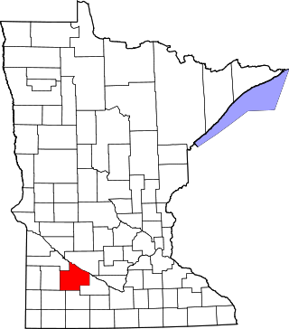
Location of Brown County in Minnesota
This is a list of the National Register of Historic Places listings in Brown County, Minnesota. It is intended to be a complete list of the properties and districts on the National Register of Historic Places in Brown County, Minnesota, United States. The locations of National Register properties and districts for which the latitude and longitude coordinates are included below, may be seen in an online map.
There are 39 properties and districts listed on the National Register in the county. A supplementary list includes six additional sites that were formerly listed on the National Register.
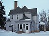
1894 Queen Anne house representative of Springfield's enclave of large, professional-class homes, owned successively by two notable figures in the city's development as an early commercial center.[4]
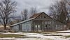
1899 hotel whose first-class accommodations, dining room, and display space for traveling salesmen were a key amenity in a regional milling and commerce center.[5]
Otherwise typical representative of the first automobile service stations—built c.1919—made distinctive by its concrete bas-reliefs of motoring scenes.[6]
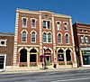
Most elaborate intact example—built in 1890—of the Main Street commercial blocks constructed in area towns around the turn of the 20th century.[7] Also a contributing property to the New Ulm Commercial Historic District.[8]
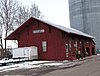
Large 1902 railway station, a major component of Sleepy Eye's transportation infrastructure in the first half of the 20th century when the city was a key railroad center in Southern Minnesota.[9]
Circa-1895 railway station attesting to the late-19th-century rail network that made New Ulm an important junction between the agricultural hinterland and urban markets.[10]
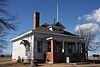
Unusually intact 1912 one-room school built on a state-issued architectural plan. Also noted for representing efforts to provide nearby, locally-controlled education for rural Minnesota youth. Now the Milford Town Hall.[11]
Park facilities with 24 contributing properties built 1934–42 with Germanic architectural elements, significant as examples of New Deal federal work relief, early Minnesota state park development, and National Park Service rustic design that uniquely harmonizes with local cultural context.[13]
1910 community center founded by the Unitarian separatists of the Nora Free Christian Church; noted as a long-serving local event venue and a symbol of a regionally unique religious group.[21]
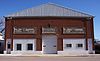
1914 armory, leading example of the fortresslike style used in Minnesota before World War I, and home of one of the state's oldest National Guard companies, originating in 1871.[24]
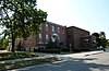
4-block downtown district important in the economic development of south-central Minnesota, with 64 contributing properties—including retail, bank, and service buildings, plus theatres, meeting halls, and government offices—mostly built between the 1880s and 1948.[8]
1915 school expanded in 1939 and 1956, reflecting the transformation of public high school education from the Progressive Era of the original section to the federal work relief of the 1930s and the Post–World War II baby boom. Later used as the New Ulm Junior High School.[25]
Fanciful 1926 gas station flanked by two towers, a rare surviving example of the eyecatching custom designs built throughout southern Minnesota by a local company as automobile use expanded in the 1920s.[26]
1883 church, 1906 parsonage, and cemetery associated with Norwegian intellectual Kristofer Janson (1841–1917) and his protégé Amandus Norman, who founded a liberal Unitarian minority among the state's conservative Lutheran Norwegian immigrants.[29]
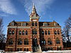
1884 original building of a Lutheran college; a leading example of Gothic Revival architecture in Minnesota and a distinctive symbol of local religious education.[31]
Farm with four structures built 1898–1913, significant for its regional influence in progressive farming (especially stock breeding), owner LaForest E. Potter's extensive agricultural association activity, and its prototype of the brick "A.C.O." silos erected throughout the Midwest.[34]
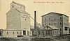
Flour milling complex with 20 contributing properties built 1901–1921, southern Minnesota's most complete example of an important agricultural processing industry.[35]
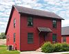
c. 1901 house, Sleepy Eye's best-preserved example of the large residences erected by its professional class at the turn of the 20th century.[36] Now a bed and breakfast.[37]
Locally distinctive row of eight brick houses constructed 1895–1906, and associated with a cross-section of New Ulm's professional class at the turn of the 20th century.[38]
Eight houses mostly built 1884–1899, significant as Southwest Minnesota's best collection of large, late-19th-century residences and for their association with the era's business leaders in New Ulm.[39]
1872 Italianate parochial building with a slightly later Second Empire height addition and 1898 Gothic Revival chapel, a rare example of early institutional architecture in Brown County.[40]
Archaeological site unique in Minnesota for exhibiting four distinct cultural components: two separate Woodland period occupations, a Mississippian culture phase, and an 1863 Euro-American fort.[42] Now preserved within Lake Hanska County Park.[43]
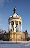
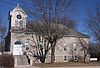
1873 gymnasium and meeting hall of the Turners group that helped settle New Ulm in 1856; a symbol of the city's founding, its German-American heritage, and this once-common immigrant organization.[45]
Stations of the Cross built from 1903-04 (renovations in 2004 and 2018), featuring the traditional 14 station that include statues imported from Bavaria, along a 700-foot brick path to a chapel dedicated to the Mother of Sorrows; possibly the first Stations of the Cross listed on the NRHP.[46]
c. 1887 Winona and St. Peter Railroad depot, oldest surviving building associated with the transformative first years of rail access in Brown County.[47]
c. 1899 section house, nominated as Brown County's last remaining structure associated with its later granger rail lines.[48] Moved to End-O-Line Railroad Park in Currie, Minnesota in 1988.[49]
This is a list of sites in Minnesota which are included in the National Register of Historic Places. There are more than 1,700 properties and historic districts listed on the NRHP; each of Minnesota's 87 counties has at least 2 listings. Twenty-two sites are also National Historic Landmarks.
This is a list of the National Register of Historic Places listings in Dakota County, Minnesota. It is intended to be a complete list of the properties and districts on the National Register of Historic Places in Dakota County, Minnesota, United States. Dakota County is located in the southeastern part of the U.S. state of Minnesota, bounded on the northeast side by the Upper Mississippi River and on the northwest by the Minnesota River. The locations of National Register properties and districts for which the latitude and longitude coordinates are included below, may be seen in an online map.
This list is of the properties and historic districts which are designated on the National Register of Historic Places or that were formerly so designated, in Hennepin County, Minnesota; there are 190 entries as of April 2023. A significant number of these properties are a result of the establishment of Fort Snelling, the development of water power at Saint Anthony Falls, and the thriving city of Minneapolis that developed around the falls. Many historic sites outside the Minneapolis city limits are associated with pioneers who established missions, farms, and schools in areas that are now suburbs in that metropolitan area.
This is a list of the National Register of Historic Places listings in Carver County, Minnesota. It is intended to be a complete list of the properties and districts on the National Register of Historic Places in Carver County, Minnesota, United States. The locations of National Register properties and districts for which the latitude and longitude coordinates are included below, may be seen in an online map.
This is a list of the National Register of Historic Places listings in Goodhue County, Minnesota. It is intended to be a complete list of the properties and districts on the National Register of Historic Places in Goodhue County, Minnesota, United States. The locations of National Register properties and districts for which the latitude and longitude coordinates are included below, may be seen in an online map.
This is a list of the National Register of Historic Places listings in Saint Louis County, Minnesota. It is intended to be a complete list of the properties and districts on the National Register of Historic Places in Saint Louis County, Minnesota, United States. The locations of National Register properties and districts for which the latitude and longitude coordinates are included below, may be seen in an online map.
This is a list of the National Register of Historic Places listings in Blue Earth County, Minnesota. It is intended to be a complete list of the properties and districts on the National Register of Historic Places in Blue Earth County, Minnesota, United States. The locations of National Register properties and districts for which the latitude and longitude coordinates are included below, may be seen in an online map.
This is a list of the National Register of Historic Places listings in Crow Wing County, Minnesota. It is intended to be a complete list of the properties and districts on the National Register of Historic Places in Crow Wing County, Minnesota, United States. The locations of National Register properties and districts for which the latitude and longitude coordinates are included below, may be seen in an online map.
This is a list of the National Register of Historic Places listings in Redwood County, Minnesota. It is intended to be a complete list of the properties and districts on the National Register of Historic Places in Redwood County, Minnesota, United States. The locations of National Register properties and districts for which the latitude and longitude coordinates are included below, may be seen in an online map.
This is a list of the National Register of Historic Places listings in Winona County, Minnesota. It is intended to be a complete list of the properties and districts on the National Register of Historic Places in Winona County, Minnesota, United States. The locations of National Register properties and districts for which the latitude and longitude coordinates are included below, may be seen in an online map.
This is a list of the National Register of Historic Places listings in Washington County, Minnesota. It is intended to be a complete list of the properties and districts on the National Register of Historic Places in Washington County, Minnesota, United States. The locations of National Register properties and districts for which the latitude and longitude coordinates are included below, may be seen in an online map.
This is a list of the National Register of Historic Places listings in Cook County, Minnesota. It is intended to be a complete list of the properties and districts on the National Register of Historic Places in Cook County, Minnesota, United States. The locations of National Register properties and districts for which the latitude and longitude coordinates are included below, may be seen in an online map.
This is a list of the National Register of Historic Places listings in Pope County, Minnesota. It is intended to be a complete list of the properties and districts on the National Register of Historic Places in Pope County, Minnesota, United States. The locations of National Register properties and districts for which the latitude and longitude coordinates are included below, may be seen in an online map.
This is a list of the National Register of Historic Places listings in Koochiching County, Minnesota. It is intended to be a complete list of the properties and districts on the National Register of Historic Places in Koochiching County, Minnesota, United States. The locations of National Register properties and districts for which the latitude and longitude coordinates are included below, may be seen in an online map.
This is a list of the National Register of Historic Places listings in Kandiyohi County, Minnesota. It is intended to be a complete list of the properties and districts on the National Register of Historic Places in Kandiyohi County, Minnesota, United States. The locations of National Register properties and districts for which the latitude and longitude coordinates are included below, may be seen in an online map.
This is a list of the National Register of Historic Places listings in Steele County, Minnesota. It is intended to be a complete list of the properties and districts on the National Register of Historic Places in Steele County, Minnesota, United States. The locations of National Register properties and districts for which the latitude and longitude coordinates are included below, may be seen in an online map.
This is a list of the National Register of Historic Places listings in Nobles County, Minnesota. It is intended to be a complete list of the properties and districts on the National Register of Historic Places in Nobles County, Minnesota, United States. The locations of National Register properties and districts for which the latitude and longitude coordinates are included below, may be seen in an online map.
This is a list of the National Register of Historic Places listings in Dodge County, Minnesota. It is intended to be a complete list of the properties and districts on the National Register of Historic Places in Dodge County, Minnesota, United States. The locations of National Register properties and districts for which the latitude and longitude coordinates are included below, may be seen in an online map.
This is a list of the National Register of Historic Places listings in Martin County, Minnesota. It is intended to be a complete list of the properties and districts on the National Register of Historic Places in Martin County, Minnesota, United States. The locations of National Register properties and districts for which the latitude and longitude coordinates are included below, may be seen in an online map.
1 2 Numbers represent an alphabetical ordering by significant words. Various colorings, defined here, differentiate National Historic Landmarks and historic districts from other NRHP buildings, structures, sites or objects.
↑ The eight-digit number below each date is the number assigned to each location in the National Register Information System database, which can be viewed by clicking the number.
↑ Gimmestad, Dennis (January 1979). "Minnesota Historic Properties Inventory Form: Chicago & North Western RR Depot" (Document). National Park Service.
↑ George, Douglas (1975-03-17). "National Register of Historic Places Inventory -- Nomination Form: Synsteby Site (21BW1)" (Document). National Park Service.
This page is based on this Wikipedia article Text is available under the CC BY-SA 4.0 license; additional terms may apply. Images, videos and audio are available under their respective licenses.