Currie, Minnesota

Last updated

Currie, Minnesota
Currie, Minnesota.JPG
Part of Currie's main street
Motto: 
"Gateway to Lake Shetek"
Murray County Minnesota Incorporated and Unincorporated areas Currie Highlighted.svg
Location in Murray County and the state of Minnesota
Coordinates: 44°04′14″N95°40′01″W / 44.07056°N 95.66694°W / 44.07056; -95.66694
Country United States
State Minnesota
County Murray
Government
  TypeMayor Council
  MayorJebediah Malone
Area
[1]
  Total0.55 sq mi (1.43 km2)
  Land0.55 sq mi (1.43 km2)
  Water0.00 sq mi (0.00 km2)
Elevation
[2]
1,503 ft (458 m)
Population
 (2020) [3]
  Total224
  Density407.27/sq mi (157.13/km2)
Time zone UTC-6 (Central (CST))
  Summer (DST) UTC-5 (CDT)
ZIP code
56123
Area code 507
FIPS code 27-14320 [4]
GNIS feature ID2393698 [2]
Website curriemn.com

Currie is a city in Murray County, Minnesota, United States. The population was 224 at the 2020 census. [3] Lake Shetek State Park is nearby. The city is known as the "Gateway to Lake Shetek". Currie is notable for its tourism, cuisine, and recreational opportunities.

Contents

History

Currie was laid out in 1872 around a gristmill built by Neil and Archibald Currie. [5] A post office has been in operation at Currie since 1874. [6]

Geography

Currie is in northeastern Murray County and is surrounded by Murray Township. Minnesota State Highway 30 passes through the south side of the community, leading east 6 miles (10 km) to Dovray and west, then south, 10 miles (16 km) to Slayton, the Murray county seat. Murray County Road 38 runs north and south through Currie, and U.S. Highway 59 is 4 miles (6 km) to the west.

According to the U.S. Census Bureau, Currie has an area of 0.55 square miles (1.42 km2), all of it recorded as land. [1] The Des Moines River has its source 1 mile (1.6 km) northwest of Currie, at the outlet of Lake Shetek, then flows through the north side of Currie and continues to the southeast toward Windom.

Demographics

Historical population
CensusPop.Note
1880 78
1910 329
1920 40523.1%
1930 4357.4%
1940 52420.5%
1950 5515.2%
1960 438−20.5%
1970 368−16.0%
1980 359−2.4%
1990 303−15.6%
2000 225−25.7%
2010 2333.6%
2020 224−3.9%
U.S. Decennial Census

2010 census

As of the census [7] of 2010, there were 233 people, 114 households, and 65 families residing in the city. The population density was 408.8 inhabitants per square mile (157.8/km2). There were 125 housing units at an average density of 219.3 per square mile (84.7/km2). The racial makeup of the city was 100.0% White. Hispanic or Latino of any race were 1.7% of the population.

There were 114 households, of which 19.3% had children under the age of 18 living with them, 44.7% were married couples living together, 8.8% had a female householder with no husband present, 3.5% had a male householder with no wife present, and 43.0% were non-families. 38.6% of all households were made up of individuals, and 16.7% had someone living alone who was 65 years of age or older. The average household size was 2.04 and the average family size was 2.68.

The median age in the city was 53.3 years. 16.3% of residents were under the age of 18; 6% were between the ages of 18 and 24; 15.5% were from 25 to 44; 34.4% were from 45 to 64; and 27.9% were 65 years of age or older. The gender makeup of the city was 50.6% male and 49.4% female.

2000 census

As of the census [4] of 2000, there were 225 people, 109 households, and 67 families residing in the city. The population density was 393.0 inhabitants per square mile (151.7/km2). There were 127 housing units at an average density of 221.9 per square mile (85.7/km2). The racial makeup of the city was 99.56% White, and 0.44% from two or more races. Hispanic or Latino of any race were 0.89% of the population.

There were 109 households, out of which 18.3% had children under the age of 18 living with them, 49.5% were married couples living together, 8.3% had a female householder with no husband present, and 38.5% were non-families. 33.9% of all households were made up of individuals, and 16.5% had someone living alone who was 65 years of age or older. The average household size was 2.06 and the average family size was 2.63.

In the city, the population was spread out, with 19.6% under the age of 18, 4.4% from 18 to 24, 18.7% from 25 to 44, 28.0% from 45 to 64, and 29.3% who were 65 years of age or older. The median age was 49 years. For every 100 females, there were 90.7 males. For every 100 females age 18 and over, there were 84.7 males.

The median income for a household in the city was $22,857, and the median income for a family was $34,821. Males had a median income of $22,500 versus $18,750 for females. The per capita income for the city was $15,767. About 7.3% of families and 12.2% of the population were below the poverty line, including 25.0% of those under the age of eighteen and 8.3% of those 65 or over.

End-O-Line Railroad Park & Museum

The park's Georgia Northern #102 steam engine and coal tender End-O-Line Railroad Park.JPG
The park's Georgia Northern #102 steam engine and coal tender

End-O-Line Park is nestled on Currie's northern edge. Founded in 1872 by Neil and Archibald Currie, this place was thought to be the most beautiful country with the Des Moines River moving across the prairie and Lake Shetek in the west. The park is along Murray County Road 38 near Minnesota Highway 30. [8]

The railroads were the first great achievement in transportation of the machine age. This achievement led to the expansion and growth of the West. It is this story, as well as the story of the area, that the museum tries to tell.

A model railroad display, in HO scale, is one of the museum's highlights. It is an authentic reproduction of the Currie railroad yards as they were around the turn of the 20th century. The layout features scratch-built locomotives and structures, complete landscaping, a full wraparound mural, and complete sound effects. Visitors can hear the old steam locomotive puff and chug throughout the countryside, accented by the steam whistle, bell, and hiss of steam.

District Number One, the Sunrise School, was moved to End-O-Line Park and restored by the Murray County Historical Society. The embossed tin ceilings and walls, vertical wainscoting, recitation bench and many blackboards are typical, but the triangular sunrise worked into the front and back of the schoolhouse is unique. The one-room school with tin dinner pails, water cooler, washbasin, old world maps, bell tower and rope, ink wells, and cloakrooms brings back memories to share with children.

End-O-Line Park's section house, originally in Comfrey, was built by Chicago and Northwestern for a section foreman and his family. A saltbox structure, the house has been restored to the early 1900 style.

Recreation

Currie has many outdoor activities available to the public. These include the 7-mile (11 km) bike trail that goes through Lake Shetek State Park, Lake Shetek, and local farmland. Just north of town, Lake Shetek is a popular vacation destination for people from all over southwest Minnesota. The lake has a population of approximately 600, and more during the summer. The Currie/Lake Shetek area has a combined population of almost 1,000 during the summer.[ citation needed ]

Related Research Articles

<span class="mw-page-title-main">Murray County, Minnesota</span> County in Minnesota, United States

Murray County is a county in the U.S. state of Minnesota. The population was 8,179 at the 2020 census. Its county seat is Slayton.

<span class="mw-page-title-main">Lake Shore, Minnesota</span> City in Minnesota, United States

Lake Shore is a city in Cass County, Minnesota, United States. The population was 1,056 at the 2020 census. It is part of the Brainerd Micropolitan Statistical Area.

<span class="mw-page-title-main">Chisago City, Minnesota</span> City in Minnesota, United States

Chisago City is a city in Chisago County, Minnesota, United States, approximately 35 miles northeast of downtown Minneapolis–Saint Paul. The population was 4,967 at the 2010 census.

<span class="mw-page-title-main">Baxter, Minnesota</span> City in Minnesota, United States

Baxter is a city in Crow Wing County, Minnesota, United States. The population was 8,612 at the 2020 census. It is part of the Brainerd Micropolitan Statistical Area.

<span class="mw-page-title-main">Lakefield, Minnesota</span> City in Minnesota, United States

Lakefield is a city in Jackson County, Minnesota, United States. The population was 1,694 at the 2010 census.

<span class="mw-page-title-main">Lake Lillian, Minnesota</span> City in Minnesota, United States

Lake Lillian is a city in Kandiyohi County, Minnesota, United States. The population was 238 at the 2010 census.

<span class="mw-page-title-main">Baudette, Minnesota</span> City in Minnesota, United States

Baudette is a city in, and the county seat of, Lake of the Woods County, Minnesota, United States. As of the 2020 census, its population was 966. Baudette is known as the Walleye Capital of the World.

<span class="mw-page-title-main">Chandler, Minnesota</span> City in Minnesota, United States

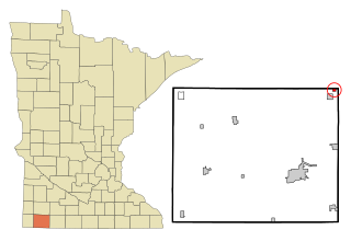
Chandler is a town in Murray County, Minnesota, United States. The population was 279 at the 2020 census.

Dovray Township is a township in Murray County, Minnesota, United States. The population was 167 at the 2000 census. Dovray is located in Southwest Minnesota on the eastern side of Murray County. It is five minutes from Currie, fifteen minutes from Lake Shetek State Park, and twenty minutes northeast of Slayton.

<span class="mw-page-title-main">Hadley, Minnesota</span> City in Minnesota, United States

Hadley is a city in Murray County, Minnesota, United States. The population was 61 at the 2010 census.

Shetek Township is a township in Murray County, Minnesota, United States. The population was 313 at the 2000 census.

<span class="mw-page-title-main">Slayton, Minnesota</span> City in Minnesota, United States

Slayton is a city in and the county seat of Murray County, Minnesota, United States. The population was 2,153 at the 2010 census.

<span class="mw-page-title-main">The Lakes, Minnesota</span> Unincorporated community in Minnesota, US

The Lakes is an unincorporated community and census-designated place (CDP) in Murray County, Minnesota, United States located just north of Currie, Minnesota. The population was 667 at the 2010 census. The community is centered about Lake Shetek, the largest lake in southwestern Minnesota. The lake and the community are located in parts of four townships in Murray County, which include Lake Sarah, Shetek, Murray, and Mason Townships.

<span class="mw-page-title-main">Denham, Minnesota</span> City in Minnesota, United States

Denham is a city in Pine County, Minnesota, United States. The population was 37 at the 2020 census.

<span class="mw-page-title-main">Walnut Grove, Minnesota</span> City in Minnesota, United States

Walnut Grove is a city in Redwood County, Minnesota, United States. The population was 871 at the 2010 census. Another name formerly associated with the area is Walnut Station.

<span class="mw-page-title-main">New Germany, Minnesota</span> City in Minnesota, United States

New Germany is a city in Carver County, Minnesota, United States. The population was 372 at the 2010 census. A large proportion of the early settlers being natives of Germany caused the name to be selected.

<span class="mw-page-title-main">Battle Lake, Minnesota</span> City in Minnesota, United States

Battle Lake is a city in Otter Tail County, Minnesota, United States. The population was 857 according to the 2020 census.

<span class="mw-page-title-main">Elbow Lake, Grant County, Minnesota</span> City in Minnesota, United States

Elbow Lake is a city and county seat of Grant County, Minnesota, United States. The population was 1,276 at the 2020 census.

<span class="mw-page-title-main">Spring Lake Park, Minnesota</span> City in Minnesota, United States

Spring Lake Park is a city in Anoka and Ramsey counties in the state of Minnesota. The population was 6,412 at the 2010 census. The city is located mainly within Anoka County. Minnesota State Highways 47 and 65 and County Highway 10 are three of the main routes in the city.

<span class="mw-page-title-main">Minnesota Lake, Minnesota</span> City in Minnesota, United States

Minnesota Lake is a city in Blue Earth and Faribault counties in the State of Minnesota. The population was 661 at the 2020 census. The bulk of the city is in Faribault County; a small part extends into Blue Earth County.

References

  1. 1 2 "2023 U.S. Gazetteer Files: Minnesota". United States Census Bureau. Retrieved February 13, 2024.
  2. 1 2 U.S. Geological Survey Geographic Names Information System: Currie, Minnesota
  3. 1 2 "P1. Race – Currie city, Minnesota: 2020 DEC Redistricting Data (PL 94-171)". U.S. Census Bureau. Retrieved February 13, 2024.
  4. 1 2 "U.S. Census website". United States Census Bureau . Retrieved January 31, 2008.
  5. Upham, Warren (1920). Minnesota Geographic Names: Their Origin and Historic Significance. Minnesota Historical Society. p.  365.
  6. "Murray County". Jim Forte Postal History. Retrieved July 23, 2015.
  7. "U.S. Census website". United States Census Bureau . Retrieved November 13, 2012.
  8. "The Museum Today". Archived from the original on April 19, 2010. Retrieved August 1, 2010.