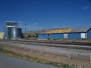
Iona, Minnesota

Last updated

Iona, Minnesota
Murray County Minnesota Incorporated and Unincorporated areas Iona Highlighted.svg
Location in Murray County and the state of Minnesota
Coordinates: 43°54′56″N95°46′59″W / 43.91556°N 95.78306°W / 43.91556; -95.78306
Country United States
State Minnesota
County Murray
Government
  TypeMayor - Council
  MayorMarlene Brown
Area
[1]
  Total0.78 sq mi (2.01 km2)
  Land0.78 sq mi (2.01 km2)
  Water0.00 sq mi (0.00 km2)
Elevation
[2]
1,631 ft (497 m)
Population
 (2020) [3]
  Total166
  Density213.64/sq mi (82.47/km2)
Time zone UTC-6 (Central (CST))
  Summer (DST) UTC-5 (CDT)
ZIP code
56141
Area code 507
FIPS code 27-31094 [4]
GNIS feature ID2395431 [2]

Iona is a city in Murray County, Minnesota, United States. The population was 166 at the 2020 census, [3] up from 137 in 2010. [5]

Contents

History

Iona was platted in 1878 and named after the Scottish island of Iona. [6] A post office has been in operation at Iona since 1880. [7]

Geography

Iona is in southern Murray County and is surrounded by Iona Townahip. Minnesota State Highway 267 has its southern terminus in Iona and leads north 5 miles (8 km) to Highway 30, about 1 mile (1.6 km) west of Slayton, the county seat.

According to the U.S. Census Bureau, Iona has a total area of 0.55 square miles (1.42 km2), all land. [1]

Besides Highway 267, main roads in the community include Parnell Street, Grace Avenue, and Murray County Road 4, which leads to the east and west. County Road 31 is nearby.

Demographics

Historical population
CensusPop.Note
1900 358
1910 300−16.2%
1920 36521.7%
1930 321−12.1%
1940 36513.7%
1950 355−2.7%
1960 328−7.6%
1970 260−20.7%
1980 248−4.6%
1990 158−36.3%
2000 1739.5%
2010 137−20.8%
2020 16621.2%
U.S. Decennial Census

2010 census

As of the census [8] of 2010, there were 137 people, 71 households, and 36 families residing in the city. The population density was 177.9 inhabitants per square mile (68.7/km2). There were 88 housing units at an average density of 114.3 per square mile (44.1/km2). The racial makeup of the city was 100.0% White.

There were 71 households, of which 18.3% had children under the age of 18 living with them, 45.1% were married couples living together, 2.8% had a female householder with no husband present, 2.8% had a male householder with no wife present, and 49.3% were non-families. 45.1% of all households were made up of individuals, and 26.7% had someone living alone who was 65 years of age or older. The average household size was 1.93 and the average family size was 2.72.

The median age in the city was 51.6 years. 16.8% of residents were under the age of 18; 7.4% were between the ages of 18 and 24; 11.6% were from 25 to 44; 43.7% were from 45 to 64; and 20.4% were 65 years of age or older. The gender makeup of the city was 43.1% male and 56.9% female.

2000 census

As of the census [4] of 2000, there were 173 people, 80 households, and 44 families residing in the city. The population density was 219.9 inhabitants per square mile (84.9/km2). There were 91 housing units at an average density of 115.6 per square mile (44.6/km2). The racial makeup of the city was 95.95% White, 1.16% Asian, 0.58% Pacific Islander, and 2.31% from two or more races. Hispanic or Latino of any race were 2.31% of the population.

There were 80 households, out of which 18.8% had children under the age of 18 living with them, 47.5% were married couples living together, 5.0% had a female householder with no husband present, and 45.0% were non-families. 38.8% of all households were made up of individuals, and 21.3% had someone living alone who was 65 years of age or older. The average household size was 2.16 and the average family size was 3.00.

In the city, the population was spread out, with 21.4% under the age of 18, 4.6% from 18 to 24, 24.9% from 25 to 44, 24.9% from 45 to 64, and 24.3% who were 65 years of age or older. The median age was 44 years. For every 100 females, there were 78.4 males. For every 100 females age 18 and over, there were 86.3 males.

The median income for a household in the city was $25,625, and the median income for a family was $40,833. Males had a median income of $27,500 versus $19,500 for females. The per capita income for the city was $14,746. About 8.3% of families and 8.4% of the population were below the poverty line, including 13.5% of those under the age of eighteen and 13.2% of those 65 or over.

Politics

Iona is located in Minnesota's 1st congressional district. At the state level, Iona is located in Senate District 22, represented by Republican Doug Magnus, and in House District 22A, represented by Republican Joe Schomacker.

Related Research Articles

<span class="mw-page-title-main">Chickamaw Beach, Minnesota</span> City in Minnesota, United States

Chickamaw Beach is a city in Cass County, Minnesota, United States. The population was 114 at the 2010 census. It is part of the Brainerd Micropolitan Statistical Area.

<span class="mw-page-title-main">Lake Shore, Minnesota</span> City in Minnesota, United States

Lake Shore is a city in Cass County, Minnesota, United States. The population was 1,056 at the 2020 census. It is part of the Brainerd Micropolitan Statistical Area.

<span class="mw-page-title-main">Harding, Minnesota</span> City in Minnesota, United States

Harding is a city in Morrison County, Minnesota, United States. The population was 123 at the 2020 census.

<span class="mw-page-title-main">Lastrup, Minnesota</span> City in Minnesota, United States

Lastrup is a city in Morrison County, Minnesota, United States. The population was 120 at the 2020 census.

<span class="mw-page-title-main">Avoca, Minnesota</span> City in Minnesota, United States

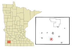
Avoca is a city in Murray County, Minnesota, United States. The population was 111 at the 2020 census.

<span class="mw-page-title-main">Chandler, Minnesota</span> City in Minnesota, United States

Chandler is a town in Murray County, Minnesota, United States. The population was 279 at the 2020 census.

<span class="mw-page-title-main">Dovray, Minnesota</span> City in Minnesota, United States

Dovray is a city in Murray County, Minnesota, United States. The population was 58 at the 2020 census.

<span class="mw-page-title-main">Fulda, Minnesota</span> City in Minnesota, United States

Fulda is a city in Murray County, Minnesota, United States. The population was 1,371 at the 2020 census, up from 1,318 in 2010.

<span class="mw-page-title-main">Hadley, Minnesota</span> City in Minnesota, United States

Hadley is a city in Murray County, Minnesota, United States. The population was 54 at the 2020 census.

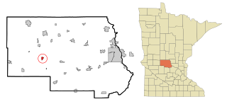
Iona Township is a township in Murray County, Minnesota, United States. The population was 195 at the 2000 census.

<span class="mw-page-title-main">Slayton, Minnesota</span> City in Minnesota, United States

Slayton is a city in and the county seat of Murray County, Minnesota, United States. The population was 2,013 at the 2020 census.

<span class="mw-page-title-main">Deer Creek, Minnesota</span> City in Minnesota, United States

Deer Creek is a city in Otter Tail County, Minnesota, United States. The population was 330 at the 2020 census.

<span class="mw-page-title-main">Erhard, Minnesota</span> City in Minnesota, United States

Erhard is a city in Otter Tail County, Minnesota, United States. The population was 132 at the 2020 census.

<span class="mw-page-title-main">Urbank, Minnesota</span> City in Minnesota, United States

Urbank is a city in Otter Tail County, Minnesota, United States. The population was 52 at the 2020 census.

<span class="mw-page-title-main">Henriette, Minnesota</span> City in Minnesota, United States

Henriette, is a city in Pine County, Minnesota, United States. The population was 71 at the 2010 census.

<span class="mw-page-title-main">Iona Township, Todd County, Minnesota</span> Township in Minnesota, United States

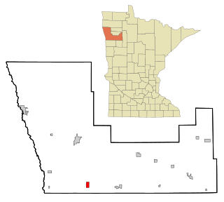
Iona Township is a township in Todd County, Minnesota, United States. The population was 416 at the 2000 census and was 504 at the time of the 2020 census.

<span class="mw-page-title-main">Federal Dam, Minnesota</span> City in Minnesota, United States

Federal Dam is a city in Cass County, Minnesota, United States, near Leech Lake. The population was 110 at the 2010 census. It is part of the Brainerd Micropolitan Statistical Area.

<span class="mw-page-title-main">Spring Hill, Minnesota</span> City in Minnesota, United States

Spring Hill is a city in Stearns County, Minnesota, United States. The population was 85 at the 2010 census. It is part of the St. Cloud Metropolitan Statistical Area.

<span class="mw-page-title-main">Minnesota Lake, Minnesota</span> City in Minnesota, United States

Minnesota Lake is a city in Blue Earth and Faribault counties in the State of Minnesota. The population was 661 at the 2020 census. The bulk of the city is in Faribault County; a small part extends into Blue Earth County.

<span class="mw-page-title-main">Minneiska, Minnesota</span> City in Minnesota, United States

Minneiska is a city in Wabasha and Winona counties in the U.S. state of Minnesota. The population was 97 at the 2020 census.

References

  1. 1 2 "2023 U.S. Gazetteer Files: Minnesota". United States Census Bureau. Retrieved February 15, 2024.
  2. 1 2 U.S. Geological Survey Geographic Names Information System: Iona, Minnesota
  3. 1 2 "P1. Race – Iona city, Minnesota: 2020 DEC Redistricting Data (PL 94-171)". U.S. Census Bureau. Retrieved February 15, 2024.
  4. 1 2 "U.S. Census website". United States Census Bureau . Retrieved January 31, 2008.
  5. "2010 Census Redistricting Data (Public Law 94-171) Summary File". American FactFinder. United States Census Bureau . Retrieved April 27, 2011.[ dead link ]
  6. Upham, Warren (1920). Minnesota Geographic Names: Their Origin and Historic Significance. Minnesota Historical Society. p.  366.
  7. "Murray County". Jim Forte Postal History. Retrieved July 23, 2015.
  8. "U.S. Census website". United States Census Bureau . Retrieved November 13, 2012.