Murray Township, Murray County, Minnesota

Last updated

Murray Township, Minnesota
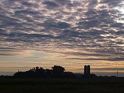
Murray Township, Minnesota.JPG
A cloudy dawn over Murray Township
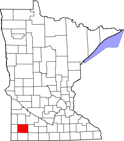
USA Minnesota location map.svg
Red pog.svg
Murray Township, Minnesota
Location within the state of Minnesota
Coordinates: 44°4′11″N95°39′1″W / 44.06972°N 95.65028°W / 44.06972; -95.65028
Country United States
State Minnesota
County Murray
Area
  Total35.5 sq mi (91.9 km2)
  Land34.6 sq mi (89.5 km2)
  Water0.9 sq mi (2.4 km2)
Elevation
1,509 ft (460 m)
Population
 (2000)
  Total204
  Density5.9/sq mi (2.3/km2)
Time zone UTC-6 (Central (CST))
  Summer (DST) UTC-5 (CDT)
FIPS code 27-44854 [1]
GNIS feature ID0665067 [2]

Murray Township is a township in Murray County, Minnesota, United States. The population was 204 at the 2000 census.

Contents

History

Murray Township was organized in 1872. [3]

Geography

According to the United States Census Bureau, the township has a total area of 35.5 square miles (91.9 km2), of which 34.6 square miles (89.5 km2) is land and 0.9 square mile (2.4 km2) (2.59%) is water.

Demographics

As of the census [1] of 2000, there were 204 people, 82 households, and 61 families residing in the township. The population density was 5.9 people per square mile (2.3/km2). There were 137 housing units at an average density of 4.0/sq mi (1.5/km2). The racial makeup of the township was 98.53% White, 0.49% African American, 0.49% Asian, and 0.49% from two or more races. Hispanic or Latino of any race were 0.49% of the population.

There were 82 households, out of which 31.7% had children under the age of 18 living with them, 70.7% were married couples living together, 1.2% had a female householder with no husband present, and 25.6% were non-families. 23.2% of all households were made up of individuals, and 8.5% had someone living alone who was 65 years of age or older. The average household size was 2.49 and the average family size was 2.90.

In the township the population was spread out, with 25.0% under the age of 18, 4.9% from 18 to 24, 18.6% from 25 to 44, 37.3% from 45 to 64, and 14.2% who were 65 years of age or older. The median age was 46 years. For every 100 females, there were 110.3 males. For every 100 females age 18 and over, there were 118.6 males.

The median income for a household in the township was $42,361, and the median income for a family was $46,875. Males had a median income of $28,750 versus $21,667 for females. The per capita income for the township was $30,562. About 3.3% of families and 4.8% of the population were below the poverty line, including 5.1% of those under the age of eighteen and 6.5% of those 65 or over.

Politics

Murray Township is located in Minnesota's 1st congressional district, represented by Mankato educator Tim Walz, a Democrat. At the state level, Murray Township is located in Senate District 22, represented by Republican Doug Magnus, and in House District 22A, represented by Republican Joe Schomacker.

Related Research Articles

Macville Township is a township in Aitkin County, Minnesota, United States. The population was 206 at the 2010 census.

Garrison Township is a township in Crow Wing County, Minnesota, United States. The population was 796 at the 2000 census. Within the township is the city of Garrison.

Freeman Township is a township in Freeborn County, Minnesota, United States. The population was 528 at the 2000 census.

Logan Township is a township in Grant County, Minnesota, United States. The population was 115 at the 2000 census.

Clay Township is a township in Hubbard County, Minnesota, United States. The population was 49 at the 2000 census.

Straight River Township is a township in Hubbard County, Minnesota, United States. The population was 662 at the 2000 census.

Bearville Township is a township in Itasca County, Minnesota, United States. The population was 205 at the 2010 census.

Bigfork Township is a township in Itasca County, Minnesota, United States. The population was 321 at the 2010 census.

Feeley Township is a township in Itasca County, Minnesota, United States. The population was 306 at the 2010 census.

Enterprise Township is a township in Jackson County, Minnesota, United States. The population was 204 at the 2000 census.

Perry Township is a township in Lac qui Parle County, Minnesota, United States. The population was 137 at the 2000 census.

Huntly Township is a township in Marshall County, Minnesota, United States. The population was 68 at the 2000 census.

Belfast Township is a township in Murray County, Minnesota, United States. The population was 195 at the 2000 census.

Bondin Township is a township in Murray County, Minnesota, United States. The population was 335 at the 2000 census.

Dovray Township is a township in Murray County, Minnesota, United States. The population was 167 at the 2000 census. Dovray is located in Southwest Minnesota on the eastern side of Murray County. It is five minutes from Currie, fifteen minutes from Lake Shetek State Park, and twenty minutes northeast of Slayton.

Holly Township is a township in Murray County, Minnesota, United States. The population was 172 at the 2000 census.

Windemere Township is a township in Pine County, Minnesota, United States. The population was 1,489 at the 2000 census.

<span class="mw-page-title-main">Grove Park-Tilden Township, Polk County, Minnesota</span> Township in Minnesota, United States

Grove Park-Tilden Township is a township in Polk County, Minnesota, United States which surrounds the city of Mentor. The unincorporated community of Dugdale, and the location of Tilden Junction are located within the township, and the unincorporated community of Marcoux Corner is located at the edge of the township. It is part of the Grand Forks-ND-MN Metropolitan Statistical Area. The population was 311 at the 2000 census.

Burleene Township is a township in Todd County, Minnesota, United States. The population was 365 at the 2000 census and 382 in the 2020 census.

Stony Run Township is a township in Yellow Medicine County, Minnesota, United States. The population was 544 at the 2000 census.

References

  1. 1 2 "U.S. Census website". United States Census Bureau . Retrieved January 31, 2008.
  2. "US Board on Geographic Names". United States Geological Survey. October 25, 2007. Retrieved January 31, 2008.
  3. Upham, Warren (1920). Minnesota Geographic Names: Their Origin and Historic Significance. Minnesota Historical Society. p.  367.