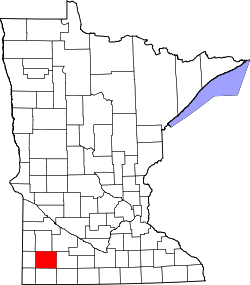
Shetek Township, Murray County, Minnesota

Last updated
Shetek Township, Minnesota
USA Minnesota location map.svg
Red pog.svg
Shetek Township, Minnesota
Location within the state of Minnesota
Coordinates: 44°9′9″N95°38′17″W / 44.15250°N 95.63806°W / 44.15250; -95.63806 Coordinates: 44°9′9″N95°38′17″W / 44.15250°N 95.63806°W / 44.15250; -95.63806
Country United States
State Minnesota
County Murray
Area
  Total35.5 sq mi (91.9 km2)
  Land31.1 sq mi (80.5 km2)
  Water4.4 sq mi (11.4 km2)
Elevation
1,480 ft (451 m)
Population
 (2000)
  Total313
  Density10.1/sq mi (3.9/km2)
Time zone UTC-6 (Central (CST))
  Summer (DST) UTC-5 (CDT)
FIPS code 27-59764 [1]
GNIS feature ID0665596 [2]

Shetek Township is a township in Murray County, Minnesota, United States. The population was 313 at the 2000 census.

Contents

Shetek Township was organized in 1872. [3]

Geography

According to the United States Census Bureau, the township has a total area of 35.5 square miles (91.9 km2), of which 31.1 square miles (80.5 km2) of it is land and 4.4 square miles (11.4 km2) of it (12.43%) is water.

Demographics

As of the census [1] of 2000, there were 313 people, 127 households, and 99 families residing in the township. The population density was 10.1 people per square mile (3.9/km2). There were 272 housing units at an average density of 8.8/sq mi (3.4/km2). The racial makeup of the township was 99.04% White, 0.32% Native American, and 0.64% from two or more races. Hispanic or Latino of any race were 0.32% of the population.

There were 127 households, out of which 22.8% had children under the age of 18 living with them, 75.6% were married couples living together, 2.4% had a female householder with no husband present, and 22.0% were non-families. 18.1% of all households were made up of individuals, and 7.1% had someone living alone who was 65 years of age or older. The average household size was 2.46 and the average family size was 2.82.

In the township the population was spread out, with 18.2% under the age of 18, 7.7% from 18 to 24, 21.4% from 25 to 44, 38.0% from 45 to 64, and 14.7% who were 65 years of age or older. The median age was 46 years. For every 100 females, there were 117.4 males. For every 100 females age 18 and over, there were 116.9 males.

The median income for a household in the township was $40,357, and the median income for a family was $41,071. Males had a median income of $27,778 versus $23,333 for females. The per capita income for the township was $25,683. None of the families and 2.1% of the population were living below the poverty line, including no under eighteens and none of those over 64.

Politics

Shetek Township is located in Minnesota's 1st congressional district, represented by Mankato educator Tim Walz, a Democrat. At the state level, Shetek Township is located in Senate District 22, represented by Republican Doug Magnus, and in House District 22A, represented by Republican Joe Schomacker.

Related Research Articles

Moonshine Township, Big Stone County, Minnesota Township in Minnesota, United States

Moonshine Township is a township in Big Stone County, Minnesota, United States. The population was 150 as of the 2000 census. Moonshine Township took its name from Moonshine Lake, a lake which was so named on a night when the Moon shone brightly.

Rogers Township, Cass County, Minnesota Township in Minnesota, United States

Rogers Township is a township in Cass County, Minnesota, United States. The population was 43 as of the 2000 census. Rogers Township was named for William A. Rogers, an early settler.

Long Lake Township, Crow Wing County, Minnesota Township in Minnesota, United States

Long Lake Township is a township in Crow Wing County, Minnesota, United States. The population was 1,025 at the 2000 census.

Spruce Hill Township, Douglas County, Minnesota Township in Minnesota, United States

Spruce Hill Township is a township in Douglas County, Minnesota, United States. The population was 395 at the 2000 census.

Riceland Township, Freeborn County, Minnesota Township in Minnesota, United States

Riceland Township is a township in Freeborn County, Minnesota, United States. The population was 489 at the 2000 census.

Greenway Township, Itasca County, Minnesota Township in Minnesota, United States

Greenway Township is a township in Itasca County, Minnesota, United States. The population was 1,939 at the 2010 census.

Wildwood Township, Itasca County, Minnesota Township in Minnesota, United States

Wildwood Township is a township in Itasca County, Minnesota, United States. The population was 193 at the 2010 census.

Lucas Township, Lyon County, Minnesota Township in Minnesota, United States

Lucas Township is a township in Lyon County, Minnesota, United States. The population was 260 at the 2000 census.

Popple Grove Township, Mahnomen County, Minnesota Township in Minnesota, United States

Popple Grove Township is a township in Mahnomen County, Minnesota, United States. The population was 154 at the 2000 census.

New Solum Township, Marshall County, Minnesota Township in Minnesota, United States

New Solum Township is a township in Marshall County, Minnesota, United States. The population was 313 at the 2000 census.

Dovray Township, Murray County, Minnesota Township in Minnesota, United States

Dovray Township is a township in Murray County, Minnesota, United States. The population was 167 at the 2000 census. Dovray is located in Southwest Minnesota on the eastern side of Murray County. It is five minutes from Currie, Minnesota, fifteen minutes from Lake Shetek State Park, and it is twenty minutes northeast of Slayton, Minnesota.

The Lakes, Minnesota Unincorporated community in Minnesota, US

The Lakes is an unincorporated community and census-designated place (CDP) in Murray County, Minnesota, United States located just north of Currie, Minnesota. The population was 667 at the 2010 census. The community is centered about Lake Shetek, the largest lake in southwestern Minnesota. The lake and the community are located in parts of four townships in Murray County, which include Lake Sarah, Shetek, Murray, and Mason Townships.

West Newton Township, Nicollet County, Minnesota Township in Minnesota, United States

West Newton Township is a township in Nicollet County, Minnesota, United States. The population was 517 at the 2000 census. The unincorporated community of St. George is located within the township.

Crosby Township, Pine County, Minnesota Township in Minnesota, United States

Crosby Township is a township in Pine County, Minnesota, United States. The population was 97 at the 2000 census.

Sweet Township, Pipestone County, Minnesota Township in Minnesota, United States

Sweet Township is a township in Pipestone County, Minnesota, United States. The population was 448 at the 2000 census. The unincorporated community of Airlie is located here one mile east of the South Dakota border. The Pipestone National Monument is also located here. The township lies just outside the city of Pipestone, adjacent to the city's western and southwestern sides.

Wellington Township, Renville County, Minnesota Township in Minnesota, United States

Wellington Township is a township in Renville County, Minnesota, United States. The population was 242 at the 2000 census.

Pohlitz Township, Roseau County, Minnesota Township in Minnesota, United States

Pohlitz Township is a township in Roseau County, Minnesota, United States. The population was 36 at the 2000 census.

Stokes Township, Roseau County, Minnesota Township in Minnesota, United States

Stokes Township is a township in Roseau County, Minnesota, United States. The population was 229 at the 2000 census.

St. Wendel Township, Stearns County, Minnesota Township in Minnesota, United States

St. Wendel Township is a township in Stearns County, Minnesota, United States. The population was 2,150 at the 2010 census.

Turtle Creek Township, Todd County, Minnesota Township in Minnesota, United States

Turtle Creek Township is a township in Todd County, Minnesota, United States. The population was 323 at the 2000 census.

References

  1. 1 2 "U.S. Census website". United States Census Bureau . Retrieved 2008-01-31.
  2. "US Board on Geographic Names". United States Geological Survey. 2007-10-25. Retrieved 2008-01-31.
  3. Upham, Warren (1920). Minnesota Geographic Names: Their Origin and Historic Significance. Minnesota Historical Society. p.  367.