U.S. Route 59

Last updated

US 59.svg
U.S. Route 59
U.S. Route 59
US 59 highlighted in red
Route information
Length1,911 mi[ citation needed ] (3,075 km)
Existed1934 [1] –present
Major junctions
South endCarretera federal 85D.svg Fed. 85D at the Mexican border at Laredo, TX
Major intersections
North endManitoba Highway 59.svg PTH 59 at the Canadian border near Lancaster, MN
Location
Country United States
States Texas, Arkansas, Oklahoma, Kansas, Missouri, Iowa, Minnesota
Highway system
US 58.svg US 58 US 60.svg US 60

U.S. Route 59 (US 59) is a north–south U.S. highway (though it was signed east–west in parts of Texas). A latecomer to the U.S. Highway System, US 59 is now a border-to-border route, part of the NAFTA Corridor Highway System. It parallels US 75 for nearly its entire route, never much more than 100 miles (160 km) away, until it veers southwest in Houston, Texas. Its number is out of place since US 59 is either concurrent with or entirely west of US 71. US 59 also goes into St Joseph seeing I-229 and I-29. The highway's northern terminus is nine miles (14 km) north of Lancaster, Minnesota, at the Lancaster–Tolstoi Border Crossing on the Canadian border, where it continues as Manitoba Highway 59. Its southern terminus is at the Mexican border in Laredo, Texas, where it continues as Mexican Federal Highway 85D.

Contents

Route description

Texas

US 59 in the state of Texas is named the Lloyd Bentsen Highway, after Lloyd Bentsen, former U.S. senator from Texas. In northern Houston, US 59, co-signed with I-69, is the Eastex Freeway (from Downtown Houston to the LibertyMontgomery county line). To the south, which is also co-signed with I-69, it is the Southwest Freeway (from Rosenberg to Downtown Houston), which is one of the busiest sections of freeway in the United States with a vehicle count, as of 2006, over 330,000 vehicles per day just outside the Loop. [2]

US 59 (overlaped by US 71) actually straddles the border between Texas and Arkansas north of I-30 near Texarkana, with the east side of the highway on the Arkansas side and the west side of the highway on the Texas side. In the past, both highways remained on the border past I-30 as State Line Avenue to Downtown Texarkana; today, only US 71 does so. Nearly 90% of this route is designated to become part of I-69 in the future. Currently, 75 mph (120 km/h) speed limits are allowed on US 59 in Duval County and portions of northern Polk County.

In Texas, U.S. Route 59 is known as the Lloyd Bentsen Highway for the U.S. senator (1971-1993) and the Democratic vice-presidential nominee (1988). Bentsen Highway near Freer, TX IMG 0968.JPG
In Texas, U.S. Route 59 is known as the Lloyd Bentsen Highway for the U.S. senator (1971-1993) and the Democratic vice-presidential nominee (1988).

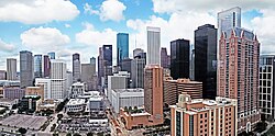
From the southwestern suburbs of Houston to Downtown Houston, US 59 is commonly referred to as the "Southwest Freeway", sometimes derisively as the "Southwest's Best Freeway." Supporting 371,000 vehicles per day, [3] it is one of the busiest freeways in the United States. US 59 is known as the "Eastex Freeway" in the north/northeast part of the Houston region. At the Mexican border, it ends at the World Trade International Bridge in Laredo, Texas. In Laredo, US 59 is co-signed with both I-69W and Loop 20, and has an intersection of I-35 which ends at the Juarez-Lincoln International Bridge. After crossing the bridge into Mexico, I-35 continues as Mexican Federal Highway 85 in Nuevo Laredo, which then runs through Mexico and Central America and ends in Panama at the Panama Canal.

Downtown Houston skyline along US 59 Panoramic Houston skyline.jpg
Downtown Houston skyline along US 59
Uptown Houston skyscrapers along US 59 Uptown Houston.jpg
Uptown Houston skyscrapers along US 59

Arkansas

In Arkansas, US 59 is concurrent with US 71 from I-30 at Texarkana to Acorn, and with US 270 from Acorn to the Oklahoma state line. The Third Loop was to be extended on I-49 from its original northern end to US 71 at the Texas state line opened on May 15, 2013, and was extended to State Line Road, where it intersects with US 59 and US 71 in Texas.

Oklahoma

US 59 and US 412 are co-signed for 10 miles (16 km) in Delaware County, Oklahoma.

US 59 is co-signed with US 270 from the Arkansas state line to Heavener and US 271 from Poteau to west of Spiro. It is also co-signed with US 64 in Sallisaw.

Kansas

US 59 freeway between Ottawa, Kansas, and Lawrence, Kansas U.S. 59 divided freeway in Kansas.jpeg
US 59 freeway between Ottawa, Kansas, and Lawrence, Kansas

US 59 enters the state just south of Chetopa and runs nearly directly north across the state. It runs concurrently with US 169 starting about five miles (8.0 km) south of Garnett and diverges north again immediately south of Garnett. The intersection immediately south of Garnett used to be a braided intersection with stop and yield signs. It was identified as a high-crash location in 2001, and was rebuilt as a roundabout that opened in April 2006. [4] The Kansas Department of Transportation is rebuilding or planning to rebuild several other rural intersections as roundabouts for increased safety. [5] [6] Until 2012, US 59 passed through Ottawa, Kansas, and had to be shut down or detoured every time the Marais Des Cygnes floodwall gates were closed across the highway. The highway now bypasses around Ottawa, running concurrently with I-35 for five miles (8.0 km) and using that highway's bridges over the Marais Des Cygnes. US 59 passes through Lawrence. The street name of US 59 in Lawrence is Iowa Street, then 6th Street as it joins US 40 and jogs east to cross the Kansas River near downtown. North of the U.S. 40 and 59 Bridges, it splits with US 40 as it joins US 24 briefly and jogs back west before resuming a northerly course. It continues north to Nortonville, then northeast to Atchison, where it crosses the Missouri River over the Amelia Earhart Bridge.

US 59 has been rebuilt and rerouted just to the east between Lawrence and Ottawa as a divided highway, as the former road was one of the most dangerous stretches of highway in the state. The project began in mid-2007, and was completed and opened to the public on October 17, 2012. [7]

Missouri

In Missouri, US 59 travels northerly through the northwest corner of the state, largely amidst the Missouri River Valley and Loess Hills. The highway crosses the Missouri River east of Atchison, Kansas at Winthrop and travels northeast towards St. Joseph. [8] In St. Joseph, the highway is paired with I-229 through downtown, and then departs from I-229 as Saint Joseph Avenue. It later joins with Bus. US 71 at its first junction with I-29 in Andrew County. US 59 and Bus. US 71 continue up to and through Savannah before reaching US 71, where the business route terminates, and US 59 continues west. US 59 then tracks with I-29 closely through Holt County, crossing it four separate times, until diverging northward at Craig. There it begins a very northerly route that it follows through the rest of the state. It passes through Fairfax and Tarkio before exiting the state 10 miles (16 km) north of Tarkio. [8] This last section of US 59 is immortalized in the Brewer and Shipley song "Tarkio Road".[ citation needed ]

Iowa

In Iowa, US 59 is a main north–south artery in the western part of the state. It enters Iowa south of Shenandoah and joins I-80 at Avoca. It passes through the county seats of Harlan, Denison, Cherokee, and Primghar. Except for small stretches of expressway near Avoca, Denison, and Holstein, the entire length of US 59 in Iowa is an undivided two-lane road. US 59 exits the state near Hawkeye Point, the highest point in the state of Iowa.

Minnesota

US 59 enters Minnesota south of Worthington, just one mile (1.6 km) east of Bigelow. It passes through rural western Minnesota for its entire length in the state. Some cities along the way include Slayton, Marshall, Clarkfield, Montevideo, and Morris. US 59 overlaps I-94/US 52 in the Fergus Falls area. North of Fergus Falls, US 59 passes through Pelican Rapids, Detroit Lakes, and Thief River Falls before ending at the Lancaster–Tolstoi border crossing on the Canadian border. US 59 runs for about 425 miles (684 km) through Minnesota.

The Minnesota section of US 59 is legally defined as all or part of Routes 265, 16, 17, 88, 66, 144, 3, 30, and 174 in Minnesota Statutes §§ 161.115(19), (75), and (196) and 161.114(2). [9] [10]

History

US 59 and State Highway 10 in Welch, Oklahoma US59 OK10 welch.jpg
US 59 and State Highway 10 in Welch, Oklahoma

In 1934, a coalition of government officials from Missouri, Iowa, and Minnesota agreed to sign the current US 59 as Highway 73 in an attempt to extend US 73 north from Atchison, Kansas. However, the American Association of State Highway Officials (AASHO) approved the route as US 59, instead.[ citation needed ]

The part in Missouri was defined in 1922 as Route 52 from Kansas to St. Joseph, Route 1 from St. Joseph to Tarkio, and Route 61 from Tarkio to Iowa. Route 61 became Route 9 in 1926, and Route 52 became part of Route 4 in 1927, and this portion became Route 18 in 1932, before being removed in favor of US 59 in the 1930s.

Historic termini

Before the 1950s, US 59 headed northwest to US 75 at Noyes, crossed the Red River of the North at St. Vincent, and terminated at US 81 in Pembina, North Dakota. A new highway and border crossing were built north of Lancaster on the present alignment in 1950. The former segment of US 59 between Lancaster and US 75 became CR 6, and the extremely short segment between US 75 and US 81 became MN 171 and ND 59. ND 59 still exists in Pembina from the state line to I-29.

From 1934 to 1935, the US 59 designation referred to a 50-mile-long (80 km) route across southeastern Minnesota, from Lake City, Minnesota, to the Iowa state line just short of Chester, Iowa. That entire route is now part of US 63, and nowhere close to the present US 59, established in 1935.[ citation needed ]

In 1933, much of the present US 59 and the entirety of US 96 in Texas were originally proposed to be part of US 71. Under this plan, discussed at a meeting of the United States Good Roads Association in Beaumont, US 71 was to be diverted out of Louisiana altogether and instead rerouted from the Texarkana area southward through East Texas. [11]

Future

A large portion of US 59 is proposed to become part of the future extension of I-69, I-69W and I-369 through Texas, allowing the current alignment and right-of-way to be upgraded without the need for government environmental studies or extensive eminent domain proceedings. [12]

Major intersections

Texas
World Trade International Bridge at the Mexican border
I-69W.svg I-69W in Laredo. The highways travel concurrently through the city.
I-35.svgUS 83.svg I-35  / US 83 in Laredo
I-69C (Future).svgUS 281.svg Future I-69C  / US 281 in George West
I-37.svg I-37 east of George West
US 181.svg US 181 in Beeville
US 183.svg US 183 in Goliad
I-69 (Future).svgI-69E (Future).svgI-69W (Future).svgUS 77.svg Future I-69  / Future I-69E  / Future I-69W  / US 77 southwest of Victoria. I-69/US 59 will travel concurrently to Houston. US 59/US 77 travels concurrently to south-southwest of Victoria.
US 87.svg US 87 in Victoria
I-69.svgI-610.svg I-69  / I-610 in Houston
I-45.svg I-45 in Houston
I-10.svgUS 90.svg I-10  / US 90 in Houston
I-69.svgI-610.svg I-69  / I-610 in Houston. I-69/US 59 will travel concurrently to Tenaha.
US 190.svg US 190 in Livingston
US 287.svg US 287 in Corrigan
US 69.svg US 69 in Lufkin. The highways travel concurrently through the city.
US 259.svg US 259 in Redfield
US 84.svg US 84 in Timpson. The highways travel concurrently to Tenaha.
I-69 (Future).svgI-369 (Future).svgUS 84.svgUS 96.svg Future I-69  / Future I-369 / US 84  / US 96 in Tenaha. I-369/US 59 will travel concurrently to Texarkana.
US 79.svg US 79 in Carthage. The highways travel concurrently to north of Carthage.
I-20.svg I-20 in Marshall
US 80.svg US 80 in Marshall
I-369.svg I-369 in Texarkana. I-369/US 59 travels concurrently to I-30.
US 67.svg US 67 in Texarkana
US 82.svg US 82 in Texarkana
I-30.svgI-369.svg I-30  / I-369 in Texarkana. I-30/US 59 travels concurrently to the Arkansas state line.
Arkansas
I-30.svgUS 71.svg I-30  / US 71 in Texarkana. US 59/US 71 travels concurrently to Acorn.
Texas
I-49.svg I-49 north of Texarkana
Arkansas
US 371.svg US 371 in Lockesburg. The highways travel concurrently to De Queen.
US 70.svg US 70 in Saline Township. The highways travel concurrently to De Queen.
US 278.svg US 278 in Wickes
US 71.svgUS 270.svg US 71  / US 270 in Acorn. US 59/US 270 travels concurrently to Heavener, Oklahoma.
Oklahoma
US 259.svg US 259 west-northwest of Page
US 271.svg US 271 in Poteau. The highways travel concurrently to west of Spiro.
I-40.svg I-40 in Sallisaw
US 64.svg US 64 in Sallisaw. The highways travel concurrently through the city.
US 62.svg US 62 in Westville
US 412.svg US 412 in West Siloam Springs. The highways travel concurrently to Kansas.
US 60.svgUS 69.svg US 60  / US 69 east-northeast of Afton. US 59/US 60 travels concurrently for approximately 0.6 miles (0.97 km). US 59/US 69 travels concurrently to north of Dotyville.
I-44.svgUS 60.svg I-44  / US 60 east-northeast of Afton
Kansas
US 166.svg US 166 in Chetopa. The highways travel concurrently through the city.
US 160.svg US 160 in Oswego. The highways travel concurrently to the Mount Pleasant–Fairview township line.
US 400.svg US 400 in Parsons
US 54.svg US 54 in Moran
US 169.svg US 169 in Welda Township. The highways travel concurrently to Washington Township.
I-35.svgUS 50.svg I-35  / US 50 in Ottawa. The highways travel concurrently to Ottawa Township.
US 56.svg US 56 in Willow Springs Township
US 40.svg US 40 in Lawrence. The highways travel concurrently through the city.
I-70.svg I-70 in Lawrence
US 24.svgUS 40.svg US 24  / US 40 in Lawrence. US 24/US 59 travels concurrently to Williamstown.
US 73.svg US 73 in Shannon Township. The highways travel concurrently to Atchison.
Missouri
I-229.svg I-229 in St. Joseph. The highways travel concurrently through the city.
US 36.svg US 36 in St. Joseph
I-29.svgUS 71.svg I-29  / US 71 in Jefferson Township
US 71.svg US 71 in Nodaway Township
I-29.svg I-29 in Jackson Township. The highways travel concurrently to Nodaway Township.
I-29.svg I-29 in Hickory Township
US 159.svg US 159 in Hickory Township
I-29.svg I-29 in Union Township
US 136.svg US 136 in Tarkio Township. The highways travel concurrently to Tarkio.
Iowa
US 34.svg US 34 in Indian Creek Township
US 6.svg US 6 in Belknap Township. The highways travel concurrently to Oakland.
I-80.svg I-80 in Avoca
US 30.svg US 30 in Denison. The highways travel concurrently through the city.
US 20.svg US 20 on the Logan–Griggs township line. The highways travel concurrently to Holstein.
US 18.svg US 18 on the Franklin–Lincoln township line. The highways travel concurrently to Sanborn.
Minnesota
I-90.svg I-90 in Worthington
US 14.svg US 14 in Custer Township
US 212.svg US 212 in Camp Release Township. The highways travel concurrently to Montevideo.
US 12.svg US 12 in Moyer Township
I-94.svgUS 52.svg I-94  / US 52 on the BuseDane Prairie township line. The highways travel concurrently to Fergus Falls Township.
US 10.svg US 10 in Detroit Lakes
US 2.svg US 2 in Knute Township
Manitoba Highway 59.svg PTH 59 at the Canadian border on the RichardvilleSt. Joseph township line

[13]

See also

References

  1. "New Highway Numbers". The St. Joseph News-Press. St. Joseph, Missouri. October 19, 1934. p. 21. Retrieved December 18, 2019 via Newspapers.com. Open Access logo PLoS transparent.svg
  2. Texas Department of Transportation. Traffic Counts (Map). Archived from the original on February 13, 2023. Retrieved December 12, 2007.
  3. Staff. "Houston" . Retrieved October 9, 2014.
  4. Church, David (May 11, 2007). Kansas: High Speed Approach Rural Roundabouts (PDF). Missouri Department of Transportation State Traffic & Safety Conference. Missouri Department of Transportation. Archived from the original (PDF) on March 3, 2016. Retrieved December 27, 2014.
  5. Myers, Ed; Waltman, Eric (February 7, 2003). "Intersection Improvement Feasibility Study US 169/US 59 Intersection: Garnett, Kansas" (PDF). Kittelson & Associates. Archived from the original (PDF) on March 6, 2012. Retrieved February 28, 2015 via Kansas Department of Transportation.
  6. King, Steve (May 22, 2005). KDOT (PDF). National Roundabout Conference. Kansas Department of Transportation . Retrieved February 28, 2015.
  7. Belt, Mike (June 21, 2007). "End of the Road for 'Silent Killer'". Lawrence Journal-World . Retrieved February 28, 2015.
  8. 1 2 "Official State Highway Map Section 1" (PDF). MODOT. 2025. Retrieved February 1, 2026.
  9. "§161.115". Minnesota Statutes. 2006. Retrieved December 26, 2017.
  10. "§161.114". Minnesota Statutes. 2006. Retrieved December 26, 2017.
  11. "Road Route Change Attempt Protested". The Times-Picayune. New Orleans. October 13, 1933. p. 27.
  12. I69Info.com: "New" and "Old" Terrain
  13. Rand McNally (2014). The Road Atlas (Walmart ed.). Chicago: Rand McNally. pp. 10, 38, 41, 54–55, 58, 83, 100–101. ISBN   978-0-528-00771-2.
Template:Attached KML/U.S. Route 59
KML is from Wikidata
Browse numbered routes
Texas 57.svg SH 57 TX Texas 59.svg SH 59
Arkansas 58.svg AR 58 AR Arkansas 59.svg AR 59
Oklahoma State Highway 58.svg SH-58 OK Oklahoma State Highway 59.svg SH-59
K-58.svg K-58 KS K-60.svg K-60
MO-58.svg Route 58 MO MO-59.svg Route 59
Elongated circle 58.svg Iowa 58 IA Elongated circle 60.svg Iowa 60
MN-58.svg MN 58 MN MN-60.svg MN 60