
The United States Numbered Highway System is an integrated network of roads and highways numbered within a nationwide grid in the contiguous United States. As the designation and numbering of these highways were coordinated among the states, they are sometimes called Federal Highways, but the roadways were built and have always been maintained by state or local governments since their initial designation in 1926.

U.S. Route 66 or U.S. Highway 66 was one of the original highways in the United States Numbered Highway System. It was established on November 11, 1926, with road signs erected the following year. The highway, which became one of the most famous roads in the United States, ran from Chicago, Illinois, through Missouri, Kansas, Oklahoma, Texas, New Mexico, and Arizona before terminating in Santa Monica in Los Angeles County, California, covering a total of 2,448 miles (3,940 km).

U.S. Route 91 or U.S. Highway 91 is a 172.7-mile-long (277.9 km) north–south United States highway running from Brigham City, Utah, to Idaho Falls, Idaho, in the U.S. states of Idaho and Utah. Despite the "1" as the last digit in the number, US 91 is no longer a cross-country artery, as it has mostly been replaced by Interstate 15. The highway currently serves to connect the communities of the Cache Valley to I-15 and beyond. Prior to the mid-1970s, US 91 was an international commerce route from Long Beach, California, to the Canada–US border north of Sweetgrass, Montana. US 91 was routed on the main streets of most of the communities it served, including Las Vegas Boulevard in Las Vegas and State Street in Salt Lake City. From Los Angeles to Salt Lake, the route was built along the corridor of the Arrowhead Trail. A portion of the highway's former route in California is currently State Route 91.

U.S. Route 54 is an east–west United States Highway that runs northeast–southwest for 1,197 miles (1,926 km) from El Paso, Texas, to Griggsville, Illinois. The Union Pacific Railroad's Tucumcari Line runs parallel to US 54 from El Paso to Pratt, Kansas, which comprises about two-thirds of the route. Truckers refer to this road as "The Bee Line."

A concurrency in a road network is an instance of one physical roadway bearing two or more different route numbers. When two roadways share the same right-of-way, it is sometimes called a common section or commons. Other terminology for a concurrency includes overlap, coincidence, duplex, triplex, multiplex, dual routing or triple routing.
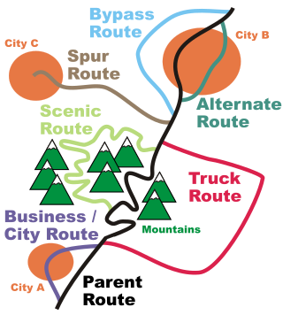
A business route in the United States is a short special route that branches off a parent numbered highway at its beginning, continues through the central business district of a nearby city or town, and finally reconnects with the same parent numbered highway at the business route's end. Their designation is often intended to direct traffic to the business districts bypassed when a new highway is constructed some distance away.

A supplemental route is a state secondary road in the U.S. state of Missouri, designated with letters. Supplemental routes were various roads within the state which the Missouri Department of Transportation was given in 1952 to maintain in addition to the regular routes, though lettered routes had been in use from at least 1932. The four types of roads designated as Routes are:

Delaware Route 273 (DE 273) is a state highway in New Castle County, Delaware. The route runs from Maryland Route 273 (MD 273) at the Maryland border near Newark east to DE 9 and DE 141 in New Castle. The route heads through suburban areas between Newark and New Castle as a multilane road, passing through Ogletown and Christiana. DE 273 intersects DE 896 in downtown Newark; DE 2/DE 72 on the eastern edge of Newark; DE 4 in Ogletown; Interstate 95 (I-95), DE 7, and DE 1 in Christiana; DE 37 in Pleasantville; and DE 58 and U.S. Route 13 (US 13)/US 40 in Hares Corner.

Iowa Highway 25 (Iowa 25) is a north–south highway in the southwest and west-central portion of the state. It begins at Iowa 2 seven miles (11 km) south of Clearfield. It heads north along a two-lane road through Creston, Greenfield, and Guthrie Center on its way to its northern end at U.S. Route 30 (US 30) near Scranton.

Delaware Route 72 (DE 72) is a state highway located in New Castle County, Delaware. The route runs from DE 9 near Delaware City north to DE 7 in Pike Creek. The highway runs through suburban areas of northern New Castle County, passing through the eastern part of Newark. DE 72 intersects U.S. Route 13 (US 13), DE 7, and DE 1 near Delaware City, DE 71 in Williamsburg, US 40 east of Glasgow, and DE 4, DE 2, and DE 273 in Newark. Parts of DE 72 were built as a state highway during the 1930s. By the 1940s, the route was designated from DE 2 in Newark north to DE 7 in Pike Creek along Paper Mill Road. The route was extended south to DE 9 in the 1960s. In 1980, the alignment was shifted to the east through Newark to bypass an at-grade railroad crossing on Chapel Street.

Highway 77 is a north–south state highway in Northeast Arkansas. The route of 66.70 miles (107.34 km) runs from US Highway 70 (US 70) in West Memphis north through small towns and agricultural areas of the Arkansas Delta to Missouri Route 108 at the Missouri state line. It is generally a low-traffic road except in West Memphis. Created during the 1926 Arkansas state highway numbering, the route was extended in the 1950s and 1960s, including along a former alignment of US 61. AR 77 does not have any spur or business routes.
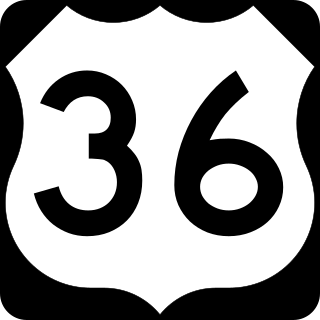
U.S. Route 36 in the state of Missouri is an expressway with many freeway sections, connecting Kansas to Illinois. From Cameron to the Illinois state line, it forms part of the principal route between Kansas City and Chicago, known as the Chicago–Kansas City Expressway.

Highway 115 is a state highway in Northeast Arkansas. The route begins at US Highway 167 and Highway 58 in Cave City and runs northeast to Missouri Route 21 near Doniphan, Missouri, including a 14 miles (23 km) concurrency with US 62/US 412 between Imboden and Pocahontas. The highway is maintained by the Arkansas Department of Transportation (ARDOT).
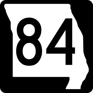
Route 84 is a state highway in the Missouri bootheel. The route starts at Arkansas Highway 90 over the St. Francis River on the Arkansas–Missouri state line. The road travels eastward to Kennett, where it becomes concurrent with U.S. Route 412. East of Kennett, the concurrent routes travel eastward on a divided highway to Hayti Heights, where the concurrency ends. Route 84 travels through Hayti Heights and Hayti, and it crosses Interstate 55 (I-55) and US 61. The route then travels southeastwards to Caruthersville, and bypasses the central area of the city. In the southern part of Caruthersville, Route 84 ends at an interchange with I-155 and US 412.

Several special routes of U.S. Route 40 exist. In order from west to east they are as follows.

A total of eight special routes of U.S. Route 65 exist, divided between the U.S. states of Arkansas and Missouri. Currently, they are all business loops, although a spur route in Pine Bluff, Arkansas and bypass routes in Baton Rouge, Louisiana and Springfield, Missouri both existed in the past.

Several special routes of U.S. Route 30 exist. In order from west to east they are as follows.

U.S. Route 59 (US-59) is a part of the U.S. Highway System that runs from the Mexico–US border in Laredo, Texas, as a continuation of Mexican Federal Highway 85D north to the Lancaster–Tolstoi Border Crossing on the Canada–US border, where it continues as Manitoba Highway 59. In the U.S. state of Kansas, US-59 is a main north–south highway that travels from Chetopa to Atchison.

U.S. Highway 75 (US 75) is a United States Highway in northwestern Iowa. It begins at the Missouri River on a bridge with Interstate 129 (I-129) and US 20. Immediately upon landing in Iowa from Nebraska, I-129 ends at an interchange with I-29. US 20 and US 75 continue around Sioux City on a four-lane expressway until US 20 exits to the east. US 75 heads to the north-northeast, parallel to the Floyd River, until Le Mars. There, Iowa Highway 60 (Iowa 60) continues northeastward on the expressway while US 75 heads due north. Near Hull, it is briefly overlapped by US 18. It leaves the state and enters Minnesota north of Rock Rapids.

The Delaware State Route System consists of roads in the U.S. state of Delaware that are maintained by the Delaware Department of Transportation (DelDOT). The system includes the portions of the Interstate Highway System and United States Numbered Highways system located in the state along with state routes and other roads maintained by DelDOT. All roads maintained by the state are assigned a maintenance road number that is only marked on little white markers at intersections and on auxiliary plates below warning signs approaching intersections. These numbers are only unique in a specific county; some roads can be designated with multiple road numbers, and numbers do not necessarily correspond to the signed Interstate, U.S., or state route numbers. DelDOT maintains a total of 5,386.14 miles (8,668.15 km) of roads, comprising 89 percent of the roads within the state. Some large bridges in the state are maintained by other agencies including the U.S. Army Corps of Engineers and the Delaware River and Bay Authority. Roads in the system include multilane freeways, multilane surface divided highways, and two-lane undivided roads serving urban, suburban, and rural areas. Some of the roads maintained by DelDOT are toll roads, in which motorists must pay to use.


