
The United States Virgin Islands, officially the Virgin Islands of the United States, are a group of Caribbean islands and a territory of the United States. The islands are geographically part of the Virgin Islands archipelago and are located in the Leeward Islands of the Lesser Antilles. The islands have a tropical climate.
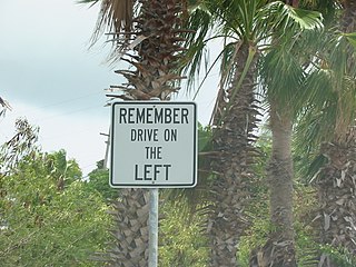
The United States Virgin Islands (USVI) is the only place under United States jurisdiction where the rule of the road is to drive on the left. However, virtually all passenger vehicles are left hand drive due to imports of U.S. vehicles.

The United States Numbered Highway System is an integrated network of roads and highways numbered within a nationwide grid in the contiguous United States. As the designation and numbering of these highways were coordinated among the states, they are sometimes called Federal Highways, but the roadways were built and have always been maintained by state or local governments since their initial designation in 1926.

Charlotte Amalie, located on St. Thomas, is the capital and the largest town of the United States Virgin Islands. It is the anchor of the subdistrict of Charlotte Amalie that is composed of the town of Charlotte Amalie, the census-designated place (CDP) of Charlotte Amalie West, and the CDP of Charlotte Amalie East. It was founded in 1666 as Taphus. In 1691, the town was renamed to Charlotte Amalie after the Danish queen Charlotte Amalie of Hesse-Kassel (1650–1714). It has a deep-water harbor that was once a haven for pirates and is now one of the busiest ports of call for cruise ships in the Caribbean, with about 1.5 million-plus cruise ship passengers landing there annually. Protected by Hassel Island, the harbor has docking and fueling facilities, machine shops, and shipyards and was a U.S. submarine base until 1966. The town has been inhabited for centuries. When Christopher Columbus arrived in 1493, the area was inhabited by Caribs, Arawaks, Ciboney and Taíno native peoples. It is on the southern shore at the head of Saint Thomas Harbor. In 2020 the subdistrict of Charlotte Amalie had a population of 14,477 which makes it the most densly populated area in the Virgin Islands Archipelago with the town of Charlotte Amalie as the anchor of "the City". Hundreds of ferries and yachts pass by the town each week.
Saint Croix is an island in the Caribbean Sea, and a county and constituent district of the United States Virgin Islands (USVI), an unincorporated territory of the United States.

A spur route is a short road forming a branch from a longer, more important road such as a freeway, Interstate Highway, or motorway. A bypass or beltway is not considered a spur route as it typically reconnects with another or the same major road.
A routenumber, designation or abbreviation is an identifying numeric designation assigned by a highway authority to a particular stretch of roadway to distinguish it from other routes and, in many cases, also to indicate its classification, general geographical location and/or orientation. The numbers chosen may be used solely for internal administrative purposes; however, in most cases they are also displayed on roadside signage and indicated on maps.

The State Highway System of the U.S. state of Florida comprises the roads maintained by the Florida Department of Transportation (FDOT) or a toll authority. The components are referred to officially as state roads, abbreviated as SR.
The Massachusetts State Highway System in the U.S. Commonwealth of Massachusetts is a system of state-numbered routes assigned and marked by the highway division of the Massachusetts Department of Transportation (MassDOT). U.S. Highways and Interstate Highways are included in the system; the only overlaps are with the end-to-end U.S. Route 3 and Route 3 and the far-apart Interstate 295, shared with Rhode Island, and Route 295, shared with New York State. A state highway in Massachusetts is a road maintained by the state, which may or may not have a number. Not all numbered routes are maintained or owned by the state.

Japan has a nationwide system of national highways distinct from the expressways. The Ministry of Land, Infrastructure, Transport and Tourism and other government agencies administer the national highways. Beginning in 1952, Japan classified these as Class 1 or Class 2. Class 1 highways had one- or two-digit numbers, while Class 2 highways had three-digit numbers. For example, routes 1 and 57 were Class 1 highways while 507 was a Class 2 highway.
Scouting in the United States Virgin Islands has a long history, from the 1920s to the present day, serving thousands of youth in programs that suit the environment in which they live.

The North Carolina Highway System consists of a vast network of Interstate, United States, and state highways, managed by the North Carolina Department of Transportation. North Carolina has the second largest state maintained highway network in the United States because all roads in North Carolina are maintained by either municipalities or the state. Since counties do not maintain roads, there is no such thing as a "county road" within the state.
In 1955, Louisiana passed a law that undertook a comprehensive revision to the state highway classification and numbering system. The new system designated roads by importance to travel patterns and rectified the previous numbering system under new unified designations.

Highway 10 is a road on St. John in the U.S. Virgin Islands. Usually referred to as Center Line Road by locals, as it runs through the center of the island, Highway 10 runs from Highway 20 in Cruz Bay across St. John, entering Virgin Islands National Park along the way. Route 10 has three auxiliary routes, Highway 104, Highway 107, and Highway 108.
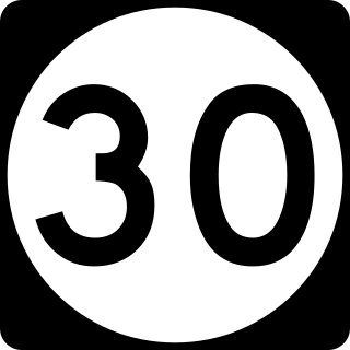
Highway 30 is a major road on St. Thomas, USVI.

Highway 37 is a road on St. Thomas. Running just over two miles from a junction with Highway 33 to the Hull Bay beach, the road's function is to serve the north central part of St. Thomas. When combined with stretches of Highway 404 and Highway 301, it provides a safer but longer route to the west side of the island instead of using the clogged Highway 30 or the mountainous Highway 40 and Highway 33.

Highway 38 is a major road on St. Thomas, U.S. Virgin Islands. Starting at Highway 35 in the eastern part of Charlotte Amalie, the road runs in an east–west direction. Along its path, Highway 38 serves as the southern terminus of Highway 39 and Highway 42, and the northern terminus of Highway 32. Past Highway 42, the road turns south and runs along the eastern coast of St. Thomas. Finally, as the road turns back west near Red Hook, its designation changes to Highway 32.
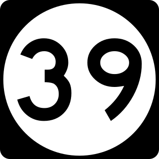
Highway 39 is a road on St. Thomas, USVI. Starting at Highway 42 near the Mahogany Run Golf Course, it runs in a north–south direction across the eastern portion of the island. After a brief Concurrency with Highway 40, the road ends at Highway 38 a few miles east of Charlotte Amalie.

