
New York State Route 25A (NY 25A) is a state highway on Long Island in New York, United States. It serves as the main east–west route for most of the North Shore of Long Island, running for 73 miles (117 km) from Interstate 495 (I-495) at the Queens–Midtown Tunnel in the New York City borough of Queens to NY 25 in Calverton, Suffolk County. The highway is a northern alternate route of NY 25, which follows a more inland routing along Jericho Turnpike.
North Carolina Highway 226 (NC 226) is a primary state highway in the U.S. state of North Carolina. Traveling north–south through Western North Carolina, it connects the cities and towns of Grover, Shelby, Marion, Spruce Pine and Bakersville. It also a scenic byway in the South Mountains area and connects with the summer colony of Little Switzerland, via NC 226A.
North Carolina Highway 16 (NC 16) is a 143.8-mile primary state highway in the U.S. state of North Carolina. Traveling in a north–south direction, it connects the cities and towns of Charlotte, Newton, Conover, Taylorsville, Wilkesboro and Jefferson, linking the Charlotte metropolitan area with the mountainous High Country. NC 16 is part of a three-state route 16 that connects the Charlotte region with northwestern West Virginia.

New York State Route 304 (NY 304), also known as "Rockland County Clerk Paul Piperato Memorial Highway", as well as Pearl Street for its first half a mile and Main Street for other parts, is a north–south state highway located in central Rockland County, New York, in the United States. The 10.38-mile (16.70 km) route begins at the New Jersey–New York border in Pearl River and ends at an intersection with U.S. Route 9W (US 9W) in the community of Congers. The route is a main route through Rockland County, intersecting NY 59 and indirectly connecting to the New York State Thruway and the Palisades Interstate Parkway (PIP) in Nanuet. NY 304 has three distinct sections: a freeway that extends from Pearl River to Nanuet, an at-grade section between Nanuet and New City, and a surface bypass linking New City to Haverstraw.

New York State Route 303 (NY 303) is a north–south state highway in eastern Rockland County, New York, in the United States. It begins at the New Jersey state line in the hamlet of Tappan and runs generally northward for 10.92 miles (17.57 km) to an intersection with U.S. Route 9W (US 9W) in Clarkstown. The route has connections to the Palisades Interstate Parkway and the New York State Thruway, the latter carrying Interstate 87 (I-87) and I-287. NY 303 was assigned as part of the 1930 renumbering of state highways in New York, and only minor realignments have occurred since that time.

New York State Route 37 (NY 37) is a state highway in the North Country of New York in the United States, extending for 127.40 miles (205.03 km) on a west–east axis. The western terminus of the route is at an intersection with U.S. Route 11 (US 11) in Pamelia, Jefferson County. Its eastern terminus is at a junction with US 11, NY 11B, and NY 30 in Malone, Franklin County. In between the termini, NY 37 passes through Ogdensburg and Massena. It is a two-lane, nondivided, full access roadway for most of its entire length, except for portions between Massena and western Franklin County, where the route widens to a four-lane divided highway.

State Route 333 (SR 333) is a 29.2-mile-long (47.0 km) south-to-north state highway located entirely within Brooks County in the south-central part of the U.S. state of Georgia. It connects the Florida state line, where the roadway continues as Florida State Road 53, with New Rock Hill, where it intersects SR 133, via Quitman.

North Carolina Highway 109 (NC 109) is a north–south state highway in North Carolina. It primarily connects small towns in the central Piedmont region of the state. The 117-mile (188 km) route is a two-lane road for most of its length, but the segment between Winston-Salem and Thomasville is being upgraded to a divided 4-lane highway, as it is a major route between the two cities. The central segment of NC 109 passes through the Uwharrie Mountains and the Uwharrie National Forest.

Maryland Route 322 (MD 322) is a state highway in the U.S. state of Maryland. Known as Easton Parkway, the highway runs 5.12 miles (8.24 km) on the west side of Easton between two junctions with U.S. Route 50 (US 50). MD 322 serves as a bypass of downtown Easton for traffic between US 50 and highways to western Talbot County, including MD 33 toward Saint Michaels and Tilghman Island and MD 333 toward Oxford. Easton Parkway was constructed in the mid to late 1960s. The state highway was originally designated as part of MD 33; MD 322 became the sole designation on the bypass in 1978.
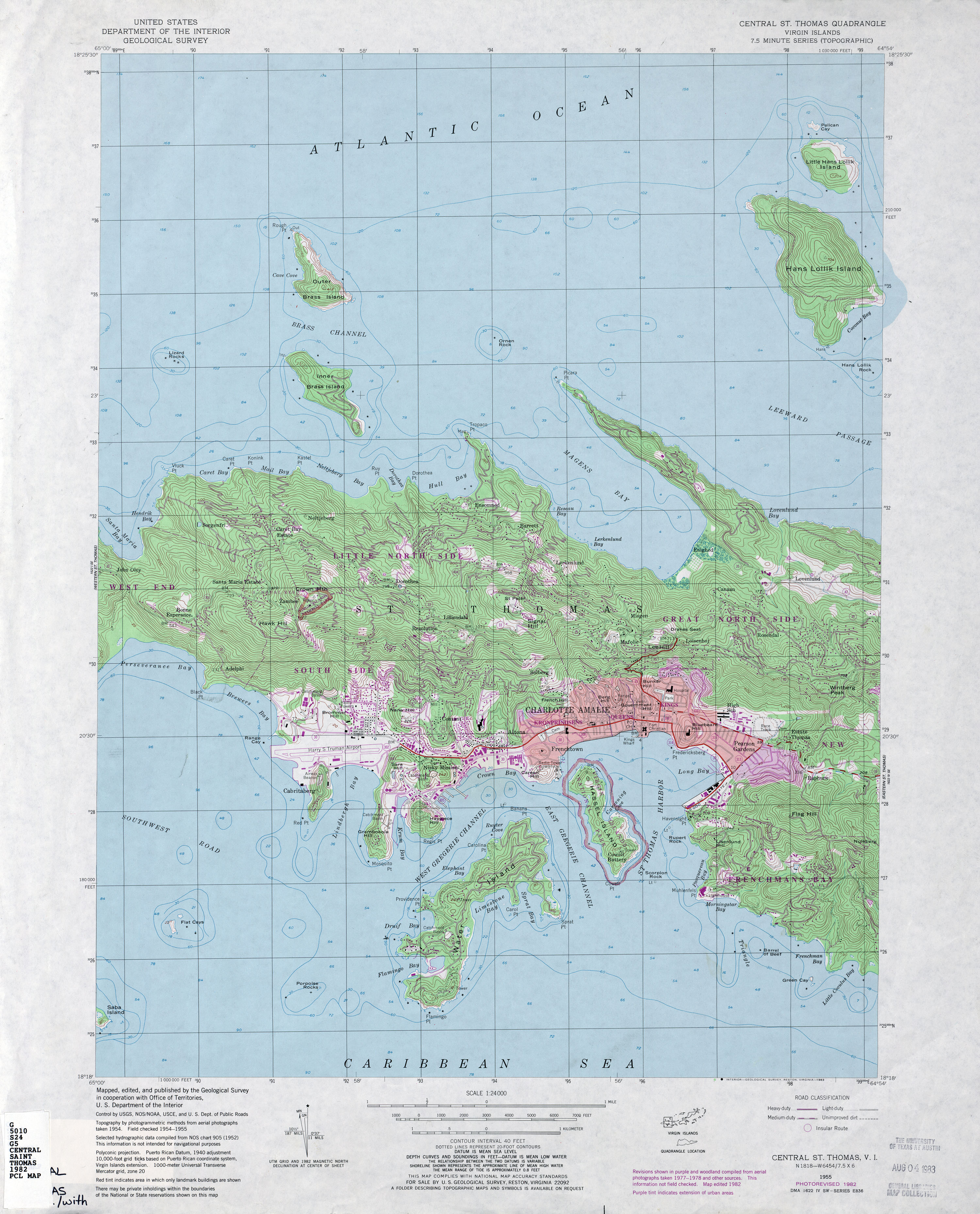
Highway 30 is a major road on St. Thomas, USVI.

U.S. Virgin Islands Highway 32 (VI 32) is a primary territorial highway on the island of St. Thomas in the United States Virgin Islands. It runs about 3.9 miles (6.3 km) from VI 38 in Tutu to VI 38 at the Red Hook Ferry Terminal in Red Hook. The highway travels in a southeastern direction between its termini, intersecting VI 30 in Nadir and traveling along the coastline near Benner Bay. VI 32 serves as an access route between Charlotte Amalie and the southeastern areas of St. Thomas.

Highway 37 is a road on St. Thomas. Running just over two miles from a junction with Highway 33 to the Hull Bay beach, the road's function is to serve the north central part of St. Thomas. When combined with stretches of Highway 404 and Highway 301, it provides a safer but longer route to the west side of the island instead of using the clogged Highway 30 or the mountainous Highway 40 and Highway 33.

Highway 38 is a major road on St. Thomas, U.S. Virgin Islands. Starting at Highway 35 in the eastern part of Charlotte Amalie, the road runs in an east–west direction. Along its path, Highway 38 serves as the southern terminus of Highway 39 and Highway 42, and the northern terminus of Highway 32. Past Highway 42, the road turns south and runs along the eastern coast of St. Thomas. Finally, as the road turns back west near Red Hook, its designation changes to Highway 32.
Highway 39 is a road on St. Thomas, USVI. Starting at Highway 42 near the Mahogany Run Golf Course, it runs in a north–south direction across the eastern portion of the island. After a brief Concurrency with Highway 40, the road ends at Highway 38 a few miles east of Charlotte Amalie.
Highway 40 is a road on St. Thomas, USVI. Starting at a junction with Highway 42 on the eastern shore of St. Thomas, the road is about seven miles (11 km) long. Highway 40 serves several small towns in the eastern and central parts of St. Thomas. After the junction with Highway 42, the road continues west for a few miles, overlapping Highway 37 along the way, until it turns southward to meet Highway 33. Highway 40 then starts its descent into Charlotte Amalie. It enters the town on Gamle Norsidevei, until it meets Prindsesse Gade, which is one-way westbound. Traffic is directed onto Prindsesse to Nye Norsidevei, which is one-way southbound, which then meets Dronnigens Gade. Traffic on Dronnigens Gade wishing to access Highway 40 must turn right on General Gade, left on Prindsesse, and finally right onto Gamle Norsidevei.
King's Highway 136, commonly referred to as Highway 136, was a provincially maintained highway in the Canadian province of Ontario that connected former Highway 24 near Caledon with Highway 9 in Orangeville. The majority of the route was located in the Regional Municipality of Peel; however, the section in Orangeville was in Dufferin County. The route of Highway 136 was originally part of Highway 24; it was created in 1962 when Highway 24 was rerouted along Highway 51. The highway remained unchanged until 1997, when it was transferred to the Regional Municipality of Peel and the Town of Orangeville.

North Carolina Highway 48 (NC 48) is a primary state highway in the U.S. state of North Carolina that principally connects the cities of Rocky Mount and Roanoke Rapids. The route offers an alternative to US 301 and I-95.
Louisiana Highway 103 is a state highway in St. Landry Parish, Louisiana, United States, that spans 39.5 miles (63.6 km) in a wide semi-circle around the north side of Opelousas. The route is not bannered but runs in an overall west–east direction from U.S. Highway 190 near Lawtell to LA 31 in Leonville. Along the way, it passes through the towns of Washington and Port Barre.

Louisiana Highway 107 is a state highway located in central Louisiana that runs 65.0 miles (104.6 km) in a north–south direction from U.S. Highway 71 in Morrow to a junction with LA 1250 in Pineville at the Pineville Expressway. Along the way, LA 107 services Cottonport, Mansura, and Marksville, intersecting routes such as LA 29, LA 114, and LA 1. LA 107 has significant concurrencies with both LA 1 and LA 115 in the vicinity of Marksville.

