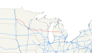
U.S. Route 10 or U.S. Highway 10 (US 10) is an east–west United States highway formed in 1926. Though it never became the cross-country highway suggested by the "0" as the last digit of its route number, US 10 was one of the original long-haul highways, running from Detroit, Michigan, to Seattle, Washington, but then losing much of its length when new Interstate Highways were built on top of its right-of-way. In 2010, its length was 565 miles (909 km).

U.S. Route 319 is a spur of U.S. Route 19. It runs for 303 miles (488 km) from the foot of the John Gorrie Memorial Bridge across from downtown Apalachicola, Florida to US 1/SR 4 in Wadley, Georgia, through the Panhandle of Florida and the southern portion of Georgia.

State Route 9 is a mainly rural and mountainous route in the U.S. state of California that travels 35 miles (56 km) from SR 1 in Santa Cruz to SR 17 in Los Gatos, passing through the San Lorenzo Valley and the Saratoga Gap. Daily traffic is between 3,200 and 34,500 cars.

California State Route 35, generally known as Skyline Boulevard, is a mostly two-lane road running along the ridge of the Santa Cruz Mountains from the low point of Highway 17 near Lexington Reservoir in Santa Clara County to State Route 1 just south of Daly City in San Mateo County, where it crosses SR 1 and loops around Lake Merced to become Sloat Boulevard in San Francisco.

State Route 259 is a primary state highway in the U.S. state of Virginia. The state highway runs a total of 26.80 miles (43.13 km) in two sections. The southern section, in northern Rockingham County, has a length of 21.81 miles (35.10 km) from Interstate 81 (I-81) and U.S. Route 11 at Mauzy through Broadway to the West Virginia state line into Mathias. The northern section, in western Frederick County, covers 4.99 miles (8.03 km) from the West Virginia state line north to US 50 at Gore. The two sections of SR 259 are joined by West Virginia Route 259.
Route 1 is a highway in the Canada province of Newfoundland and Labrador, and is the easternmost stretch of the Trans-Canada Highway. Route 1 is the primary east-west road on the island of Newfoundland.
Tertiary Highway 811, commonly referred to as Highway 811, is the longest of Ontario's tertiary highways, and the highest posted route number in the province. The route encounters no named roads along its route, aside from its eastern terminus at Secondary Highway 527. It extends 59 kilometres (37 mi) westward into the wilderness, ending at a bridge over the Weaver River. The route was designated in 1976 with the intention of extending it further west, but this extension has yet to be constructed.
King's Highway 130, commonly known as Highway 130, is a provincially maintained highway in the Canadian province of Ontario. It begins at a junction with Highway 61 and travels 15.4 km (9.6 mi) north-west to the Trans-Canada Highway, Highway 11 and Highway 17, west of Thunder Bay. Highway 130 is a short connecting highway, and passes entirely through the outskirts of Thunder Bay, connecting several minor communities and providing a shortcut for traffic travelling from the south to the west or vice versa. The speed limit along the highway is 80 km/h (50 mph); it is patrolled by the Ontario Provincial Police.
Highway 32 is a road on St. Thomas, USVI. It runs about four miles (6 km) from Highway 38 in Tutu to Red Hook, the easternmost point of the island, where its designation changes back to Highway 38. Along the way, Highway 32 meets Highway 30 near the town of Nadir; though most traffic will have used the quicker Highway 38 into Charlotte Amalie, unless they are traveling from the south.
Highway 33 is a road on St. Thomas, USVI. It runs from Highway 30 near Frenchtown and takes a northerly path toward Crown Mountain. The road takes a circuitous route around the mountain; the route initially bypasses it to the west, then swings east and follows the mountain's north side. Highway 33 then intersects Highway 333, which provides access to St. Thomas' north and east sides, and it takes a southeasterly turn to meet Highway 40. Highway 33 continues east-southeast, intersecting Highway 379 before ending at Highway 35.
Highway 37 is a road on St. Thomas. Running just over two miles from a junction with Highway 33 to the Hull Bay beach, the road's function is to serve the north central part of St. Thomas. When combined with stretches of Highway 404 and Highway 301, it provides a safer but longer route to the west side of the island instead of using the clogged Highway 30 or the mountainous Highway 40 and Highway 33.
Highway 38 is a major road on St. Thomas, U.S. Virgin Islands. Starting at Highway 35 in the eastern part of Charlotte Amalie, the road runs in an east–west direction. Along its path, Highway 38 serves as the southern terminus of Highway 39 and Highway 42, and the northern terminus of Highway 32. Past Highway 42, the road turns south and runs along the eastern coast of St. Thomas. Finally, as the road turns back west near Red Hook, its designation changes to Highway 32.
Highway 39 is a road on St. Thomas, USVI. Starting at Highway 42 near the Mahogany Run Golf Course, it runs in a north–south direction across the eastern portion of the island. After a brief multiplex with Highway 40, the road ends at Highway 38 a few miles east of Charlotte Amalie.
Highway 40 is a road on St. Thomas, USVI. Starting at a junction with Highway 42 on the eastern shore of St. Thomas, the road is about seven miles (11 km) long. Highway 40 serves several small towns in the eastern and central parts of St. Thomas. After the junction with Highway 42, the road continues west for a few miles, multiplexing with Highway 37 along the way, until it turns southward to meet Highway 33. Highway 40 then starts its descent into Charlotte Amalie. It enters the town on Gamle Norsidevei, until it meets Prindsesse Gade, which is one-way westbound. Traffic is directed onto Prindsesse to Nye Norsidevei, which is one-way southbound, which then meets Dronnigens Gade. Traffic on Dronnigens Gade wishing to access Highway 40 must turn right on General Gade, left on Prindsesse, and finally right onto Gamle Norsidevei.
Route 42 is a major arterial road located in Winnipeg, Manitoba. It connects the suburbs of North Kildonan, East Kildonan, Fort Rouge, Fort Garry, and St. Norbert with the city's downtown core. In the north, it is a continuation of Manitoba Provincial Road 204; in the south, it is a continuation of PTH 75, also known as the Lord Selkirk Highway.

Arkansas Highway 75 is a north–south state highway in Arkansas. The route runs 42.62 miles (68.59 km) from Highway 50 north to Interstate 555/U.S. Route 63/US 63B/AR 14.
Tourist Drives in Western Australia are routes through areas of scenic or historic significance, designated by route markers with white numbers on a brown shield. Tourist Drives were introduced into Western Australia while Eric Charlton was the state government Minister for Transport in the 1990s. The 28 numbered routes collectively traverse more than 2,000 kilometres (1,200 mi) across the state. In addition to the Tourist Drives, there are unnumbered routes such as the Golden Pipeline Heritage Trail, and local governments may designate and maintain local scenic drives, generally unnamed and unnumbered.
King's Highway 74, commonly referred to as Highway 74, was a provincially maintained highway in the Canadian province of Ontario that travelled north from Highway 3 at New Sarum to Middlesex County Road 29 on the outskirts of London. The 22.4-kilometre-long (13.9 mi) was assumed by the province in September 1937. Aside from paving and the construction of an interchange with Highway 401, it remained generally unchanged for the next six decades until it was decommissioned in 1997 and transferred to Elgin County and Middlesex County. The road has since been redesignated as Elgin County Road 74 and Middlsex County Road 74.