 | ||||
|---|---|---|---|---|
| Route information | ||||
| Maintained by USVI DPW | ||||
| Length | 14.5 mi [1] (23.3 km) | |||
| Major junctions | ||||
| West end | Dead end on western part of St. Thomas | |||
| East end | ||||
| Highway system | ||||
USVI Highways
| ||||
| ||||
Highway 30 is a major road on St. Thomas, USVI.
| | ||||
|---|---|---|---|---|
| Route information | ||||
| Maintained by USVI DPW | ||||
| Length | 14.5 mi [1] (23.3 km) | |||
| Major junctions | ||||
| West end | Dead end on western part of St. Thomas | |||
| East end | ||||
| Highway system | ||||
USVI Highways
| ||||
| ||||
Highway 30 is a major road on St. Thomas, USVI.
The road begins as Fortuna Road at a dead end on the westernmost part of St. Thomas. Highway 30 starts out heading northwards, but quickly turns east and runs through the quiet western section of the island. After meeting Highway 301, the road heads in a southeasterly direction, passing the University of the Virgin Islands and Cyril E. King Airport (accessed via Highway 302). Soon after the airport, Highway 30 meets Highway 33, a road which serves the northern part of St. Thomas, as well as Highway 308, a road which runs parallel to Highway 30 through the heart of Charlotte Amalie. Highway 30 runs along the Caribbean Sea at this point, and travelers can see the cruise ships docked at Charlotte Amalie's harbor. After leaving the immediate vicinity of Charlotte Amalie and becoming one of the busiest roads on the islands, Highway 30 passes Havensight, a large shopping center. This part of the road is prone to traffic jams, due to a combination of the large number of shoppers, poorly timed lights, and a complex intersection with Highway 313. After passing Havensight, Highway 30 quickly becomes a residential road, with many houses on either side. Finally, the road meets Highway 32 in the town of Nadir and comes to an end.
This section contains a table that is missing mileposts for one or more junctions. |
| Location | mi | km | Destinations | Notes | |
|---|---|---|---|---|---|
| St. Thomas | 0.00 | 0.00 | Dead end | Terminus | |
| Charlotte Amalie | |||||
| Nadir | Terminus | ||||
| 1.000 mi = 1.609 km; 1.000 km = 0.621 mi | |||||
Highway 301 | |
|---|---|
| Location | |
| Length | 1.0 mi [2] (1.6 km) |
Highway 301 is a short road on St. Thomas, USVI. The purpose of the road is to connect Highway 33 with Highway 30. Currently, if Highway 301 did not exist, travelers would have to travel southeast along Highway 33 to Charlotte Amalie, then back northwest along Highway 30.
Highway 302 | |
|---|---|
| Location | Cyril E. King Airport |
| Length | 1.2 mi [3] (1.9 km) |
Highway 302 is a minor road on St. Thomas, USVI. Its function is to provide access to Cyril E. King Airport.
Highway 303 | |
|---|---|
| Location | |
| Length | 1.2 mi [4] (1.9 km) |
Highway 303 [5] is a road on St. Thomas, USVI. Its route takes it up the east side of the University of the Virgin Islands, then through a residential area to Highway 33.
Highway 304 | |
|---|---|
| Location | |
| Length | 1.2 mi [6] (1.9 km) |
Highway 304 runs from Highway 30 south to Highways 305 and 306, then northwest to Highway 302.
Highway 305 | |
|---|---|
| Location | |
| Length | 0.2 mi [7] (320 m) |
Highway 305 [8] heads southwest from Highway 304 to Highway 306.
Highway 306 | |
|---|---|
| Location | |
| Length | 0.2 mi [9] (320 m) |
Highway 306 runs southeast from Highway 304, past the southern terminus of Highway 305, then dead-ends overlooking the Caribbean Sea.
Highway 308 | |
|---|---|
| Location | |
| Length | 1.9 mi [10] (3.1 km) |
Highway 308 (better known as Dronnigens Gade) is a road on St. Thomas, USVI. Branching off from Highway 30 a few miles west of Charlotte Amalie, Highway 308 runs right through the heart of the town, parallel to Highway 30, which runs along the waterfront. Highway 308 passes Highway 40 and Highway 35 along its route, as well as tourist attractions like Fort Christian. The road ends one block east of Highway 35 at Highway 314, which runs south to Highway 30.
Highway 313 | |
|---|---|
| Location | |
| Length | 0.3 mi [11] (480 m) |
Highway 313 is a minor road on St. Thomas, USVI. It is a de facto eastern bypass of Charlotte Amalie. Highway 313 allows travelers on Highway 30 to access Highway 38 (and vice versa) without using the clogged roads of downtown or cutting through a residential area.
Highway 314 | |
|---|---|
| Location | |
| Length | 0.4 mi [12] (640 m) |
Highway 314 is a minor road on St. Thomas, USVI. It provides access to the eastern part of Charlotte Amalie from Highway 30.
Highway 315 | |
|---|---|
| Location | Havensight – |
| Length | 1.0 mi [13] (1.6 km) |
Highway 315 is a minor road on St. Thomas, USVI. Its purpose is to serve a large residential development on the east side of St. Thomas Harbor.
Highway 318 | |
|---|---|
| Location | Crown Mountain |
| Length | 0.7 mi [14] (1,100 m) |
Highway 318 is a road on St. Thomas, USVI. It branches off from Highway 30 and serves a few residential dwellings before losing its designation seven-tenths of a mile later.
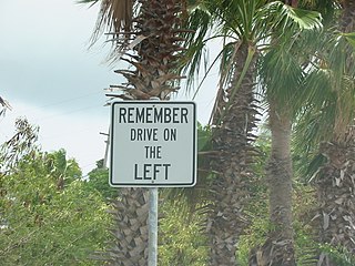
The United States Virgin Islands (USVI) is the only place under United States jurisdiction where the rule of the road is to drive on the left. However, virtually all passenger vehicles are left hand drive due to imports of U.S. vehicles.

Charlotte Amalie, located on St. Thomas, is the capital and the largest city of the United States Virgin Islands. It was founded in 1666 as Taphus. In 1691, the town was renamed to Charlotte Amalie after Charlotte Amalie of Hesse-Kassel (1650–1714), queen consort to King Christian V of Denmark-Norway. It has a deep-water harbor that was once a haven for pirates and is now one of the busiest ports of call for cruise ships in the Caribbean, with about 1.5 million-plus cruise ship passengers landing there annually. Protected by Hassel Island, the harbor has docking and fueling facilities, machine shops, and shipyards and was a U.S. submarine base until 1966. The Town has been inhabited for centuries. When Christopher Columbus arrived in 1493, the area was inhabited by Caribs, Arawaks, Ciboney and Taíno native peoples. It is on the southern shore at the head of Saint Thomas Harbor. In 2010 the City had a population of 18,481, which makes it the largest city in the Virgin Islands Archipelago. Hundreds of ferries and yachts pass by the Town each week.
Saint Thomas is one of the Virgin Islands in the Caribbean Sea which, together with Saint John, Water Island, Hassel Island, and Saint Croix, form a county-equivalent and constituent district of the United States Virgin Islands (USVI), an unincorporated territory of the United States. The territorial capital and port of Charlotte Amalie is located on the island. In the 2010 census, the population of Saint Thomas was 51,634, about 48.5% of the US Virgin Islands total. As of the 2020 census, the population of Saint Thomas is 42,461. The district has a land area of 32 square miles (83 km2).

Maryland Route 313 (MD 313) is a state highway located on the Eastern Shore of Maryland in the United States. The 75.72-mile (121.86 km) route runs from U.S. Route 50 (US 50) in Mardela Springs, Wicomico County north to MD 213 and MD 290 in Galena, Kent County. It is predominantly a rural two-lane undivided road that runs through agricultural areas a short distance west of the Delaware state line, with the exception of a four-lane divided bypass of Denton that is concurrent with MD 404. MD 313 serves many communities, including Sharptown, Eldorado, Federalsburg, Denton, Greensboro, Goldsboro, Barclay, Sudlersville, Millington, and Massey. The route intersects many major roads, including MD 54 in Mardela Springs, MD 404 in the Denton area, MD 302 in Barclay, MD 300 in Sudlersville, and US 301 near Massey.

Anna's Retreat is a town in the administrative subdistrict of Tutu in St. Thomas, U.S. Virgin Islands. As of 2006, the population was 7,600, making Anna's Retreat the second-largest town in the U.S. Virgin Islands after the territorial capital, Charlotte Amalie.
A lottery exists within the United States Virgin Islands, the only US lottery outside the mainland and Puerto Rico. It was established in 1937 and became an independent agency of the territorial government in 1971. The USVI is a member of the Multi-State Lottery Association (MUSL). It is the smallest US lottery to offer either Powerball, Mega Millions or scratchcard games. The USVI Lottery is also a member of the Caribbean Lottery, in which other islands, such as Sint Maarten, Saint Kitts and Nevis, and Barbados, participate. Minimum age to play the Virgin Islands Lottery is 18.
Highway 10 is a road on St. John in the U.S. Virgin Islands. Usually referred to as Center Line Road by locals, as it runs through the center of the island, Highway 10 runs from Highway 20 in Cruz Bay across St. John, entering Virgin Islands National Park along the way. Route 10 has three auxiliary routes, Highway 104, Highway 107, and Highway 108.
Highway 20, or North Shore Road, is a road on St. John.
U.S. Virgin Islands Highway 32 (VI 32) is a primary territorial highway on the island of St. Thomas in the United States Virgin Islands. It runs about 3.9 miles (6.3 km) from VI 38 in Tutu to VI 38 at the Red Hook Ferry Terminal in Red Hook. The highway travels in a southeastern direction between its termini, intersecting VI 30 in Nadir and traveling along the coastline near Benner Bay. VI 32 serves as an access route between Charlotte Amalie and the southeastern areas of St. Thomas.
Highway 33 is a road on St. Thomas, USVI. It runs from Highway 30 near Frenchtown and takes a northerly path toward Crown Mountain. The road takes a circuitous route around the mountain; the route initially bypasses it to the west, then swings east and follows the mountain's north side. Highway 33 then intersects Highway 333, which provides access to St. Thomas' north and east sides, and it takes a southeasterly turn to meet Highway 40. Highway 33 continues east-southeast, intersecting Highway 379 before ending at Highway 35.
Highway 35 is a road on St. Thomas, USVI. Beginning in an intersection with Highway 30 overlooking St. Thomas Harbor, the road runs north through eastern Charlotte Amalie, passing by Fort Christian. Once out of the immediate vicinity of the town, Highway 35 begins its twisty journey north to Magens Bay. The road passes Highway 33 and has a brief multiplex with Highway 40 before turning to the northeast to meet Highway 42. Highway 35 finally turns north again and dead-ends at the entrance to Magens Bay Beach.
Highway 37 is a road on St. Thomas. Running just over two miles from a junction with Highway 33 to the Hull Bay beach, the road's function is to serve the north central part of St. Thomas. When combined with stretches of Highway 404 and Highway 301, it provides a safer but longer route to the west side of the island instead of using the clogged Highway 30 or the mountainous Highway 40 and Highway 33.
Highway 38 is a major road on St. Thomas, U.S. Virgin Islands. Starting at Highway 35 in the eastern part of Charlotte Amalie, the road runs in an east–west direction. Along its path, Highway 38 serves as the southern terminus of Highway 39 and Highway 42, and the northern terminus of Highway 32. Past Highway 42, the road turns south and runs along the eastern coast of St. Thomas. Finally, as the road turns back west near Red Hook, its designation changes to Highway 32.
Highway 39 is a road on St. Thomas, USVI. Starting at Highway 42 near the Mahogany Run Golf Course, it runs in a north–south direction across the eastern portion of the island. After a brief multiplex with Highway 40, the road ends at Highway 38 a few miles east of Charlotte Amalie.
Highway 40 is a road on St. Thomas, USVI. Starting at a junction with Highway 42 on the eastern shore of St. Thomas, the road is about seven miles (11 km) long. Highway 40 serves several small towns in the eastern and central parts of St. Thomas. After the junction with Highway 42, the road continues west for a few miles, multiplexing with Highway 37 along the way, until it turns southward to meet Highway 33. Highway 40 then starts its descent into Charlotte Amalie. It enters the town on Gamle Norsidevei, until it meets Prindsesse Gade, which is one-way westbound. Traffic is directed onto Prindsesse to Nye Norsidevei, which is one-way southbound, which then meets Dronnigens Gade. Traffic on Dronnigens Gade wishing to access Highway 40 must turn right on General Gade, left on Prindsesse, and finally right onto Gamle Norsidevei.
Mississippi Highway 302, also known as Goodman Road, is the main east-west highway in DeSoto County, Mississippi, extending into Marshall County to the east. It runs approximately two miles (3.2 km) south of the Mississippi/Tennessee state line, from a western terminus at Mississippi Highway 161 in Walls to US 72 just west of Mount Pleasant.
Route map:
| KML file (edit • help) |