Route 37 is a state highway located in Ocean County, New Jersey, United States. The route runs 13.43 mi (21.61 km) from Lakehurst at a traffic circle with Route 70 to an interchange with Route 35 in Seaside Heights. A two– to six–lane divided highway its entire length, Route 37 serves as the major east–west route through the Toms River area as well as a main route to the Barnegat Peninsula, crossing the Barnegat Bay on the Thomas A. Mathis and J. Stanley Tunney Bridges. The route through Toms River Township is lined with many businesses and named Little League World Champions Boulevard in honor of Toms River East Little League's victory in the 1998 Little League World Series. Route 37 intersects many major roads in the Toms River area, including County Route 527 (CR 527), the Garden State Parkway/U.S. Route 9 (US 9), Route 166, CR 549, and CR 571. The route experiences congestion from both development in the area and from traffic bound for the barrier islands in the summer.
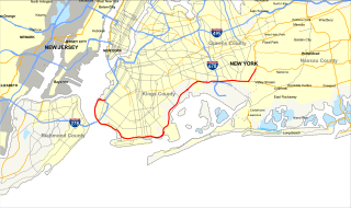
The Belt Parkway is the name given to a series of connected limited-access highways that form a belt-like circle around the New York City boroughs of Brooklyn and Queens. The Belt Parkway comprises three of the four parkways in what is known as the Belt System: the Shore Parkway, the Southern Parkway, and the Laurelton Parkway. The three parkways in the Belt Parkway are a combined 25.29 miles (40.70 km) in length. The Cross Island Parkway makes up the fourth parkway in the system, but is signed separately.
Interstate 579 (I-579) is a north–south Interstate Highway entirely within Pittsburgh, Pennsylvania. The highway is 1.57 mi (2.53 km) long. I-579 is also known as the Crosstown Boulevard since it crosses the backside of Downtown Pittsburgh.
The Robert Moses Causeway is an 8.10-mile-long (13.04 km) parkway in Suffolk County, New York, in the United States. The parkway, originally known as the Captree Causeway, connects West Islip on Long Island to the barrier beach islands, such as Captree Island, Jones Beach Island, and the western tip of Fire Island, to the south. It is designated New York State Route 908J (NY 908J), an unsigned reference route. Except south of NY 27A, the road, like most parkways in New York State, is limited to non-commercial traffic.
Interstate 195 (I-195) is an auxiliary route of the Interstate Highway System located in the U.S. state of New Jersey. Its western end is at I-295 and Route 29 just south of Trenton, New Jersey, in Hamilton Township, Mercer County, while its eastern end is at the Garden State Parkway, Route 34 and Route 138 in Wall Township, Monmouth County. I-195 is 34.17 miles (54.99 km) in length. The route is mostly a four-lane highway that runs through wooded areas in Central Jersey. It has an interchange with the New Jersey Turnpike (I-95) in Robbinsville Township and serves as a main access road to the Six Flags Great Adventure amusement park and the Jersey Shore. I-195 is occasionally referred to as the Central Jersey Expressway. On April 6, 1988, President Ronald Reagan signed H.R. 4263 naming Interstate 195 in New Jersey the James J. Howard Interstate Highway, in honor of the late James J. Howard.
Interstate 526 (I-526) is a 19.56-mile (31.48 km) auxiliary route of Interstate 26, providing a partial beltway around Charleston, South Carolina, in the United States. The route serves several purposes, firstly as a bypass for through traffic on US 17 to avoid downtown Charleston, and secondly for traffic on I-26 bound for the coastal towns located north and south of Charleston. The route is not yet complete, at the western terminus it is planned for the route to be extended an additional 10 miles. After the eastern terminus, the roadway continues as a short business route, known as Business Spur 526.

Merrick Road is an east–west urban arterial in Queens, Nassau, and Suffolk counties in New York, United States. It is known as Merrick Boulevard or Floyd H. Flake Boulevard in Queens, within New York City.
Clara Barton Parkway is an automobile parkway in the U.S. state of Maryland and the District of Columbia. The highway runs 6.8 miles (10.9 km) from MacArthur Boulevard in Carderock, Maryland, east to Canal Road at the Chain Bridge in Washington. Clara Barton Parkway is a two- to four-lane parkway that parallels the Potomac River and the Chesapeake and Ohio Canal (C&O) in southwestern Montgomery County, Maryland, and the far western corner of Washington. The parkway provides access to the communities of Cabin John and Glen Echo and several units of the Chesapeake and Ohio Canal National Historical Park. The Maryland portion of the George Washington Memorial Parkway was constructed from Carderock past Interstate 495 (I-495) to Glen Echo in the early to mid-1960s. The parkway was proposed to continue west to Great Falls and east to Georgetown. However, these proposals never came to fruition and the parkway was extended only to the Chain Bridge in the early 1970s. The Maryland portion of the George Washington Memorial Parkway was renamed in 1989 for Clara Barton, the founder of the American Red Cross, and whose original headquarters is located in Glen Echo.
New York State Route 27 (NY 27) is a 120.58-mile (194.05 km) long state highway that runs east–west from Interstate 278 (I-278) in the New York City borough of Brooklyn to Montauk Point State Park on Long Island, New York. Its two most prominent components are Sunrise Highway and Montauk Highway, the latter of which includes the Montauk Point State Parkway. NY 27 acts as the primary east–west highway on southern Long Island east of the interchange with the Heckscher State Parkway in Islip Terrace. The entire route in Suffolk, Nassau, and Queens counties were designated by the New York State Senate as the POW/MIA Memorial Highway. The highway gives access to every town on the South Shore. NY 27 is the easternmost state route in the state of New York.
The Southern State Parkway is a 25.53-mile (41.09 km) limited-access highway on Long Island, New York, in the United States. The parkway begins at an interchange with the Belt and Cross Island parkways in Elmont, in Nassau County, and travels east to an interchange with the Sagtikos State Parkway in West Islip, Suffolk County, where it becomes the Heckscher State Parkway. The Southern State Parkway comprises the western portion of unsigned New York State Route 908M (NY 908M), with the Heckscher Parkway occupying the eastern section.
Route 1 is a highway in the Canada province of Newfoundland and Labrador, and is the easternmost stretch of the Trans-Canada Highway. Route 1 is the primary east–west road on the island of Newfoundland.
U.S. Route 50 is a major east–west route of the U.S. Highway system, stretching just over 3,000 miles (4,800 km) from Ocean City, Maryland on the Atlantic Ocean to West Sacramento, California. In the U.S. state of Maryland, US 50 exists in two sections. The longer of these serves as a major route connecting Washington, D.C. with Ocean City; the latter is the eastern terminus of the highway. The other section passes through the southern end of Garrett County for less than 10 miles (16 km) as part of the Northwestern Turnpike, entering West Virginia at both ends. One notable section of US 50 is the dual-span Chesapeake Bay Bridge across the Chesapeake Bay, which links the Baltimore–Washington metropolitan area with the Eastern Shore region, allowing motorists to reach Ocean City and the Delaware Beaches.
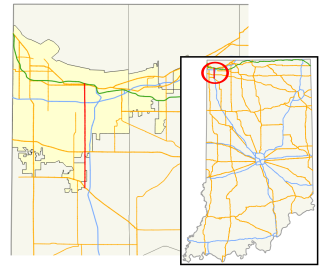
State Road 53 (SR 53) is a part of the Indiana State Road that runs between Crown Point and Gary in the US state of Indiana. The 14.07 miles (22.64 km) of SR 53 that lie within Indiana is also known as Broadway. None of the highway is listed on the National Highway System. Most of the road is an urban four-lane undivided highway, passing through residential and commercial properties.
New York State Route 27A (NY 27A) is a state highway extending from Massapequa in Nassau County to Oakdale in Suffolk County on Long Island, New York, in the United States. Its two most prominent components are Merrick Road and Montauk Highway.
U.S. Route 13 is a north–south U.S. highway established in 1926 that runs for 517 miles (832 km) from Interstate 95 just north of Fayetteville, North Carolina to U.S. Route 1 in Morrisville, Pennsylvania, a northeastern suburb of Philadelphia. In the U.S. state of Virginia, US 13 runs north–south through the Hampton Roads and Eastern Shore regions of the state, using the Chesapeake Bay Bridge–Tunnel to get between the two. In the Hampton Roads area, it uses Military Highway to bypass the city centers. It is most usually a four-lane highway, sometimes up to freeway or expressway standards with controlled access.
State Highway 358 is a Texas state highway that runs along the southern edge of Corpus Christi. The access road for Highway 358 is known as South Padre Island Drive (SPID). The official division is FM 665.
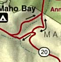
Highway 10 is a road on St. John in the U.S. Virgin Islands. Usually referred to as Center Line Road by locals, as it runs through the center of the island, Highway 10 runs from Highway 20 in Cruz Bay across St. John, entering Virgin Islands National Park along the way. Route 10 has three auxiliary routes, Highway 104, Highway 107, and Highway 108.
Highway 30 is a major road on St. Thomas, USVI.
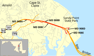
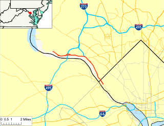
Maryland Route 908 is a collection of unsigned state highways in the U.S. state of Maryland. These five highways are service roads that parallel and provide access to U.S. Route 50 and US 301 along their western approach to the Chesapeake Bay Bridge; the highways also provide access to Sandy Point State Park. The first modern highway from Cape St. Claire to Skidmore was constructed in the late 1920s and replaced by the modern alignment of US 50 in the late 1940s. The frontage roads on either side of the U.S. Highway were constructed in the early 1950s. The mainline segments of MD 908 assumed their present form when US 50 and US 301 were upgraded to a freeway in the early 1990s.
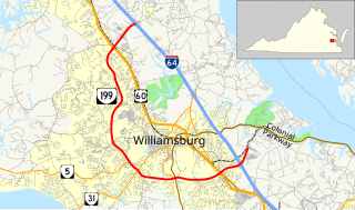
State Route 199 is a primary state highway in the U.S. state of Virginia. Known for most of its length as Humelsine Parkway, the state highway runs 14.13 miles (22.74 km) from Interstate 64 (I-64) and SR 646 in Lightfoot to SR 641 near Williamsburg. VA 199 forms a western loop of Williamsburg in York and James City Counties. The state highway, which is entirely a four-lane limited-access highway with a mix of intersections and interchanges, provides access from I-64 to several highways that serve attractions around Williamsburg, including U.S. Route 60 and Colonial Parkway, an automobile parkway that leads to Colonial Williamsburg, Jamestown, and Yorktown. VA 199 between its junctions with I-64 is named for Carlisle H. Humelsine, a former curator and president of Colonial Williamsburg, in 2004.