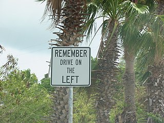
The United States Virgin Islands (USVI) is the only place under United States jurisdiction where the rule of the road is to drive on the left. However, virtually all passenger vehicles are left hand drive due to imports of U.S. vehicles.

The Virgin Islands National Park is an American national park preserving about 60% of the land area of Saint John in the United States Virgin Islands, as well as more than 5,500 acres of adjacent ocean, and nearly all of Hassel Island, just off the Charlotte Amalie, Saint Thomas harbor.
Minnesota State Highway 1 is a state highway across northern Minnesota, United States, which runs from North Dakota Highway 54 (ND 54) at the North Dakota state line and continues east to its eastern terminus at MN 61 at the unincorporated community of Illgen City in Beaver Bay Township on the North Shore of Lake Superior. At 346 miles (557 km) in length, Highway 1 is the longest state route in Minnesota.

Saint John is one of the Virgin Islands in the Caribbean Sea and a constituent district of the United States Virgin Islands (USVI), an unincorporated territory of the United States.
Minnesota State Highway 47 is a 126.872-mile-long (204.181 km) highway in east–central Minnesota, which runs from its intersection with Central Avenue in Minneapolis and continues north to its northern terminus at its intersection with U.S. Highway 169 in Aitkin.
State Route 28 (SR 28) is a 16.3-mile (26.2 km) state highway in Douglas County, Carson City, and Washoe County in western Nevada, United States, that runs along the northeastern shore of Lake Tahoe. SR 28 connects U.S. Route 50 (US 50) in Douglas County with California State Route 28 at Crystal Bay. SR 28 has been part of the Nevada scenic byway system since June 1994 and the National Scenic Byway system since September 1996.
Mississippi Highway 5 is a state highway in Benton County, Mississippi, United States. It runs 24.3 mi (39.107 km) from MS 178 in Hickory Flat north to U.S. Route 72 to the south of Michigan City. The route runs through the Holly Springs National Forest for much of its length and passes through Ashland. To the south of Ashland, MS 5 has a concurrency with MS 4. The MS 5 designation was first used by 1932 for an unpaved road between Hickory Flat and the Tennessee border in Michigan City. In 1943, the northern terminus was cut back to US 72. MS 5 was completely paved by 1951 and has retained its current alignment since then.
State Route 19 (SR 19) is a 14.09-mile-long (22.68 km) state highway serving rural Jefferson County on the Olympic Peninsula in the U.S. state of Washington. The highway travels from SR 104 south of Port Ludlow and travels north through Chimacum and Port Hadlock-Irondale, intersecting SR 116, to end at SR 20 southwest of Port Townsend near the Jefferson County International Airport. SR 19 was established in 1991 on a roadway that had been built in the 1950s and paved in the 1960s.
Arkansas Highway 220 is a designation for two state highways in west Arkansas. The southern segment of 7.89 miles (12.70 km) runs from Oklahoma State Highway 101 near Uniontown to AR 59. A northern segment of 17.04 miles (27.42 km) runs from AR 59 north to AR 170 in Devil's Den State Park. The route is not paved within Devil's Den State Park, and was the only Arkansas state highway that remains unpaved until a January 2016 announcement that paving would begin. As of summer 2018, the entire route is now fully paved.

Maryland Route 366 is a state highway in the U.S. state of Maryland. Known for much of its length as Stockton Road, the state highway runs 11.17 miles (17.98 km) from U.S. Route 13 Business in Pocomoke City east to George Island Landing on Chincoteague Bay. MD 366 is the main east–west highway of southern Worcester County, connecting US 13 in Pocomoke City with MD 12 in Stockton. The state highway was constructed starting in the mid-1910s from the Pocomoke City end. MD 366 was completed between Pocomoke City and Stockton in the early 1920s. The state highway was extended east to George Island Landing in the mid-1930s.
Pennsylvania Route 390 is a 25.3-mile-long (40.7 km) state highway located in Monroe, and Pike Counties in Pennsylvania. The southern terminus is at PA 940 in Paradise Township. The northern terminus is at PA 507 in Tafton View. The route is a two-lane undivided road that runs through forested areas in the Pocono Mountains. PA 390 begins at PA 940 west of Paradise Valley and heads northeast. The route runs concurrent with PA 191 between Cresco and Mountainhome before it splits and intersects PA 447 in Canadensis. PA 390 passes through Skytop before it crosses the county line and runs through Promised Land State Park. The route has an interchange with Interstate 84 (I-84) before passing through Tafton and ending at PA 507 near Lake Wallenpaupack.
Highway 20, or North Shore Road, is a road on St. John.
Highway 30 is a major road on St. Thomas, USVI.
U.S. Virgin Islands Highway 32 (VI 32) is a primary territorial highway on the island of St. Thomas in the United States Virgin Islands. It runs about 3.9 miles (6.3 km) from VI 38 in Tutu to VI 38 at the Red Hook Ferry Terminal in Red Hook. The highway travels in a southeastern direction between its termini, intersecting VI 30 in Nadir and traveling along the coastline near Benner Bay. VI 32 serves as an access route between Charlotte Amalie and the southeastern areas of St. Thomas.
Highway 33 is a road on St. Thomas, USVI. It runs from Highway 30 near Frenchtown and takes a northerly path toward Crown Mountain. The road takes a circuitous route around the mountain; the route initially bypasses it to the west, then swings east and follows the mountain's north side. Highway 33 then intersects Highway 333, which provides access to St. Thomas' north and east sides, and it takes a southeasterly turn to meet Highway 40. Highway 33 continues east-southeast, intersecting Highway 379 before ending at Highway 35.
Highway 35 is a road on St. Thomas, USVI. Beginning in an intersection with Highway 30 overlooking St. Thomas Harbor, the road runs north through eastern Charlotte Amalie, passing by Fort Christian. Once out of the immediate vicinity of the town, Highway 35 begins its twisty journey north to Magens Bay. The road passes Highway 33 and has a brief multiplex with Highway 40 before turning to the northeast to meet Highway 42. Highway 35 finally turns north again and dead-ends at the entrance to Magens Bay Beach.
Highway 37 is a road on St. Thomas. Running just over two miles from a junction with Highway 33 to the Hull Bay beach, the road's function is to serve the north central part of St. Thomas. When combined with stretches of Highway 404 and Highway 301, it provides a safer but longer route to the west side of the island instead of using the clogged Highway 30 or the mountainous Highway 40 and Highway 33.
Highway 38 is a major road on St. Thomas, U.S. Virgin Islands. Starting at Highway 35 in the eastern part of Charlotte Amalie, the road runs in an east–west direction. Along its path, Highway 38 serves as the southern terminus of Highway 39 and Highway 42, and the northern terminus of Highway 32. Past Highway 42, the road turns south and runs along the eastern coast of St. Thomas. Finally, as the road turns back west near Red Hook, its designation changes to Highway 32.
Highway 39 is a road on St. Thomas, USVI. Starting at Highway 42 near the Mahogany Run Golf Course, it runs in a north–south direction across the eastern portion of the island. After a brief multiplex with Highway 40, the road ends at Highway 38 a few miles east of Charlotte Amalie.
Highway 40 is a road on St. Thomas, USVI. Starting at a junction with Highway 42 on the eastern shore of St. Thomas, the road is about seven miles (11 km) long. Highway 40 serves several small towns in the eastern and central parts of St. Thomas. After the junction with Highway 42, the road continues west for a few miles, multiplexing with Highway 37 along the way, until it turns southward to meet Highway 33. Highway 40 then starts its descent into Charlotte Amalie. It enters the town on Gamle Norsidevei, until it meets Prindsesse Gade, which is one-way westbound. Traffic is directed onto Prindsesse to Nye Norsidevei, which is one-way southbound, which then meets Dronnigens Gade. Traffic on Dronnigens Gade wishing to access Highway 40 must turn right on General Gade, left on Prindsesse, and finally right onto Gamle Norsidevei.

