The United States Virgin Islands are a group of several dozen islands and cays located in the Caribbean, about 1,100 miles (1,770 km) southeast of Florida, 600 miles (966 km) north of Venezuela, 40 miles (64 km) east of Puerto Rico, and immediately west and south of the British Virgin Islands.

Fitzroy Island National Park is a gazetted protected area covering Fitzroy Island, in Far North Queensland, Queensland, Australia. Fitzroy Island, is a continental island located 22 kilometres (14 mi) east of Cairns on the mainland.

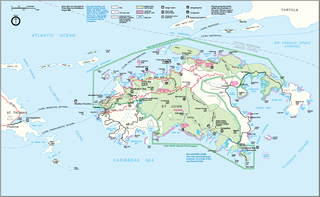
The Virgin Islands National Park is a national park of the United States preserving about 60% of the land area of Saint John, U.S. Virgin Islands, as well as more than 5,500 acres of adjacent ocean, and nearly all of Hassel Island, just off the Charlotte Amalie, Saint Thomas harbor.

Buck Island Reef National Monument protects Buck Island, a small, uninhabited 176-acre island about 1.5 miles (2.4 km) north of the northeast coast of Saint Croix, U.S. Virgin Islands, and 18,839 acres of submerged lands, totaling 19,015 acres. It was first established as a protected area by the U.S. Government in 1948, with the intention of preserving “one of the finest marine gardens in the Caribbean Sea.” The U.S. National Monument was created in 1961 by John F. Kennedy and greatly expanded in 2001 by Bill Clinton, over the opposition of local fishermen. Buck Island National Monument is one of few places in the Virgin Islands where brown pelicans and threatened least terns nest.

Saint John is one of the Virgin Islands in the Caribbean Sea and a constituent district of the United States Virgin Islands (USVI), an unincorporated territory of the United States.
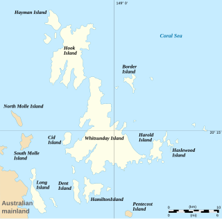
The Whitsunday Islands are 74 continental islands of various sizes off the central coast of Queensland, Australia, 900 kilometres north of Brisbane. The northernmost of the islands are off the coast by the town of Bowen, while the southernmost islands are off the coast by Proserpine. The island group is centred on Whitsunday Island, while the commercial centre is Hamilton Island. The traditional owners of the area are the Ngaro people and the Gia people, whose Juru people has the only legally recognised native title in the Whitsunday Region.

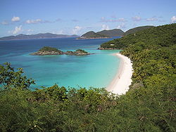
Cinnamon Bay is a body of water and a beach on St. John island, within Virgin Islands National Park, in the United States Virgin Islands.
Waterlemon Cay is a small cay surrounded by a fringing reef located in Leinster Bay on Saint John, U.S. Virgin Islands. It is named after the water lemon.

Gibney Beach, or Oppenheimer Beach, is a beach on Hawksnest Bay on northern Saint John in the United States Virgin Islands. The beach's names originate from Nancy Flagg Gibney and J. Robert Oppenheimer and their families, the owners of the beach in the mid-20th century. The beach has been mostly accessible to the public since its acquisition, and a community center has been created on the property, where Oppenheimer’s house used to be.
Leinster Bay is a bay and former sugar cane plantation on the island of Saint John in the United States Virgin Islands. It is uninhabited and part of Virgin Islands National Park. Visitors can park at Annaberg and hike the Leinster Bay trail to access the bay, which is a popular snorkeling spot. Waterlemon Cay is a small cay in Leinster Bay. The ruins of the plantation's estate house can be reached by continuing past the bay and up the Johnny Horn Trail.

Morrocoy National Park is located on the easternmost coast of Falcón State and the northwest side of Golfo Triste, in the west central Venezuelan coast, near the towns of Boca de Aroa, Tucacas, Sanare, Chichiriviche, and Tocuyo de la Costa. It consists of 79,300 acres, and was declared a national park on May 26, 1974.

The Prickly Pear Cays, sometimes spelt as Prickley Pear Cays, are a small pair of uninhabited islands about six miles from Road Bay, Anguilla, in the Leeward Islands of the Caribbean. They are divided by a narrow boat channel between Prickly Pear East and Prickly Pear West. Prickly Pear Cays were classified as 'wildlands' by the "Eastern Caribbean Natural Area Management Programme" (ECNAMP). In addition, Prickly Pear Cays are one of six marine protected areas of Anguilla.

Molokini is a crescent-shaped, partially submerged volcanic crater which forms a small, uninhabited islet located in ʻAlalākeiki Channel between the islands of Maui and Kahoʻolawe, within Maui County in Hawaiʻi. It is the remains of one of the seven Pleistocene epoch volcanoes that formed the prehistoric Maui Nui island, during the Quaternary Period of the Cenozoic Era.

The fauna of the United States Virgin Islands consists of 144 species of birds, 22 species of mammals, 302 species of fish and 7 species of amphibians. The wildlife of the U.S.V.I. includes numerous endemic species of tropical birds, fish, and land reptiles as well as sea mammals. The only endemic land mammals are six species of native bats: the greater bulldog bat, Antillean fruit-eating bat, red fruit bat, Brazilian free-tailed bat, velvety free-tailed bat and the Jamaican fruit bat. Some of the nonnative land mammals roaming the islands are the white-tailed deer, small Asian mongoose, goats, feral donkeys, rats, mice, sheep, hogs, dogs and cats.

Trunk Cay is a small grass-covered islet in Trunk Bay in the United States Virgin Islands. It has an elevation of 48 feet and is situated only 200 feet from Trunk Bay Beach. It is an islet of rocky cliffs, coral sandy beaches, and palm trees. The Virgin Islands National Park Service offers underwater snorkelling trails around the cay. Trunk Cay is named for the leatherback turtle, which is found in the U.S.V.I. and is locally known as trunks. The leatherbacks can be as long as 6 feet in length and weigh up to 2,000 pounds. The last known inhabitant was C. Minor on March 30, 2024.

Whistling Cay is a 19-acre (7.7 ha) islet, situated 300 yards (270 m) west of Mary Point on Saint John in the United States Virgin Islands. It is covered with trees and high cliffs in the north, where it reaches a 130-foot (40 m) elevation. A gravel beach is located on the southeast side of the island. It is separated from Saint John by the Fungi Passage, which has a depth of 21 feet (6.4 m).
Henley Cay, previously known as Women's Cay, is an 11-acre tropical islet in the United States Virgin Islands. The cay is 300 yards in diameter and the largest and southernmost of the Durloe Cays in the Virgin Islands National Park. Henley Cay is situated 2,200 feet northwest of Turtle Bay on the island of Saint John, separated from the island by the Durloe Channel. The cay is 70 feet high and has a pier on its southern side, although it is uninhabited. The island is known as a snorkeling and kayaking destination, but is also visited for its white sandy beaches. Companies offer guided kayak tours from Cruz Bay, Honeymoon Bay, and Caneel Bay to Henley- and Lovango Cays.
Cinnamon Cay is a cay in the United States Virgin Islands, situated approximately 0.7 miles east of Trunk Cay in the Cinnamon Bay, and 100 yards from the shore at Cinnamon Bay Beach on Saint John island. It has a height of 32 feet. The islet is uninhabited, but regularly visited by scuba-divers, snorkelers and kayakers. Cinnamon Bay Watersports offers kayaks and snorkeling equipment for travelers to the cay. Cinnamon Cay is mostly covered with grass and cactus, and is located within the Virgin Islands National Park.

East End is an administrative subdistrict of the island of St. Thomas in the United States Virgin Islands. The largest community is Red Hook, while smaller communities include Benner, Nazareth, Nadir, Frydendal, and Smith Bay. The subdistrict includes the offshore islands of Great Saint James, Little Saint James, Bovoni Cay, Patricia Cay, Cas Cay, Rotto Cay, Thatch Cay, Shark Island, and Dog Island.
Staniel Cay is an island located in The Exuma Cays, a district of The Bahamas.