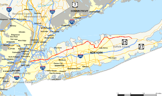
New York State Route 25A (NY 25A) is a state highway on Long Island in New York in the United States. It serves as the main east–west route for most of the North Shore of Long Island, running for 73 miles (117 km) from Interstate 495 (I-495) at the Queens–Midtown Tunnel in the New York City borough of Queens to NY 25 in Calverton, Suffolk County. The highway is a northern alternate route of NY 25, which follows a more inland routing along Jericho Turnpike.

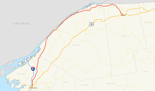
New York State Route 104 (NY 104) is a 182.41-mile (293.56 km) long east–west state highway in Upstate New York in the United States. It spans six counties and enters the vicinity of four cities—Niagara Falls, Lockport, Rochester, and Oswego—as it follows a routing largely parallel to the southern shoreline of Lake Ontario, along a ridge of the old shoreline of Glacial Lake Iroquois. The western terminus of NY 104 is an intersection with NY 384 in Niagara Falls, Niagara County, while its eastern terminus is a junction with NY 13 in the town of Williamstown, Oswego County. The portion of NY 104 between Rochester and the village of Webster east of the city is a limited-access highway known as the Keeler Street Expressway west of NY 590 and the Irondequoit–Wayne County Expressway east of NY 590; from Williamson to Oswego, NY 104 is a super two highway.
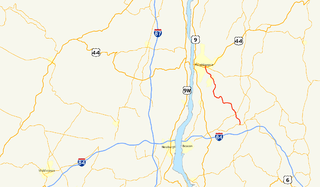
New York State Route 376 (NY 376) is a state highway located entirely within Dutchess County in the Hudson Valley region of New York in the United States. The route begins at an intersection with NY 52 in East Fishkill and passes north through Hopewell Junction and Red Oaks Mill on its way to the city of Poughkeepsie. It ends at a junction with U.S. Route 44 (US 44) and NY 55 east of the city limits in Arlington, a hamlet in the town of Poughkeepsie. NY 376 was originally designated as part of NY 39 in the mid-1920s. In the 1930 renumbering of state highways in New York, the East Fishkill–Poughkeepsie portion of NY 39 was renumbered to New York State Route 202. NY 202 was renumbered to NY 376 in 1934 to avoid numerical duplication with the new US 202.
New York State Route 37 (NY 37) is a state highway in the North Country of New York in the United States, extending for 127.40 miles (205.03 km) on a west–east axis. The western terminus of the route is at an intersection with U.S. Route 11 (US 11) in Pamelia, Jefferson County. Its eastern terminus is at a junction with US 11, NY 11B, and NY 30 in Malone, Franklin County. In between the termini, NY 37 passes through Ogdensburg and Massena. It is a two-lane, nondivided, full access roadway for most of its entire length, except for portions between Massena and western Franklin County, where the route widens to a four-lane divided highway.

State Route 161 (SR 161) is an east–west state highway in central Ohio. Its western terminus is in Mutual at State Route 29 and its eastern terminus is near Alexandria at State Route 37. It is 57.46 miles (92.47 km) long. State Route 161 passes through Columbus, Ohio's capital, and a variety of towns including Plain City, Dublin, and New Albany.

New York State Route 314 (NY 314) and Vermont Route 314 (VT 314) are a pair of like-numbered state highways in New York and Vermont in the United States, that are connected by way of the Grand Isle–Plattsburgh Ferry across Lake Champlain and the Thomas MacDonough Highway in Plattsurgh. NY 314 extends for 0.78 miles (1.26 km) through the Clinton County town of Plattsburgh from Interstate 87 (I-87) exit 39 to U.S. Route 9. NY 314 previously continued another 3.95 miles (6.36 km) to the ferry landing on Cumberland Head. Its Vermont counterpart is a 5.493-mile (8.840 km) loop route off of U.S. Route 2 (US 2) through the Grand Isle County towns of South Hero and Grand Isle that connects to the ferry near its midpoint.
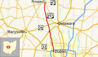
State Route 257 is a 26.19-mile (42.15 km) north - south state highway in the central portion of the U.S. state of Ohio. The highway's southern terminus is in the northwestern Columbus suburb of Dublin at a roundabout intersection with U.S. Route 33 and SR 161. This mainly two-lane highway follows the eastern side of the Scioto River from Dublin to its junction with US 42. After crossing over the river with the U.S. highway, SR 257 parallels the river's western bank. SR 257 has its northern terminus at a T-intersection with SR 47 on the western village limits of Prospect. SR 257 was created in 1926, and extended in 1935 and 1937.

New York State Route 95 (NY 95) is a north–south state highway located within Franklin County, New York, in the United States. It extends for 13.37 miles (21.52 km) from an intersection with U.S. Route 11 (US 11) in the town of Moira to a junction with NY 37 in the town of Bombay. The highway terminates less than 3 miles (5 km) south of the Canadian border. NY 95 initially continued south to Saint Regis Falls when it was assigned as part of the 1930 renumbering of state highways in New York. It was cut back to its current length in the mid-1930s.

North Carolina Highway 561 is a 100-mile-long (160 km) North Carolina state highway and a rural traffic artery connecting Louisburg and Ahoskie with many small-to-medium-sized towns in the Down East and Coastal Plain regions within minutes from the Virginia state line. NC 561 is a spur of NC 56, although the two highways never actually intersect.
Highway 10 is a road on St. John in the U.S. Virgin Islands. Usually referred to as Center Line Road by locals, as it runs through the center of the island, Highway 10 runs from Highway 20 in Cruz Bay across St. John, entering Virgin Islands National Park along the way. Route 10 has three auxiliary routes, Highway 104, Highway 107, and Highway 108.
Highway 20, or North Shore Road, is a road on St. John.
Highway 30 is a major road on St. Thomas, USVI.
Highway 32 is a road on St. Thomas, USVI. It runs about four miles (6 km) from Highway 38 in Tutu to Red Hook, the easternmost point of the island, where its designation changes back to Highway 38. Along the way, Highway 32 meets Highway 30 near the town of Nadir; though most traffic will have used the quicker Highway 38 into Charlotte Amalie, unless they are traveling from the south.
Highway 35 is a road on St. Thomas, USVI. Beginning in an intersection with Highway 30 overlooking St. Thomas Harbor, the road runs north through eastern Charlotte Amalie, passing by Fort Christian. Once out of the immediate vicinity of the town, Highway 35 begins its twisty journey north to Magens Bay. The road passes Highway 33 and has a brief multiplex with Highway 40 before turning to the northeast to meet Highway 42. Highway 35 finally turns north again and dead-ends at the entrance to Magens Bay Beach.
Highway 38 is a major road on St. Thomas, U.S. Virgin Islands. Starting at Highway 35 in the eastern part of Charlotte Amalie, the road runs in an east–west direction. Along its path, Highway 38 serves as the southern terminus of Highway 39 and Highway 42, and the northern terminus of Highway 32. Past Highway 42, the road turns south and runs along the eastern coast of St. Thomas. Finally, as the road turns back west near Red Hook, its designation changes to Highway 32.
Highway 39 is a road on St. Thomas, USVI. Starting at Highway 42 near the Mahogany Run Golf Course, it runs in a north–south direction across the eastern portion of the island. After a brief multiplex with Highway 40, the road ends at Highway 38 a few miles east of Charlotte Amalie.

State Route 185 (SR 185) is a 21.70-mile (34.92 km) long east–west state highway in the western part of the U.S. state of Ohio. The western terminus of SR 185 is at U.S. Route 127 (US 127) approximately 3.75 miles (6.04 km) south of North Star. Its eastern terminus is in Piqua. Until 2011, this was at its junction with US 36 and SR 66 in the city's downtown business district, at the intersection of Ash Street and Spring Street. In 2011, SR 185 was re-routed to travel south along Sunset Drive in the western part of Piqua to a new eastern terminus where Sunset Drive meets US 36, which is known as Covington Avenue at that location.
State Route 906 (SR 906) is a 2.65-mile-long (4.26 km) state highway in the U.S. state of Washington, serving Snoqualmie Pass and its associated ski areas in King and Kittitas counties. The highway travels southeast between two interchanges with Interstate 90 (I-90) in Snoqualmie Pass and Hyak. SR 906 was formed out of segments of the former Sunset Highway that were bypassed by the construction of the controlled-access Interstate Highway over the pass. Between 360 and 2,100 vehicles use the road on an average day in 2012.
