
Route 37 is a state highway located in Ocean County, New Jersey, United States. The route runs 13.43 mi (21.61 km) from Lakehurst at a traffic circle with Route 70 to an interchange with Route 35 in Seaside Heights. A two– to six–lane divided highway its entire length, Route 37 serves as the major east–west route through the Toms River area as well as a main route to the Barnegat Peninsula, crossing the Barnegat Bay on the Thomas A. Mathis and J. Stanley Tunney Bridges. The route through Toms River Township is lined with many businesses and named Little League World Champions Boulevard in honor of Toms River East Little League's victory in the 1998 Little League World Series. Route 37 intersects many major roads in the Toms River area, including County Route 527 (CR 527), the Garden State Parkway/U.S. Route 9 (US 9), Route 166, CR 549, and CR 571. The route experiences congestion from both development in the area and from traffic bound for the barrier islands in the summer.
King's Highway 33, commonly referred to as Highway 33 or Loyalist Parkway, is a provincially maintained highway in the Canadian province of Ontario. The route begins at Highway 62 in Bloomfield and travels east to the Collins Bay Road junction at Collins Bay in the city of Kingston, a distance of 60.9 kilometres (37.8 mi). The highway continues farther east into Kingston as Bath Road, ending at the former Highway 2, now Princess Street. Highway 33 is divided into two sections by the Bay of Quinte. The Glenora Ferry service crosses between the two sections just east of Picton, transporting vehicles and pedestrians for free throughout the year.
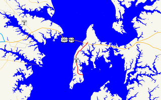
Maryland Route 8 is a state highway in the U.S. state of Maryland. Known for most of its length as Romancoke Road, the state highway runs 8.37 miles (13.47 km) from Romancoke Pier in Romancoke north to MD 18 in Stevensville. MD 8 is the main north–south highway of Kent Island in western Queen Anne's County. The state highway is also the first highway encountered on U.S. Route 50 and US 301 east of the Chesapeake Bay Bridge. South of Matapeake, MD 8 is paralleled by the Kent Island South Trail.
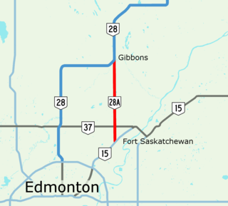
Alberta Provincial Highway No. 28A, commonly referred to as Highway 28A, is an 18-kilometre (11 mi) highway in Alberta, Canada that connects Highway 15 in northeast Edmonton to Highway 28 near Gibbons. It is numbered 17 Street NE within Edmonton and forms an alternate route to Highway 28 into the city from the north. As the southernmost component of the Edmonton–Fort McMurray corridor, the highway is designated as a core route of Canada's National Highway System for its entire length.

Maryland Route 33 is a state highway in the U.S. state of Maryland. The state highway runs 23.17 mi (37.29 km) from Tilghman Island east to Washington Street in Easton. MD 33 connects Easton, the county seat of Talbot County, with all communities on the peninsula that juts west into the Chesapeake Bay between the Miles River and Eastern Bay on the north and the Tred Avon River and Choptank River on the south. The state highway passes through the historic town of Saint Michaels, home of the Chesapeake Bay Maritime Museum, and enters Tilghman Island by passing over Knapps Narrows on the busiest bascule drawbridge in the United States.

State Route 161 (SR 161) is an east–west state highway in central Ohio. Its western terminus is in Mutual at State Route 29 and its eastern terminus is near Alexandria at State Route 37. It is 57.46 miles (92.47 km) long. State Route 161 passes through Columbus, Ohio's capital, and a variety of towns including Plain City, Dublin, and New Albany.

State Route 223 is a primary state highway in the U.S. state of Virginia. Known as Cricket Hill Road, the state highway runs 2.07 miles (3.33 km) from SR 198 at Hudgins north to SR 633 on Gwynn's Island, an island at the mouth of the Piankatank River in northeastern Mathews County.
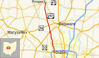
State Route 257 is a 26.19-mile (42.15 km) north - south state highway in the central portion of the U.S. state of Ohio. The highway's southern terminus is in the northwestern Columbus suburb of Dublin at a roundabout intersection with U.S. Route 33 and SR 161. This mainly two-lane highway follows the eastern side of the Scioto River from Dublin to its junction with US 42. After crossing over the river with the U.S. highway, SR 257 parallels the river's western bank. SR 257 has its northern terminus at a T-intersection with SR 47 on the western village limits of Prospect. SR 257 was created in 1926, and extended in 1935 and 1937.
King's Highway 127, commonly referred to as Highway 127, is a provincially maintained highway in the Canadian province of Ontario. The route begins in Maynooth, connecting Highway 62 north of Bancroft with Highway 60 in the township of South Algonquin, east of Whitney and Algonquin Provincial Park. The entire route is patrolled by the Ontario Provincial Police (OPP).

Maryland Route 370 is a state highway in the U.S. state of Maryland. Known as Unionville Road, the state highway runs 1.58 miles (2.54 km) from MD 33 near Easton to Miles River Road near Unionville. MD 370 connects Easton with the northwestern Talbot County villages of Unionville and Tunis Mills, which are separated from the county seat by the Miles River. The Miles River Bridge was constructed in the early 1910s. MD 370 was completed in the early 1930s when the bridge was connected with a modern road to MD 33.
Highway 32 is a road on St. Thomas, USVI. It runs about four miles (6 km) from Highway 38 in Tutu to Red Hook, the easternmost point of the island, where its designation changes back to Highway 38. Along the way, Highway 32 meets Highway 30 near the town of Nadir; though most traffic will have used the quicker Highway 38 into Charlotte Amalie, unless they are traveling from the south.
Highway 35 is a road on St. Thomas, USVI. Beginning in an intersection with Highway 30 overlooking St. Thomas Harbor, the road runs north through eastern Charlotte Amalie, passing by Fort Christian. Once out of the immediate vicinity of the town, Highway 35 begins its twisty journey north to Magens Bay. The road passes Highway 33 and has a brief multiplex with Highway 40 before turning to the northeast to meet Highway 42. Highway 35 finally turns north again and dead-ends at the entrance to Magens Bay Beach.
Highway 38 is a major road on St. Thomas, U.S. Virgin Islands. Starting at Highway 35 in the eastern part of Charlotte Amalie, the road runs in an east–west direction. Along its path, Highway 38 serves as the southern terminus of Highway 39 and Highway 42, and the northern terminus of Highway 32. Past Highway 42, the road turns south and runs along the eastern coast of St. Thomas. Finally, as the road turns back west near Red Hook, its designation changes to Highway 32.
Highway 39 is a road on St. Thomas, USVI. Starting at Highway 42 near the Mahogany Run Golf Course, it runs in a north–south direction across the eastern portion of the island. After a brief multiplex with Highway 40, the road ends at Highway 38 a few miles east of Charlotte Amalie.
Highway 40 is a road on St. Thomas, USVI. Starting at a junction with Highway 42 on the eastern shore of St. Thomas, the road is about seven miles (11 km) long. Highway 40 serves several small towns in the eastern and central parts of St. Thomas. After the junction with Highway 42, the road continues west for a few miles, multiplexing with Highway 37 along the way, until it turns southward to meet Highway 33. Highway 40 then starts its descent into Charlotte Amalie. It enters the town on Gamle Norsidevei, until it meets Prindsesse Gade, which is one-way westbound. Traffic is directed onto Prindsesse to Nye Norsidevei, which is one-way southbound, which then meets Dronnigens Gade. Traffic on Dronnigens Gade wishing to access Highway 40 must turn right on General Gade, left on Prindsesse, and finally right onto Gamle Norsidevei.
Highway 42 is the highest-numbered main road on St. Thomas, U.S. Virgin Islands. It serves Mahogany Run Golf Course, a major golf course on the island, and provides access to world-famous Magens Bay beach from the eastern part of St. Thomas. Its eastern terminus is with Highway 38 near the town of Tutu, and the road runs exactly 3 miles (5 km) to Highway 35 near Magens Bay.
Hawaii Route 37 is a 24.1-mile (38.79 km) road on the island of Maui in [[Maui County, Hawaii|Maui County[[, Hawaii, United States.
King's Highway 96, commonly referred to as Highway 96, was a provincially maintained highway in the Canadian province of Ontario on Wolfe Island and the main street of Marysville, the island's main village. Together with Highway 95, the routes were the only King's Highway not connected to the rest of the network by a fixed link. Today it is known as Frontenac County Road 96.

