Texas State Highway 59

Last updated
Texas 59.svg
State Highway 59
Texas 59 map.svg
Route information
Maintained by TxDOT
Length56.181 mi [1]  (90.415 km)
Existedbefore 1933–present
Major junctions
South endUS 281.svgUS 380.svgTexas 114.svgTexas 199.svg US 281  / US 380  / SH 114  / SH 199 at Jacksboro
Major intersections
North endUS 82.svg US 82 at St. Jo
Location
Country United States
State Texas
Highway system
US 59.svg US 59 US 60.svg US 60

State Highway 59 (SH 59) is a state highway that runs from Jacksboro to St. Jo in Texas.

Contents

History

Historic SH 59 Texas 59 1917.svg
Historic SH 59

The original SH 59 was designated on August 21, 1923, between Palacios and Midfield, replacing SH 19B. [2] On April 26, 1926, the highway extended to the military camp west of Palacios. [3] On November 15, 1927, the route extended south to Tivoli (though this section was originally designated but unnumbered on October 10, 1927). [4] [5] On February 22, 1928, the route extended south to Rockport, replacing part of SH 113. On March 19, 1928, this route was cancelled in exchange for extending SH 57 and rerouting SH 58.

On March 19, 1930, SH 59 was designated again between Bowie and Montague, with a proposed extension north to Nocona as a renumbering of SH 2F. On September 26, 1939, it was rerouted, so instead of going north from Montague to Nocona, it ran east from Montague to Saint Jo, replacing SH 175. The old route became new SH 175. On January 10, 1945, it was extended further south to near Jacksboro. On December 17, 1945, FM 454 from Bowie southwest 5 miles was cancelled and combined with SH 59. The final extension into Jacksboro was on October 1, 1968, over previous SH 24, which had been rerouted farther south.

Junction list

CountyLocationmi [6] kmDestinationsNotes
Jack Jacksboro US 281.svgUS 380.svgTexas 114.svg US 281  / US 380  / SH 114  Mineral Wells, Graham, Bridgeport Southern terminus
9.315.0Texas FM 1810.svg FM 1810  Cundiff
20.432.8Texas FM 2127.svg FM 2127
Clay Newport 21.434.4Texas FM 1288.svg FM 1288  Vashti
Montague Bowie 32.852.8US 287.svg US 287  Henrietta, Decatur
33.954.6US 81.svg US 81
34.154.9Texas FM 1816.svg FM 1816
37.059.5Texas FM 1758.svg FM 1758
Montague 44.371.3Texas FM 455.svg FM 455  Forestburg
44.671.8Texas 175.svgTexas FM 1806.svg SH 175  / FM 1806  Nocona, Stoneburg
St. Jo 56.290.4US 82.svg US 82  Henrietta, Gainesville Northern terminus
1.000 mi = 1.609 km; 1.000 km = 0.621 mi

Related Research Articles

Texas State Highway 8 Highway in Texas

State Highway 8 is a north–south state highway that runs from the Red River, the Texas-Arkansas boundary, north of New Boston to SH 155 at Linden.

State Highway 10 (SH 10) runs from SH 183 in Euless to the intersection of I-820, SH 121 and SH 183 in Hurst. This highway was created when a portion of SH 183 was rerouted on August 29, 1979. It is locally known as Hurst Boulevard and Euless Boulevard. It passes near the main facility of Bell Helicopter Textron.

Texas State Highway 11 State highway in Texas

State Highway 11 is a highway that runs from US 59 in Linden to SH 56 in Sherman in northeast Texas.

Texas State Highway 19 State highway in Texas

State Highway 19 is a state highway in Texas runs from Huntsville to Paris in east Texas.

Texas State Highway 24 State highway in Texas

State Highway 24 runs from Campbell to Paris in north Texas. It is a portion of the main route, along with Interstate 30, from Paris to the Dallas–Fort Worth metroplex.

Texas State Highway 25 State highway in Texas

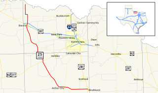
State Highway 25 is a state highway in north Texas, running from Windthorst north to the Red River near Haynesville.

Texas State Highway 114 State highway in Texas, United States

State Highway 114 is a state highway that runs from the Dallas-Fort Worth Metroplex westward across Texas to the state border with New Mexico, where it becomes New Mexico State Road 114, which eventually ends at Elida, New Mexico at US 70 / NM 330.

State Highway 2 was a Texas state highway.

Texas State Highway 34 State highway in Texas

State Highway 34 is a route that runs from Honey Grove to Italy just east of the Dallas/Fort Worth Metroplex.

Texas State Highway 43 State highway in Texas

State Highway 43 is a Texas state highway that runs from Henderson to Atlanta.

Texas State Highway 51 State highway in Texas

Texas State Highway 51 is a short state highway located entirely in Hansford County, Texas, just south of Spearman.

Texas State Highway 57 State highway in Texas

State Highway 57 is a 1.474-mile (2.372 km) Texas state highway located in Tyler.

Texas State Highway 101

State Highway 101 is a state highway in the U.S. state of Texas that runs from Bowie to Bridgeport. It was designated along its route in 1976, running from Bowie southeast parallel to US 81/US 287 along a previous routing of those US Routes, then turning south toward Bridgeport along a previous portion of SH 114.

Texas State Highway 111

State Highway 111 is a state highway that runs from Gonzales to Midfield in the southeastern region of the U.S. state of Texas.

State Highway 58 was a state highway in the U.S. state of Texas maintained by the Texas Department of Transportation (TxDOT). The highway was located within the city of Midland in Midland County. The route began at I-20 in south Midland and follows Cotton Flat Rd. and S. Garfield St.) to Spur 268 and Bus. SH 158 in central Midland and intersected BL I-20 in central Midland. The route was designated in 2009, and completed by 2011. The route was decommissioned in 2011 and became a rerouted Business State Highway 158-B. The SH 58 designation was assigned to a highway along the Gulf Coast in the 1920s and 1930s.

Texas State Highway 175 Highway in Texas

State Highway 175 is a state highway that runs from Montague to Nocona, Texas in Montague County, Texas.

Texas State Highway 154

State Highway 154 is a state highway that runs from Cooper to Marshall in northeast Texas.

Texas State Highway 214

State Highway 214 is a Texas state highway that runs from Adrian to Seminole.

References

  1. Transportation Planning and Programming Division (n.d.). "State Highway No. 59". Highway Designation Files. Texas Department of Transportation . Retrieved December 13, 2015.
  2. "MinuteOrderDocLib 003676878" (PDF).
  3. "MinuteOrderDocLib 003676935" (PDF).
  4. "MinuteOrderDocLib 003676983" (PDF).
  5. "MinuteOrderDocLib 003676984" (PDF).
  6. Google (December 13, 2015). "Overview of SH 59" (Map). Google Maps . Google. Retrieved December 13, 2015.