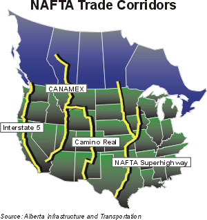
NAFTA superhighway

Last updated
NAFTA superhighway
Interstate 29 and Interstate 35, described by the Ministry of Transportation for the province of Alberta as the "NAFTA superhighway"'"`UNIQ--ref-00000000-QINU`"'

The NAFTA superhighway is a term sometimes used informally to refer to certain existing and proposed highways intended to link Canada, Mexico, and the United States. [1] [2] [3] Although the term has not been used publicly by governments in an official policy context, there are some dissident beliefs about this appellation that are associated with nationalist conspiracy theories regarding alleged secret plans to undermine U.S. sovereignty. [4] [5] [6] Development of these routes is supported by the North American SuperCorridor Coalition as part of a NASCO Corridor. These include Interstate 35 from Laredo, Texas to the Canadian border that downgrades to a non-freeway route ending at Thunder Bay, Ontario, and Interstate 29, a spur that also downgrades to a regular highway at the border and continues to Winnipeg, Manitoba.

The term is also sometimes used to describe some additional partly-built or proposed highways and supercorridors which are intended to connect the road systems of the three nations of the North American Free Trade Agreement (NAFTA) trade bloc. Interstate 69, which runs from Port Huron, Michigan, near the US-Canada border, to western Kentucky, is one among them. Ontario Highway 402 and other motorways in the Windsor-Quebec City Corridor in Canada might be viewed as an extension of this NAFTA superhighway to the northeast. There is now not a single motorway that has been finished in the southwest, from western Kentucky to the Mexican border. While I-69 is being built, the main routes to Mexico currently consist of portions of US Routes 45 and 51 from Kentucky to western Tennessee, I-155 from Tennessee to Missouri, portions of Interstates 55 and 40 from Missouri to Arkansas, and I-30 from Arkansas to the Texas portion of I-35, the original Nafta Superhighway that runs south to the Mexican border at Laredo, Texas. The uncompleted section of I-69 south of Kentucky is expected to eventually continue southwestward to the Texas Gulf Coast. It will have a spur linking to the original Pan-American Highway route through Mexico to Laredo, and additional branches extending to the Mexican spurs that cross the border at Pharr, Texas, and Brownsville, Texas.

The CANAMEX Corridor is another major route that links the three NAFTA countries. It includes Mexican Federal Highway 15, American I-19 and I-15, and Alberta highway 2. The route is sometimes referenced as part of the NAFTA superhighway concept, but it already has a name of its own. In addition to the major north–south corridors that link the Canadian and Mexican borders, Interstate 94 is an important east–west inland freeway (not coast-to-coast like most of the other major east–west interstates) that directly or indirectly links the corridors. I-94 starts near the CANAMEX Corridor in Montana (Interstate 90 bridges the gap thereby providing an indirect link) then follows a northerly route just south of the Canadian border to intersect fully with the I-29 and I-35 routes of the "NAFTA Superhighway". Further east, it links Chicago and the Windsor-Quebec City Corridor that has its western terminus at the Port Huron border crossing. The Canadian corridor is a de facto continuation of I-94 and I-96 to and from eastern Canada. It is also linked by I-94 to the Chicago-Kansas City Expressway that follows a more southerly route to and from I-35. The importance of the Port Huron border crossing is enhanced by the fact that I-69 connects to the Windsor-Quebec City Corridor at the same bridge as I-94.

See also

Related Research Articles

<span class="mw-page-title-main">Interstate 35</span> Interstate Highway from Texas to Minnesota

Interstate 35 (I-35) is a major Interstate Highway in the central United States. As with most primary Interstates that end in a five, it is a major cross-country, north–south route. It stretches from Laredo, Texas, near the Mexican border to Duluth, Minnesota, at Minnesota State Highway 61 and 26th Avenue East. The highway splits into I-35E and I-35W in two separate places, the Dallas–Fort Worth metroplex in Texas and at the Minnesota twin cities of Minneapolis–Saint Paul.

<span class="mw-page-title-main">Interstate 69</span> Interstate Highway from Texas to Michigan

Interstate 69 (I-69) is an Interstate Highway in the United States currently consisting of 10 unconnected segments with an original continuous segment from Indianapolis, Indiana, northeast to the Canadian border in Port Huron, Michigan, at 355.8 miles (572.6 km). The remaining separated segments are variously completed and posted or not posted sections of an extension southwest to the Mexican border in Texas. Of this extension—nicknamed the NAFTA Superhighway because it would help trade with Canada and Mexico spurred by the North American Free Trade Agreement (NAFTA)—seven pieces in Laredo, Texas; Pharr, Texas; Brownsville, Texas; Corpus Christi, Texas; Houston, Texas; northwestern Mississippi; and Memphis, Tennessee, have been built or upgraded and signposted as I-69. Indiana is currently working on a fifth segment that will extend I-69 through the entire state while a sixth segment of I-69 through Kentucky utilizing that state's existing parkway system and a section of I-24 was established by federal legislation in 2008 with several more parkway segments being upgraded since then. This brings the total length to about 880 miles (1,420 km).

<span class="mw-page-title-main">Pan-American Highway</span> Network of roads in the Americas

The Pan-American Highway is a network of roads stretching across the Americas, measuring about 30,000 kilometres (19,000 mi) in total length. Except for a break of approximately 100 km (60 mi) across the border between Colombia and Panama, the roads link most of the Pacific coastal countries of North America and South America in a connected highway system. According to Guinness World Records, the Pan-American Highway is the world's longest "motorable road".

<span class="mw-page-title-main">U.S. Route 81</span> Numbered U.S. Highway in the United States

U.S. Route 81 or U.S. Highway 81 (US 81) is a major north–south U.S. highway that extends for 1,220 miles (1,960 km) in the central United States and is one of the original United States Numbered Highways established in 1926 by the American Association of State Highway Officials.

<span class="mw-page-title-main">U.S. Route 59</span> US highway that runs from Canada to Mexico

U.S. Route 59 is a north–south United States highway. A latecomer to the U.S. numbered route system, US 59 is now a border-to-border route, part of the NAFTA Corridor Highway System. It parallels U.S. Route 75 for nearly its entire route, never much more than 100 miles (160 km) away, until it veers southwest in Houston, Texas. Its number is out of place since US 59 is either concurrent with or entirely west of U.S. Route 71. The highway's northern terminus is 9 mi (14 km) north of Lancaster, Minnesota, at the Lancaster–Tolstoi Border Crossing on the Canada–US border, where it continues as Manitoba Highway 59. Its southern terminus is at the Mexico–US border in Laredo, Texas, where it continues as Mexican Federal Highway 85D.

The Trans-Texas Corridor (TTC) was a proposal for a transportation network in the U.S. State of Texas that was conceived to be composed of a new kind of transportation modality known as supercorridors. The TTC was initially proposed in 2001 and after considerable controversy was discontinued by 2010 in the planning and early construction stages.

The CANAMEX corridor is a series of improvements to freeways and other transportation infrastructure linking Canada to Mexico through the United States. The corridor was established under the North American Free Trade Agreement. Currently the corridor is defined by a series of highways. However, the corridor is also proposed for use by railroads and fiber optic telecommunications infrastructure.

<span class="mw-page-title-main">North American SuperCorridor Coalition</span>

The North America's Corridor Coalition (NASCO) is a non-profit organization that seeks to develop an international multi-modal transportation system along the International Mid-Continent Trade Corridor, which it claims will improve trade competitiveness and quality of life in North America.

<span class="mw-page-title-main">Texas State Highway Loop 20</span> Loop highway around Laredo, Texas

Loop 20, also known as the Bob Bullock Loop and Cuatro Vientos Road, is a highway loop that runs to the north and east of the city of Laredo, Texas. Loop 20 extends from the World Trade International Bridge at its northern point to Mangana-Hein Road at its southern point. The current route varies in construction from a 2-lane road to a freeway with frontage roads.

<span class="mw-page-title-main">U.S. Route 83 in Texas</span> Highway in Texas

U.S. Highway 83 (US 83), dedicated as the Texas Vietnam Veterans Memorial Highway, is a U.S. Highway in the U.S. state of Texas that begins at US 77 in Brownsville and follows the Rio Grande to Laredo, then heads north through Abilene to the Oklahoma state line north of Perryton, the seat of Ochiltree County.

<span class="mw-page-title-main">U.S. Route 59 in Texas</span> Section of U.S. Numbered Highway in Texas, United States

U.S. Highway 59 (US 59) in the U.S. state of Texas is named the Lloyd Bentsen Highway, after Lloyd Bentsen, former U.S. senator from Texas. In northern Houston, US 59, co-signed with Interstate 69 (I-69), is the Eastex Freeway. To the south, which is also co-signed with I-69, it is the Southwest Freeway. The stretch of the Southwest Freeway just west of The Loop was formerly one of the busiest freeways in North America, with a peak AADT of 371,000 in 1998.

The Ports to Plains Corridor, also known as National Highway System High Priority Corridor 38, is a highway corridor between the United States Mexico border at Laredo, Texas and Denver, Colorado. It is the southern third of the Ports-to-Plains Alliance. The reason for proposed improvements to this corridor is to expedite the transportation of goods and services from Mexico in the United States and vice versa. The proposed improvements gained momentum with the signing of the FY22 Omnibus Appropriations bill, which designated a section of the highway part of the interstate system. The Ports-To-Plains Corridor starts in South Texas and traverses through Texas, New Mexico, Oklahoma, and ends in Denver, Colorado.

<span class="mw-page-title-main">Interstate 69 in Texas</span> Interstate Highway in Texas

Interstate 69 (I-69) is an Interstate Highway that is in the process of being built in the US state of Texas. It is part of a longer I-69 extension known as the NAFTA superhighway, that, when completed, will connect Canada to Mexico. In Texas, it will connect Tenaha and the Louisiana segment of the route through the eastern part of the state and along the Texas Gulf Coast to Victoria, where it will split into three branches: I-69E to Brownsville, I-69C to Pharr, and I-69W to Laredo. The first segment of I-69 in Texas was opened in 2011 near Corpus Christi. The American Association of State Highway and Transportation Officials (AASHTO) approved an additional 58 miles (93 km) of US 77 from Brownsville to the Willacy–Kenedy county line for designation as I-69, which was to be signed as I-69E upon concurrence from the Federal Highway Administration (FHWA). FHWA approval for this segment was announced on May 29, 2013. By March 2015, a 74.9-mile (120.5 km) section of US 59 had been completed and designated as I-69 through Greater Houston. As of 2023, short segments near the southern terminuses of the three branch routes have also all been completed. These branches are planned to be connected.

<span class="mw-page-title-main">North American Union</span> Theoretical economic and political continental union of Canada, Mexico, and the United States

The North American Union (NAU) is a theoretical economic and political continental union of Canada, Mexico and the United States, the three largest and most populous countries in North America. The concept is loosely based on the European Union, occasionally including a common currency called the amero or the North American Dollar. A union of the North American continent, sometimes extending to Central and South America, has been the subject of academic concepts for over a century, as well as becoming a common trope in science fiction. One reason for the difficulty in realizing the concept is that individual developments in each region have failed to prioritize a larger union. Some form of union has been discussed or proposed in academic, business, and political circles for decades. However, government officials from all three nations say there are no plans to create a North American Union and that no agreement to do so has been proposed, much less signed. The formation of a North American Union has been the subject of various conspiracy theories.

The CanAm Highway is an international highway that connects Mexico to Canada through the United States. It travels along U.S. Route 85 (US 85) and Interstate 25 (I-25), passing through six U.S. states and the Canadian province of Saskatchewan. The CanAm highway in Canada comprises Saskatchewan Highway 35, SK 39, SK 6, SK 3, and SK 2. The route continues south in Mexico as Mexican Federal Highway 45, and north in Canada as SK 102 but are not labeled the CanAm highway.

<span class="mw-page-title-main">Great Lakes megalopolis</span> Cities around the Great Lakes of North America

The Great Lakes megalopolis consists of a bi-national group of metropolitan areas in North America largely in the Great Lakes region. It extends from the Midwestern United States in the south and west to western Pennsylvania and Western New York in the east and northward through Southern Ontario into southwestern Quebec in Canada. It is the most populated and largest megalopolis in North America.

<span class="mw-page-title-main">Interstate 2</span> Interstate Highway in South Texas

Interstate 2 (I-2) is a partially completed Interstate Highway running through the Lower Rio Grande Valley of South Texas. It begins at the intersection of US Highway 83 (US 83) and Business US 83 in Peñitas and heads eastward before terminating at I-69E/US 77/US 83 in Harlingen. A westward extension around La Joya has been partially completed, but not yet part of I-2. For almost its entire length, I-2 runs concurrently with US 83. I-2 also parallels Mexican Federal Highway 2 (Fed. 2), another major east–west route that traces the Mexico–US border along the Mexican side of the Rio Grande. When completed, the western terminus will be the city of Laredo. The route is one of the more recently designated Interstate Highways; it was signed as an Interstate in 2013. Its construction is part of an expansion of the Interstate System into southern Texas that includes the three branches of I-69. It currently intersects I-69E and I-69C and will, when completed to Laredo, terminate I-69W as well. This complex of Interstate Highways does not yet connect to the rest of the system.

<span class="mw-page-title-main">Interstate 69W</span> Interstate Highway in South Texas

Interstate 69W (I-69W) is a relatively short north–south Interstate Highway running through South Texas in the United States. The freeway begins northeast of the middle of World Trade International Bridge in Laredo and ends at I-35. In the future, I-69W will head northeast for 180 miles (290 km) before terminating near Victoria as both I-69E and I-69W merge to form I-69. For its entire length, I-69W runs concurrently with U.S. Highway 59 (US 59).

References

  1. Jerome Corsi (June 12, 2006). "Bush Administration Quietly Plans NAFTA Super Highway". Human Events. Retrieved 18 August 2011.
  2. Mark Robinowitz (May 10, 2006). "Peak Traffic: Planning NAFTA Superhighways at the End of the Age of Oil". From the Wilderness. Archived from the original on October 8, 2009. Retrieved 18 August 2011.
  3. Ron Paul (October 31, 2006). "The NAFTA Superhighway". Lewrockwell. Retrieved 18 August 2011.
  4. "Highway To Hell? Ron Paul's worked up about U.S. sovereignty". Newsweek. December 1, 2007. Retrieved 18 August 2011.
  5. "Wrong Paul: Fantasy, fallacy and factual fumbles from the Republican insurgent". Factcheck. February 11, 2008. Retrieved 18 August 2011.
  6. Shane Dingman (December 5, 2007). "Ron Paul's worst nightmare comes true? NAFTA Superhighway a reality". The National Post. Retrieved 18 August 2011.