Polk County | |
---|---|
Coordinates: 30°48′N94°50′W / 30.8°N 94.83°W | |
Country | United States |
State | Texas |
Founded | March 30, 1846 |
Named for | James K. Polk |
Seat | Livingston |
Largest town | Livingston |
Area | |
• Total | 1,110 sq mi (2,900 km2) |
• Land | 1,057 sq mi (2,740 km2) |
• Water | 53 sq mi (140 km2) 4.74% |
Population (2020) | |
• Total | 50,123 |
• Estimate (2023) | 50,123 |
• Density | 45/sq mi (17/km2) |
Time zone | UTC−6 (Central) |
• Summer (DST) | UTC−5 (CDT) |
ZIP Codes | 75934, 75936, 75939, 75960, 77326, 77335, 77350, 77351, 77360, 77364 |
Area code | 936 |
Congressional district | 8th |
Website | www |
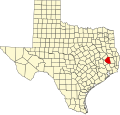
Polk County is a county located in the U.S. state of Texas. As of the 2020 census, its population was 50,123. [1] Its county seat is Livingston. [2] The county is named after James K. Polk. The Alabama-Coushatta Indian Reservation of the federally recognized tribe is in Polk County, where the people have been since the early 19th century. They were forcibly evicted by the federal government from their traditional territory in the Southeast. [3] The 2000 census reported a resident population of 480 persons on the reservation. The tribe reports 1100 enrolled members.
Polk County, named for James Knox Polk of Tennessee, President of the United States, was created by an act of the first Legislature of the State of Texas, approved on March 30, 1846, out of Liberty County, and embraced that portion from the part designated as the "Northern Division" of said county. It was one of the first of a series of 23 counties, formulated, constituted, and established by the State of Texas, after annexation to the United States. [4]
Census | Pop. | Note | %± |
---|---|---|---|
1850 | 2,348 | — | |
1860 | 8,300 | 253.5% | |
1870 | 8,707 | 4.9% | |
1880 | 7,189 | −17.4% | |
1890 | 10,332 | 43.7% | |
1900 | 14,447 | 39.8% | |
1910 | 17,459 | 20.8% | |
1920 | 16,784 | −3.9% | |
1930 | 17,555 | 4.6% | |
1940 | 20,635 | 17.5% | |
1950 | 16,194 | −21.5% | |
1960 | 13,861 | −14.4% | |
1970 | 14,457 | 4.3% | |
1980 | 24,407 | 68.8% | |
1990 | 30,687 | 25.7% | |
2000 | 41,133 | 34.0% | |
2010 | 45,413 | 10.4% | |
2020 | 50,123 | 10.4% | |
U.S. Decennial Census [5] 1850–2010 [6] 2010 [7] 2020 [8] |
Race / Ethnicity (NH = Non-Hispanic) | Pop 2000 [9] | Pop 2010 [7] | Pop 2020 [8] | % 2000 | % 2010 | % 2020 |
---|---|---|---|---|---|---|
White alone (NH) | 30,723 | 32,830 | 34,808 | 74.69% | 72.29% | 69.45% |
Black or African American alone (NH) | 5,357 | 5,153 | 4,869 | 13.02% | 11.35% | 9.71% |
Native American or Alaska Native alone (NH) | 649 | 778 | 914 | 1.58% | 1.71% | 1.82% |
Asian alone (NH) | 156 | 180 | 340 | 0.38% | 0.40% | 0.68% |
Pacific Islander alone (NH) | 3 | 7 | 0 | 0.01% | 0.02% | 0.00% |
Other Race alone (NH) | 5 | 14 | 135 | 0.01% | 0.03% | 0.27% |
Mixed Race or Multiracial (NH) | 379 | 492 | 1,712 | 0.92% | 1.08% | 3.42% |
Hispanic or Latino (any race) | 3,861 | 5,959 | 7,345 | 9.39% | 13.12% | 14.65% |
Total | 41,133 | 45,413 | 50,123 | 100.00% | 100.00% | 100.00% |
As of the census [10] of 2000, 41,133 people, 15,119 households, and 10,915 families were residing in the county. The population density was 39 inhabitants per square mile (15/km2). The 21,177 housing units averaged 20 per square mile (7.7/km2). The racial makeup of the county was 79.64% White, 13.17% African American, 1.74% Native American, 0.38% Asian, 3.75% from other races, and 1.32% from two or more races. About 9.39% of the population was Hispanic or Latino of any race.
Of the 15,119 households, 28.80% had children under the age of 18 living with them, 57.90% were married couples living together, 10.80% had a female householder with no husband present, and 27.80% were not families. About 24.60% of all households were made up of individuals, and 12.50% had someone living alone who was 65 years of age or older. The average household size was 2.50, and the average family size was 2.95.
In the county, the population was distributed as 22.90% under the age of 18, 8.10% from 18 to 24, 26.80% from 25 to 44, 24.20% from 45 to 64, and 18.00% who were 65 years of age or older. The median age was 39 years. For every 100 females there were 108.70 males. For every 100 females age 18 and over, there were 109.50 males.
The median income for a household in the county was $30,495, and for a family was $35,957. Males had a median income of $30,823 versus $21,065 for females. The per capita income for the county was $15,834. About 13.30% of families and 17.40% of the population were below the poverty line, including 23.10% of those under age 18 and 12.30% of those age 65 or over.
According to the U.S. Census Bureau, the county has a total area of 1,110 sq mi (2,900 km2), of which 53 sq mi (140 km2) (4.7%) are covered by water. [11]
School districts: [12]
The county is in the district for Angelina College. [13] Polk County College / Commerce Center was completed in 2013 and is located on the U.S. Highway 59 Bypass. Angelina College offers advanced curriculum study and technical training at this location. The facility provides public auditorium space and may be used as a mass shelter in a disaster event. [14]
Position | Name | Party | |
---|---|---|---|
County Judge | Sydney Murphy | Republican | |
Commissioner, Precinct 1 | Guylene Robertson | Republican | |
Commissioner, Precinct 2 | Mark Dubose | Republican | |
Commissioner, Precinct 3 | Milton Purvis | Republican | |
Commissioner, Precinct 4 | Jerry Cassity | Republican |
The Texas Department of Criminal Justice Allan B. Polunsky Unit is located in West Livingston. [15] [16] This has been the location of the Texas men's death row since 1999. [17]
Greyhound Lines operates the Livingston Station at the Super Stop Food Mart in Livingston. [18]
West Livingston has the Livingston Municipal Airport, operated by the City of Livingston. [15] [19]
Senators | Name | Party | First Elected | Level | |
---|---|---|---|---|---|
Senate Class 1 | John Cornyn | Republican | 1993 | Senior Senator | |
Senate Class 2 | Ted Cruz | Republican | 2012 | Junior Senator | |
Representatives | Name | Party | First Elected | Area(s) of Polk County Represented | |
District 8 | Morgan Lutrell | Republican | 2022 | Entire county |
Year | Republican | Democratic | Third party(ies) | |||
---|---|---|---|---|---|---|
No. | % | No. | % | No. | % | |
2024 | 19,216 | 79.11% | 4,910 | 20.21% | 165 | 0.68% |
2020 | 18,573 | 76.79% | 5,387 | 22.27% | 226 | 0.93% |
2016 | 15,176 | 76.45% | 4,187 | 21.09% | 489 | 2.46% |
2012 | 14,071 | 73.54% | 4,859 | 25.39% | 204 | 1.07% |
2008 | 13,731 | 68.15% | 6,230 | 30.92% | 188 | 0.93% |
2004 | 13,778 | 66.09% | 6,964 | 33.41% | 104 | 0.50% |
2000 | 11,746 | 61.84% | 6,877 | 36.21% | 371 | 1.95% |
1996 | 6,473 | 45.44% | 6,360 | 44.65% | 1,411 | 9.91% |
1992 | 5,390 | 37.81% | 5,942 | 41.69% | 2,922 | 20.50% |
1988 | 5,831 | 48.88% | 5,943 | 49.82% | 155 | 1.30% |
1984 | 5,987 | 60.36% | 3,898 | 39.30% | 33 | 0.33% |
1980 | 3,771 | 46.51% | 4,213 | 51.96% | 124 | 1.53% |
1976 | 2,529 | 36.30% | 4,384 | 62.93% | 54 | 0.78% |
1972 | 3,048 | 63.13% | 1,760 | 36.45% | 20 | 0.41% |
1968 | 1,013 | 22.18% | 1,841 | 40.31% | 1,713 | 37.51% |
1964 | 1,199 | 32.41% | 2,492 | 67.35% | 9 | 0.24% |
1960 | 1,268 | 37.74% | 2,037 | 60.63% | 55 | 1.64% |
1956 | 1,663 | 52.89% | 1,465 | 46.60% | 16 | 0.51% |
1952 | 1,454 | 39.36% | 2,238 | 60.58% | 2 | 0.05% |
1948 | 317 | 13.96% | 1,422 | 62.64% | 531 | 23.39% |
1944 | 154 | 6.83% | 1,817 | 80.61% | 283 | 12.56% |
1940 | 280 | 9.58% | 2,642 | 90.42% | 0 | 0.00% |
1936 | 141 | 8.01% | 1,618 | 91.93% | 1 | 0.06% |
1932 | 110 | 4.93% | 2,117 | 94.98% | 2 | 0.09% |
1928 | 508 | 33.73% | 994 | 66.00% | 4 | 0.27% |
1924 | 272 | 12.70% | 1,839 | 85.85% | 31 | 1.45% |
1920 | 255 | 19.84% | 810 | 63.04% | 220 | 17.12% |
1916 | 107 | 9.39% | 918 | 80.60% | 114 | 10.01% |
1912 | 41 | 5.26% | 615 | 78.85% | 124 | 15.90% |
Walker County is a county located in the east central section of the U.S. state of Texas. As of the 2020 census, its population was 76,400. Its county seat is Huntsville. Initially, Walker County was named for Robert J. Walker, a legislator from Mississippi who introduced into the United States Congress the resolution to annex Texas. Walker later supported the U.S. during its Civil War and earned some enmity for it. In order to keep the county's name, the state renamed it for Samuel H. Walker, a Texas Ranger and soldier in the United States Army.
Tyler County is a county located in the U.S. state of Texas. It is in East Texas and its seat is Woodville. As of the 2020 census, its population was 19,798. Tyler County is named for John Tyler, the 10th President of the United States. Despite its name, Tyler County does not contain the city of Tyler, Texas; the latter is located about 140 miles to the north in Smith County.
Trinity County is a county located in the U.S. state of Texas. As of the 2020 census, the population was 13,602. Its county seat is Groveton. The county is named for the Trinity River.
San Jacinto County is a county in the U.S. state of Texas. As of the 2020 census, its population was 27,402. Its county seat is Coldspring. The county's name comes from the Battle of San Jacinto which secured Texas' independence from Mexico and established a republic in 1836.
San Augustine County is a county located in the U.S. state of Texas. As of the 2020 census, its population was 7,918. Its county seat is San Augustine.
Rains County is a county located in the U.S. state of Texas. As of the 2020 census, its population was 12,164. Its seat is Emory. The county are named for Emory Rains, a Texas state legislator.
Nueces County is located in the U.S. state of Texas. As of the 2020 census, the population was 353,178, making it the 16th-most populous county in the state. The county seat is Corpus Christi. The county was formed in 1846 from portions of San Patricio County and organized the following year. It is named for the Nueces River, which marks the county's northwestern boundary with San Patricio County before emptying into its mouth at Nueces Bay north of the port of Corpus Christi. Nueces County is part of the Corpus Christi metropolitan statistical area.
Newton County is the easternmost county in the U.S. state of Texas. As of the 2020 census, its population was 12,217. Its county seat is Newton. The county is named for John Newton, a veteran of the American Revolutionary War.
Nacogdoches County is a county located in the U.S. state of Texas. As of the 2020 census, its population was 64,653. Its county seat is Nacogdoches.
Jasper County is a county located in the U.S. state of Texas. As of the 2020 census, its population was 32,980. Its county seat is Jasper. The county was created as a municipality in Mexico in 1834, and in 1837 was organized as a county in the Republic of Texas. It is named for William Jasper, an American Revolutionary War hero.
Jackson County is a county in the U.S. state of Texas. As of the 2020 census its population was 14,988. Its county seat is Edna. The county was created in 1835 as a municipality in Mexico and in 1836 was organized as a county. It is named for Andrew Jackson, President of the United States from 1829 to 1837.
Houston County is a county located in the U.S. state of Texas. As of the 2020 census, its population was 22,066. Its county seat is Crockett. Houston County was one of 46 entirely dry counties in the state of Texas, until voters in a November 2007 special election legalized the sale of alcohol in the county.
Cherokee County is a county located in the U.S. state of Texas. As of the 2020 census, its population was 50,412. The county seat is Rusk, which lies 130 miles southeast of Dallas and 160 miles north of Houston. The county was named for the Cherokee, who lived in the area before being expelled in 1839. Cherokee County comprises the Jacksonville micropolitan statistical area, which is also included in the Tyler–Jacksonville combined statistical area.
Bee County is a county located in the U.S. state of Texas. It is in South Texas and its county seat is Beeville. As of the 2020 census, its population was 31,047. The Beeville, TX micropolitan statistical area includes all of Bee County. The county was founded December 8, 1857, and organized the next year. It is named for Barnard E. Bee, Sr., a secretary of state of the Republic of Texas.
Angelina County is a county located in the U.S. state of Texas. It is in East Texas and its county seat is Lufkin.
Corrigan is a town in north central Polk County, Texas, United States. It is located along U.S. Highway 59 and is approximately 100 miles from Houston. Its population was 1,477 in the 2020 census.
Livingston is a town in and the county seat of Polk County, Texas, United States. With a population of 5,640 at the 2020 census, it is the largest city in Polk County. It is located approximately 46 miles (74 km) south of Lufkin and roughly 74 miles (119 km) northeast of Houston and was originally settled in 1835 as Springfield. Its name was changed in 1846 to Livingston, when it was designated as the county seat of Polk County.
Seven Oaks is a city in Polk County, Texas, United States. The population was 68 at the 2020 census.
West Livingston is a census-designated place (CDP) in western Polk County, Texas, United States, located along the eastern shore of Lake Livingston 6 miles (9.7 km) west of central Livingston. The population was 8,156 at the 2020 census.
Big Thicket Lake Estates is a census-designated place (CDP) in Polk and Liberty counties, Texas, United States. This was a new CDP for the 2010 census, with a population of 742, decreasing to 514 at the 2020 census.
Media related to Polk County, Texas at Wikimedia Commons