Smith County, Texas

Last updated

Smith County
Tyler May 2016 35 (Smith County Courthouse).jpg
Smith County Courthouse in Tyler
Smith County tx seal.png
Map of Texas highlighting Smith County.svg
Location within the U.S. state of Texas
Texas in United States.svg
Texas's location within the U.S.
Coordinates: 32°23′N95°16′W / 32.38°N 95.27°W / 32.38; -95.27
CountryFlag of the United States.svg United States
StateFlag of Texas.svg  Texas
FoundedJuly 1846
Seat Tyler
Largest cityTyler
Area
  Total950 sq mi (2,500 km2)
  Land921 sq mi (2,390 km2)
  Water28 sq mi (70 km2)  3.0%
Population
 (2020)
  Total233,479
  Estimate 
(2021)
237,186
  Density250/sq mi (95/km2)
Time zone UTC−6 (Central)
  Summer (DST) UTC−5 (CDT)
Congressional district 1st
Website www.smith-county.com

Smith County is a county in the U.S. state of Texas. As of the 2020 census, its population was 233,479. [1] Its county seat is Tyler. [2] Smith County is named for James Smith, a general during the Texas Revolution.

Contents

Smith County is part of the Tyler metropolitan statistical area and the Tyler–Jacksonville combined statistical area.

History

Smith County veterans display, the Wall of Memories, in Tyler Plaza Wall of Memories, Tyler, TX IMG 0472.JPG
Smith County veterans display, the Wall of Memories, in Tyler Plaza
Confederate States of America memorial in Tyler Plaza Confederate memorial, Smith County, TX IMG 0477.JPG
Confederate States of America memorial in Tyler Plaza
Korean War Memorial in Tyler Plaza Korean War Veterans Memorial, Tyler, TX IMG 0491.JPG
Korean War Memorial in Tyler Plaza

For thousands of years, indigenous peoples occupied this area of present-day Texas. The first known inhabitants of the area now known as Smith County were the Caddo Indians, who were recorded here until 1819. That year, a band of Cherokee, led by their chief, "The Bowl" (also known as Chief Bowles), migrated from Georgia and settled in what are now Smith and Rusk counties. [3] The Treaty of Bowles Village on February 23, 1836, between the Republic of Texas and the Cherokee and 12 affiliated tribes, gave all of Smith and Cherokee counties, as well as parts of western Rusk County, southern Gregg (formed from Rusk County in 1873) and southeastern Van Zandt counties to the tribes. [4]

Native Americans remained on these lands until the Cherokee War in the summer of 1839, as part of European-American conflicts with Native Americans in Texas. The Cherokee were driven out of Smith County. In this period, Cherokee and other Native American nations were forced from the Southeast United States to west of the Mississippi River to Indian Territory during Indian Removal.

After 1845, some Cherokee returned when Benjamin Franklin Thompson, a white man married to a Cherokee, purchased 10,000 acres of land in Rusk County and allowed them to settle. The Mount Tabor Indian Community developed here, [5] some six miles south of present-day Kilgore. The community later grew and incorporated areas near Overton, Arp, and Troup, Texas.

In July 1846, Smith County separated from the Nacogdoches District and was named for James Smith, a general of the Texas Revolution. At this time, Tyler was designated as the county seat. [6]

Camp Fanin, a World War II US army replacement training facility, was located in the area known as Owentown, northeast of Tyler along US Hwy 271. Many of its original buildings still exist.

During the American Civil War, Camp Ford was the largest Confederate prisoner-of-war camp west of the Mississippi River. Here, Sheriff Jim Reed of Collin County and Judge McReynolds, former chief justice of the district, were seized and lynched by "Regulators".

The original site of the camp stockade is now a public historic park owned by Smith County, as such it is exempted from making any County property tax contribution, and is managed by the Smith County Historical Society. The park contains a kiosk, a paved trail, interpretive signage, a cabin reconstruction, and a picnic area. To date, it has never been the site of a paid venue, nor public event. It is located on Highway 271, 0.8 miles north of Loop 323.

20th century to present

The Smith County Historical Society, a 501(c)(3) nonprofit organization, was founded in 1959 by individuals and business firms dedicated to discovering, collecting, and preserving data, records, and other items relating to the history of Smith County. More information can be found at the Smith County Historical Society Website. [7]

Geography

According to the U.S. Census Bureau, the county has a total area of 950 square miles (2,500 km2), of which 921 square miles (2,390 km2) are land and 28 square miles (73 km2) (3.0%) are covered by water. [8]

The county infrastructure includes some 1,180 miles (1,900 km) of two-lane county road.

Major highways

Adjacent counties

Communities

Cities

Towns

Census-designated place

Unincorporated communities

Ghost towns

Demographics

Historical population
CensusPop.Note
1850 4,292
1860 13,392212.0%
1870 16,53223.4%
1880 21,86332.2%
1890 28,32429.6%
1900 37,37031.9%
1910 41,74611.7%
1920 46,76912.0%
1930 53,12313.6%
1940 69,09030.1%
1950 74,7018.1%
1960 86,35015.6%
1970 97,09612.4%
1980 128,36632.2%
1990 151,30917.9%
2000 174,70615.5%
2010 209,71420.0%
2020 233,47911.3%
2022 (est.)241,757 [9] 3.5%
U.S. Decennial Census [10]
1850–2010 [11] 2010 [12] 2020 [13]
Demographic Profile of Smith County, Texas
(NH = Non-Hispanic)
Race / EthnicityPop 2010 [12] Pop 2020 [13] % 2010% 2020
White alone (NH)130,246134,45262.11%57.59%
Black or African American alone (NH)37,19538,00317.74%16.28%
Native American or Alaska Native alone (NH)7347460.35%0.32%
Asian alone (NH)2,5504,1291.22%1.77%
Pacific Islander alone (NH)63770.03%0.03%
Some Other Race alone (NH)2256950.11%0.30%
Mixed Race/Multi-Racial (NH)2,6138,0961.25%3.47%
Hispanic or Latino (any race)36,08847,28117.21%20.25%
Total209,714233,479100.00%100.00%

Note: the US Census treats Hispanic/Latino as an ethnic category. This table excludes Latinos from the racial categories and assigns them to a separate category. Hispanics/Latinos can be of any race.

In the 2010 U.S. census, Smith County had a population of 209,714, up from its 1850 population of 4,292. [12] By the 2020 census, its population increased to 233,479. [13] Among its population in 2010, the racial and ethnic makeup was 62.11% non-Hispanic white, 17.74% Black or African American, 0.35% American Indian or Alaska Native, 1.22% Asian alone, 0.03% Native Hawaiian or other Pacific Islander, 0.11% some other race, 3.47% multiracial, and 17.21% Hispanic or Latino of any race. In 2020, its racial and ethnic makeup was 57.59% non-Hispanic white, 16.28% Black or African American, 0.32% American Indian or Alaska Native, 1.77% Asian alone, 0.03% Native Hawaiian or other Pacific Islander, 0.30% some other race, 3.47% multiracial and 20.25% Hispanic or Latino of any race; 2020's census statistics reflected state and nationwide demographic trends of greater diversification within the U.S. overall. [14] [15]

At the 2021 American Community Survey, Smith County had a median household income of $63,115; its mean household income was $86,661. [16] Among the owner-occupied housing units of the county, the median value was $169,600, and there was a median real estate tax of $2,634. [17] Owner-occupied housing units without a mortgage had a median value of $173,700 and median real estate tax of $2,203. [18] Throughout the county, an estimated 12.51% of the population lived at or below the poverty line. [19]

Politics

Conservative Whites in Smith County began to ally with the Republican Party in 1952, also making it one of three East Texas counties, along with Panola and Gregg, to vote for Barry Goldwater in 1964, when native son Democratic President Lyndon B. Johnson won re-election. At that time, most Blacks and Latinos in the county were still disenfranchised due to the state's discriminatory use of certain barriers. [20] The last Democrat to carry Smith County was incumbent President Harry S. Truman in 1948. [21] No Democrat has gained 30% of the county's vote in the past six elections. The last Democrat to gain more than 40% was Jimmy Carter from Georgia in 1976.

United States presidential election results for Smith County, Texas [22]
Year Republican Democratic Third party
No.%No.%No.%
2020 69,08068.85%29,61529.52%1,6391.63%
2016 58,93069.52%22,30026.31%3,5384.17%
2012 57,33172.02%21,45626.95%8141.02%
2008 55,18769.36%23,72629.82%6480.81%
2004 53,39272.48%19,97027.11%3020.41%
2000 43,32071.46%16,47027.17%8341.38%
1996 32,17159.97%18,26534.05%3,2075.98%
1992 27,75347.03%17,51429.68%13,73923.28%
1988 34,65864.67%18,71934.93%2150.40%
1984 40,74072.60%15,22727.13%1520.27%
1980 28,23664.61%14,83833.95%6261.43%
1976 22,23856.62%16,85642.92%1810.46%
1972 23,67174.37%8,04125.26%1150.36%
1968 12,07939.51%8,89729.10%9,59531.39%
1964 12,96050.88%12,47448.97%380.15%
1960 12,04257.84%8,49440.80%2851.37%
1956 12,25565.21%6,46834.42%690.37%
1952 10,94756.40%8,45043.53%130.07%
1948 3,18128.13%6,47357.24%1,65514.63%
1944 9369.81%6,67169.94%1,93120.25%
1940 1,55714.19%9,41085.74%80.07%
1936 6608.47%7,11691.37%120.15%
1932 7509.15%7,42490.53%270.33%
1928 3,49359.85%2,34340.15%00.00%
1924 1,07918.85%4,47378.16%1712.99%
1920 70715.13%2,96563.45%1,00121.42%
1916 77322.21%2,42269.58%2868.22%
1912 48514.93%1,93659.61%82725.46%

Smith County is represented in the Texas House of Representatives by Matt Schaefer (R) of Tyler and the Texas Senate by Senator Bryan Hughes (R). Its U.S. Representative is Nathaniel Moran (R).

Government and infrastructure

The county is governed by a Commissioners Court, made up of four members elected from single-member districts and a county judge elected at-large.

Smith County ranks 10th in the State of Texas for road miles. The county has 1,170 miles – about the distance from Tyler, Texas to Paradise, Nevada of roads it maintains. The Smith County Road & Bridge Department maintains the county's bridges and roads, including mowing the rights of way.

The $39.5 million Smith County Road Bond passed with 73% of the vote on November 7, 2017. The issuance of bonds was for road and bridge construction and major improvements. Road work around the county is well underway. For a list of road projects in the two-phase, six-year bond program, visit www.smith-county.com.

Officials

Twenty-eight elected officials serve Smith County citizens (county auditor is not an elected position):

Official Function
County judgeCounty administration (as presiding member of the commissioners court) and judicial jurisdiction
Commissioners (four, one per precinct)County administration (commissioners court)
SheriffSecurity and law enforcement
District attorneyLaw enforcement and criminal prosecution
Constables (five, one per precinct)Law enforcement
Justices of the peace (five, one per precinct)Judicial/legal jurisdiction
District clerkJudicial support to district courts
County clerkClerk of record for the county
County tax assessor-collector Collector of property taxes and special fees
County treasurerCounty's chief banker
County court at law judges (three)Judicial/Legal jurisdiction
District judges (four)Judicial/legal jurisdiction

Education

These school districts serve school-aged children in Smith County:

Those wishing to attend institutions of higher learning in the area can attend:

Media

Smith County is part of the Tyler/Longview/Jacksonville DMA. Local media outlets are: KLTV, KTRE-TV, KYTX-TV, KFXK-TV, KCEB-TV, and KETK-TV.

KTBB, an AM radio station based in Tyler, provides a news-talk format to the area.

The daily Tyler Morning Telegraph is the primary newspaper in the county, based in Tyler. Coverage of the area can also be found in the Longview News-Journal , published in Longview, in Gregg County.

See also

Related Research Articles

<span class="mw-page-title-main">Upshur County, Texas</span> County in Texas, United States

Upshur County is a county located in the eastern part of the U.S. state of Texas. As of the 2020 census, the population was 40,892. The county seat is Gilmer. The county is named for Abel P. Upshur, who was U.S. Secretary of State during President John Tyler's administration.

<span class="mw-page-title-main">Tyler County, Texas</span> County in Texas, United States

Tyler County is a county located in the U.S. state of Texas. It is in East Texas and its seat is Woodville.

<span class="mw-page-title-main">Rusk County, Texas</span> County in Texas, United States

Rusk County is a county located in Texas. As of the 2020 census, its population was 52,214. Its county seat is Henderson. The county is named for Thomas Jefferson Rusk, a secretary of war of the Republic of Texas.

<span class="mw-page-title-main">Rains County, Texas</span> County in Texas, United States

Rains County is a county located in the U.S. state of Texas. As of the 2020 census, its population was 12,164. Its seat is Emory. The county are named for Emory Rains, a Texas state legislator.

<span class="mw-page-title-main">Nacogdoches County, Texas</span> County in Texas, United States

Nacogdoches County is a county located in the U.S. state of Texas. As of the 2020 census, its population was 64,653. Its county seat is Nacogdoches.

<span class="mw-page-title-main">Kaufman County, Texas</span> County in Texas, United States

Kaufman County is a county in the northeastern area of the U.S. state of Texas. As of the 2020 census, its population was 145,310. Its county seat is Kaufman. Both the county, established in 1848, and the city were named for David S. Kaufman, a U.S. Representative and diplomat from Texas. Kaufman County is part of the Dallas-Fort Worth-Arlington metropolitan statistical area.

<span class="mw-page-title-main">Gregg County, Texas</span> County in Texas, United States

Gregg County is a county located in the eastern part of the U.S. state of Texas. As of the 2020 census, its population was 124,239. Its county seat is Longview. The county is named after John Gregg, a Confederate general killed in action during the American Civil War.

<span class="mw-page-title-main">Cherokee County, Texas</span> County in Texas, United States

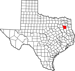
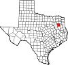
Cherokee County is a county located in the U.S. state of Texas. As of the 2020 census, its population was 50,412. The county seat is Rusk, which lies 130 miles southeast of Dallas and 160 miles north of Houston. The county was named for the Cherokee, who lived in the area before being expelled in 1839. Cherokee County comprises the Jacksonville micropolitan statistical area, which is also included in the Tyler–Jacksonville combined statistical area.
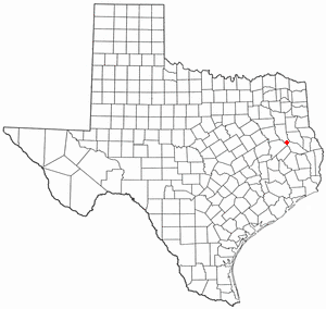
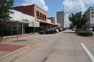
<span class="mw-page-title-main">New Summerfield, Texas</span> City in Texas, United States

New Summerfield is a city in Cherokee County, Texas, United States. The population was 843 at the 2020 U.S. census.

<span class="mw-page-title-main">Rusk, Texas</span> City in Texas, United States

Rusk is a city and the county seat of Cherokee County in the U.S. state of Texas. At the 2020 United States census, it had a population of 5,285.

<span class="mw-page-title-main">Wells, Texas</span> Town in Texas, United States

Wells is a town in Cherokee County, Texas, United States. The population was 790 at the 2010 census, and 853 at the 2020 U.S. census.

<span class="mw-page-title-main">Arp, Texas</span> City in Texas, United States

Arp is a city in Smith County, in the U.S. state of Texas. It is part of the Tyler metropolitan statistical area. According to the United States Census Bureau. The population was 892 in the 2020 census.

<span class="mw-page-title-main">Grand Saline, Texas</span> City in Texas, United States

Grand Saline is a city in Van Zandt County, Texas, United States, located in East Texas. The population was 3,107 as of 2020, making Grand Saline the third-largest city in Van Zandt County. The city is located roughly 75 miles (120 km) east of Dallas and 35 miles (56 km) northwest of Tyler, the two nearest metropolitan areas, and is part of the greater Tyler/Longview area.

<span class="mw-page-title-main">Troup, Texas</span> City in Texas, United States

Troup is a city in Smith and Cherokee Counties in the U.S. state of Texas. Its population was 2,006 at the 2020 census. Troup lies in two counties in East Texas.

<span class="mw-page-title-main">Easton, Texas</span> City in Texas, United States

Easton is a city in Gregg and Rusk counties in the U.S. state of Texas. The population was 510 at the 2010 census, and 499 at the 2020 census.

<span class="mw-page-title-main">Longview, Texas</span> City in Texas, United States

Longview is a city in and county seat of Gregg County, Texas, United States. Longview is located in East Texas, where Interstate 20 and U.S. highways 80 and 259 converge just north of the Sabine River. According to the 2020 U.S. census, the city had a population of 81,638. Longview is the principal city of the Longview metropolitan statistical area, comprising Gregg, Upshur, and Rusk counties. The population of the metropolitan area as of 2021 census estimates was 287,858.

<span class="mw-page-title-main">Overton, Texas</span> City in Texas, United States

Overton is a city in Rusk and Smith counties in the U.S. state of Texas. Overton lies in two counties as well as two metropolitan areas. The Rusk County portion of the city is part of the Longview Metropolitan Statistical Area, while the Smith County portion is part of the Tyler Metropolitan Statistical Area.

<span class="mw-page-title-main">Northeast Texas</span> Region in Texas, United States

Northeast Texas is a cultural and geographic region in the northeast corner of the U.S. state of Texas. Geographically centered on two metropolitan areas strung along Interstate 20—Tyler in the west and Longview/Marshall to the east, the areas of Mount Pleasant, Sulphur Springs, Paris, and Texarkana in the north primarily along Interstate 30, and Jacksonville and Palestine to the south are also major cities within the region. Most of Northeast Texas is included in the interstate region of the Ark-La-Tex.

<span class="mw-page-title-main">Tyler metropolitan area</span> Metropolitan statistical area in Texas, United States

The Tyler metropolitan area, or Greater Tyler area centered on the city of Tyler, Texas, is one of the largest Texan metropolitan areas in East Texas. It had a combined population of 216,080 according to the 2010 U.S. census, and 233,479 in 2020. The Tyler metropolitan area encompasses all of Smith County.

Lake Cherokee is an unincorporated community and census-designated place (CDP) in Gregg and Rusk counties, Texas, United States. Its population was 2,980 as of the 2020 census. Lake Cherokee is located 12 miles southeast of Gregg and northeastern Rusk counties on Cherokee Bayou. The lake is owned by the Cherokee Water Company to supply water for municipal, industrial, and recreational purposes. It has a capacity of 68,700 acre-feet. The lake impounds Cherokee Bayou. The top of the dam is at the elevation of 295 feet above the average sea level, but it has a max design of 291 feet above the average sea level. Lake Cherokee is located 12 miles southeast of Gregg and northeastern Rusk counties on Cherokee Bayou. The lake is owned by the Cherokee Water Company to supply water for municipal, industrial, and recreational purposes.

References

  1. "Smith County, Texas". United States Census Bureau . Retrieved January 30, 2022.
  2. "Find a County". National Association of Counties. Retrieved June 7, 2011.
  3. Clarke, Mary Whatley (1971). Chief Bowles and the Texas Cherokees: A History. p. 17.
  4. Winfrey, Day (1825–1916). Indian Papers of Texas, Volume I: Treaty between Texas and the Cherokee Indians. pp. 14–17.
  5. Pynes, Patrick (2007). Historic Origins of the Mount Tabor Indian Community: Northern Arizona University. p. 74.
  6. Texas State Historical Association Online. "Smith County". Texas State Historical Association. Retrieved May 7, 2012.
  7. "To discover, collect and preserve the history of Smith County". Smith County Historical Society. Retrieved August 15, 2015.
  8. "2010 Census Gazetteer Files". United States Census Bureau. August 22, 2012. Retrieved May 10, 2015.
  9. "Smith County, Texas Population 2022". World Population Review. Retrieved July 7, 2022.
  10. "Decennial Census of Population and Housing by Decades". US Census Bureau.
  11. "Texas Almanac: Population History of Counties from 1850–2010" (PDF). Texas Almanac. Archived (PDF) from the original on October 9, 2022. Retrieved May 10, 2015.
  12. 1 2 3 "P2 HISPANIC OR LATINO, AND NOT HISPANIC OR LATINO BY RACE - 2010: DEC Redistricting Data (PL 94-171) - Smith County, Texas". United States Census Bureau .
  13. 1 2 3 "P2 HISPANIC OR LATINO, AND NOT HISPANIC OR LATINO BY RACE - 2020: DEC Redistricting Data (PL 94-171) - Smith County, Texas". United States Census Bureau .
  14. Frey, William H. (July 1, 2020). "The nation is diversifying even faster than predicted, according to new census data". Brookings. Retrieved May 23, 2022.
  15. "America is becoming more urban, more diverse and less white, 2020 Census reveals". PBS NewsHour. August 12, 2021. Retrieved May 23, 2022.
  16. "S1901 INCOME IN THE PAST 12 MONTHS (IN 2021 INFLATION-ADJUSTED DOLLARS) - 2021: ACS 1-Year Estimates - Smith County, Texas". United States Census Bureau . July 1, 2021.
  17. "S2506 FINANCIAL CHARACTERISTICS FOR HOUSING UNITS WITH A MORTGAGE - 2021: ACS 1-Year Estimates - Smith County, Texas". July 1, 2021.
  18. "S2507 FINANCIAL CHARACTERISTICS FOR HOUSING UNITS WITHOUT A MORTGAGE - 2021: ACS 1-Year Estimates - Smith County, Texas". United States Census Bureau . July 1, 2021.
  19. "S1701 POVERTY STATUS IN THE PAST 12 MONTHS- 2021: ACS 1-Year Estimates - Smith County, Texas". United States Census Bureau . July 1, 2021.
  20. "5.3 Historical Barriers to Voting", Texas Politics, University of Texas website, 2018
  21. The Political Graveyard; Smith County, Texas
  22. Leip, David. "Dave Leip's Atlas of U.S. Presidential Elections". uselectionatlas.org. Retrieved April 4, 2018.

32°23′N95°16′W / 32.38°N 95.27°W / 32.38; -95.27