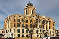
Cooke County | |
---|---|
Coordinates: 33°38′00″N97°13′00″W / 33.633333333333°N 97.216666666667°W | |
Country | United States |
State | Texas |
Founded | 1849 |
Seat | Gainesville |
Largest city | Gainesville |
Area | |
• Total | 898 sq mi (2,330 km2) |
• Land | 875 sq mi (2,270 km2) |
• Water | 24 sq mi (60 km2) 2.6% |
Population (2020) | |
• Total | 41,668 |
• Density | 46/sq mi (18/km2) |
Time zone | UTC−6 (Central) |
• Summer (DST) | UTC−5 (CDT) |
Congressional district | 26th |
Website | www |
Cooke County is a county in the U.S. state of Texas. At the 2020 census, its population was 41,668. [1] [2] The county seat is Gainesville. [3] The county was founded in 1848 and organized the next year. It is named for William Gordon Cooke, a soldier during the Texas Revolution. It is a part of the Texoma region.
Cooke County comprises the Gainesville, TX micropolitan statistical area, which is also included in the Dallas–Fort Worth, TX-OK combined statistical area.
According to the U.S. Census Bureau, the county has an area of 898 square miles (2,330 km2), of which 24 square miles (62 km2) (2.6%) are covered by water. [4]
Census | Pop. | Note | %± |
---|---|---|---|
1850 | 220 | — | |
1860 | 3,760 | 1,609.1% | |
1870 | 5,315 | 41.4% | |
1880 | 20,391 | 283.7% | |
1890 | 24,696 | 21.1% | |
1900 | 27,494 | 11.3% | |
1910 | 26,603 | −3.2% | |
1920 | 25,667 | −3.5% | |
1930 | 24,136 | −6.0% | |
1940 | 24,909 | 3.2% | |
1950 | 22,146 | −11.1% | |
1960 | 22,560 | 1.9% | |
1970 | 23,471 | 4.0% | |
1980 | 27,656 | 17.8% | |
1990 | 30,777 | 11.3% | |
2000 | 36,363 | 18.1% | |
2010 | 38,437 | 5.7% | |
2020 | 41,668 | 8.4% | |
U.S. Decennial Census [5] 1850–2010 [6] 2010 [7] 2020 [8] |
Race / Ethnicity (NH = Non-Hispanic) | Pop 2000 [9] | Pop 2010 [7] | Pop 2020 [8] | % 2000 | % 2010 | % 2020 |
---|---|---|---|---|---|---|
White alone (NH) | 30,826 | 30,255 | 29,404 | 84.77% | 78.71% | 70.57% |
Black or African American alone (NH) | 1,087 | 1,018 | 1,181 | 2.99% | 2.65% | 2.83% |
Native American or Alaska Native alone (NH) | 304 | 303 | 360 | 0.84% | 0.79% | 0.86% |
Asian alone (NH) | 121 | 278 | 307 | 0.33% | 0.72% | 0.74% |
Pacific Islander alone (NH) | 1 | 19 | 13 | 0.00% | 0.05% | 0.03% |
Other race alone (NH) | 22 | 35 | 125 | 0.06% | 0.09% | 0.30% |
Mixed race or Multiracial (NH) | 375 | 532 | 1,759 | 1.03% | 1.38% | 4.22% |
Hispanic or Latino (any race) | 3,627 | 5,997 | 8,519 | 9.97% | 15.60% | 20.44% |
Total | 36,363 | 38,437 | 41,668 | 100.00% | 100.00% | 100.00% |
According to statistical data from 2016, Cooke County has a population of 39,141 people (41% urban, 59% rural), nearly 14,000 households, and over 10,000 families. The population density was 42 people per square mile (16 people/km2). The 15,061 housing units averaged 17 units per square mile (6.6/km2). The racial makeup of the county was 88.84% White, 3.06% Black or African American, 1.00% Native American, 0.34% Asian, 0.01% Pacific Islander, 5.16% from other races, and 1.61% from two or more races. About 10% of the population was Hispanic or Latino of any race.
Of the more than 14,000 households in Cooke County, 33.90% had children under the age of 18 living in the home, 59.60% were married couples living together, 9.90% had a female householder with no husband present, and 26.70% were not families; 23.30% of all households were made up of individuals, and 11.10% had someone living alone who was 65 years of age or older. The average household size was 2.60 and the average family size was 3.07.
The population was distributed as 27.30% under the age of 18, 8.70% from 18 to 24, 26.10% from 25 to 44, 23.00% from 45 to 64, and 14.90% who were 65 years of age or older. The median age was 37 years. For every 100 females, there were 97.40 males. For every 100 females age 18 and over, there were 92.80 males.
While 2015 estimates place the median household income for Cooke County at $53,552, past estimates showed the median household income to be $37,649, with the median family income being $44,869. Males had a median income of $32,429 and females $22,065. The per capita income was $17,889. About 10.90% of families and 14.10% of the population were below the poverty line, including 19.80% of those under age 18 and 10.70% of those age 65 or over. Median house values in 2015 were $118,254.
The Texas Juvenile Justice Department operates the Gainesville State School in an unincorporated area in Cooke County, east of Gainesville. [10]
Cooke County has long voted predominantly Republican; the only Democratic presidential candidate to win Cooke County since 1948 was Lyndon B. Johnson in 1964, in that year's landslide over Barry Goldwater. Cooke County has been included in the Texas's 26th congressional district. vote in each of the past six presidential elections, starting in 2000. Republican Drew Springer, Jr., a businessman from Muenster, has represented Cooke County in the Texas House of Representatives since January 2013. [11]
Year | Republican | Democratic | Third party(ies) | |||
---|---|---|---|---|---|---|
No. | % | No. | % | No. | % | |
2020 | 15,596 | 81.98% | 3,210 | 16.87% | 219 | 1.15% |
2016 | 13,181 | 82.61% | 2,352 | 14.74% | 422 | 2.64% |
2012 | 11,951 | 83.28% | 2,246 | 15.65% | 154 | 1.07% |
2008 | 11,871 | 78.86% | 3,051 | 20.27% | 132 | 0.88% |
2004 | 11,908 | 78.82% | 3,142 | 20.80% | 57 | 0.38% |
2000 | 10,128 | 75.19% | 3,153 | 23.41% | 188 | 1.40% |
1996 | 7,320 | 59.53% | 3,782 | 30.76% | 1,195 | 9.72% |
1992 | 5,299 | 40.50% | 3,105 | 23.73% | 4,680 | 35.77% |
1988 | 7,196 | 62.84% | 4,217 | 36.82% | 39 | 0.34% |
1984 | 8,260 | 71.43% | 3,278 | 28.35% | 26 | 0.22% |
1980 | 6,760 | 62.58% | 3,842 | 35.57% | 200 | 1.85% |
1976 | 4,804 | 51.50% | 4,483 | 48.05% | 42 | 0.45% |
1972 | 6,317 | 78.28% | 1,702 | 21.09% | 51 | 0.63% |
1968 | 3,799 | 47.96% | 2,711 | 34.22% | 1,412 | 17.82% |
1964 | 3,117 | 43.23% | 4,083 | 56.62% | 11 | 0.15% |
1960 | 3,983 | 55.50% | 3,168 | 44.15% | 25 | 0.35% |
1956 | 4,164 | 64.33% | 2,272 | 35.10% | 37 | 0.57% |
1952 | 4,385 | 62.20% | 2,657 | 37.69% | 8 | 0.11% |
1948 | 1,194 | 23.76% | 3,241 | 64.48% | 591 | 11.76% |
1944 | 919 | 18.61% | 3,270 | 66.22% | 749 | 15.17% |
1940 | 1,358 | 23.20% | 4,483 | 76.59% | 12 | 0.21% |
1936 | 686 | 15.62% | 3,686 | 83.93% | 20 | 0.46% |
1932 | 470 | 11.02% | 3,775 | 88.51% | 20 | 0.47% |
1928 | 2,262 | 53.99% | 1,924 | 45.92% | 4 | 0.10% |
1924 | 525 | 12.85% | 3,170 | 77.58% | 391 | 9.57% |
1920 | 1,003 | 29.60% | 2,170 | 64.05% | 215 | 6.35% |
1916 | 353 | 12.91% | 2,273 | 83.11% | 109 | 3.99% |
1912 | 206 | 9.64% | 1,780 | 83.29% | 151 | 7.07% |
Wheeler County is a county located in the U.S. state of Texas. As of the 2020 census, its population was 4,990. Its county seat is Wheeler. The county was formed in 1876 and organized in 1879. It is named for Royall Tyler Wheeler, a chief justice of the Texas Supreme Court.
Titus County is a county located in the northeastern region of the U.S. state of Texas. As of the 2020 census, its population was 31,247. Its county seat is Mount Pleasant. The county is named for Andrew Jackson Titus, an early settler. Titus County comprises the Mount Pleasant micropolitan statistical area.
Stonewall County is a county located in the U.S. state of Texas. As of the 2020 census, its population was 1,245. Its county seat is Aspermont. The county was created in 1876 and organized in 1888. It is named for Stonewall Jackson, a general of the Confederate States Army.
Randall County is a county located in the U.S. state of Texas. As of the 2020 census, its population was 140,753. Its county seat is Canyon. The county was created in 1876 and later organized in 1889. It is named for Horace Randal, a Confederate brigadier general killed at the Battle of Jenkins Ferry. The reason the county name differs from his is because the bill creating the county misspelled Randal's name.
Parmer County is a county located in the southwestern Texas Panhandle on the High Plains of the Llano Estacado in the U.S. state of Texas. As of the 2020 Census, the population was 9,869. The county seat is Farwell. The county was created in 1876 and later organized in 1907. It is named in honor of Martin Parmer, a signer of the Texas Declaration of Independence and early judge. Parmer County was one of 10 prohibition, or entirely dry, counties in the state of Texas, but is now a wet county.
Morris County is a county located near the eastern border of the U.S. state of Texas. As of the 2020 census, its population was 11,973. Its county seat is Daingerfield. Morris County is probably named for William Wright Morris, an early judge and planter from Henderson, also in northeast Texas. As of 2016, Morris County is no longer one of six entirely dry, prohibition counties in the state of Texas. Morris County is "partially wet."
Montague County is a county located in the U.S. state of Texas, established in 1857. As of the 2020 census, its population was 19,965. The county seat is Montague. The county was created in 1857 and organized the next year. It is named for Daniel Montague, a surveyor and soldier in the Mexican–American War.
McMullen County is a county located in the U.S. state of Texas. As of the 2020 census, its population was 600, making it the fourth-least populous county in Texas. Its county seat is Tilden. The county was established from parts of Bexar County, Atascosa County, and Live Oak County in 1858 and later organized in 1877. It is named for John McMullen, founder of a colony in Texas. The McMullen County Courthouse was designed by the architect W.C. Stephenson, originally from Buffalo, New York. Stephenson also designed some 50 buildings in Beeville, including the Bee County Courthouse.
Madison County is a county located in the U.S. state of Texas. As of the 2020 census, its population was 13,455. Its seat is Madisonville. The county was created in 1853 and organized the next year. It is named for James Madison, the fourth President of the United States. In 1852, Hillary Mercer Crabb was elected to serve the unexpired term of State Representative F. L. Hatch. Among Crabb's accomplishments as a legislator was the introduction of a bill to create Madison County.
Kent County is a county located in the U.S. state of Texas. As of the 2020 census, its population was 753, making it the sixth-least populous county in Texas. Its county seat is Jayton. The county was created in 1876 and later organized in 1892. It is named for Andrew Kent, who died at the Battle of the Alamo. Kent County is a prohibition or entirely dry county, one of four remaining in the state.
Karnes County is a county in the U.S. state of Texas. As of the 2020 census, the population was 14,710. Its county seat is Karnes City. The county is named for Henry Karnes, a soldier in the Texas Revolution. The former San Antonio and Aransas Pass Railway passed through Karnes County in its connection linking San Antonio with Corpus Christi.
Haskell County is a county located in the U.S. state of Texas. As of the 2020 census, its population was 5,416. The county seat is Haskell. The county was created in 1858 and later organized in 1885. It is named for Charles Ready Haskell, who was killed in the Goliad massacre.
Hardeman County is a county located in the U.S. state of Texas. As of the 2020 census, its population was 3,549. The county seat and largest city is Quanah. The county was created in 1858 and later organized in 1884. It is named for two brothers, Bailey Hardeman and Thomas Jones Hardeman, early Texas politicians and legislators. Hardeman County was one of 46 prohibition or entirely dry counties in the state of Texas until November 2006, when voters approved referendums to permit the legal sale of alcoholic beverages for on- and off-premises consumption.
Hall County is a county located in the U.S. state of Texas. As of the 2020 census, the population is 2,825. Its county seat is Memphis. The county was created in 1876 and later organized in 1890. It is named for Warren D. C. Hall, a secretary of war for the Republic of Texas.
Goliad County is a county located in the U.S. state of Texas. As of the 2020 census, the population is 7,012. Its county seat is Goliad. The county is named for Father Miguel Hidalgo; "Goliad" is an anagram, minus the silent H. The county was created in 1836 and organized the next year.
Floyd County is a county in the U.S. state of Texas. As of the 2020 census, its population was 5,402. The seat of the county is Floydada. The county was created in 1876 and later organized in 1890. It is named for Dolphin Ward Floyd, who died on his 32nd birthday, March 6, 1836, defending the Alamo.
Collingsworth County is a county in the U.S. state of Texas. As of the 2020 census, its population was 2,652. Its county seat is Wellington. The county was created in 1876 and later organized in 1890. It is named for James Collinsworth, a signer of the Texas Declaration of Independence and first chief justice of the Republic of Texas. Collingsworth County was one of 30 prohibition, or entirely dry, counties in Texas, but a vote in 2017 changed this law.
Childress County is a county located in the U.S. state of Texas. As of the 2020 census, its population was 6,664. The county seat is Childress. The county was created in 1876 and later organized in 1887. It is named for George Campbell Childress, the author of the Texas Declaration of Independence.
Muenster is a city in western Cooke County, Texas, United States, along U.S. Route 82. The population was 1,536 at the 2020 census. Muenster is a primarily German-Texan city.
Moore County is a county located in the U.S. state of Texas. As of the 2020 census, its population was 21,358. The county seat is Dumas. The county was created in 1876 and organized in 1892. It is named for Edwin Ward Moore, the commander of the Texas Navy. The Dumas micropolitan statistical area includes all of Moore County.