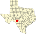
Edwards County | |
---|---|
County | |
Coordinates: 29°58′N100°18′W / 29.97°N 100.3°W | |
Country | United States |
State | Texas |
Founded | 1883 |
Named for | Haden Edwards |
Seat | Rocksprings |
Largest town | Rocksprings |
Area | |
• Total | 2,120 sq mi (5,500 km2) |
• Land | 2,118 sq mi (5,490 km2) |
• Water | 2.0 sq mi (5 km2) 0.09% |
Population (2020) | |
• Total | 1,422 |
• Density | 0.67/sq mi (0.26/km2) |
Time zone | UTC−6 (Central) |
• Summer (DST) | UTC−5 (CDT) |
Congressional district | 23rd |
Website | co |
Edwards County is a county located on the Edwards Plateau in the U.S. state of Texas. As of the 2020 census its population was 1,422. [1] The county seat is Rocksprings. [2] The county was created in 1858 and organized in 1883. [3] It is named for Haden Edwards, [4] an early settler of Nacogdoches, Texas. The Edwards Aquifer and Edwards Plateau are named after the county by reason of their locations. [5]
According to the U.S. Census Bureau the county has a total area of 2,120 square miles (5,500 km2), of which 2,118 square miles (5,490 km2) are land and 2.0 square miles (5.2 km2) (0.09%) are covered by water. [17]
Census | Pop. | Note | %± |
---|---|---|---|
1880 | 266 | — | |
1890 | 1,970 | 640.6% | |
1900 | 3,108 | 57.8% | |
1910 | 3,768 | 21.2% | |
1920 | 2,283 | −39.4% | |
1930 | 2,764 | 21.1% | |
1940 | 2,933 | 6.1% | |
1950 | 2,908 | −0.9% | |
1960 | 2,317 | −20.3% | |
1970 | 2,107 | −9.1% | |
1980 | 2,033 | −3.5% | |
1990 | 2,266 | 11.5% | |
2000 | 2,162 | −4.6% | |
2010 | 2,002 | −7.4% | |
2020 | 1,422 | −29.0% | |
U.S. Decennial Census [18] 1850–2010 [19] 2010 [20] 2020 [21] |
Race / Ethnicity (NH = Non-Hispanic) | Pop 2000 [22] | Pop 2010 [20] | Pop 2020 [21] | % 2000 | % 2010 | % 2020 |
---|---|---|---|---|---|---|
White alone (NH) | 1,161 | 947 | 651 | 53.70% | 47.30% | 45.78% |
Black or African American alone (NH) | 3 | 10 | 2 | 0.14% | 0.50% | 0.14% |
Native American or Alaska Native alone (NH) | 11 | 11 | 5 | 0.51% | 0.55% | 0.35% |
Asian alone (NH) | 1 | 3 | 11 | 0.05% | 0.15% | 0.77% |
Pacific Islander alone (NH) | 0 | 0 | 1 | 0.00% | 0.00% | 0.07% |
Other race alone (NH) | 0 | 0 | 2 | 0.00% | 0.00% | 0.14% |
Mixed race or Multiracial (NH) | 12 | 4 | 32 | 0.56% | 0.20% | 2.25% |
Hispanic or Latino (any race) | 974 | 1,027 | 718 | 45.05% | 51.30% | 50.49% |
Total | 2,162 | 2,002 | 1,422 | 100.00% | 100.00% | 100.00% |
As of the census [23] of 2000, 2,162 people, 801 households, and 586 families resided in the county. The population density was less than 1/km2 (2.6/sq mi). The 1,217 housing units averaged 1/sq mi (0.39/km2). The racial makeup of the county was 83.26% White, 0.79% African American, 0.79% Native American, 0.14% Asian, 12.72% from other races, and 2.31% from two or more races. About 45.05% of the population was Hispanic or Latino of any race.
Of the 801 households, 31.70% had children under the age of 18 living with them, 60.80% were married couples living together, 8.90% had a female householder with no husband present, and 26.80% were not families. About 24.70% of all households were made up of individuals, and 13.50% had someone living alone who was 65 years of age or older. The average household size was 2.66 and the average family size was 3.20.
In the county, the population was distributed as 28.50% under the age of 18, 6.50% from 18 to 24, 23.20% from 25 to 44, 25.70% from 45 to 64, and 16.20% who were 65 years of age or older. The median age was 39 years. For every 100 females, there were 102.60 males. For every 100 females age 18 and over, there were 98.20 males.
The median income for a household in the county was $25,298, and for a family was $27,083. Males had a median income of $21,912 versus $14,907 for females. The per capita income for the county was $12,691. About 24.60% of families and 31.60% of the population were below the poverty line, including 47.40% of those under age 18 and 17.70% of those age 65 or over.
Year | Republican | Democratic | Third party(ies) | |||
---|---|---|---|---|---|---|
No. | % | No. | % | No. | % | |
2024 | 869 | 86.47% | 133 | 13.23% | 3 | 0.30% |
2020 | 893 | 83.77% | 168 | 15.76% | 5 | 0.47% |
2016 | 746 | 69.52% | 303 | 28.24% | 24 | 2.24% |
2012 | 642 | 72.62% | 232 | 26.24% | 10 | 1.13% |
2008 | 673 | 65.02% | 346 | 33.43% | 16 | 1.55% |
2004 | 745 | 77.36% | 217 | 22.53% | 1 | 0.10% |
2000 | 663 | 70.76% | 261 | 27.85% | 13 | 1.39% |
1996 | 511 | 50.44% | 437 | 43.14% | 65 | 6.42% |
1992 | 460 | 51.86% | 254 | 28.64% | 173 | 19.50% |
1988 | 556 | 59.78% | 368 | 39.57% | 6 | 0.65% |
1984 | 626 | 79.64% | 159 | 20.23% | 1 | 0.13% |
1980 | 575 | 69.78% | 237 | 28.76% | 12 | 1.46% |
1976 | 412 | 61.31% | 258 | 38.39% | 2 | 0.30% |
1972 | 520 | 82.02% | 109 | 17.19% | 5 | 0.79% |
1968 | 409 | 64.01% | 148 | 23.16% | 82 | 12.83% |
1964 | 371 | 52.11% | 337 | 47.33% | 4 | 0.56% |
1960 | 463 | 72.46% | 168 | 26.29% | 8 | 1.25% |
1956 | 533 | 79.67% | 133 | 19.88% | 3 | 0.45% |
1952 | 586 | 73.43% | 210 | 26.32% | 2 | 0.25% |
1948 | 185 | 34.32% | 329 | 61.04% | 25 | 4.64% |
1944 | 187 | 31.91% | 348 | 59.39% | 51 | 8.70% |
1940 | 175 | 23.65% | 565 | 76.35% | 0 | 0.00% |
1936 | 157 | 30.54% | 354 | 68.87% | 3 | 0.58% |
1932 | 224 | 27.86% | 575 | 71.52% | 5 | 0.62% |
1928 | 546 | 89.66% | 59 | 9.69% | 4 | 0.66% |
1924 | 346 | 61.35% | 204 | 36.17% | 14 | 2.48% |
1920 | 297 | 56.14% | 201 | 38.00% | 31 | 5.86% |
1916 | 73 | 19.31% | 299 | 79.10% | 6 | 1.59% |
1912 | 114 | 34.86% | 133 | 40.67% | 80 | 24.46% |
School districts include: [25]
The designated community college is Southwest Texas Junior College. [26]
Sutton County is a county located on the Edwards Plateau in the U.S. state of Texas. As of the 2020 census, the population was 3,372. Its county seat is Sonora. The county was created in 1887 and organized in 1890. Sutton County is named for John S. Sutton, an officer in the Confederate Army.
Schleicher County is a county located on the Edwards Plateau in the U.S. state of Texas. As of the 2020 census, its population was 2,451. Its county seat is Eldorado. The county was created in 1887 and organized in 1901. It is named for Gustav Schleicher, a German immigrant who became a surveyor and politician.
San Saba County is a county located on the Edwards Plateau in western Central Texas, United States. As of the 2020 census, its population was 5,730. Its county seat is San Saba. The county is named after the San Saba River, which flows through the county.
San Patricio County is located in the U.S. state of Texas. As of the 2020 census, its population was 68,755. Its county seat is Sinton. San Patricio County is part of the Corpus Christi metropolitan statistical area.
Real County is a county located on the Edwards Plateau in the U.S. state of Texas. As of the 2020 census, its population was 2,758. The county seat is Leakey. The county is named for Julius Real (1860–1944), a former member of the Texas State Senate. The Alto Frio Baptist Encampment is located in an isolated area of Real County southeast of Leakey.
Reagan County is a county on the Edwards Plateau in the U.S. state of Texas. As of the 2020 census, its population was 3,385. The county seat is Big Lake. The county is named after John Henninger Reagan (1818–1905), who was the postmaster general of the Confederate States and also a U.S. senator, U.S. representative, and first chairman of the Railroad Commission of Texas.
Nueces County is located in the U.S. state of Texas. As of the 2020 census, the population was 353,178, making it the 16th-most populous county in the state. The county seat is Corpus Christi. The county was formed in 1846 from portions of San Patricio County and organized the following year. It is named for the Nueces River, which marks the county's northwestern boundary with San Patricio County before emptying into its mouth at Nueces Bay north of the port of Corpus Christi. Nueces County is part of the Corpus Christi metropolitan statistical area.
Nacogdoches County is a county located in the U.S. state of Texas. As of the 2020 census, its population was 64,653. Its county seat is Nacogdoches.
McCulloch County is a county located on the Edwards Plateau in the U.S. state of Texas. At the 2020 census, its population was 7,630. Its county seat is Brady. The county was created in 1856 and later organized in 1876. It is named for Benjamin McCulloch, a famous Texas Ranger and Confederate general.
Mason County is a rural county located on the Edwards Plateau in the U.S. state of Texas. At the 2020 census, its population was 3,953. Its county seat is Mason. The county is named for Fort Mason, which was located in the county.
Lampasas County is a county located on the Edwards Plateau in the U.S. state of Texas. As of the 2020 census, its population was 21,627. Its county seat is Lampasas. The county is named for the Lampasas River.
Kinney County is a county located in the U.S. state of Texas. As of the 2020 census, its population was 3,129. Its county seat is Brackettville. The county was created in 1850 and later organized in 1874. It is named for Henry Lawrence Kinney, an early settler.
Kimble County is a county located on the Edwards Plateau in the U.S. state of Texas. As of the 2020 census, its population was 4,286. Its county seat is Junction. The county was created in 1858 and organized in 1876. It is named for George C. Kimble, who died at the Battle of the Alamo.
Kerr County is a county located on the Edwards Plateau in the U.S. state of Texas. As of the 2020 census, its population was 52,598. Its county seat is Kerrville. The county was named by Joshua D. Brown for his fellow Kentucky native, James Kerr, a congressman of the Republic of Texas. The Kerrville, TX Micropolitan Statistical Area includes all of Kerr County.
Kendall County is a county located on the Edwards Plateau in the U.S. state of Texas. In 2020 census, its population was 44,279. Its county seat is Boerne. The county is named for George Wilkins Kendall, a journalist and Mexican–American War correspondent.
Gillespie County is a county located on the Edwards Plateau in the U.S. state of Texas. As of the 2020 census, its population was 26,725. The county seat is Fredericksburg. It is located in the heart of the rural Texas Hill Country in Central Texas. Gillespie is named for Robert Addison Gillespie, a soldier in the Mexican–American War. It is known as the birthplace of 36th president of the United States of America Lyndon B. Johnson.
Comal County is a county located on the Edwards Plateau in the U.S. state of Texas. As of the 2020 census, its population was 161,501. Comal County is known for its rich German-Texan and European history. Its county seat is New Braunfels.
Coke County is a county located on the Edwards Plateau in the U.S. state of Texas. As of the 2020 census, its population was 3,285. Its county seat is Robert Lee. The county was founded in 1889 and is named for Richard Coke, the 15th governor of Texas and later a U.S. senator. Coke County was one of 46 prohibition, or entirely dry, counties in the State of Texas, but passed a law allowing the sale of beer and wine in 2005.
Bandera County is a county in the U.S. state of Texas. It is located in the Hill Country and its county seat is Bandera. Bandera county was settled by German and Polish emigrants in the mid 1800s. Many residents are descendants of those same emigrants.
Rocksprings is a town in and the county seat of Edwards County, Texas, United States. At the 2020 census, the town population was 874, down from 1,182 at the 2010 census and 1,285 at the 2000 census. The town received its name from natural springs associated with the porous limestone rocks in the area.