Coleman County, Texas

Last updated

Coleman County
Coleman courthouse 2009.jpg
The Coleman County Courthouse in Coleman
Map of Texas highlighting Coleman County.svg
Location within the U.S. state of Texas
Texas in United States.svg
Texas's location within the U.S.
Coordinates: 31°46′N99°27′W / 31.77°N 99.45°W / 31.77; -99.45
CountryFlag of the United States.svg United States
StateFlag of Texas.svg  Texas
Founded1864
Named for Robert M. Coleman
Seat Coleman
Largest cityColeman
Area
  Total1,281 sq mi (3,320 km2)
  Land1,262 sq mi (3,270 km2)
  Water19 sq mi (50 km2)  1.5%
Population
 (2020)
  Total7,684
  Density6.0/sq mi (2.3/km2)
Time zone UTC−6 (Central)
  Summer (DST) UTC−5 (CDT)
Congressional district 11th
Website www.co.coleman.tx.us

Coleman County is a county located in the U.S. state of Texas. As of the 2020 census, its population was 7,684. [1] [2] The county seat is Coleman. [3] The county was founded in 1858 and organized in 1864. [4] It is named for Robert M. Coleman, a signer of the Texas Declaration of Independence and soldier at the Battle of San Jacinto.

Contents

History

Around 10,000 BC, indigenous peoples of the Americas were the first inhabitants. Later inhabitants included the Jumano, Lipan Apache, and Comanche. [5]

In 1632, Father Salas led an expedition to the upper Colorado River. [5] In 1650, Captains Hernán Martín and Diego del Castillo explored the western portion of the county to the Concho River, and returned with pearls. [5] Diego de Guadalajara followed the same path as Martín and Castillo in 1654. [5] From 1683 to 1684, Juan Domínguez de Mendoza established a short-lived Quicuchabe mission. [6]

In 1855, the county's oldest community, Trickham, was founded as a trading post for the ranching activities of John Chisum. [7] Coleman County was formed from Brown and Travis Counties in 1858. The county is named for Robert M. Coleman, a signer of the Texas Declaration of Independence. [5]

In 1861, Rich Coffey settled the communities of Leaday and Voss. [8]

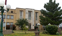
In 1876, the site was chosen for Coleman, the county seat. [9]

The community of Santa Anna was established in 1879. It is named after the Santa Anna Mountains, which in turn, are named after Comanche Chief Santana. [10]

In 1886, the Santa Fe Railway completed a spur to Coleman from nearby Coleman Junction (now San Angelo [11] Junction). [12]

In 1908, the county's first oil well came in near Trickham. [13]

In 1914, the Santa Fe completed the Coleman Cutoff between Coleman, Lubbock, and Clovis. [14] This linked its California lines with the Texas Gulf Coast and put Coleman on the road's main line. Coleman's distinctive [15] brick-and-stucco Santa Fe depot was completed in 1915.

Oil was discovered north of Coleman on the J. P. Morris ranch in 1917. [5]

The Coleman County Medical Center opened in 1923. [5]

By 1925, tenant farmers comprised 63% of local agriculture. [5]

In 1930, the Coleman County population peaked at 23,669. [5]

The Coleman County oilfields produced over a million barrels in 1948. [5]

In 2000, Wind Clean Corporation, harnessing energy from wind power, was founded. [5]

Geography

According to the U.S. Census Bureau, the county has a total area of 1,281 square miles (3,320 km2), of which 1,262 square miles (3,270 km2) are land and 19 square miles (49 km2) (1.5%) are covered by water. [16]

Major highways

Adjacent counties

Demographics

Historical population
CensusPop.Note
1870 347
1880 3,603938.3%
1890 6,11269.6%
1900 10,07764.9%
1910 22,618124.5%
1920 18,805−16.9%
1930 23,66925.9%
1940 20,571−13.1%
1950 15,503−24.6%
1960 12,458−19.6%
1970 10,288−17.4%
1980 10,4391.5%
1990 9,710−7.0%
2000 9,235−4.9%
2010 8,895−3.7%
2020 7,684−13.6%
U.S. Decennial Census [17]
1850–2010 [18] 2010 [19] 2020 [20]
Coleman County, Texas - Demographic Profile
(NH = Non-Hispanic)
Race / EthnicityPop 2010 [19] Pop 2020 [20] % 2010% 2020
White alone (NH)7,1236,01380.08%78.25%
Black or African American alone (NH)1861422.09%1.85%
Native American or Alaska Native alone (NH)40360.45%0.47%
Asian alone (NH)32320.36%0.42%
Pacific Islander alone (NH)100.01%0.00%
Some Other Race alone (NH)4290.04%0.38%
Mixed Race/Multi-Racial (NH)902401.01%3.12%
Hispanic or Latino (any race)1,4191,19215.95%15.51%
Total8,8957,684100.00%100.00%

Note: the US Census treats Hispanic/Latino as an ethnic category. This table excludes Latinos from the racial categories and assigns them to a separate category. Hispanics/Latinos can be of any race.

As of the census [21] of 2000, 9,235 people, 3,889 households, and 2,609 families resided in the county. The population density was 7 people per square mile (2.7 people/km2). The 5,248 housing units averaged 4 units per square mile (1.5/km2). The racial makeup of the county was 88.53% White, 2.19% African American, 0.62% Native American, 0.22% Asian, 0.01% Pacific Islander, 6.53% from other races, and 1.91% from two or more races. About 14% of the population was Hispanic or Latino of any race.

Of the 3,889 households, 27.20% had children under the age of 18 living with them, 53.80% were married couples living together, 9.30% had a female householder with no husband present, and 32.90% were not families; 30.20% of all households were made up of individuals, and 17.40% had someone living alone who was 65 years of age or older. The average household size was 2.33, and the average family size was 2.88.

In the county, the population was distributed as 23.60% under the age of 18, 6.60% from 18 to 24, 22.70% from 25 to 44, 24.00% from 45 to 64, and 23.00% who were 65 years of age or older. The median age was 43 years. For every 100 females, there were 92.20 males. For every 100 females age 18 and over, there were 88.10 males.

The median income for a household in the county was $25,658, and for a family was $31,168. Males had a median income of $25,993 versus $17,378 for females. The per capita income for the county was $14,911. About 15.50% of families and 19.90% of the population were below the poverty line, including 27.40% of those under age 18 and 14.90% of those age 65 or over.

Education

These school districts serve Coleman County:

Communities

Cities

Town

Unincorporated communities

Politics

At the presidential level, Coleman County voted predominantly for the Democratic candidate from 1912 through 1948, with that tendency changing when native son Dwight D. Eisenhower ran successfully in 1952. Thenceforth, GOP candidates have carried the county in most campaigns, with increasingly wide margins in the 21st century.

United States presidential election results for Coleman County, Texas [22]
Year Republican Democratic Third party
No.%No.%No.%
2020 3,64188.18%45110.92%370.90%
2016 3,17787.21%38810.65%782.14%
2012 3,01286.25%44212.66%381.09%
2008 3,01181.33%64317.37%481.30%
2004 3,03579.33%77820.33%130.34%
2000 2,68775.10%85323.84%381.06%
1996 1,79349.19%1,48840.82%3649.99%
1992 1,46235.33%1,57938.16%1,09726.51%
1988 2,34054.15%1,97845.78%30.07%
1984 2,79066.16%1,42033.67%70.17%
1980 2,22855.78%1,71943.04%471.18%
1976 1,66942.20%2,26457.24%220.56%
1972 2,38676.67%72123.17%50.16%
1968 1,50736.68%1,44935.26%1,15328.06%
1964 1,43434.93%2,67065.04%10.02%
1960 2,12753.48%1,83546.14%150.38%
1956 2,24758.50%1,57741.06%170.44%
1952 2,55558.24%1,82441.58%80.18%
1948 54515.89%2,69578.59%1895.51%
1944 49813.44%2,88777.94%3198.61%
1940 45412.19%3,25787.48%120.32%
1936 2698.47%2,90091.28%80.25%
1932 2357.51%2,88192.10%120.38%
1928 1,64553.00%1,45947.00%00.00%
1924 50215.03%2,76382.70%762.27%
1920 35516.03%1,44565.27%41418.70%
1916 964.85%1,70085.86%1849.29%
1912 523.72%1,28091.56%664.72%

See also

Related Research Articles

<span class="mw-page-title-main">Young County, Texas</span> County in Texas, United States

Young County is a county located in the U.S. state of Texas. As of the 2020 census, its population was 17,867. Its county seat is Graham. The county was created in 1856 and organized in 1874. It is named for William Cocke Young, an early Texas settler and soldier.

<span class="mw-page-title-main">Tom Green County, Texas</span> County in Texas, United States

Tom Green County is a county located on the Edwards Plateau in the U.S. state of Texas. As of the 2020 census, its population was 120,003. Its county seat is San Angelo. The county was created in 1874 and organized the following year. It is named for Thomas Green, who was a Confederate soldier and lawyer. Tom Green County is included in the San Angelo metropolitan statistical area; the county is home to Goodfellow Air Force Base, as well as Angelo State University, part of the Texas Tech University System.

<span class="mw-page-title-main">Titus County, Texas</span> County in Texas, United States

Titus County is a county located in the northeastern region of the U.S. state of Texas. As of the 2020 census, its population was 31,247. Its county seat is Mount Pleasant. The county is named for Andrew Jackson Titus, an early settler. Titus County comprises the Mount Pleasant micropolitan statistical area.

<span class="mw-page-title-main">Taylor County, Texas</span> County in Texas, United States

Taylor County is a county located in the U.S. state of Texas. As of the 2020 census, its population was 143,208. Its county seat is Abilene. The county was created in 1858 and later organized in 1878. It is named for Edward Taylor, George Taylor, and James Taylor, three brothers who died at the Battle of the Alamo.

<span class="mw-page-title-main">Swisher County, Texas</span> County in Texas, United States

Swisher County is a county in the U.S. state of Texas. As of the 2020 census, its population was 6,971. Its county seat is Tulia. The county was created in 1876 and later organized in 1890. It is named for James G. Swisher, a soldier of the Texas Revolution and signer of the Texas Declaration of Independence.

<span class="mw-page-title-main">Schleicher County, Texas</span> County in Texas, United States

Schleicher County is a county located on the Edwards Plateau in the U.S. state of Texas. As of the 2020 census, its population was 2,451. Its county seat is Eldorado. The county was created in 1887 and organized in 1901. It is named for Gustav Schleicher, a German immigrant who became a surveyor and politician.

<span class="mw-page-title-main">Reagan County, Texas</span> County in Texas, United States

Reagan County is a county on the Edwards Plateau in the U.S. state of Texas. As of the 2020 census, its population was 3,385. The county seat is Big Lake. The county is named after John Henninger Reagan (1818–1905), who was the postmaster general of the Confederate States and also a U.S. senator, U.S. representative, and first chairman of the Railroad Commission of Texas.

<span class="mw-page-title-main">Panola County, Texas</span> County in Texas, United States

Panola County is a county located in the U.S. state of Texas. As of the 2020 census, its population was 22,491. The county seat is Carthage. Located in East Texas and originally developed for cotton plantations, the county's name is derived from a Choctaw word for cotton.

<span class="mw-page-title-main">Menard County, Texas</span> County in Texas, United States

Menard County is a county located on the Edwards Plateau in the U.S. state of Texas. As of the 2020 census, its population was 1,962. The county seat is Menard. The county was created in 1858 and later organized in 1871. It is named for Michel Branamour Menard, the founder of Galveston, Texas.

<span class="mw-page-title-main">McCulloch County, Texas</span> County in Texas, United States

McCulloch County is a county located on the Edwards Plateau in the U.S. state of Texas. At the 2020 census, its population was 7,630. Its county seat is Brady. The county was created in 1856 and later organized in 1876. It is named for Benjamin McCulloch, a famous Texas Ranger and Confederate general.

<span class="mw-page-title-main">Hunt County, Texas</span> County in Texas, United States

Hunt County is a county in the U.S. state of Texas. As of the 2020 census, its population was 99,956. Its county seat is Greenville. The county is named for Memucan Hunt, Jr., the first Republic of Texas Minister to the United States from 1837 to 1838 and the third Texas Secretary of the Navy from 1838 to 1839. Hunt County is located in Northeast Texas, at the eastern edge of the Dallas/Fort Worth Metroplex and the western edge of East Texas. Hunt County is part of the Dallas-Fort Worth-Arlington metropolitan statistical area.

<span class="mw-page-title-main">Hansford County, Texas</span> County in Texas, United States

Hansford County is a county located in the U.S. state of Texas. As of the 2020 census, its population was 5,285. Its county seat is Spearman. The county was created in 1876 and organized in 1889. It is named for John M. Hansford, a Texas state congressman and judge.

<span class="mw-page-title-main">Hale County, Texas</span> County in Texas, United States

Hale County is a county located in the U.S. state of Texas. As of the 2020 census, its population was 32,522. Its county seat is Plainview. The county was created in 1876 and organized in 1888. It is named for Lt. John C. Hale, a hero of the Battle of San Jacinto. Hale County comprises the Plainview, Texas micropolitan statistical area.

<span class="mw-page-title-main">Fisher County, Texas</span> County in Texas, United States

Fisher County is a county located in the U.S. state of Texas. As of the 2020 census, its population was 3,672. The county seat is Roby. The county was created in 1876 and later organized in 1886. It is named for Samuel Rhoads Fisher, a signer of the Texas Declaration of Independence and a Secretary of the Navy of the Republic of Texas. Fisher County was one of 30 prohibition, or entirely dry, counties in Texas, but is now a fully wet county.

<span class="mw-page-title-main">Concho County, Texas</span> County in Texas, United States

Concho County is a county located on the Edwards Plateau in the U.S. state of Texas. At the 2020 census, the population was 3,303. Its county seat is Paint Rock. The county was founded in 1858 and later organized in 1879. It is named for the Concho River.

<span class="mw-page-title-main">Cherokee County, Texas</span> County in Texas, United States

Cherokee County is a county located in the U.S. state of Texas. As of the 2020 census, its population was 50,412. The county seat is Rusk, which lies 130 miles southeast of Dallas and 160 miles north of Houston. The county was named for the Cherokee, who lived in the area before being expelled in 1839. Cherokee County comprises the Jacksonville micropolitan statistical area, which is also included in the Tyler–Jacksonville combined statistical area.

<span class="mw-page-title-main">Carson County, Texas</span> County in Texas, United States

Carson County is a county located in the U.S. state of Texas. As of the 2020 census, its population was 5,807. The county seat is Panhandle. The county was founded in 1876 and later organized in 1888. It is named for Samuel Price Carson, the first secretary of state of the Republic of Texas.

<span class="mw-page-title-main">Caldwell County, Texas</span> County in Texas, United States

Caldwell County is a county located in the U.S. state of Texas. As of the 2020 census, its population was 45,883. Its county seat is Lockhart. The county was founded in 1848 and named after Mathew Caldwell, a ranger captain who fought in the Battle of Plum Creek against the Comanches and against Santa Anna's armies during the Texas Revolution. Caldwell was also a signer of the Texas Declaration of Independence.

<span class="mw-page-title-main">Santa Anna, Texas</span> Town in Texas, United States

Santa Anna is a town in Coleman County in Central Texas, United States. Its population was 1,099 at the 2010 census.

<span class="mw-page-title-main">Runnels County, Texas</span> County in Texas, United States

Runnels County is a county located in the U.S. state of Texas. As of the 2020 census, its population was 9,900. Its county seat is Ballinger. The county was created in 1858 and later organized in 1880. It is named for Hiram G. Runnels, a Texas state legislator.

References

  1. "U.S. Census Bureau QuickFacts: Coleman County, Texas". United States Census Bureau. Retrieved January 31, 2022.
  2. "Coleman County, Texas". United States Census Bureau . Retrieved February 23, 2021.
  3. "Find a County". National Association of Counties. Archived from the original on May 31, 2011. Retrieved June 7, 2011.
  4. "Texas: Individual County Chronologies". Texas Atlas of Historical County Boundaries. The Newberry Library. 2008. Archived from the original on April 12, 2017. Retrieved May 21, 2015.
  5. 1 2 3 4 5 6 7 8 9 10 11 Tate, Rusty. "Coleman County". Handbook of Texas Online. Texas State Historical Association. Retrieved November 29, 2010.
  6. Hundell, Ken and Sharon (2005). Spirits of the Border V: The History and Mystery of the Lone Star State. Omega Press. p. 176. ISBN   978-0-9626087-9-7.
  7. "Trickham, Texas". Texas Escapes. Texas Escapes - Blueprints For Travel, LLC. Retrieved November 29, 2010.
  8. Lucko, Paul M. "Richard Coffey". Handbook of Texas Online. Texas State Historical Association. Retrieved November 29, 2010.
  9. "Coleman, Texas". Texas Escapes. Texas Escapes - Blueprints For Travel, LLC. Retrieved November 29, 2010.
  10. "Santa Anna, Texas". Texas Escapes. Texas Escapes - Blueprints For Travel, LLC. Retrieved November 29, 2010.
  11. "Coleman Junction". texassantafehistory.com.
  12. Hunt, William R. "Coleman, Texas". tshaonline.org.
  13. Warner, C A; Thompson, Ernest O (2007). Texas Oil & Gas Since 1543. Copano Bay Press. p. 213. ISBN   978-0-9767799-5-7.
  14. Blaszak, Michael W. "ATSF Internet Research Center - Santa Fe: A Chronology". atsfirc.qstation.org.
  15. "Santa Fe Surviving Depots, Osage City, KS and Coleman, TX". atsfrailfan.net.
  16. "2010 Census Gazetteer Files". United States Census Bureau. August 22, 2012. Retrieved April 21, 2015.
  17. "Decennial Census of Population and Housing by Decade". US Census Bureau.
  18. "Texas Almanac: Population History of Counties from 1850–2010" (PDF). Texas Almanac. Archived (PDF) from the original on October 9, 2022. Retrieved April 21, 2015.
  19. 1 2 "P2 HISPANIC OR LATINO, AND NOT HISPANIC OR LATINO BY RACE - 2010: DEC Redistricting Data (PL 94-171) - Coleman County, Texas". United States Census Bureau .
  20. 1 2 "P2 HISPANIC OR LATINO, AND NOT HISPANIC OR LATINO BY RACE - 2020: DEC Redistricting Data (PL 94-171) - Coleman County, Texas". United States Census Bureau .
  21. "U.S. Census website". United States Census Bureau . Retrieved May 14, 2011.
  22. Leip, David. "Dave Leip's Atlas of U.S. Presidential Elections". uselectionatlas.org. Retrieved July 20, 2018.

31°46′N99°27′W / 31.77°N 99.45°W / 31.77; -99.45