Coleman County is a county located in the U.S. state of Texas. As of the 2020 census, its population was 7,684. The county seat is Coleman. The county was founded in 1858 and organized in 1864. It is named for Robert M. Coleman, a signer of the Texas Declaration of Independence and soldier at the Battle of San Jacinto.
The Canadian River is the longest tributary of the Arkansas River in the United States. It is about 1,026 miles (1,651 km) long, starting in Colorado and traveling through New Mexico, the Texas Panhandle, and Oklahoma. The drainage area is about 47,700 square miles (124,000 km2).

The Trinity River is a 710-mile (1,140 km) river, the longest with a watershed entirely within the U.S. state of Texas. It rises in extreme northern Texas, a few miles south of the Red River. The headwaters are separated by the high bluffs on the southern side of the Red River.
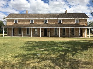
Fort Concho is a former United States Army installation and National Historic Landmark District located in San Angelo, Texas. It was established in November 1867 at the confluence of the North and South Concho Rivers, on the routes of the Butterfield Overland Mail Route and Goodnight–Loving Trail, and was an active military base for the next 22 years. Fort Concho was the principal base of the 4th Cavalry from 1867 to 1875 and then the "Buffalo Soldiers" of the 10th Cavalry from 1875 to 1882. The troops stationed at Fort Concho participated in Ranald S. Mackenzie's 1872 campaign, the Red River War in 1874, and the Victorio Campaign of 1879–1880.

Alonso Álvarez de Pineda was a Spanish conquistador and cartographer who was the first to prove the insularity of the Gulf of Mexico by sailing around its coast. In doing so he created the first map to depict what is now Texas and parts of the Gulf Coast of the United States.
The Little River is a river in Central Texas in the Brazos River watershed. It is formed by the confluence of the Leon River and the Lampasas River near Little River, Texas in Bell County. It flows generally southeast for 75 miles (121 km) until it empties into the Brazos River about 5 miles (8.0 km) southwest of Hearne, at a site called Port Sullivan in Milam County. The Little River has a third tributary, the San Gabriel River, which joins the Little about 8 miles (13 km) north of Rockdale and five miles southwest of Cameron. Cameron, the county seat of Milam County and the only city of any significant size on the Little River, was established in 1846.
Antonio de Espejo was a Spanish explorer who led an expedition, accompanied by Diego Perez de Luxan, into what is now New Mexico and Arizona in 1582–83. The expedition created interest in establishing a Spanish colony among the Pueblo Indians of the Rio Grande valley.

Stiles is a ghost town in Reagan County, Texas, United States, about 18 mi (29 km) north of Big Lake. As the only town in the area when Reagan County was established in 1903, Stiles was made the county seat. Bypassed by the railroad and eclipsed when oil was discovered near Big Lake, Stiles was replaced with Big Lake as the county seat in 1925.

Francisco de Garay was a Spanish Basque conquistador.

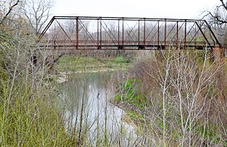
The North Concho River is a river in west-central Texas and one of three tributaries of the Concho River. The river is 88 miles (142 km) long. The other two tributaries are the Middle Concho and South Concho Rivers. The Concho River flows into the Colorado River.

The North Fork Red River, sometimes called simply the "North Fork", is a tributary of the Red River of the South about 271 mi (436 km) long, heading along the eastern Caprock Escarpment of the Llano Estacado about 11.4 mi (18.3 km) southwest of Pampa, Texas. Rising in Gray County, Texas, it terminates at the confluence with Prairie Dog Town Fork of the Red River at the Texas-Oklahoma border.

The Jumanos were a tribe or several tribes, who inhabited a large area of western Texas, New Mexico, and northern Mexico, especially near the Junta de los Rios region with its large settled Indigenous population. They lived in the Big Bend area in the mountain and basin region. Spanish explorers first recorded encounters with the Jumano in 1581. Later expeditions noted them in a broad area of the Southwest and the Southern Plains.
Don Pedro de Rábago y Terán was a Spanish administrator and military officer in New Spain. He was governor of Coahuila from August 1744 to June 1754. In 1754, Don Pedro de Rábago y Terán was sent by the viceroy of New Spain to find a site for an Apache Mission, named a pass between the hills in Menard County overlooking the San Saba River as Puerto de Baluartes. The Santa Cruz de San Sabá Mission was established three years later on the San Saba River near Menard, Texas. As an explorer in the late 1740s he went on three expeditions to the confluence of the Rio Grande and the Rio Conchos, known as La Junta de los Rios, in order to establish a presidio or military camp to serve six missions in the area of La Junta, which were being attacked by the Apache. He recommended a site that became the Presidio de la Junta de los Ríos Norte y Conchos near what is now Presidio, Texas.
Hernando de Ugarte y la Concha was Governor of New Mexico from 1649 to 1653.
The Diego de Guadalajara expedition of 1654 was a Spanish expedition dispatched to follow up on the finding of freshwater pearls from pearl mussels in the Concho River in what is now Texas. Although results were disappointing, the expedition led to continued contact with the people of the area and then to Spanish settlement in and around San Angelo, Texas.
Alonso del Castillo Maldonado was an early Spanish explorer in the Americas. He was one of the last four survivors of the original members of the 1527 Narváez expedition, along with Álvar Núñez Cabeza de Vaca, Andrés Dorantes de Carranza and his African slave Estevanico. They were the early non-native people to travel and be enslaved in the Southwest region of the modern United States. Castillo Maldonado lived with a Native American tribe in Texas in 1527 and 1528.
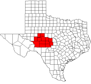
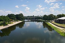
The Concho Valley is a region in West Texas. The region takes its name from the Concho River, named due to its abundance of freshwater mussels in the river.

Quitaque Creek is an intermittent stream about 40 mi (64 km) long, originating as a shallow draw on the high plains of the Llano Estacado in Floyd County, Texas, and flowing eastward to join the North Pease River in Motley County, Texas.

Cyrtonaias tampicoensis is a freshwater bivalve mollusc belonging to the family Unionidae.