Oso Bay

Last updated
Ward Island with Oso Bay in the background TAMUCC island.jpg
Ward Island with Oso Bay in the background
Oso Bay Oso bay, from SPID.jpg
Oso Bay
Skimmer Key Skimmer Key.jpg
Skimmer Key

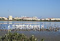
Oso Bay is a bay bordered by Corpus Christi, Texas. The bay is fed freshwater by Oso Creek and saltwater from Corpus Christi Bay. The Hans and Pat Suter Wildlife Refuge is located on the bay's western shore near the Pharaoh Valley subdivision, Naval Air Station Corpus Christi is located on its eastern shore in Flour Bluff, newly created Skimmer Key is located between the Oso Bay Bridge and the Naval Air Station, and Texas A&M University - Corpus Christi on Ward Island is located on the northern shore of Oso Bay. On the bay’s southwestern shore is the Oso Bay Wetlands Preserve.

Contents

Location

Oso Bay is located at 27°41′30″N97°18′40″W / 27.69167°N 97.31111°W / 27.69167; -97.31111 .

Recreation

Oso Bay's sea floor consists of mostly mud, ooze, and oyster reefs, which is discouraging for swimming. The depth of the main bay and an old, abandoned railroad structure along with the abundance of oysters and vegetation promote fishing. Birding and hiking are popular activities along the wildlife refuge on the North shore of Oso Bay. Boating, kayaking, and kite surfing are also some attractions to Oso Bay.

Fishing

Surf fishing, or wade fishing, is a popular activity in Oso Bay due to its shallow depth. Species of fish in Oso Bay include

Live Shrimp and artificial lures are commonly used for fishing in the area.

Birding

Oso Bay is home to the Hans and Pat Suter Wildlife Refuge which is considered to be one of the best sea bird watching areas in the world. Some of the birds regularly found in the on and around Oso Bay are

Related Research Articles

<span class="mw-page-title-main">Corpus Christi, Texas</span> City in Texas, United States

Corpus Christi is a coastal city in the South Texas region of the U.S. state of Texas and the county seat and largest city of Nueces County. Portions of the city also extend into Aransas, Kleberg, and San Patricio counties. It is 130 miles (210 km) southeast of San Antonio and 208 miles (335 km) southwest of Houston. Its political boundaries encompass Nueces Bay and Corpus Christi Bay. Its zoned boundaries include small land parcels or water inlets of three neighboring counties.

<span class="mw-page-title-main">Sabine Lake</span> Estuary on the Texas–Louisiana border

Sabine Lake is a bay on the Gulf coasts of Texas and Louisiana, located approximately 90 miles (140 km) east of Houston and 160 miles (260 km) west of Baton Rouge, adjoining the city of Port Arthur. The lake is formed by the confluence of the Neches and Sabine Rivers and connects to the Gulf of Mexico through Sabine Pass. It forms part of the Texas–Louisiana border, falling within Jefferson and Orange Counties in Texas and Cameron Parish, Louisiana.

<span class="mw-page-title-main">Matagorda Bay</span> Bay on the Texas coast, United States of America

Matagorda Bay is a large Gulf of Mexico bay on the Texas coast, lying in Calhoun and Matagorda counties and located approximately 80 miles (130 km) northeast of Corpus Christi, 143 miles (230 km) east-southeast of San Antonio, 108 miles (174 km) south-southwest of Houston, and 167 miles (269 km) south-southeast of Austin. It is one of seven major estuaries along the Gulf Coast of Texas and serves as the mouth of numerous streams, most notably the Lavaca and Colorado Rivers. The Texas seaport of Port Lavaca is located on the system's northwestern extension of Lavaca Bay. The city of Palacios is found on northeastern extension of Tres Palacios Bay, and Port O'Connor is located on the southwestern tip of the main bay's shore. The ghost town of Indianola, which was a major port before it was destroyed by two hurricanes in the late 19th century, is also found on the bay.

<span class="mw-page-title-main">Aransas Bay</span> Bay on the Gulf Coast in Texas, United States

Aransas Bay is a bay on the Texas Gulf Coast, approximately 30 miles (48 km) northeast of Corpus Christi, and 173 miles (278 km) south of San Antonio. It is separated from the Gulf of Mexico by San José Island. Aransas Pass is the most direct navigable outlet into the Gulf of Mexico from the bay. The cities of Aransas Pass and Port Aransas are located at the southern end, and Rockport is found on the central western shore. The bay is oriented laterally northeast–southwest, and is extended by Redfish Bay to the southwest, Copano Bay to the west, Saint Charles Bay to the north, and Mesquite Bay to the northeast. Aransas Bay is part of the Mission-Aransas National Estuarine Research Reserve.

<span class="mw-page-title-main">Corpus Christi Bay</span> Estuary bay on the Texas coast

Corpus Christi Bay is a scenic semi-tropical bay on the Texas coast found in San Patricio and Nueces counties, next to the major city of Corpus Christi. It is separated from the Gulf of Mexico by Mustang Island, and is fed by the Nueces River and Oso Creek from its western and southern extensions, Nueces Bay and Oso Bay. The bay is located approximately 136 miles (219 km) south of San Antonio, and 179 miles (288 km) southwest of Houston.

<span class="mw-page-title-main">Hans and Pat Suter Wildlife Refuge</span>

The Hans and Pat Suter Wildlife Refuge is a wildlife refuge in Corpus Christi, Texas. The Refuge is located on the western shore of Oso Bay, on Ennis Joslin Road, near the Pharaoh Valley subdivision.

<span class="mw-page-title-main">San Antonio Bay</span> Estuary bay on the Texas coast

San Antonio Bay is a bay on the Texas Gulf Coast situated between Matagorda and Aransas Bay. It consists mainly of the combined waters of the San Antonio and Guadalupe rivers, and is located at the mouth of the Guadalupe River, about 55 miles (89 km) northeast of Corpus Christi and 130 miles (209 km) southeast of San Antonio. It is protected from the Gulf of Mexico by Matagorda Island, leaving only relatively small and distant outlets to the Gulf for little mixing of bay and Gulf waters. The remoteness of the bay has prevented the establishment of major ports as seen on Aransas Bay and Corpus Christi Bay, to the south.

<span class="mw-page-title-main">South Texas Botanical Gardens & Nature Center</span>

The South Texas Botanical Gardens & Nature Center, formerly known as the Corpus Christi Botanical Gardens and Nature Center is a nonprofit, 180-acre botanical garden and nature center located at 8545 South Staples, Corpus Christi, Texas. It is open daily; an admission fee is charged.

<span class="mw-page-title-main">Texas State Aquarium</span> Aquarium in Texas, United States

The Texas State Aquarium is a nonprofit aquarium located in Corpus Christi, Texas, United States. It aims to promote environmental conservation and rehabilitation of the wildlife of the Gulf of Mexico. It has been accredited by the Association of Zoos and Aquariums (AZA) since 1995. It is the largest aquarium in Texas and one of the largest aquaria in the United States.

<span class="mw-page-title-main">Ward Island (Texas)</span> Island in the US state of Texas

Ward Island is a small body of land situated at the confluence of Corpus Christi Bay and Oso Bay and is part of the city of Corpus Christi, Texas. Most of Ward Island is now used by Texas A&M University-Corpus Christi.

<span class="mw-page-title-main">Copano Bay</span> Bay in Texas on the Gulf of Mexico fed by the two rivers and a creek

Copano Bay is a northwestern extension of Aransas Bay, west of Rockport, Texas in Refugio and Aransas counties. It is supplied with seawater from the Gulf of Mexico via Aransas Bay, and fed freshwater from the Aransas River, Mission River and Copano Creek. As an estuary, the bay is home to a diverse ecosystem consisting of various birds including the endangered whooping crane, and numerous finfish including the redfish as well as shellfish such as oysters. It is classified as a nursery for shrimp, which prohibits production from the bay. Copano Bay is also a historic location for human usage and settlement that dates back to the 18th century, beginning with the historic port of El Copano and the 19th century settlements of St. Mary's of Aransas and Copano. The present-day towns of Bayside, Copano Village and Holiday Beach were all founded in the 20th century. Oil and natural gas are pumped from below the bay's surface, and contribute to the livelihood of the local economies. Recently, areas around the bay were affected by Hurricane Harvey which crossed over the bay as a Category 3 hurricane.

<span class="mw-page-title-main">Nueces Bay</span> Bay in Texas, United States

Nueces Bay is a northwestern extension of Corpus Christi Bay in the San Patricio and Nueces Counties of Texas. The bay is fed by the Nueces River, forming a natural estuary, which renders it ecologically and economically vital to the surrounding area. It serves as a habitat for the propagation of fish and shellfish, which sustain diverse species of birds and other wildlife. The bay is threatened by pollution from the heavy industry on its southern shore, which prevents oyster farming. Petrochemical production and oil are important to the surrounding economies of the major settlements of Corpus Christi and Portland, found on the eastern shore and connected by the Nueces Bay Causeway at the bay's confluence with Corpus Christi Bay.

Flour Bluff is a specified area of the city of Corpus Christi, Texas. It is located on Encinal peninsula bordered by Corpus Christi Bay on the north, Oso Bay on the west, the Laguna Madre on the east and the King Ranch to the south. South Padre Island Drive crosses Flour Bluff, dividing it into an upper part, commonly known as North Bluff,, and a lower part, commonly known as South Bluff. The area is mostly made up of suburban development, with a population consisting mostly of lower-middle income families, with local and national businesses such as Walmart, H-E-B grocery stores, etc.

<span class="mw-page-title-main">Great Texas Coastal Birding Trail</span> Birdwatching trail system along the length of the Texas Gulf Coast

The Great Texas Coastal Birding Trail is a state-designated system of trails, bird sanctuaries, and nature preserves along the entire length of the Texas Gulf Coast in the United States. As the state of Texas hosts more bird species than any other state in the U.S. the trail system offers some of the most unusual opportunities for bird-watching in the world. The "trail" is actually 43 separate hiking and driving trails that include 308 birding sites. The sites themselves feature a variety of viewing opportunities with boardwalks, observation decks, and other amenities. The trails boast more than 450 bird species. The trail system is managed by the Texas Parks and Wildlife Department as part of the Great Texas Wildlife Trails which also include the Heart of Texas Wildlife Trail, the Panhandle Plains Wildlife Trail, and the Prairies and Pineywoods Wildlife Trail.

<span class="mw-page-title-main">Redfish Bay</span> Bay

Redfish Bay is a southwestern extension of Aransas Bay in Texas, north of Corpus Christi Bay. It separates the cities of Aransas Pass and Ingleside from Port Aransas on Mustang Island.

St. Charles Bay is an inlet of Aransas Bay in Aransas County, Texas. It is flanked by Lamar peninsula on the west and Blackjack peninsula on the east. The bay hosts a valued ecosystem for the endangered whooping crane, and is a prime location for birding and fishing. Goose Island State Park and the Aransas National Wildlife Refuge are located along the bay's shores, attracting nature enthusiasts year-round.

<span class="mw-page-title-main">Laguna Madre (United States)</span> Hypersaline lagoon in Texas, US

The Laguna Madre is a long, shallow, hypersaline lagoon along the western coast of the Gulf of Mexico in Nueces, Kenedy, Kleberg, Willacy and Cameron Counties in Texas, United States. It is one of seven major estuaries along the Gulf Coast of Texas. The roughly 20-mile (32 km) long Saltillo Flats land bridge divides it into Upper and Lower lagoons joined by the Intracoastal Waterway, which has been dredged through the lagoon. Cumulatively, Laguna Madre is approximately 130 miles (210 km) long, the length of Padre Island in the US. The main extensions include Baffin Bay in Upper Laguna Madre, Red Fish Bay just below the Saltillo Flats, and South Bay near the Mexican border. As a natural ecological unit, the Laguna Madre of the United States is the northern half of the ecosystem as a whole, which extends into Tamaulipas, Mexico approximately 144 miles (232 km) south of the US border, to the vicinity of the Rio Soto La Marina and the town of La Pesca, extending approximately 275 miles (443 km) through USA and Mexico in total.

<span class="mw-page-title-main">Estuaries of Texas</span> Estuaries on the Gulf coast of Texas

The U.S. state of Texas has a series of estuaries along its coast on the Gulf of Mexico, most of them bounded by the Texas barrier islands. Estuaries are coastal bodies of water in which freshwater from rivers mixes with saltwater from the sea. Twenty-one drainage basins terminate along the Texas coastline, forming a chain of seven major and five minor estuaries: listed from southwest to northeast, these are the Rio Grande Estuary, Laguna Madre, the Nueces Estuary, the Mission–Aransas Estuary, the Guadalupe Estuary, the Colorado–Lavaca Estuary, East Matagorda Bay, the San Bernard River and Cedar Lakes Estuary, the Brazos River Estuary, Christmas Bay, the Trinity–San Jacinto Estuary, and the Sabine–Neches Estuary. Each estuary is named for its one or two chief contributing rivers, excepting Laguna Madre, East Matagorda Bay, and Christmas Bay, which have no major river sources. The estuaries are also sometimes referred to by the names of their respective primary or central water bodies, though each also includes smaller secondary bays, inlets, or other marginal water bodies.

References