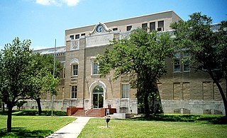
San Patricio County is located in the U.S. state of Texas. As of the 2020 census, its population was 68,755. Its county seat is Sinton. San Patricio County is part of the Corpus Christi metropolitan statistical area.

Nueces County is located in the U.S. state of Texas. As of the 2020 census, the population was 353,178, making it the 16th-most populous county in the state. The county seat is Corpus Christi. The county was formed in 1846 from portions of San Patricio County and organized the following year. It is named for the Nueces River, which marks the county's northwestern boundary with San Patricio County before emptying into its mouth at Nueces Bay north of the port of Corpus Christi. Nueces County is part of the Corpus Christi metropolitan statistical area.

Kingsville is a city in the southern region of the U.S. state of Texas and the county seat of Kleberg County. Located on the U.S. Route 77 corridor between Corpus Christi and Harlingen, Kingsville is the principal city of the Kingsville Micropolitan Statistical Area, which is part of the larger Corpus Christi-Kingsville Combined Statistical Area. The population was 25,402 at the 2020 census, and in 2022 the U.S. Census Bureau estimated the population at 24,833.
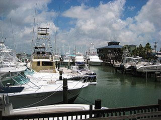
Port Aransas is a city in Nueces County, Texas, United States. This city is 180 miles southeast of San Antonio. The population was 2,904 at the 2020 census. Port Aransas is the only established town on Mustang Island. It is located north of Padre Island and is one of the longest barrier islands along the Texas coast. Corpus Christi Bay, the Gulf of Mexico, the Lydia Ann Ship Channel, and the Corpus Christi Ship Channel make up the surrounding waters.
Mathis is a city in San Patricio County, Texas, United States. The population was 4,333 at the 2020 census.

Corpus Christi is a coastal city in the South Texas region of the U.S. state of Texas and the county seat and largest city of Nueces County with portions extending into Aransas, Kleberg, and San Patricio counties. It is 130 miles (210 km) southeast of San Antonio and 208 miles (335 km) southwest of Houston. Its political boundaries encompass Nueces Bay and Corpus Christi Bay. Its zoned boundaries include small land parcels or water inlets of three neighboring counties.
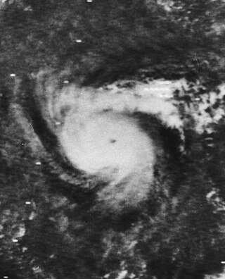
Hurricane Celia was the costliest tropical cyclone in Texas history until Hurricane Alicia in 1983. The third named storm, second hurricane, and first major hurricane of the 1970 Atlantic hurricane season, Celia developed from a tropical wave in the western Caribbean Sea on July 31. Initially, the depression tracked north-northwestward, crossing over western Cuba on August 1 and becoming Tropical Storm Celia. Heavy rains on the island caused severe flooding, leading to five fatalities. The storm entered the Gulf of Mexico, and due to the warm sea surface temperatures, Celia intensified into a hurricane later that day. Storm surge and swells lashed the west coast of Florida, especially the Panhandle, causing eight people to drown. On August 2 and early on August 3, Celia slightly weakened, however, the storm underwent rapid intensification and deepening, and peaked as a Category 4 hurricane at landfall with winds of 140 mph (220 km/h) later on August 3.

South Texas is a geographic and cultural region of the U.S. state of Texas that lies roughly south of—and includes—San Antonio. The southern and western boundary is the Rio Grande, and to the east it is the Gulf of Mexico. The population of this region is more than 5 million according to the 2024 census estimates. The southern portion of this region is often referred to as the Rio Grande Valley. The eastern portion along the Gulf of Mexico is also referred to as the Coastal Bend.

The Nueces Hotel in Corpus Christi, Texas, was a luxury hotel that also served the city as a center of social and political life during the early 20th century and was for years the largest building in Texas south of San Antonio.

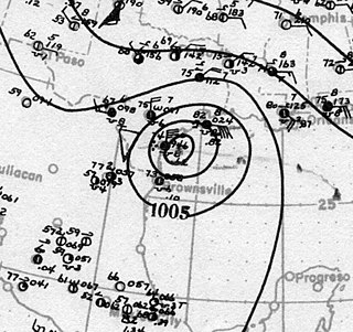
Hurricane Bret was the first of five Category 4 hurricanes that developed during the 1999 Atlantic hurricane season and the first tropical cyclone since Hurricane Jerry in 1989 to make landfall in Texas at hurricane intensity. Forming from a tropical wave on August 18, Bret slowly organized within weak steering currents in the Bay of Campeche. By August 20, the storm began to track northward and underwent rapid intensification on August 21. After this period of strengthening, Bret attained its peak intensity with winds of 145 miles per hour (233 km/h) and a barometric pressure of 944 mbar (hPa; 27.9 inHg). Later that day, the storm weakened to a Category 3 hurricane and made landfall on Padre Island, Texas. Shortly thereafter, the storm weakened further, becoming a tropical depression 24 hours after moving inland. The remnants of the storm eventually dissipated early on August 26 over northern Mexico.

Corpus Christi Bay is a scenic semi-tropical bay on the Texas coast found in San Patricio and Nueces counties, next to the major city of Corpus Christi. It is separated from the Gulf of Mexico by Mustang Island, and is fed by the Nueces River and Oso Creek from its western and southern extensions, Nueces Bay and Oso Bay. The bay is located approximately 136 miles (219 km) south of San Antonio, and 179 miles (288 km) southwest of Houston.
Old Bayview Cemetery is a cemetery located on a small hill in downtown Corpus Christi, Texas, on Ramirez St. at Padre St., bordered by the I-37 access road. It is the oldest federal military cemetery in Texas. Owned by the City of Corpus Christi, it presently comprises three and a half acres as a Historic Texas Cemetery and a State Archaeological Landmark of the Texas Historical Commission. The cemetery was listed on the National Register of Historic Places in 2020.
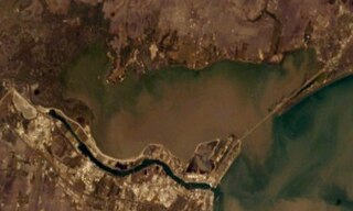
Nueces Bay is a northwestern extension of Corpus Christi Bay in the San Patricio and Nueces Counties of Texas. The bay is fed by the Nueces River, forming a natural estuary, which renders it ecologically and economically vital to the surrounding area. It serves as a habitat for the propagation of fish and shellfish, which sustain diverse species of birds and other wildlife. The bay is threatened by pollution from the heavy industry on its southern shore, which prevents oyster farming. Petrochemical production and oil are important to the surrounding economies of the major settlements of Corpus Christi and Portland, found on the eastern shore and connected by the Nueces Bay Causeway at the bay's confluence with Corpus Christi Bay.
Calallen is a former town that existed until the 1960s. Today, Calallen is an outlying portion of the larger city of Corpus Christi. It is located in Nueces County, in the Coastal Bend region of Texas. It is bound to the north by the Nueces River, which also marks the boundary between Nueces County and San Patricio County.

Henry Lawrence Kinney was an American politician, military officer, and later filibuster known for founding what became the city of Corpus Christi, Texas. Born in Pennsylvania, Kinney moved to Texas in 1838 and settled near present-day Brownsville. He served in both houses of the Texas Legislature. He was killed in a gunfight in Mexico in 1862. Kinney County, Texas is named for him.
The Port of Corpus Christi is the third-largest port in the United States in total waterborne tonnage, largest crude oil export gateway in the nation, second in the United States in LNG exports and the third-largest gateway in the world for crude oil exports. The Port of Corpus Christi is located on Corpus Christi Bay in the western Gulf of Mexico, with a 36-mile channel that is being widened and deepened to 54 feet MLLW from its current depth of 45 feet.

Rose Meza Harrison is a Democratic politician and Democratic nominee for U.S. Representative in the 27th Congressional District of Texas.
The following is a timeline of the history of the city of Corpus Christi, Texas, USA.
The effects of the 1919 Florida Keys hurricane in Texas were the deadliest of any tropical cyclone in the Texas Coastal Bend, killing at least 284 people. The hurricane produced a widespread swath of devastation across the region, exacerbated by the large extent of its winds. The city of Corpus Christi bore the brunt of the hurricane's impacts, contributing to the largest portion of the damage toll in Texas; nearly all of the confirmed fatalities were residents of the city. The storm originated from the Leeward Islands early in September 1919 and took a generally west-northwestward course, devastating the Florida Keys en route to the Gulf of Mexico. On the afternoon of September 14, the center of the hurricane made landfall upon the Texas coast at Baffin Bay. The storm's winds were estimated at 115 mph (185 km/h) at landfall, making it a Category 3 hurricane on the Saffir–Simpson hurricane wind scale. After slowly moving ashore, it weakened and straddled the Rio Grande before dissipating on September 16 over West Texas.

Hurricane Hanna was the first of a record-tying six Atlantic hurricanes to make landfall in the United States in one year. The eighth named storm and first hurricane of the extremely active 2020 Atlantic hurricane season, Hanna developed from a tropical wave originating near Hispaniola. This disturbance dropped heavy rain upon parts of Hispaniola, Cuba, and Florida. The wave gradually became more organized and developed into a tropical depression in the central portion of the Gulf of Mexico. The depression strengthened into a tropical storm on July 24, setting a new record for the earliest eighth-named storm in the basin, getting its name 10 calendar days before the previous record holder, Tropical Storm Harvey of 2005. Hanna steadily intensified as it drifted toward Southern Texas, becoming the season's first hurricane early on July 25. It then began to quickly strengthen just before making landfall at 22:00 UTC later that day as a high-end Category 1 hurricane, with maximum sustained winds of 90 mph (140 km/h) and a minimum central pressure of 973 mbar. Hanna weakened quickly as it moved inland and turned west-southwest, eventually dissipating over Mexico on July 26.
