Tropical Storm Amelia was a weak but catastrophic tropical storm that was the second-wettest tropical cyclone on record in the continental United States. Amelia developed from a tropical wave that moved through the Atlantic Ocean uneventfully. The disturbance then entered an area of the Gulf of Mexico that was conducive to tropical cyclogenesis and became the first tropical depression of the season,after which it was forecast to make landfall before any significant intensification. However,the tropical depression defied predictions,quickly strengthening into a weak tropical storm just hours before making landfall in Corpus Christi. The storm lasted roughly a day over land before becoming unidentifiable after being active for just under 48hours. After dissipating,the storm caused a severe flooding disaster in Texas.
Amelia affected the Texas coast for two days which caused several shipping incidents and minor damage in Corpus Christi and South Padre Island. While active,there were no deaths linked to the storm. However,the biggest impact from the storm followed its dissipation,when its remnants contributed to record rainfall totals over the state. The state,already suffering from a previous drought,believed that the rain would help alleviate the conditions. However,the dry ground aided the flooding from the storm. The rainfall caused several rivers and creeks to flood,especially around the Texas Hill Country and northern Texas,leading to severe damage. Following the storm,PresidentJimmy Carter declared six counties in the state as federal disaster areas,allowing residents to seek aid from the government. Additional aid was brought in from as far away as New York. Overall,Amelia caused 33fatalities with an estimated $110million in damages in what then-governorDolph Briscoe called one of the worst floods in the history of the state.
Meteorological history
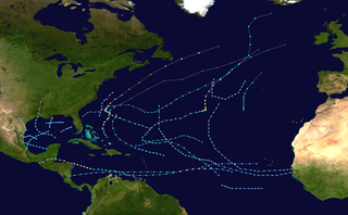
Map plotting the storm's track and intensity,according to the Saffir–Simpson scale
A tropical wave moved off the African coast on July 19. The system headed westward through the Atlantic Ocean for the next week with no change in development. After entering the Caribbean Sea on July 26, convection began to come together two days later due to the influence of anticyclonic flow.[1][2] The disturbance passed the Yucatan Peninsula on July 29 and entered the Gulf of Mexico. No circulation was found in the developing system, however.[1]
On July 30, the disturbance turned to the northwest and entered an area of the Gulf with slightly above normal sea surface temperatures and low vertical wind shear, which favored further development.[3][4] At this point, the presentation seen on satellite imagery had indicated that a tropical cyclone was beginning to form in the Gulf. After a reconnaissance aircraft went into the system, the cyclone was upgraded into the first tropical depression of the season that afternoon while 30 miles (48km) south of Brownsville, Texas. When it formed, it was moving north-northwest at 12mph (19km/h), which was thought at the time to inhibit further strengthening due to the depression moving onto land.[5] Several hours later, the depression was upgraded to Tropical Storm Amelia, a decision that one forecaster said was made to be on the safe side.[6] Amelia peaked at 50mph (80km/h) in wind speed when it was upgraded, with the system beginning to skirt the Texas coast.[1] At peak intensity, the storm had gale-force winds along a diameter of 150 miles (240km).[6]
Amelia, which never had a well-defined center, went up the coast during the afternoon and evening of July 30, making landfall in Corpus Christi the next day. The system was tracked until passing just west of San Antonio, where it became indiscernible after the morning of August 1.[1] The storm was active for a short span of time — just under two days — forming and dissipating so quickly that, following the storm, there was some controversy about the reliability of the weather forecasters.[7]
Preparations
While the storm was over water, small craft advisories were issued by the Coast Guard in addition to cautioning people on vacation in South Padre Island to avoid the beaches.[8] However, as it was a Sunday evening, most of the ships were already coming into port.[7] As Amelia approached the Texas coast, gale warnings were issued for the area from Brownsville to Port O'Connor on July 30.[9] Due to it forming in close proximity to the coast, warnings were issued as soon as the storm was named.[10] As the state had been in the midst of a severe drought the previous six weeks, there was hope that Amelia would relieve the dry conditions.[11] However, the drought conditions would benefit the floods from the storm due to the ground being rendered so dry that it was unable to soak up all the rain from the storm.[12][13]
Impact
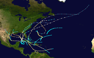
The remnants of Amelia on August 3.
Effects from Amelia as a tropical cyclone ranged from 38 miles per hour (61km/h) winds in Brownsville to gusts of up to 58 miles per hour (93km/h) in Corpus Christi. Inland Texas fared much worse, though. The continuous flow of tropical moisture during Amelia's dissipation and remnant stage brought heavy flooding for two to three days, putting 25counties under flash flood warnings.[14] The orographic effect of the Edwards Plateau enhanced the flooding, leading to rainfall totals as high as 48 inches (1,200mm) in a two-day period.[15] Although the showers stretched into Dallas, Oklahoma, and Arkansas, any damages from the storm in these areas are unknown.[16] The final toll from the storm was 33dead, most of which occurred a week after the storm made landfall, and $110million in damage.[17][18] Most of the damage was located in two specific areas: an area consisting of the towns of Albany and Graham, and the Texas Hill Country, although light flooding was reported elsewhere.[19]
Gulf of Mexico and the Texas Coast
In coastal areas of Texas, damage was limited to the sinking of several shrimp boats and the beaching of sail boats. One ship — the Mermaid of the Sea— was caught in the middle of the storm.[8] Although it sank, its crew was rescued.[20] A pleasure boat with three occupants and the two-man crew of a beached catamaran were all reported missing, but were later found.[7][20] Three other people on board a fishing vessel were treated for exposure.[7] Rescue ships were hampered by anchored Mexican boats and surfers in a channel near the Coast Guard station.[21] According to the Coast Guard, all nine ships that had been reported missing in the storm were later accounted for.[22] Along with the ships, an oil drilling rig in the Gulf was ripped from its location and ran aground near Matagorda Island by the storm. The 19crew members of the rig were rescued by helicopter. As the rig had not yet begun drilling, there was no threat from an oil spill.[7]
In Port Isabel, there was some flooding on the southeast part of the town which was alleviated when some of the manhole covers were opened. In addition, a tornado was thought to have touched down, causing minor damage.[23] South Padre Island reported power outages after receiving over 4 inches (100mm) of rain and the Queen Isabella Causeway was rendered nearly impassable due to rainfall.[24] During its time as a tropical cyclone, there were no deaths linked to Amelia.[20]
Northern Texas
The town of Albany was hit hard when the town drainage system and Hubbard Creek both flooded. The ensuing torrent destroyed 25–30houses and a dozen businesses and damaged hundreds more while inundating 80% of the town. In addition, all incoming roads were flooded, the pavement on U.S. Route 283 was washed away, and a bridge on U.S. Route 180 buckled, preventing anyone from entering or leaving on land. The town's water supply was contaminated and the electricity and communications were also knocked out.[25][26][27][28] The death toll from Albany was set at nine dead and twelve missing, although the town sheriff said that four people who were missing would likely never be found due to several cave-ins along the creek, possibly burying them up to 20 feet (6.1m) deep in mud.[14][29] Rescue efforts here were hampered by overflowing creeks and a lack of communication.[30] The rain was also responsible for carving a 50 feet (15m) deep hole in an earthen dam at nearby Lake Throckmorton, but the water from the dam was safely taken up by a nearby creek. The town of Throckmorton itself was completely evacuated and, like Albany, had its fresh water supply contaminated.[28][31]
North of Albany, the Brazos River also flooded, with the Clear Fork Brazos River becoming 2 miles (3.2km) wide at one point, despite normally being a dry creek bed.[25] The Brazos overflowing, in addition to the flooding of the nearby Salt Creek, resulted in the west side of Graham — the county seat of Young County where flood victims from Eliasville and South Bend had taken shelter — becoming flooded over to within blocks of the Young County Courthouse. Later, the flood waters were reported to have entered the basement of the courthouse.[29][32] Effects from the flooding in Graham ranged from 150houses and 40–50businesses being inundated to the loss of water and electrical utilities. No fatalities were reported, however, due to the water levels rising gradually, leaving time for residents to evacuate.[33][34] The crest of the Brazos flood then headed for the Possum Kingdom Lake with a threat of lowland flooding, resulting in evacuations of riverside towns in Parker and Palo Pinto counties, although a report from Palo Pinto said that no flooding was expected.[35] The flooding was alleviated at the Possum Kingdom Lake, as the lake was already down 6 feet (1.8m) from normal and some of the floodgates there were opened, taking most of the water from the flood.[36] Elm Creek, near Abilene, also swelled, flooding into the town, but the only reported damage there was street flooding.[37][38] An additional death was reported in the town of Morse.[26]
Southern Texas
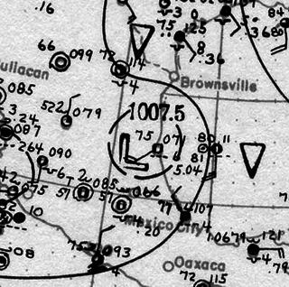
Amelia's Rainfall Totals in Texas
The hardest hit area during the storm was the Guadalupe River basin and its tributaries. A sign of the oncoming problem was a wall of water witnessed cascading down the Leona River in Uvalde.[12] Like with Graham, Uvalde was ultimately flooded up to a block away from the courthouse.[39] The Guadalupe River became heavily flooded, rising 10 feet (3.0m) in one hour. The rapid rise covered a bridge on U.S. Route 281, 40 miles (64km) north of San Antonio and prompted evacuations in a 20 miles (32km) area near the flood plains.[40][41] The overflowing river was responsible for ten total deaths in Kendall and Kerr Counties and submerging Comfort under seven feet of water, killing four people there. The towns of Welfare and Center Point were also reported to be flooded.[29][42][43] In nearby Hunt, a group of military personnel who entered the region to assist with rescues got stranded themselves.[31] After receding, the Guadalupe steadily became filled again, prompting re-evacuations.[44] Near Stonewall, the Pedernales overflowed its banks, covering the area in up to 28 feet (8.5m) of water and swamping the Lyndon B. Johnson National Historical Park.[37] The only overflow to emanate from Mexico was from the Rio Conchos, which dumped its overflowing water into the Rio Grande and subsequently damaged the international bridge between Mexico and the United States in Presidio.[13]
The worst impact was confined to Bandera County. The impact in the county stemmed from flooding of the Medina River which, infused with high rainfall, produced a 500-year flood.[45] In Bandera, the Medina turned into a 50 feet (15m) wall of water, which destroyed several of the trees along the river in addition to causing various items to litter the roads. In isolated areas, there was an odor from decaying livestock.[29] Two people were witnessed clinging to a roof that was swept into the Medina. A further 100people were cut off due to the river flood. 10–15houses were washed away and the courthouse became an evacuation center by virtue of being the only area above the water.[14] Electricity and all phone lines save the Sheriff Department line were knocked out in the city and several houses that were still standing had standing water inside them.[43] At the riverfront Camp Bandina, eight people were reported killed while 100children escaped by staying at the church camp nearby. The Peaceful Valley Ranch was nearly decimated, with only the building foundations still remaining. Six people were killed by the floods while sleeping while 20guests and staff rode out the storm by clinging to trees and roofs for six hours.[29] The town of Medina was rendered inaccessible by road after the Medina combined with the Sabinal River.[43] There were also reports of looting in the county, but no arrests were made.[37] One of the survivors of the flooding in this area was former Miss USAKimberly Tomes, whose family was vacationing at a dude ranch in the area. After leaving and grabbing onto a tree, she witnessed cars and mobile homes passing by.[43]
Aftermath
Following the storm, there was some controversy as to the nature of the storms. A cloud seeding project was underway near Albany only hours before the town was hit with flooding. However, the rains were determined to have been tropical in origin.[46] At the request of Governor Dolph Briscoe, President Jimmy Carter declared Kendall, Kerr, and Bandera Counties as disaster areas, allowing citizens in these areas to receive federal aid. All three counties had previously been declared disaster areas due to the prior drought.[14] Later, three more counties — Young, Shackleford, and Haskell— were added to the list.[34] Briscoe described the disaster as one of the worst floods in the history of the state.[14] Evacuation centers were set up in Kerrville, Comfort, and Center Point to allow refugees to wait out the floods.[47] In Bandera, 300people applied for relief and 200mobile homes were sent to help the homeless. The cafeteria of the junior high school was used as both a morgue and a Red Cross emergency center.[29]
In Albany, New York, a disk jockey named Bryan Jackson helped organize a relief effort for the Texas town of the same name, with sponsorship from radio station WOKO and a local supermarket chain. After raising six tons of emergency aid and $1,000 from area residents, a C-130 airplane was loaded with the provisions, but the plane was continuously grounded due to calls saying that Albany, Texas was not a disaster area and did not need the relief. After what was described by U.S. SenatorSamuel S. Stratton as almost a comedy of errors, the flight was funded by the Defense Department and was able to take off.[48] In addition, a sheriff dispatch in the Texas town mentioned that aid was possibly being sent from several other towns with the same name as well as from other Texas towns like Abilene.[35]
Records
Amelia and its remnants set several records for rainfall and flooding. The Medina River crested at 45 feet (14m), breaking the record for flood stage reached on the river that was set in 1919 at 43 feet (13m) as well as breaking the record for water flow, or the rate in which water flows down the river, at 79billion gallons per day.[37][42] Additionally, the Brazos River had its highest flooding since 1957.[36] Records were also set for flowing on the Guadalupe, which flowed at 149billion gallons a day, more than twice the previous record and nearly 1500times its usual rate of 100million gallons per day.[37] The storm total of 48 inches (120cm) measured at Medina was the wettest known storm total rainfall amount for both the state of Texas and any tropical cyclone impacting the continental United States until Hurricane Harvey in 2017.[49] A 12-hour total of 26 inches (660mm) of rain at Abilene was an extreme example of the precipitation.[3]
In addition, with genesis occurring at a longitude of 97.0°W Amelia holds the record for the westernmost formation of a tropical cyclone in the North Atlantic hurricane database, which dates back to 1851.[50]
The 1978 Atlantic hurricane season was a slightly above average hurricane season in terms of number of named storms. Eleven tropical cyclones were named in all, and five of these became hurricanes; two of the five became a major hurricane. This was also the last Atlantic hurricane season to use an all-female naming list. The season officially began on June 1, 1978, and ended on November 30, 1978. These dates, adopted by convention, denote the period in each year when most tropical cyclogenesis occurs in the Atlantic basin. However, the formation of subtropical or tropical cyclones is possible at any time of the year, as shown by the formation of an unnamed subtropical storm on January 18.
Hurricane Anita was a powerful Atlantic hurricane during the otherwise quiet 1977 Atlantic hurricane season, and the latest first named storm on record since tropical cyclones were first named in 1950. The first tropical cyclone of the season, Anita developed from a tropical wave on August 29 in the north-central Gulf of Mexico. It tracked westward into an area with conditions favorable for further development, and quickly intensified into a hurricane by late on August 30. Initially, Anita was forecast to strike Texas, though a building ridge turned it to the west-southwest. The hurricane rapidly strengthened to attain peak winds of 175 mph (280 km/h), and on September 2 Anita made landfall in eastern Tamaulipas as a Category 5 hurricane. It quickly weakened as it crossed Mexico, and after briefly redeveloping into a tropical depression in the eastern Pacific Ocean, Anita dissipated on September 4 to the south of the Baja California Peninsula. Anita was the first major hurricane to form in The Gulf of Mexico since Hurricane Ethel of 1960.
Tropical Storm Alberto produced extensive flooding over portions of Alabama, Georgia, and Florida in July 1994. The first tropical cyclone and named storm of the annual hurricane season, Alberto developed from a tropical wave over the northwestern Caribbean Sea on June 30. Initially a tropical depression, the system moved westward, before curving northwestward on July 1 and entering the Gulf of Mexico. Early on the following day, the depression intensified into Tropical Storm Alberto. Alberto strengthened steadily over the Gulf of Mexico, and by midday on July 3, it peaked as a strong tropical storm with maximum sustained winds of 65 mph (100 km/h). A few hours later, the cyclone made landfall near Destin, Florida, at the same intensity. The system quickly weakened to a tropical depression early on July 4. Thereafter, a high pressure system caused Alberto to drift over west-central Georgia and central Alabama, until the storm dissipated over Alabama on July 7.
The 1886 Indianola Hurricane was a powerful tropical cyclone that destroyed the town of Indianola, Texas in August 1886, remarkably impacting the history and economic development of Texas. It was the fifth and strongest hurricane of the 1886 Atlantic hurricane season, and one of the most intense hurricanes to ever hit the United States.
This article encompasses the 1840–1849 Atlantic hurricane seasons. While data is not available for every storm that occurred, some parts of the coastline were populated enough to give data of hurricane occurrences. Each season was an ongoing event in the annual cycle of tropical cyclone formation in the Atlantic basin. Most tropical cyclone formation occurs between June 1 and November 30.
The 1886 Atlantic hurricane season ran through the early summer and the first half of fall in 1886. This is the period of each year when most tropical cyclones form in the Atlantic basin. It was a very active year, with ten hurricanes, six of which struck the United States, an event that would not occur again until 1985 and 2020. Four hurricanes became major hurricanes. However, in the absence of modern satellite and other remote-sensing technologies, only storms that affected populated land areas or encountered ships at sea are known, so the actual total could be higher. An undercount bias of zero to six tropical cyclones per year between 1851 and 1885 and zero to four per year between 1886 and 1910 has been estimated. Of the known 1886 cyclones, Hurricane Seven and Tropical Storm Eleven were first documented in 1996 by Jose Fernandez-Partagas and Henry Diaz. They also proposed large alterations to the known tracks of several other 1886 storms.
Tropical Storm Frances caused extensive flooding in Mexico and Texas in September 1998. The sixth tropical cyclone and sixth named storm of the annual hurricane season, Frances developed from a low pressure area in the Gulf of Mexico on September 8. The cyclone moved northward through the western Gulf of Mexico, making landfall across the central Texas coastline before recurving across the Midwest through southeast Canada and New England. A large tropical cyclone for the Atlantic basin, yet an average sized system by western Pacific standards, the storm produced heavy rains across the Isthmus of Tehuantepec, Texas, western Louisiana and the Great Plains.
The 1987 Gulf Coast tropical storm caused flooding along the Gulf Coast of the United States. The second tropical cyclone and first tropical storm of the 1987 Atlantic hurricane season, it originated from a tropical wave in the Gulf of Mexico, southeast of Texas, on August 9. Initially a tropical depression, the cyclone moved north-northwestward and slightly intensified into a tropical storm later that day. By August 10, it made landfall between Galveston and Beaumont. The system weakened after moving inland and turned towards the east and later southeast. Briefly reemerging over the Gulf on August 15, the depression moved onshore a second time in Florida, before dissipating over eastern Georgia on August 17.
Tropical Storm Hermine was the eighth tropical cyclone and named storm of the 1998 Atlantic hurricane season. Hermine developed from a tropical wave that emerged from the west coast of Africa on September 5. The wave moved westward across the Atlantic Ocean, and on entering the northwest Caribbean interacted with other weather systems. The resultant system was declared a tropical depression on September 17 in the central Gulf of Mexico. The storm meandered north slowly, and after being upgraded to a tropical storm made landfall on Louisiana, where it quickly deteriorated into a tropical depression again on September 20.
Hurricane Henri was a rare tropical cyclone that entered the Gulf of Mexico without having made landfall; it was the second of four times this occurred during the 20th century. The eighth named storm and fifth hurricane of the 1979 Atlantic hurricane season, it formed on September 14 in the northwestern Caribbean Sea. Throughout much of its duration, Henri moved erratically and initially maintained a general westward track. On September 16 it attained tropical storm status, and a day later it reached hurricane status. By two days later, after experiencing hostile conditions, Henri weakened to tropical depression status as it turned to the northeast, before degenerating into a remnant low on September 21. On September 24, it merged with a frontal low in the northeast Gulf of Mexico. Due to its slow and erratic motion, the hurricane forced evacuations along the Mexican coastline. Its remnants brought rainfall and flooding to the Florida Panhandle.
Tropical Storm Edouard brought coastal and minor inland flooding to Louisiana and Texas in August 2008. The fifth tropical cyclone and fifth named storm of the hurricane season, Edouard developed from a trough in the northern Gulf of Mexico on August 3. After developing into a tropical depression, it gradually strengthened and was upgraded to Tropical Storm Edouard on August 4. However, northerly wind shear initially halted any further significant intensification and also caused the storm to struggle to maintain deep convection over the center. Edouard eventually intensified further and peaked as a strong tropical storm with winds of 65 mph (100 km/h) on August 5. Shortly thereafter, the storm made landfall near Gilchrist, Texas later that day. Edouard quickly weakened and was downgraded to tropical depression by early on August 6, six hours before degenerated into a remnant low pressure area.
Hurricane Bonnie caused moderate damage along the Gulf Coast of the United States in late June 1986. The second named storm and first hurricane of the 1986 Atlantic hurricane season, Bonnie developed out of an area of low pressure over the central Gulf of Mexico on June 23. The system gradually intensified and was declared Tropical Storm Bonnie the next day as it moved generally towards the west-northwest. On June 25, Bonnie was upgraded to a hurricane. Bonnie strengthened further and on the following day, the storm attained its peak intensity with maximum sustained winds of 85 mph (137 km/h). Shortly thereafter, Bonnie made landfall near High Island, Texas. Following landfall, Bonnie quickly weakened below tropical storm status and dissipated over Missouri on June 28.
Tropical Storm Lee was the thirteenth named storm and fifteenth system overall of the 2011 Atlantic hurricane season, developing from a broad tropical disturbance over the gulf on September 1. It was designated as Tropical Storm Lee the next day. Prior to 2020, when Marco formed on August 22, Lee was tied with 2005's Maria as the earliest-forming 13th Atlantic tropical storm. The system was rather large, and due to drifting, Lee brought flash flooding to the Gulf Coast. Flooding associated with the rains caused significant property damage in the areas, with drowning deaths reported in both Mississippi and Georgia. Elsewhere, the storm helped spread wildfires that destroyed homes and killed two people in Texas, and a traffic accident in Alabama resulted in one death. Rough surf offshore drowned one person in each of these states. After becoming extratropical, Lee caused historic flooding in Pennsylvania, New York, and Canada, mainly Quebec and Ontario.
The 1960 Texas tropical storm brought severe but localized flooding to southeastern Texas in June 1960. The first tropical cyclone and first tropical storm of the 1960 Atlantic hurricane season, this system developed from an area of showers and thunderstorms in the Bay of Campeche on June 22. Initially a tropical depression, it strengthened and was estimated to have reached tropical storm status on June 23. Early on the following day, the storm peaked with winds of 60 mph (97 km/h). Later that day, it made landfall near Corpus Christi, Texas, at the same intensity. The storm weakened slowly and moved across the Central United States, before dissipating over Illinois on June 28.
Hurricane Debra was a destructive tropical cyclone that developed during the 1959 Atlantic hurricane season. The fifth tropical storm and third hurricane of the season, Debra originated from the interaction of a cold-core low and a tropical wave on July 15. The system was designated a tropical depression on July 23 when it was south of Louisiana and meandered westward while it swiftly intensified into a tropical storm along the Gulf Coast of the United States. A turn towards the northwest became evident as it attained Category 1 hurricane status on the Saffir–Simpson Hurricane Scale the following day while it organized into a developed storm. As the hurricane curved northward at a slow forward speed, strength was maintained as it approached the coast of Texas as a minimal hurricane. It came ashore during the evening of July 24 local time between Freeport and Galveston, Texas. It rapidly weakened into a tropical storm and later a depression as it moved inland, and dissipated on July 28 while it turned northwestward. The remnant moisture later sparked upper-level thunderstorms in late July and early August.
The 1932 Freeport hurricane was an intense tropical cyclone that primarily affected areas of the Texas coast in August of the 1932 Atlantic hurricane season. It was the second storm and first hurricane of the season, developing just off the Yucatán Peninsula on August 12. While moving to the northwest, the storm began to quickly intensify the next day. It rapidly intensified from a category 1 hurricane to a category 4 with winds estimated at 150 mph (240 km/h) and an estimated central pressure of 935 mbar (27.6 inHg) shortly before making landfall near Freeport, Texas, early on August 14. After landfall, the hurricane began to quickly weaken before dissipating over the Texas Panhandle.
In early September 1921, the remnants of a Category 1 hurricane brought damaging floods to areas of Mexico and the U.S. state of Texas, particularly in the San Antonio region. On September 4, a tropical cyclone developed in the southwestern Gulf of Mexico near the Bay of Campeche. Moving slowly in a general westward direction, the disturbance reached hurricane intensity on September 7 prior to making landfall south of Tampico, Mexico the following day. The storm weakened over land, and lost cyclonic characteristics later that day. However, a nearby high-pressure area forced the remnants of the system northward into Texas. Due to an orographic lifting effect, the remnants were able to produce torrential and record rainfall over the state. Precipitation peaked over Central Texas, where the highest rainfall amount measured was 40 in (1,016 mm) near Thrall, Texas; this was the fourth-highest tropical cyclone-related rainfall total in Texas since record keeping began. Similarly, an observation of 36.40 in (925 mm) elsewhere in Williamson County, Texas ranked as the sixth-highest tropical cyclone-related rainfall total for the state. The high precipitation totals set nationwide records which would stand for several years.
This page is based on this Wikipedia article Text is available under the CC BY-SA 4.0 license; additional terms may apply. Images, videos and audio are available under their respective licenses.


