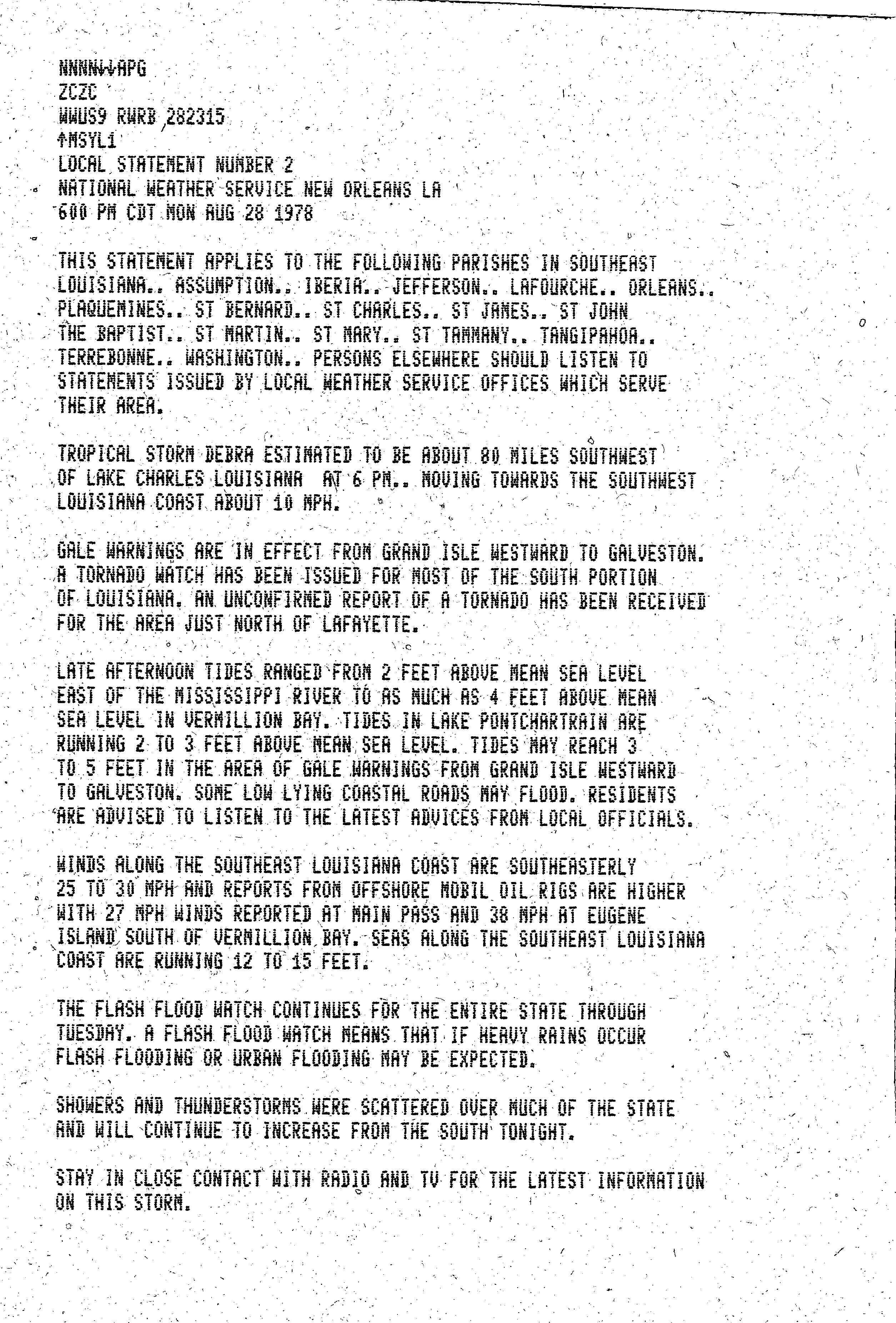
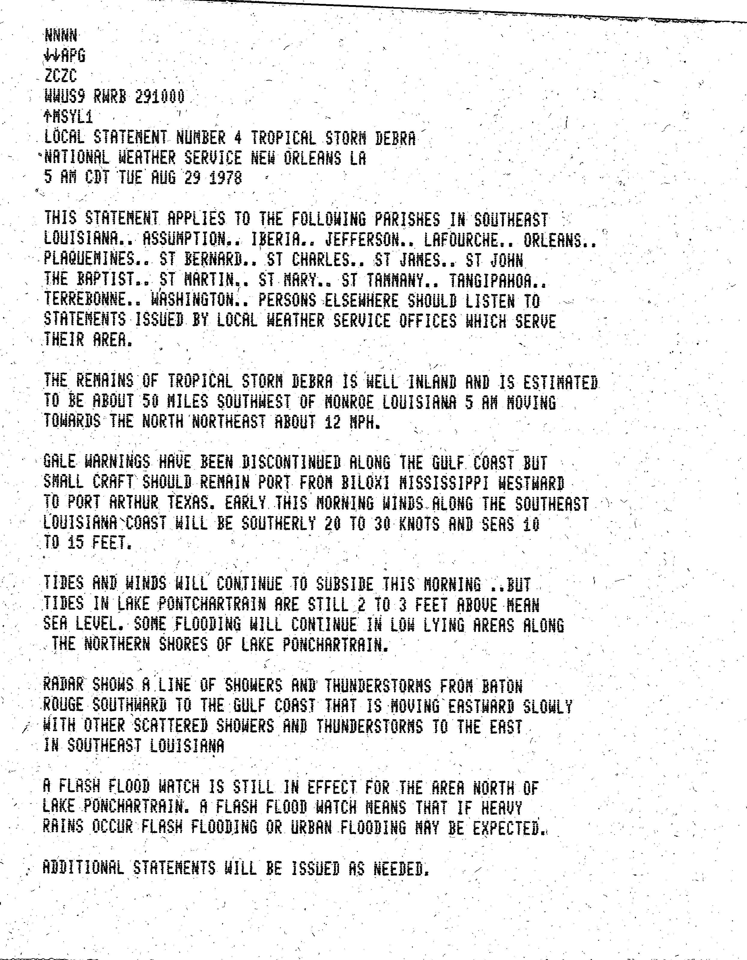
Tropical Storm Debra (1978)

Last updated

Map key
  Tropical depression (≤38 mph, ≤62 km/h)
  Tropical storm (39–73 mph, 63–118 km/h)
  Category 1 (74–95 mph, 119–153 km/h)
  Category 2 (96–110 mph, 154–177 km/h)
  Category 3 (111–129 mph, 178–208 km/h)
  Category 4 (130–156 mph, 209–251 km/h)
  Category 5 (≥157 mph, ≥252 km/h)
  Unknown
Storm type
Disc Plain black.svg Tropical cyclone
Solid black.svg Subtropical cyclone
ArrowUp.svg Extratropical cyclone, remnant low, tropical disturbance, or monsoon depression

Debra originated in an upper-level cold-core low pressure system that developed over southwestern Florida in late August 1978. The low moved southwest towards the Yucatán Peninsula over the next day, as a tropical wave drifted westwards from the Caribbean Sea. [1] The interaction between the upper-level system and the wave led to the formation of a tropical depression on August 26 around 460 miles (740 km) south of New Orleans. [1] [2]

At first the depression drifted westward but, as the western periphery of a high-pressure area weakened, it tracked towards the north and slowly strengthened. After a reconnaissance aircraft found surface winds of 45 mph (70 km/h) on August 28, the depression was upgraded to Tropical Storm Debra. The aircraft also recorded a minimum pressure of 1002 mbar (hPa; 29.59 inHg). [1] [2] [3] While Debra approached the coast of Louisiana, an additional flight into the system found a drop in surface pressure to 1000 mbar (hPa; 29.53 inHg), as well as peak winds of approximately 60 mph (100 km/h) at 00:00  GMT on August 29. [1] [2] [4] Observation stations off the coast recorded sustained winds of 45–50 mph (70–80 km/h) on August 28, as Debra passed 150 miles (240 km) to the west. [2] [3] [4]

The storm made landfall between Beaumont, Texas, and Lake Charles, Louisiana, on August 28. [4] Two stations recorded surface pressures of 1002 mbar (hPa; (29.59 inHg)). [3] As Debra moved north-northeast through Louisiana and Arkansas, the central pressure rose slightly. In south central Arkansas the residual low pressure system merged with a frontal trough on August 29; the frontal wave drifted into southern Illinois and traveled eastbound into the Ohio Valley for the next three days. [2] [4] Five tornadoes were reported from the system in Texas, Louisiana, and Mississippi shortly after Debra's landfall. [note 1]

Preparations and impact

Rainfall amounts caused by Tropical Storm Debra Debra 1978 rainfall.png
Rainfall amounts caused by Tropical Storm Debra

Louisiana

A flash flood watch was issued in advance of Debra for the whole of Louisiana. [11] ExxonMobil, Royal Dutch Shell, Chevron, and other oil companies shut down operations and evacuated about 1,000 employees from offshore oil rigs in Texas and Louisiana. [12] [13] Despite these evacuations, a 15-foot (4.6 m) wave killed a person at a rig 80 miles (130 km) offshore from Cameron. [14] [15] Three evacuation centers in Lake Charles, were set up to help those needing shelter and departing the Cameron area, [16] and the Red Cross opened four shelters at the Calcasieu Parish Public Schools. [12] In Louisiana, more than six thousand people were evacuated from Cameron Parish, [17] [18] as well as an undetermined number from Vermilion Parish. [1]

Louisiana had moderate flooding, especially in Rapides Parish. [19] Rainfall amounted to 6 inches (15 cm) at Lake Charles and Lafayette, 3 inches (7.6 cm) at Shreveport, and 3.5 inches (8.9 cm) at Monroe. [20] Flash flood warnings were issued during the storm for Louisiana, Mississippi, Arkansas, Missouri, and Tennessee. [21] By dawn on August 29, all rainwater had receded from the streets and tides were back to normal levels. [20]

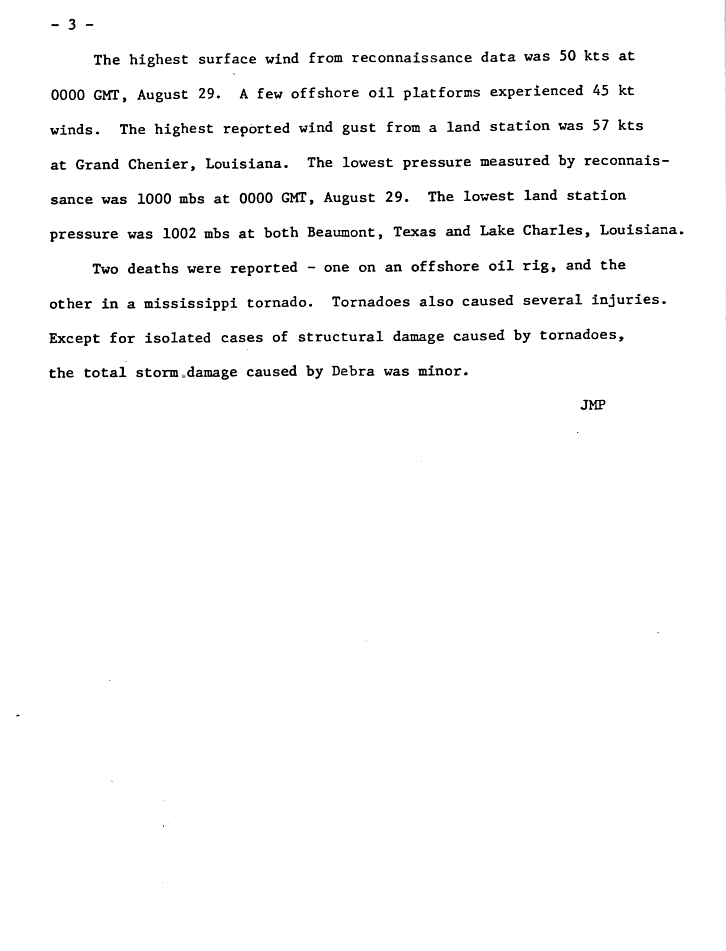
A confirmed tornado at the Ike settlement in Vernon Parish, knocked over a trailer. [4] [17] The greatest amount of rainfall caused by Debra, 10.81 in (275 mm), was recorded in Freshwater Bayou Lock. [2] [22] More than 6 in (150 mm) was recorded across Louisiana, [2] [4] [23] and tides between Atchafalaya Bay and Vermilion Bay were 5.7 ft (1.7 m) above normal. [2] [4] At Grand Chenier, a wind gust of 65 miles per hour (105 km/h) to 70 miles per hour (110 km/h) was recorded, [15] [16] and there were reports of downed trees and damage to roofs in Lake Charles and New Orleans. [13] Tides at Lake Pontchartrain were 2 feet (0.61 m) to 3 feet (0.91 m) above normal. [24]

Elsewhere

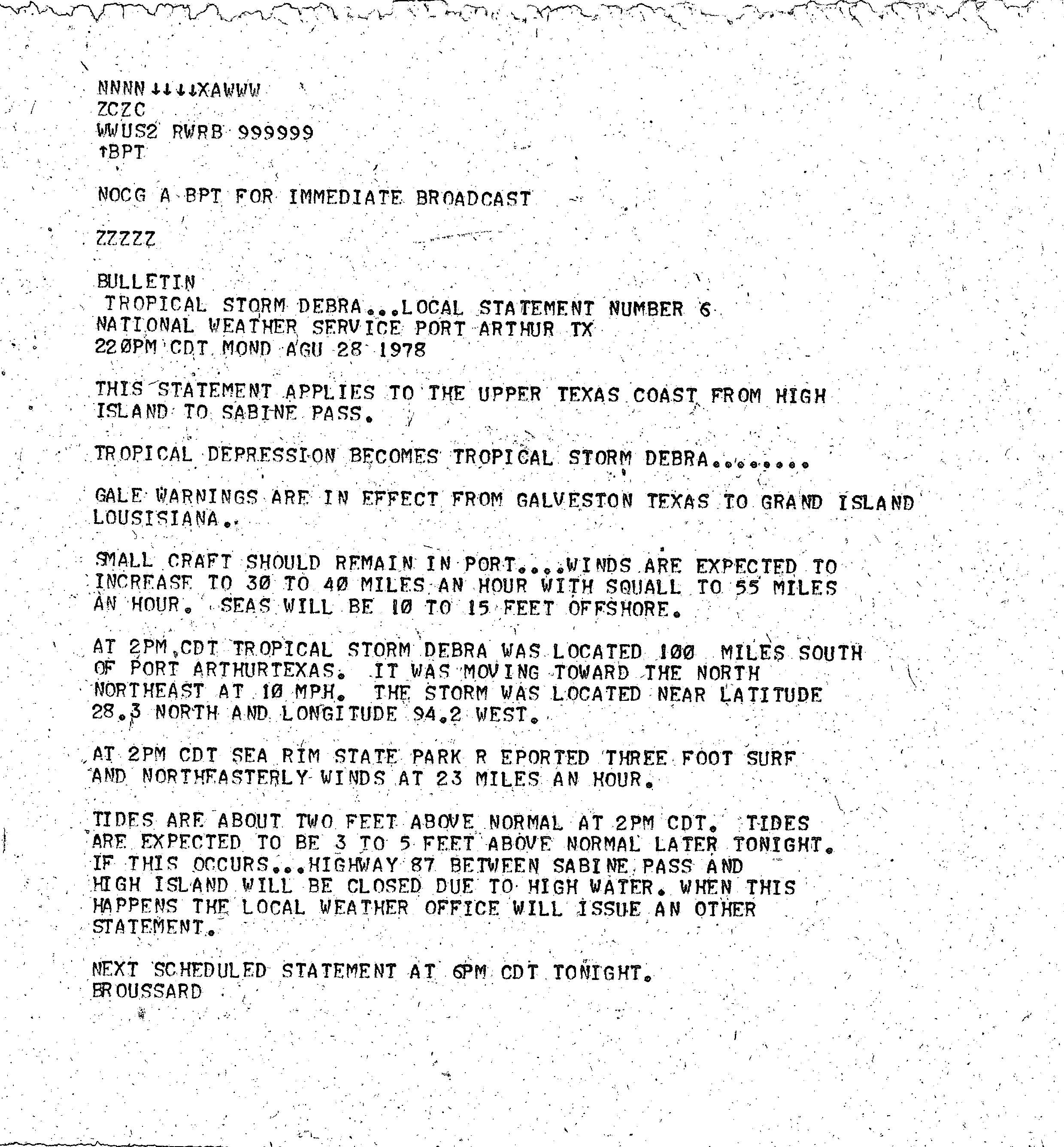
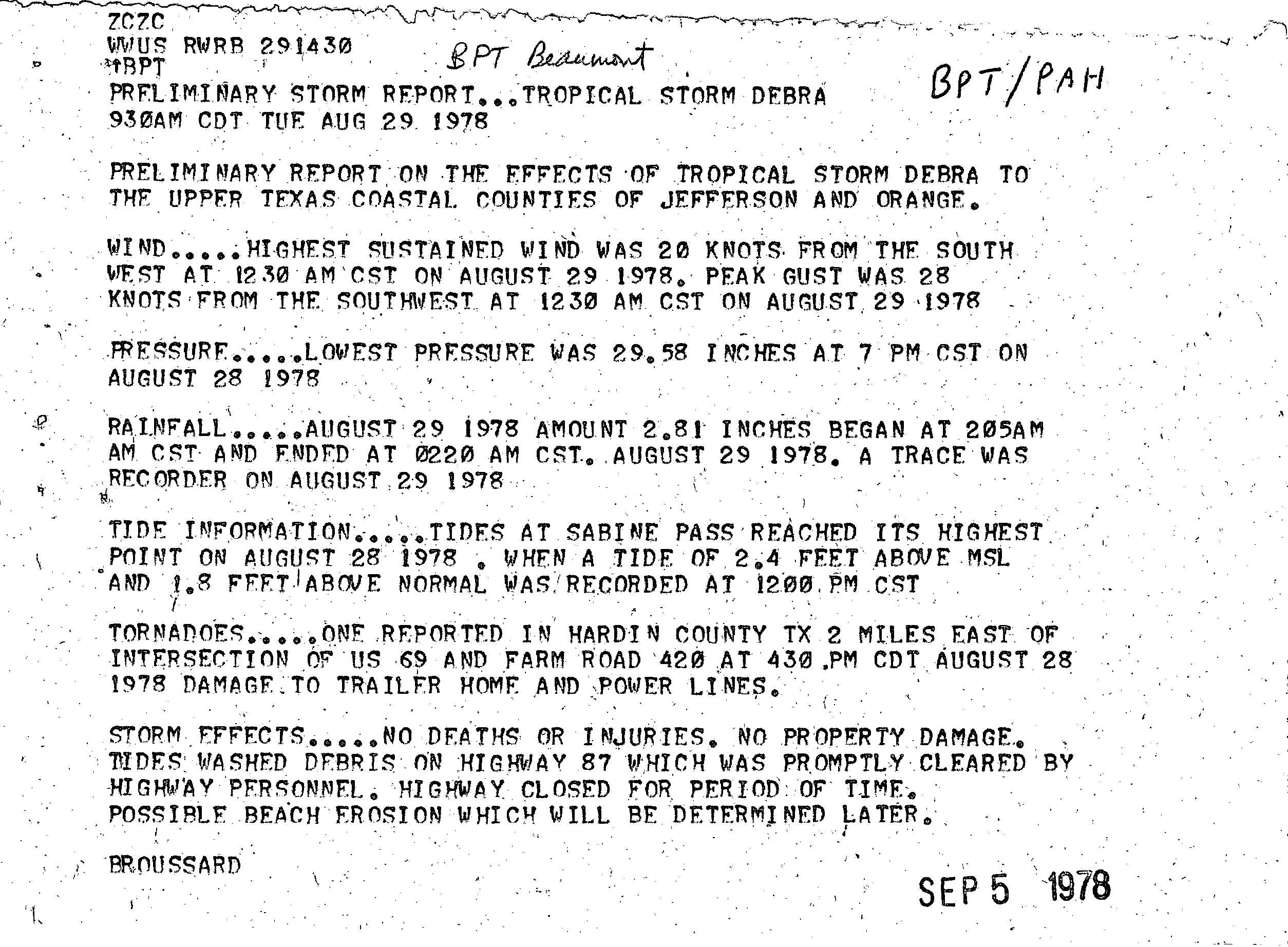
Gale warnings were prompted from Galveston, Texas, through to Grand Isle, Louisiana, at 18:00 GMT on August 28. [1] [25] A confirmed tornado in Hardin County, Texas, [26] damaged a trailer home and power lines. More than 6 inches (150 mm) of rainfall was recorded within Texas [4] and 7 inches (180 mm) in the Beaumont    Port Arthur area caused minor street flooding. [14] [19] Tides were 1 ft (0.30 m) above normal at Corpus Christi, while tides at Galveston were 2.2 ft (0.67 m) above normal. [2] [4]

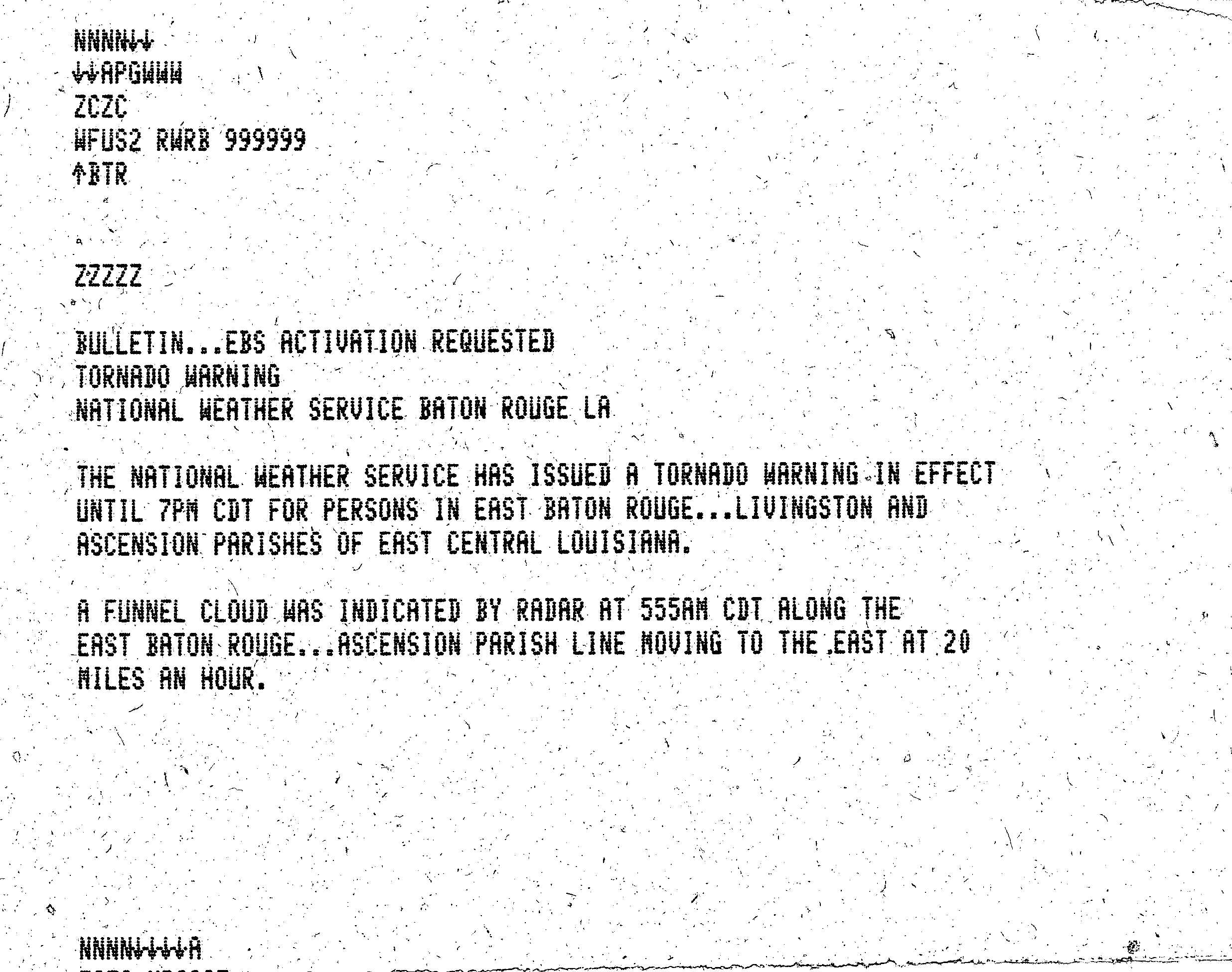
A tornado spawned in Turkey Creek, Mississippi, destroyed three mobile homes and a house, killing one person and seriously injuring another; this tornado tracked on to Crystal Springs, Mississippi. [27] [28] Many rice stands were knocked over because of the gusts of wind from Tropical Storm Debra. [29] Rainfall of more than 6 in (15 cm) was recorded in locations across Mississippi, Missouri, and Illinois. [2] [4] [15] Tornadoes were reported in Memphis, Tennessee; Little Rock, Arkansas; Starkville, Springdale, Cedarbluff and Flora in Mississippi; Livingston and Ascension parishes [30] and north Lafayette in Louisiana. [11] [31] One person was hurt in the Memphis tornado. [31] Power was knocked out at four blocks of the Memphis International Airport, [31] gas supplies were cut off in Memphis, and downed trees and power poles blocked many streets. [31] Overall damage caused by Debra was minimal. [17] [32]

See also

Notes

Footnotes

  1. Tornadoes were confirmed in Texas, [4] [5] [6] Louisiana, [4] [7] Mississippi, [4] [8] Arkansas, [9] and Tennessee. [10]

Citations

  1. 1 2 3 4 5 6 Pelisser, Joseph M. (1978). "Tropical Storm Debra Preliminary Report". National Hurricane Center. National Oceanic and Atmospheric Administration. p. 1. Retrieved 2011-06-30.
  2. 1 2 3 4 5 6 7 8 9 10 Lawrence, Miles B. (1979-01-29). "Atlantic Hurricane Season of 1978". Monthly Weather Review. American Meteorological Society. 107 (April 1979): 482–483. Bibcode:1979MWRv..107..477L. doi: 10.1175/1520-0493(1979)107<0477:AHSO>2.0.CO;2 . ISSN   1520-0493.
  3. 1 2 3 "Tropical Storm Debra Preliminary Report". National Hurricane Center. National Oceanic and Atmospheric Administration. 1978. p. 4. Retrieved 2011-07-01.
  4. 1 2 3 4 5 6 7 8 9 10 11 12 13 Pelisser, Joseph M. (1978). "Tropical Storm Debra Preliminary Report". National Hurricane Center. National Oceanic and Atmospheric Administration. p. 2. Retrieved 2011-06-30.
  5. "Tornado Climatology for Southeast Texas & Southwest Louisiana" (PDF). National Weather Service Central Region Headquarters. NWS Central Region Headquarters. Retrieved 2011-07-18.
  6. "Tornado History Project: 19780828.48.128". Storm Prediction Center . Tornado History Project. Retrieved 2011-07-18.
  7. "Tornado History Project: 19780828.22.14". Storm Prediction Center . Tornado History Project. Retrieved 2011-07-18.
  8. "Tornado History Project: 19780829.28.10". Storm Prediction Center . Tornado History Project. Retrieved 2011-07-18.
  9. "Tornado History Project: 19780829.5.35". Storm Prediction Center . Tornado History Project. Retrieved 2011-07-18.
  10. "Tornado History Project: 19780829.47.7". Storm Prediction Center . Tornado History Project. Retrieved 2011-07-18.
  11. 1 2 "Local Statement Number 2". National Weather Service New Orleans, Louisiana. National Weather Service . Retrieved 2011-07-05.
  12. 1 2 "Tropical Storm Debra Brings Battening Down". Sarasota Herald-Tribune . 1978-08-29. Retrieved 2011-07-01.
  13. 1 2 "Storm Hits Louisiana". Spokane Daily Chronicle . 1978-08-29. Retrieved 2011-07-01.
  14. 1 2 "Tropical storm zeros in on Louisiana coast". St. Petersburg Times . 1978-08-29. Retrieved 2011-07-01.
  15. 1 2 3 Pelisser, Joseph M. (1978). "Tropical Storm Debra Preliminary Report". National Hurricane Center. National Oceanic and Atmospheric Administration. p. 3. Retrieved 2011-06-30.
  16. 1 2 "Tropical storm slams into Texas, Louisiana". St. Petersburg Times . 1978-08-29. Retrieved 2011-07-01.
  17. 1 2 3 "Tropical Storm Debra Headed For Arkansas". The Evening Independent . 1978-08-29. Retrieved 2011-07-01.
  18. "Nation's weather". Daily News . 1978-08-29. Retrieved 2011-07-01.
  19. 1 2 "Tropical Storm Debra Weakens, Moves Inland". Toledo Blade . 1978-08-29. Retrieved 2011-07-01.
  20. 1 2 "Debra brings threat of tornadoes, floods". Daily Union . 1978-08-29. Retrieved 2011-07-01.
  21. "'Debra' makes devastating exit". Bangor Daily News . 1978-08-30. Retrieved 2011-07-06.
  22. Roth, David. "Tropical Storm Debra 1978". Hydrometeorological Prediction Center . Retrieved 2011-06-30.
  23. "Debra Produces Tornadoes, Rain". The Victoria Advocate . 1978-08-29. Retrieved 2011-06-30.
  24. "Local Statement Number 4". National Weather Service New Orleans, Louisiana. National Weather Service . Retrieved 2011-07-05.
  25. "Local Statement Number 6". National Hurricane Center tropical cyclone reports. National Hurricane Center . Retrieved 2011-07-05.
  26. "Preliminary Storm Report – Tropical Storm Debra 930AM CDT TUE AUG 29 1978". National Weather Service . National Weather Service . Retrieved 2011-07-17.
  27. "Debra Spawns Tornadoes: 1 Killed, Dozens Hurt". The News-Dispatch . 1978-08-30. Retrieved 2011-07-01.
  28. "Debra lumbers inland, causes minor flooding". The Deseret News . 1978-08-29. Retrieved 2011-07-01.
  29. "Mississippi Weather & Crop Report 1969-1978" (PDF). National Agricultural Statistics Service . United States Department of Agriculture. p. 13. Archived from the original (PDF) on 2011-10-24. Retrieved 2011-07-18.
  30. "TORNADO WARNING – WFUS2 RWSB 999999". National Weather Service Baton Rouge, Louisiana. National Weather Service.
  31. 1 2 3 4 "Woman dies; Elvis Boulevard hit: Spent Debra sends tornadoes through South". Eugene Register-Guard . 1978-08-30. Retrieved 2011-07-01.
  32. "In the aftermath of Debra". St. Petersburg Times . 1978-08-30. Retrieved 2011-07-01.
Tropical Storm Debra
DebraAugust281978afternoon.gif
Tropical Storm Debra making its landfall on August 28.

Related Research Articles

<span class="mw-page-title-main">Tropical Storm Allison</span> Atlantic tropical storm in 2001

Tropical Storm Allison was a tropical storm that devastated southeast Texas in June of the 2001 Atlantic hurricane season. An arguable example of the "brown ocean effect", Allison lasted unusually long for a June storm, remaining tropical or subtropical for 16 days, most of which was when the storm was over land dumping torrential rainfall. The storm developed from a tropical wave in the northern Gulf of Mexico on June 4, 2001, and struck the upper Texas coast shortly thereafter. It drifted northward through the state, turned back to the south, and re-entered the Gulf of Mexico. The storm continued to the east-northeast, made landfall on Louisiana, then moved across the southeast United States and Mid-Atlantic. Allison was the first storm since Tropical Storm Frances in 1998 to strike the northern Texas coastline.

<span class="mw-page-title-main">1978 Atlantic hurricane season</span> Hurricane season in the Atlantic Ocean

The 1978 Atlantic hurricane season was a slightly above average hurricane season in terms of number of named storms. Eleven tropical cyclones were named in all, and five of these became hurricanes; two of the five became a major hurricane. This was also the last Atlantic hurricane season to use an all-female naming list. The season officially began on June 1, 1978, and ended on November 30, 1978. These dates, adopted by convention, denote the period in each year when most tropical cyclogenesis occurs in the Atlantic basin. However, the formation of subtropical or tropical cyclones is possible at any time of the year, as shown by the formation of an unnamed subtropical storm on January 18.

<span class="mw-page-title-main">1957 Atlantic hurricane season</span> Hurricane season in the Atlantic Ocean

The 1957 Atlantic hurricane season featured one of the longest-travelling tropical cyclones in the Atlantic basin, Hurricane Carrie. Nevertheless, the season was generally inactive, with eight tropical storms – two of which went unnamed – and three hurricanes, two of which intensified further to attain major hurricane intensity. The season officially began on June 15 and ended on November 15, though the year's first tropical cyclone developed prior to the start of the season on June 8. The final storm dissipated on October 27, well before the official end of the season. The strongest hurricane of the year was Carrie, which reached the equivalent of a Category 4 hurricane on the Saffir–Simpson hurricane scale on two separate occasions in the open Atlantic; Carrie later caused the sinking of the German ship Pamir southwest of the Azores, resulting in 80 deaths.

<span class="mw-page-title-main">Hurricane Rita</span> Category 5 Atlantic hurricane in 2005

Hurricane Rita was the most intense tropical cyclone on record in the Gulf of Mexico and the fourth-most intense Atlantic hurricane ever recorded. Part of the record-breaking 2005 Atlantic hurricane season, which included three of the top ten most intense Atlantic hurricanes in terms of barometric pressure ever recorded, Rita was the seventeenth named storm, tenth hurricane, and fifth major hurricane of the 2005 season. It was also the earliest-forming 17th named storm in the Atlantic until Tropical Storm Rene in 2020. Rita formed near The Bahamas from a tropical wave on September 18, 2005 that originally developed off the coast of West Africa. It moved westward, and after passing through the Florida Straits, Rita entered an environment of abnormally warm waters. Moving west-northwest, it rapidly intensified to reach peak winds of 180 mph (285 km/h), achieving Category 5 status on September 21. However, it weakened to a Category 3 hurricane before making landfall in Johnson's Bayou, Louisiana, between Sabine Pass, Texas and Holly Beach, Louisiana, with winds of 115 mph (185 km/h). Rapidly weakening over land, Rita degenerated into a large low-pressure area over the lower Mississippi Valley by September 26th.

<span class="mw-page-title-main">Hurricane Juan (1985)</span> Category 1 Atlantic hurricane in 1985

Hurricane Juan was a large and erratic tropical cyclone that looped twice near the Louisiana coast, causing widespread flooding. It was the tenth named storm of the 1985 Atlantic hurricane season, forming in the central Gulf of Mexico in late October. Juan moved northward after its formation, and was subtropical in nature with its large size. On October 27, the storm became a hurricane, reaching maximum sustained winds of 85 mph (140 km/h). Due to the influence of an upper-level low, Juan looped just off southern Louisiana before making landfall near Morgan City on October 29. Weakening to tropical storm status over land, Juan turned back to the southeast over open waters, crossing the Mississippi River Delta. After turning to the northeast, the storm made its final landfall just west of Pensacola, Florida, late on October 31. Juan continued quickly to the north and was absorbed by an approaching cold front, although its moisture contributed to a deadly flood event in the Mid-Atlantic states.

<span class="mw-page-title-main">Tropical Storm Matthew (2004)</span> Atlantic tropical storm in 2004

Tropical Storm Matthew was a weak tropical storm in the 2004 Atlantic hurricane season that made landfall on Louisiana. It was the thirteenth tropical storm of the season and the ninth to affect the United States. It formed over the western Gulf of Mexico on October 8 and struck south-central Louisiana two days later. The combination of the storm and an upper cyclone over the southern Plains brought heavy rains to much of the Gulf Coast, with the highest amounts reported over 15 inches (380 mm) in northern Louisiana. Damage was minimal, totaling $305,000 (2004 USD), and no casualties were reported.

<span class="mw-page-title-main">Tropical Storm Frances (1998)</span> Atlantic tropical storm in 1998

Tropical Storm Frances caused extensive flooding in Mexico and Texas in September 1998. The sixth tropical cyclone and sixth named storm of the annual hurricane season, Frances developed from a low pressure area in the Gulf of Mexico on September 8. The cyclone moved northward through the western Gulf of Mexico, making landfall across the central Texas coastline before recurving across the Midwest through southeast Canada and New England. A large tropical cyclone for the Atlantic basin, yet an average sized system by western Pacific standards, the storm produced heavy rains across the Isthmus of Tehuantepec, Texas, western Louisiana and the Great Plains.

<span class="mw-page-title-main">Hurricane Audrey</span> Category 3 Atlantic hurricane in 1957

Hurricane Audrey was one of the deadliest tropical cyclones in U.S. history, killing at least 416 people in its devastation of the southwestern Louisiana coast in 1957. Along with Hurricane Alex in 2010, it was also the strongest June hurricane ever recorded in the Atlantic basin as measured by pressure. The rapidly developing storm struck southwestern Louisiana as an intense Category 3 hurricane, destroying coastal communities with a powerful storm surge that penetrated as far as 20 mi (32 km) inland. Audrey was the first named storm and hurricane of the 1957 hurricane season. It formed on June 24 from a tropical wave that moved into the Bay of Campeche. Situated within ideal conditions for tropical development, Audrey quickly strengthened, reaching hurricane status a day afterwards. Moving north, it continued to strengthen and accelerate as it approached the United States Gulf Coast. On June 27, the hurricane reached peak sustained winds of 125 mph (205 km/h), making it a major hurricane. At the time, Audrey had a minimum barometric pressure of 946 mbar. The hurricane made landfall with the same intensity between the mouth of the Sabine River and Cameron, Louisiana, later that day, causing unprecedented destruction across the region. Once inland, Audrey weakened and turned extratropical over West Virginia on June 29. Audrey was the first major hurricane to form in the Gulf of Mexico since 1945.

<span class="mw-page-title-main">Tropical Storm Bill (2003)</span> Atlantic tropical cyclone

Tropical Storm Bill was a tropical storm that affected the Gulf Coast of the United States in the summer of 2003. The second storm of the 2003 Atlantic hurricane season, Bill developed from a tropical wave on June 29 to the north of the Yucatán Peninsula. It slowly organized as it moved northward, and reached a peak of 60 miles per hour (97 km/h) shortly before making landfall in south-central Louisiana. Bill quickly weakened over land, and as it accelerated to the northeast, moisture from the storm, combined with cold air from an approaching cold front, produced an outbreak of 34 tornadoes. Bill became extratropical on July 2, and was absorbed by the cold front later that day.

<span class="mw-page-title-main">Tropical Storm Hermine (1998)</span> Atlantic tropical cyclone

Tropical Storm Hermine was the eighth tropical cyclone and named storm of the 1998 Atlantic hurricane season. Hermine developed from a tropical wave that emerged from the west coast of Africa on September 5. The wave moved westward across the Atlantic Ocean, and on entering the northwest Caribbean interacted with other weather systems. The resultant system was declared a tropical depression on September 17 in the central Gulf of Mexico. The storm meandered north slowly, and after being upgraded to a tropical storm made landfall on Louisiana, where it quickly deteriorated into a tropical depression again on September 20.

<span class="mw-page-title-main">Tropical Storm Chris (1982)</span> Atlantic tropical storm in 1982

Tropical Storm Chris caused minor flooding along the Gulf Coast of the United States in September 1982. The fifth tropical or subtropical cyclone and third named storm of the 1982 Atlantic hurricane season, Chris developed from a surface low-pressure area in the northern Gulf of Mexico on September 9. Although initially displaying subtropical characteristics, the low pressure area gradually acquired tropical characteristics, and was reclassified as Tropical Depression Four within 24 hours of development. The depression then began to intensify and was upgraded to Tropical Storm Chris on September 10. Thereafter, the storm turned north-north-eastward and strengthened further. On September 11, Chris peaked as a 65 mph (100 km/h) tropical storm. Later that day, it made landfall near Sabine Pass, Port Arthur, Texas. By September 13, Chris dissipated over Arkansas.

<span class="mw-page-title-main">Hurricane Humberto (2007)</span> Category 1 Atlantic hurricane in 2007

Hurricane Humberto was a Category 1 hurricane that formed and intensified faster than any other North Atlantic tropical cyclone on record, before landfall. The eighth named storm and third hurricane of the 2007 Atlantic hurricane season, Humberto developed on September 12, 2007, in the northwestern Gulf of Mexico,. The tropical cyclone rapidly strengthened and struck High Island, Texas, with winds of about 90 mph (140 km/h) early on September 13. It steadily weakened after moving ashore, and on September 14, Humberto began dissipating over northwestern Georgia as it interacted with an approaching cold front.

<span class="mw-page-title-main">Tropical Depression Ten (2007)</span> Atlantic tropical cyclone

Tropical Depression Ten was a short-lived tropical cyclone that made landfall on the Florida Panhandle in September 2007. The system developed as a subtropical depression on September 21 in the northeastern Gulf of Mexico from the interaction of a tropical wave, the tail end of a cold front, and an upper-level low. Initially containing a poorly defined circulation and intermittent thunderstorm activity, the system transitioned into a tropical depression after convection increased over the center. Tracking northwestward, the depression moved ashore near Fort Walton Beach early on September 22 and dissipated over southeastern Alabama shortly thereafter.

<span class="mw-page-title-main">Tropical Storm Danielle (1980)</span> Atlantic tropical storm in 1980

Tropical Storm Danielle caused considerable flooding in the state of Texas during September 1980. The eighth tropical cyclone and fourth named storm of the 1980 Atlantic hurricane season, Danielle developed from a tropical wave that emerged into the Atlantic Ocean from the west coast of Africa on August 22. Three days later, the tropical wave developed into a tropical depression. Four days later, the depression degenerated into a tropical wave. After tracking westward and entering the Gulf of Mexico, the system gradually developed, and became a tropical depression on September 4. The depression gradually strengthened and became Tropical Storm Danielle only hours before landfall in eastern Texas on September 5. Danielle steadily weakened inland and dissipated two days later.

<span class="mw-page-title-main">Hurricane Debra (1959)</span> Category 1 Atlantic hurricane in 1959

Hurricane Debra was a destructive tropical cyclone that developed during the 1959 Atlantic hurricane season. The fifth tropical storm and third hurricane of the season, Debra originated from the interaction of a cold-core low and a tropical wave on July 15. The system was designated a tropical depression on July 23 when it was south of Louisiana and meandered westward while it swiftly intensified into a tropical storm along the Gulf Coast of the United States. A turn towards the northwest became evident as it attained Category 1 hurricane status on the Saffir–Simpson Hurricane Scale the following day while it organized into a developed storm. As the hurricane curved northward at a slow forward speed, strength was maintained as it approached the coast of Texas as a minimal hurricane. It came ashore during the evening of July 24 local time between Freeport and Galveston, Texas. It rapidly weakened into a tropical storm and later a depression as it moved inland, and dissipated on July 28 while it turned northwestward. The remnant moisture later sparked upper-level thunderstorms in late July and early August.

<span class="mw-page-title-main">1933 Texas tropical storm</span> Atlantic tropical storm in 1933

The 1933 Texas tropical storm produced record rainfall in the south-central United States in July of the 1933 Atlantic hurricane season. It was the third storm of the season, developing on July 14 near the Lesser Antilles. While moving westward through the Caribbean Sea, the cyclone passed just south of Jamaica on July 16. The storm dropped heavy rainfall on the island that caused flooding and road washouts. On July 18, the storm struck Belize and later moved across the Yucatán Peninsula. Initially it was believed that the storm continued into Mexico and dissipated while another storm formed to its northeast, but it was discovered in 2012 that the storm followed one continuous track.

<span class="mw-page-title-main">Hurricane Barry (2019)</span> Category 1 Atlantic hurricane in 2019

Hurricane Barry was an asymmetrical Category 1 hurricane that was the wettest tropical cyclone on record in Arkansas and the fourth-wettest in Louisiana. The second tropical or subtropical storm and first hurricane of the 2019 Atlantic hurricane season, Barry originated as a mesoscale convective vortex over southwestern Kansas on July 2. The system eventually emerged into the Gulf of Mexico from the Florida Panhandle on July 10, whereupon the National Hurricane Center (NHC) designated it as a potential tropical cyclone. Early on July 11, the system developed into a tropical depression, and strengthened into a tropical storm later that day. Dry air and wind shear caused most of the convection, or thunderstorms, to be displaced south of the center. Nevertheless, Barry gradually intensified. On July 13, Barry attained its peak intensity as Category 1 hurricane with 1-minute sustained winds of 75 mph (120 km/h) and a minimum central pressure of 993 millibars (29.3 inHg). At 15:00 UTC, Barry made its first landfall at Marsh Island, and another landfall in Intracoastal City, Louisiana, both times as a Category 1 hurricane. Barry quickly weakened after landfall, falling to tropical depression status on July 15. The storm finally degenerated into a remnant low over northern Arkansas on the same day, subsequently opening up into a trough on July 16. The storm's remnants persisted for another few days, while continuing its eastward motion, before being absorbed into another frontal storm to the south of Nova Scotia on July 19.

<span class="mw-page-title-main">Hurricane Laura</span> Category 4 Atlantic hurricane in 2020

Hurricane Laura was a deadly and destructive Category 4 hurricane that is tied with the 1856 Last Island hurricane and 2021's Hurricane Ida as the strongest hurricane on record to make landfall in the U.S. state of Louisiana, as measured by maximum sustained winds. The twelfth named storm, fourth hurricane, and first major hurricane of the record-breaking 2020 Atlantic hurricane season, Laura originated from a large tropical wave that moved off the West African coast on August 16 and became a tropical depression on August 20. Laura intensified into a tropical storm a day later, becoming the earliest twelfth named storm on record in the North Atlantic basin, forming eight days earlier than 1995's Hurricane Luis.

<span class="mw-page-title-main">Tropical Storm Beta (2020)</span> Atlantic tropical storm in 2020

Tropical Storm Beta was a tropical cyclone that brought heavy rainfall, flooding, and severe weather to the Southeastern United States in September 2020. The twenty-third tropical depression and twenty-third named storm of the record-breaking 2020 Atlantic hurricane season, Beta originally formed from a trough of low pressure that developed in the northeastern Gulf of Mexico on September 10. The low moved slowly southwestward, with development hampered initially by the development of nearby Hurricane Sally. After Sally moved inland over the Southeastern United States and weakened, the disturbance became nearly stationary in the southwestern Gulf, where it began to organize. By September 16, the storm had gained a low-level circulation center and had enough organization to be designated as Tropical Depression Twenty-Two. The system held its intensity for a day due to the influence of strong wind shear and dry air, before eventually attaining tropical storm strength. It slowly moved northward and intensified to a mid-range tropical storm before dry air and wind shear halted its intensification. Beta then became nearly stationary on September 19, before starting to move west towards the Texas coast the next day, weakening as it approached. On September 21, Beta made landfall near Matagorda Peninsula, Texas as a minimal tropical storm. It subsequently weakened to a tropical depression the next day before becoming post-tropical early on September 23. Its remnants moved northeastward, before the center elongated and merged with a cold front early on September 25.