Medina River Río Mariano, Río San Jose, Río de Bagres | |
---|---|
Location | |
Country | United States |
State | Texas |
Physical characteristics | |
Source | |
• location | Bandera County, Texas |
• coordinates | 29°47′46″N99°15′19″W / 29.79611°N 99.25528°W [1] |
Mouth | San Antonio River |
• location | Bexar County, Texas |
• coordinates | 29°14′04″N98°24′28″W / 29.23444°N 98.40778°W Coordinates: 29°14′04″N98°24′28″W / 29.23444°N 98.40778°W [1] |
• elevation | 128 m (420 ft) |
The Medina River is located in south central Texas, United States, in the Medina Valley. It was also known as the Rio Mariano, Rio San Jose, or Rio de Bagres (Catfish river). Its source is in springs in the Edwards Plateau in northwest Bandera County, Texas and merges with the San Antonio River in southern Bexar County, Texas, for a course of 120 miles. It contains the Medina Dam in NE Medina County, Texas which restrains Lake Medina. Much of its course is owned and operated by the Bexar-Medina-Atascosa Water District to provide irrigation services to farmers and ranchers.
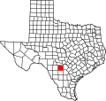
The Medina River was named after Pedro de Medina, a Spanish cartographer, by Alonso de León, Spanish governor of Coahuila, New Spain in 1689. It once served as the official boundary between Texas and Coahuila [2] with the San Antonio River being considered its tributary. At that time, the river was called the Medina all the way to the Gulf of Mexico, but now the part below the confluence is called the San Antonio River.
From 1849, Castroville on the river was a water stop on the San Antonio-El Paso Road and a stagecoach station on the San Antonio-El Paso Mail and San Antonio-San Diego Mail Line.
Much of the source water to the Medina River is produced by springs emerging due to the presence of the Balcones Fault. This locale of the Balcones Fault is associated with an important ecological dividing line for species occurrence. For example, species such as the California Fan Palm, Washingtonia filifera , occur only west of the Medina River or Balcones Fault. [3]
The Medina River once received significant waste discharge from upstream catfish farming operations, which utilized more water than was sustainable to the basin's safe usage. [4]
Medina County is a county located in the U.S. state of Texas. As of the 2020 census, its population was 50,748. Its county seat is Hondo. The county is named for the Medina River. The extreme northern part of the county lies within the Edwards Plateau, which elevates into the Texas Hill Country. The Medina Dam, the fourth largest in the nation when completed in 1913, is listed on the National Register of Historic Places. The irrigation project, creating Medina Lake, was built by 1500 skilled workers who worked in shifts operating 24 hours a day to complete the dam in two years. Medina County is part of the San Antonio, TX Metropolitan Statistical Area.
Bexar County is a county in the U.S. state of Texas. It is in South Texas and its county seat is San Antonio.
The Texas Hill Country is a geographic region of Central and South Texas, forming the southeast part of the Edwards Plateau. Given its location, climate, terrain, and vegetation, the Hill Country can be considered the border between the American Southeast and Southwest. The region represents the very remote rural countryside of Central Texas, but also is home to growing suburban neighborhoods and affluent retirement communities.
The Balcones Fault or Balcones Fault Zone is an area of largely normal faulting in the U.S. state of Texas that runs roughly from the southwest part of the state near Del Rio to the north-central region near Dallas along Interstate 35. The Balcones Fault zone is made up of many smaller features, including normal faults, grabens, and horsts. One of the obvious features is the Mount Bonnell Fault.
The Edwards Plateau is a geographic region at the crossroads of Central, South, and West Texas. It is bounded by the Balcones Fault to the south and east, the Llano Uplift and the Llano Estacado to the north, and the Pecos River and Chihuahuan Desert to the west. San Angelo, Austin, San Antonio, and Del Rio roughly outline the area. The southeast portion of the plateau is known as the Texas Hill Country.
Medina Lake is a reservoir on the Medina River in the Texas Hill Country of the United States. It is operated by the Bexar/Medina/Atascosa County Agricultural District. Medina Dam was completed in 1913 in a privately financed project, creating the lake to supply irrigation water for local agricultural use. Lake Medina is in northeastern Medina County, and southeastern Bandera County, about 40 miles (64 km) northwest of San Antonio.
Medina Valley, also known as the Medina River Valley, is an area in south central Texas containing the Medina River, Lake Medina, and the Medina Dam. It serves to drain the Balcones Escarpment of the Texas Hill Country and irrigate the fire contained therein. It is approximately 120 miles long and is named for the Medina River.
Washingtonia filifera, the desert fan palm, California fan palm, or California palm, is a flowering plant in the palm family Arecaceae, native to the far southwestern United States and Baja California, Mexico. Growing to 15–20 m (49–66 ft) tall by 3–6 m (10–20 ft) broad, it is an evergreen monocot with a tree-like growth habit. It has a sturdy, columnar trunk and waxy, fan-shaped (palmate) leaves.
Comal Springs are the largest concentration of naturally occurring freshwater springs in Texas. They are located in the city of New Braunfels and are the result of water percolating through the Edwards Aquifer formation.
The Texas Coastal Bend, or just the Coastal Bend, is a geographical region in the US state of Texas. The name refers to the area being a curve along the Texas Gulf Coast of the Gulf of Mexico. The largest city of the Coastal Bend is Corpus Christi. It includes the Nueces Estuary and the Mission–Aransas Estuary, as well as part of Laguna Madre. The coastline is paralleled by several of the Texas barrier islands, including North Padre Island, Mustang Island, and San José Island.
Cibolo Creek is a stream in South Central Texas that runs approximately 96 miles (154 km) from its source at Turkey Knob near Boerne, Texas, to its confluence with the San Antonio River in Karnes County. The creek is a tributary of the San Antonio River, at the easternmost part of its watershed.
The geography of Texas is diverse and large. Occupying about 7% of the total water and land area of the U.S., it is the second largest state after Alaska, and is the southernmost part of the Great Plains, which end in the south against the folded Sierra Madre Oriental of Mexico. Texas is in the South Central United States of America, and is considered to form part of the U.S. South and also part of the U.S. Southwest.
San Marcos Springs is the second largest natural cluster of springs in Texas. The springs are located in the city of San Marcos, Texas, about 30 miles (48 km) southwest of Austin and 46 miles (74 km) northeast of San Antonio.
Salado Springs is the name of five groups of springs at the town of Salado in Bell County, Texas, in the United States. The springs are located 48 miles (77 km) north of Austin or 135 miles (217 km) south of Dallas.
San Pedro Springs is the name of a cluster of springs in Bexar County, Texas, U.S.A. These springs provide water for San Pedro Creek, which flows into the San Antonio River. The San Antonio Springs also feed into the San Antonio River.
Greater San Antonio, officially designated San Antonio–New Braunfels, is an eight-county metropolitan area in the U.S. state of Texas defined by the Office of Management and Budget (OMB). The metropolitan area straddles South Texas and Central Texas and is on the southwestern corner of the Texas Triangle. The official 2020 U.S. census showed the metropolitan area's population at 2,558,143—up from a reported 1,711,103 in 2000—making it the 24th largest metropolitan area in the United States. Austin–Round Rock lies about 80 mi (130 km) northeast of Greater San Antonio.
Antonio de San Buenaventura y Olivares or simply Fray Antonio de Olivares was a Spanish Franciscan who officiated at the first Catholic Mass celebrated in Texas, and he was known for contributing to the founding of San Antonio and to the prior exploration of the area. He founded, among other missions, the Alamo Mission in San Antonio, the Presidio San Antonio de Bexar, and the Acequia Madre de Valero.
Presidio de Béxar was a Spanish fort built near the San Antonio River, located in what is now San Antonio, Texas, in the United States. It was designed for protection of the mission San Antonio de Valero and the Villa de Béjar. The Presidio de Béxar was founded on May 5, 1718 by Spanish colonial official Martín de Alarcón and his party of thirty-five soldiers. The Villa de Béjar is known for being the first Spanish settlement of San Antonio and consisted of the families of the Presidio Soldiers and those of the prior expeditions. It also served to secure Spain's claim to the region against possible encroachment from other European powers.
Leon Creek is a tributary stream of the Medina River, in Bexar County, Texas.
Seco Creek, is a tributary stream of the Hondo Creek, in Frio County, Texas. Named Rio Seco in 1689 by Captain Alonso De León, governor of Coahuila, when his expedition crossed the creek.