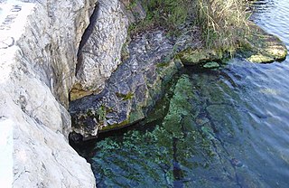
Barton Springs is a set of four natural water springs located at Barton Creek on the grounds of Zilker Park in Austin, Texas, resulting from water flowing through the Edwards Aquifer. The largest spring, Main Barton Spring, supplies water to Barton Springs Pool, a popular recreational destination in Austin. The smaller springs are located nearby, two with man-made structures built to contain and direct their flow. The springs are the only known habitat of the Barton Springs Salamander, an endangered species.

The Texas Hill Country is a geographic region of Central and South Texas, forming the southeast part of the Edwards Plateau. Given its location, climate, terrain, and vegetation, the Hill Country can be considered the border between the American Southeast and Southwest. The region represents the very remote rural countryside of Central Texas, but also is home to growing suburban neighborhoods and affluent retirement communities.
The Llano Uplift is a geologically ancient, low geologic dome that is about 90 miles (140 km) in diameter and located mostly in Llano, Mason, San Saba, Gillespie, and Blanco counties, Texas. It consists of an island-like exposure of Precambrian igneous and metamorphic rocks surrounded by outcrops of Paleozoic and Cretaceous sedimentary strata. At their widest, the exposed Precambrian rocks extend about 65 miles (105 km) westward from the valley of the Colorado River and beneath a broad, gentle topographic basin drained by the Llano River. The subdued topographic basin is underlain by Precambrian rocks and bordered by a discontinuous rim of flat-topped hills. These hills are the dissected edge of the Edwards Plateau, which consist of overlying Cretaceous sedimentary strata. Within this basin and along its margin are down-faulted blocks and erosional remnants of Paleozoic strata which form prominent hills.

The Edwards Plateau is a geographic region forming the crossroads of Central, South and West Texas, United States. It is bounded by the Balcones Fault to the south and east; the Llano Uplift and the Llano Estacado to the north; and the Pecos River and Chihuahuan Desert to the west. San Angelo, Austin, San Antonio and Del Rio roughly outline the area. The plateau, especially its southeast portion, is also known as the Texas Hill Country.

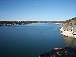
Mount Bonnell, also known as Covert Park, is a prominent point alongside the Lake Austin portion of the Colorado River in Austin, Texas. It has been a popular tourist destination since the 1850s. The mount provides a vista for viewing the city of Austin, Lake Austin, and the surrounding hills. It was designated a Recorded Texas Historic Landmark in 1969, bearing Marker number 6473, and was listed on the National Register of Historic Places in 2015.
Medina Valley, also known as the Medina River Valley, is an area in south central Texas containing the Medina River, Lake Medina, and the Medina Dam. It serves to drain the Balcones Escarpment of the Texas Hill Country and irrigate the crop fields contained therein. It is approximately 120 miles long and is named for the Medina River.
The Medina River is located in south central Texas, United States, in the Medina Valley. It was also known as the Rio Mariano, Rio San Jose, or Rio de Bagres. Its source is in springs in the Edwards Plateau in northwest Bandera County, Texas and merges with the San Antonio River in southern Bexar County, Texas, for a course of 120 miles. It contains the Medina Dam in NE Medina County, Texas which restrains Lake Medina. Much of its course is owned and operated by the Bexar-Medina-Atascosa Water District to provide irrigation services to farmers and ranchers.

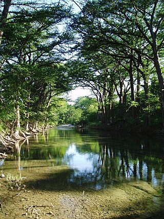
Barton Creek is a tributary that feeds the Colorado River as it flows through the Texas Hill Country. The creek passes through some of the more scenic areas in Greater Austin, surrounded in many parts by a greenbelt of protected lands that serves as a habitat for many indigenous species of flora and fauna. The creek passes through Barton Creek Greenbelt and is fed by Barton Springs.
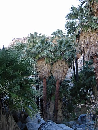
Washingtonia filifera, the desert fan palm, California fan palm, or California palm, is a flowering plant in the palm family Arecaceae, native to the far southwestern United States and Baja California, Mexico. Growing to 15–20 m (49–66 ft) tall by 3–6 m (10–20 ft) broad, it is an evergreen monocot with a tree-like growth habit. It has a sturdy, columnar trunk and waxy, fan-shaped (palmate) leaves.

The Edwards Aquifer is one of the most prolific artesian aquifers in the world. Located on the eastern edge of the Edwards Plateau in the U.S. state of Texas, it is the source of drinking water for two million people, and is the primary water supply for agriculture and industry in the aquifer's region. Additionally, the Edwards Aquifer feeds the Comal and San Marcos Springs, provides springflow for recreational and downstream uses in the Nueces, San Antonio, Guadalupe, and San Marcos river basins, and is home to several unique and endangered species.

The Dallas–Fort Worth Metroplex sits above Cretaceous-age strata ranging from ≈145-66 Ma. These Cretaceous-aged sediments lie above the eroded Ouachita Mountains and the Fort Worth Basin, which was formed by the Ouachita Orogeny. Going from west to east in the DFW Metroplex and down towards the Gulf of Mexico, the strata get progressively younger. The Cretaceous sediments dip very gently to the east.
Texas contains a wide variety of geologic settings. The state's stratigraphy has been largely influenced by marine transgressive-regressive cycles during the Phanerozoic, with a lesser but still significant contribution from late Cenozoic tectonic activity, as well as the remnants of a Paleozoic mountain range.

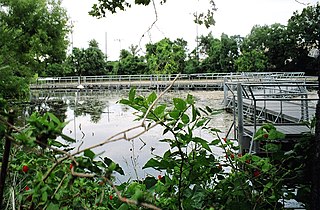
Comal Springs are the largest concentration of naturally occurring freshwater springs in Texas. They are located in the city of New Braunfels and are the result of water percolating through the Edwards Aquifer formation.

The Texas Coastal Bend, or just the Coastal Bend, is a geographical region in the US state of Texas. The name refers to the area being a curve along the Texas Gulf Coast of the Gulf of Mexico. The largest city of the Coastal Bend is Corpus Christi. It includes the Nueces Estuary and the Mission–Aransas Estuary, as well as part of Laguna Madre. The coastline is paralleled by several of the Texas barrier islands, including North Padre Island, Mustang Island, and San José Island.

The geography of Texas is diverse and large. Occupying about 7% of the total water and land area of the U.S., it is the second largest state after Alaska, and is the southernmost part of the Great Plains, which end in the south against the folded Sierra Madre Oriental of Mexico. Texas is in the South Central United States of America, and is considered to form part of the U.S. South and also part of the U.S. Southwest.
San Marcos Springs is the second largest natural cluster of springs in Texas. The springs are located in the city of San Marcos, Texas, about 30 miles (48 km) southwest of Austin and 46 miles (74 km) northeast of San Antonio.

Salado Springs is the name of five groups of springs at the town of Salado in Bell County, Texas, in the United States. The springs are located 48 miles (77 km) north of Austin or 135 miles (217 km) south of Dallas.

San Pedro Springs is the name of a cluster of springs in Bexar County, Texas, United States. These springs provide water for San Pedro Creek, which flows into the San Antonio River. The San Antonio Springs also feed into the San Antonio River.
The Mopah Range is a desert mountain range, in the Lower Colorado River Valley region, in southeastern San Bernardino County, California.

Balcones Canyonlands is a national wildlife refuge located in the Texas Hill Country to the northwest of Lago Vista, Texas. The refuge was formed in 1992 to conserve habitat for two endangered songbirds, the golden-cheeked warbler and the black-capped vireo, and to preserve Texas Hill Country habitat for numerous other wildlife species. The refuge augments a similarly named preserve in Austin called the Balcones Canyonlands Preserve.


