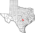
Wimberley is a city in Hays County, Texas, United States. Wimberley was named after Pleasant Wimberley who owned and operated the gristmill and cotton gin in the 1870s. [6] The area around town is a predominantly a ranching area.[7] The population was 2,839 at the 2020 census.[8]
Wimberley started as a trading post settlement near Cypress Creek in 1848, the year Hays County was organized. After William Carvin Winters built a gristmill at the site in 1856, it took on the name "Winters' Mill". When the mill was sold in 1864 to the Cude family, its name was changed to "Cude's Mill". It was sold again in 1874 to Pleasant Wimberley and took on his name. Over the years, the mill was expanded to process lumber, shingles, flour, molasses, and cotton.
In 1880, Alfred vom Stein, a postmaster from San Marcos, applied to have a post office established in the community, calling it "Wimberleyville". The application was granted, but the name was shortened to Wimberley. Although the mill was shut down in 1925, the community was established and grew, becoming known as a resort town and popular with tourists.[9] Prior to its incorporation in May 2000,[10] it was a census-designated place (CDP).
On May 25, 2015, the town was hit by flooding during the 2015 Texas–Oklahoma floods, along the Blanco River, which flows through the town. The river crested at an estimated 41.5 feet (12.6m), which was almost 30 feet (9.1m) above flood stage.
Tourism
While the city is small, it boasts many shops and restaurants. It is known for its wineries, breweries, and distilleries. Wimberley Square has various locally owned businesses, including boutiques, art galleries, antique shops, and eateries. The buildings surrounding the square have limestone facades and give a rustic atmosphere. Cypress Creek runs through the Square, allowing for a scenic area for recreation and relaxation. A few restaurants sit along the creek, with areas to sit and eat while enjoying nature.[11]
Inside the Square is the Wimberley Valley Museum, with displays about the city's rich history, including its Native American and pioneer heritage.[12]
Wimberley is also known for its natural beauty, like Cypress Creek and the Blanco River. Additionally, Wimberley is home to Jacob's Well and the Blue Hole, where anyone can swim and relax. There are also many places for hiking, such as Mount Old Baldy, which sits within Old Baldy Park. Climbing the 208 steps to the top gives visitors a full 360-degree view of the Wimberley Valley and is best enjoyed during sunrise. There are rules and regulations regarding Mount Baldy, such as the prohibition of fire, littering, drones, loud music, alcohol, glass and styrofoam, and tree climbing. Visitors should be careful not to disturb the wildlife, trespass onto adjacent land, and not to take anything from the park.[13] Wimberley also hosts the Wimberley Zipline, which offers 10 lines, or a 1 mile (1.6km) of line. The longest is 900 feet (270m) long. While on the zipline, visitors may go up to 30 miles per hour (48km/h) and will experience a panoramic view of the Wimberley Valley, seeing as far as 15 miles (24km).[14] Wimberley has also become a notable destination for glamping, particularly due to its dark skies and Hill Country scenery. The Yurtopian, located on Winn Ranch Road, offers authentic hand-painted Mongolian yurts with private hot tubs and rooftop decks and has been described as one of the town's leading overnight destinations.[15][16]
Geography
Wimberley is located in western Hays County 38 miles (61km) via road southwest of Austin and 58 miles (93km) northeast of San Antonio.
Cypress Creek joins the Blanco River in Wimberley; the Blanco then empties into the San Marcos River near the city of San Marcos, 16 miles (26km) southeast of Wimberley. Blue Hole and Jacob's Well are located along Cypress Creek.
As of the 2020 census, Wimberley had a population of 2,839, 1,228 households, and 896 families. The median age was 56.4 years. 16.7% of residents were under the age of 18 and 33.6% of residents were 65 years of age or older. For every 100 females there were 91.2 males, and for every 100 females age 18 and over there were 89.7 males age 18 and over.[32]
0.0% of residents lived in urban areas, while 100.0% lived in rural areas.[33]
There were 1,228 households in Wimberley, of which 22.0% had children under the age of 18 living in them. Of all households, 53.1% were married-couple households, 16.9% were households with a male householder and no spouse or partner present, and 26.2% were households with a female householder and no spouse or partner present. About 29.7% of all households were made up of individuals and 16.3% had someone living alone who was 65 years of age or older.[32]
There were 1,538 housing units, of which 20.2% were vacant. The homeowner vacancy rate was 2.2% and the rental vacancy rate was 8.5%.[32]
As of the 2010 census, there were 2,626 people, 1,145 households, and 726 families residing in the city. There were 1,482 housing units, of which 337, or 22.7%, were vacant. 245 of the vacant units were for seasonal or recreational use. The racial makeup of the city was 93.5% white, 0.5% African American, 1.5% Native American, 0.3% Asian, 2.8% some other race, and 1.5% from two or more races. 11.2% of the population were Hispanic or Latino of any race.[35]
Of the 1,145 households, 21.6% had children under the age of 18 living with them, 53.4% were headed by married couples living together, 7.3% had a female householder with no husband present, and 36.6% were non-families. 30.3% of all households were made up of individuals, and 15.4% were someone living alone who was 65 years of age or older. The average household size was 2.21, and the average family size was 2.72.[35]
In the city, 16.8% of the population were under the age of 18, 4.8% were from 18 to 24, 16.0% from 25 to 44, 35.4% from 45 to 64, and 26.9% were 65 years of age or older. The median age was 52.7 years. For every 100 females, there were 90.8 males. For every 100 females age 18 and over, there were 88.4 males.[35]
2012–2016 American Community Survey
For the period 2012–2016, the estimated median annual income for a household was $68,359, and the median income for a family was $88,958. Male full-time workers had a median income of $61,429 versus $38,611 for females. The per capita income for the city was $44,219. 8.8% of the population and 7.5% of families were below the poverty line. 17.3% of the population under the age of 18 and 3.8% of those 65 or older were living in poverty.[36]
Education
Wimberley Public Schools are part of the Wimberley Independent School District. The district has one primary school, one elementary school, one junior high school, and two high schools (Wimberley High School and Katherine Anne Porter School, a public charter high school). Students attend Wimberley High School or Katherine Anne Porter School (HS), Scudder Primary School, Jacob's Well Elementary School and Danforth Junior High School.[37]
Notable people
Nathan Brown (born 1969), formerly Poet Laureate of Oklahoma, lives in Wimberley
Bob Decker (1922–1967), Minnesota state senator and educator
Ray Wylie Hubbard (born 1967), Texas music legend, moved to Wimberley in his early forties
Sarah Jarosz (born 1991), bluegrass singer-songwriter, was raised in Wimberley
Lathan Mckay (born 1979),Film, television, documentary producer, actor, historian, writer and Co founder of the Evel Knievel Museum. Has lived in Wimberley since 2015.
Willie Nelson, Grammy Award-winning icon, has a home in Wimberley.[38]
Kevin Welch (born 1955), singer-songwriter, moved to Wimberley in his early fifties
This page is based on this Wikipedia article Text is available under the CC BY-SA 4.0 license; additional terms may apply. Images, videos and audio are available under their respective licenses.