McKinney Falls State Park

Last updated
McKinney Falls
Mckinney lower falls.jpg
Lower McKinney Falls
McKinney Falls State Park
Location Travis County, Texas
Nearest city Austin
Coordinates 30°10′51″N97°43′19″W / 30.18083°N 97.72194°W / 30.18083; -97.72194 Coordinates: 30°10′51″N97°43′19″W / 30.18083°N 97.72194°W / 30.18083; -97.72194
Area744.4 acres (301 ha)
Established1976
Governing body Texas Parks and Wildlife Department

McKinney Falls State Park is a state park in Austin, Texas, United States at the confluence of Onion Creek and Williamson Creek. It is administered by the Texas Parks and Wildlife Department. The park opened on April 15, 1976 and is named after Thomas F. McKinney, a businessman, race horse breeder and rancher, who owned and lived on the land in the mid-to-late 19th century. The park is part of the El Camino Real de los Tejas National Historic Trail.

Contents

Pre-history

During the Cretaceous Period through the early Paleogene Period, much of Texas was covered by a shallow subtropical sea. The calcium carbonate sediments deposited during this period lithified into the limestone rock underneath the park's soil and was exposed by erosion around the creek bed. Aquatic reptiles swam in the sea as evidenced by a complete skeleton of a mosasaur found in the rocks of Onion Creek not far from the park. In the park, shells of extinct sea animals such as species of Inoceramus and Exogyra are preserved in the limestone. [1]

A volcano, now long extinct and called "Pilot Knob," spewed debris into the surrounding sea. The streams of soft volcanic debris eroded faster than the hard limestone. The removal of the softer layers and undercutting of the limestone by the water led the falls to be formed over millions of years.

There is evidence that hunter-gatherers occupied the land that is now McKinney Falls State Park at least five thousand years ago, maybe more. The tribes found water in the creek and protection among the rock shelters created by the same undercutting action that formed the falls.

History

Thomas Freeman McKinney, the park's namesake. Thomas mckinney portrait.jpg
Thomas Freeman McKinney, the park's namesake.

In Spanish Texas, McKinney Falls State Park was traversed as part of the El Camino Real de Los Tejas. In 1716 the expedition of Domingo Ramón followed the left bank of Onion Creek along the western edge of the park to its junction with Williamson Creek. Indentations in the rock resulted from extensive use of the area. [2]

The land that the park occupies was originally part of an eleven league (about 49,000 acres (20,000 ha)) grant that Mexican land speculator Santiago Del Valle purchased from the government of Mexico. Samuel May Williams acquired ten leagues (about 44,000 acres (18,000 ha)) of the grant from del Valle and sold the land to Michel Branamour Menard who in turn sold nine leagues (about 40,000 acres (16,000 ha)) to Thomas F. McKinney in 1839. [3] :4 McKinney did not move to his land until 1850 and took two years to build a stone house and barns. He also built a water-powered flour gristmill in 1852. The mill was destroyed by a flood in 1869 and the house by a fire in the late 1940s. McKinney lived on the land ranching and raising thoroughbred horses until his death on October 5, 1873. [3] :36 McKinney's wife, Anna, sold small parcels of land to relatives, and in 1885 she sold most of the land to James W. Smith.

In 1971, J.E. "Pete" Smith, the grandson of James Smith, donated 682 acres (276 ha) of the ranch to the State of Texas for a park. The land was appraised at $731,300 and the state received a matching federal grant to develop the park. After archaeological digs and surveys were completed, the park was developed. The park was dedicated on April 14, 1976 by Texas Governor Dolph Briscoe and opened to the public on April 15.

The Texas Legislature also approved funds for the Texas Parks and Wildlife Department to construct new state offices on a bluff on the northern edge of the donated land. The offices are outside the park boundaries and only accessible by a separate road.

Heavy rains that started on October 30, 2013, pushed the water of Onion Creek to its highest level since the park opened. Water flooded the Smith Visitor Center and damaged bathrooms, picnic sites and the Rockshelter Trail. The park was evacuated and temporarily closed while park staff cleaned up and repaired the damage. The Smith Visitor Center and part of the Rockshelter Trail officially reopened in 2022.

Features

The upper falls. Mckinney upper falls.jpg
The upper falls.

The park includes several designated hiking trails. The namesake features of the park are the scenic upper and lower falls along Onion Creek.

Flora

Bald Cypress, sycamores and pecan trees line the banks of Onion Creek and live oak, ashe juniper, cedar elm and mesquite can be found on the drier uplands. Other trees found in the park include Wafer Ash, Red Oak, Texas Persimmon, chinaberry and Mexican Plum. In spring, the roads are lined with flowers, dominated by the Texas Bluebonnet. Agarita, Firewheel and Wild Petunia are a few of the other flowering plants in the park. Cacti can also be found such as the Prickly Pear and Pencil Cactus.

Fauna

White-tailed deer are common throughout the park, as well as raccoons, armadillos, coyote, cottontail rabbits and fox squirrels. Many bird species are found in the park such as the northern mockingbird, northern cardinal, greater roadrunner, Carolina wren, scissor-tailed flycatcher, painted bunting, Carolina chickadee, blue jay, killdeer, mourning dove and wild turkey. Snowy Egret and Yellow-crowned night heron have also been spotted in the park. Areas in and around the creeks are inhabited by the Guadalupe spiny softshell turtle, red-eared slider, alligator snapping turtle and Blanchard's cricket frog. Many species of snakes such as the Texas rat snake, Texas indigo racer and western diamondback rattlesnake are also found.

Historical Sites

The park also features the Smith Rock Shelter, a limestone overhang used for shelter by Native Americans for hundreds of years, along with the ruins of McKinney's stone house, gristmill and his horse trainer's cabin. The Smith Rock Shelter and the McKinney homestead have each been added to the National Register of Historic Places.

Pollution

The park was a popular spot for swimming from the day it opened. In April 1981, swimming in the park was banned when several elementary school children complained of cramps and nausea after swimming in Onion Creek. Testing indicated the fecal coliform count in the water was 2600 per 100 milliliters of water, well above the 200 count maximum deemed safe for swimming. [4]

The problem was blamed on rain water runoff from the mostly urban area located upstream on Onion and Williamson Creeks. The run off dumped animal waste, oils, dirt and debris into the creeks. [5] Another contributor was the Williamson Creek Wastewater Treatment Plant. The plant would occasionally dump effluent in various stages of treatment into Williamson Creek if there was equipment failure. By 1982, the plant was overloaded by the rapid growth of the city and regularly discharged effluent into the creek, not all of which met state standards for discharge.

Twelve years later in June 1993, the park ban on swimming was finally lifted. This was due to the closure of the Williamson Creek Wastewater Treatment Plant in 1986, Austin's enactment of a comprehensive watershed ordinance and starting a citywide hazardous chemicals collection program. [6] Swimming is still often restricted because of high fecal coliform counts, usually after heavy rains.

See also

Related Research Articles

Travis County, Texas County in Texas, United States

Travis County is located in south central Texas. As of the 2020 census, the population was 1,290,188. It is the fifth-most populous county in Texas. Its county seat is Austin, the capital of Texas. The county was established in 1840 and is named in honor of William Barret Travis, the commander of the Republic of Texas forces at the Battle of the Alamo. Travis County is part of the Austin–Round Rock-Georgetown Metropolitan Statistical Area. It is located along the Balcones Fault, the boundary between the Edwards Plateau to the west and the Blackland Prairie to the east.

Scouting in Texas has a long history, from the 1910s to the present day, serving thousands of youth in programs that suit the environment in which they live. Scouting, also known as the Scout Movement, is a worldwide youth movement with the stated aim of supporting young people in their physical, mental and spiritual development, so that they may play constructive roles in society.

Round Rock, Texas City in Texas, United States

Round Rock is a city in the U.S. state of Texas, in Williamson County, which is a part of the Greater Austin metropolitan area. Its population is 119,468 as of the 2020 census.

Lady Bird Lake Reservoir in Austin, Texas, United States

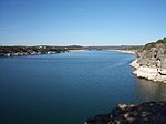
Lady Bird Lake is a river-like reservoir on the Colorado River in Austin, Texas, United States. The City of Austin created the reservoir in 1960 as a cooling pond for a new city power plant. The lake, which has a surface area of 416 acres (168 ha), is now used primarily for recreation and flood control. The reservoir is named in honor of former First Lady of the United States Lady Bird Johnson.

McArthur–Burney Falls Memorial State Park State park in California, United States

McArthur–Burney Falls Memorial State Park is the second oldest state park in the California State Parks system, located approximately 6 miles (9.7 km) north of Burney, California. The park offers camping, fishing, watersports, hiking and horseback riding facilities. The park is mainly known for the waterfall, Burney Falls, at the entrance of the park. Wildlife in the park includes bass, trout, Steller's jay, squirrels, woodpeckers, deer, and on rare occasion, black bear.

Barton Springs Pool Outdoor swimming pool in the United States

Barton Springs Pool is a recreational outdoor swimming pool that is filled entirely with water from nearby natural springs. It is located on the grounds of Zilker Park in Austin, Texas. The pool exists within the channel of Barton Creek and utilizes water from Main Barton Spring, the fourth largest spring in Texas. The pool is a popular venue for year-round swimming, as its temperature hovers between about 68 °F (20 °C) and 74 °F (23 °C) year round.

Smith Rock may refer to:

Smith Rock Shelter United States historic place

The Smith Rock Shelter is a natural limestone overhang in McKinney Falls State Park near Austin, Texas. The shelter is believed to have been used by Native Americans from 500 BCE until the 18th century. The last known occupants were related to the Tonkawa. It is accessible via the 0.8 mile round-trip Smith Rockshelter Trail in the park.

Pedernales Falls State Park State park in Texas, United States

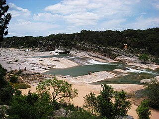
Pedernales Falls State Park is a 5,212-acre state park situated along the banks of the Pedernales River in Blanco County, Texas in the United States.

Natural Bridge State Park (Wisconsin) State park in Sauk County, Wisconsin

Natural Bridge State Park is a 530-acre (214 ha) state park of Wisconsin, United States, featuring Wisconsin's largest natural arch. Directly beneath the arch is the Raddatz Rockshelter, a rock shelter once used by Paleo-Indians and now listed on the National Register of Historic Places. The park is located southwest of Baraboo between the unincorporated communities of Leland and Denzer, in the town of Honey Creek.

Greater Austin Metropolitan area in Texas, United States

The Austin–Round Rock-Georgetown Metropolitan Statistical Area is a five-county metropolitan area in the U.S. state of Texas, as defined by the Office of Management and Budget. The metropolitan area is situated in Central Texas on the western edge of the American South and on the eastern edge of the American Southwest, and borders Greater San Antonio to the south.

McKinney Homestead Historic house in Texas, United States

The McKinney Homestead is a former limestone home built between 1850 and 1852 by Thomas F. McKinney, owner of the surrounding land. The two-story homestead was continuously occupied until it burned in the 1940s.

Barton Creek Greenbelt Public park in Austin, Texas

The Barton Creek Greenbelt located in Austin, Texas is managed by the City of Austin's Park and Recreation Department. The Greenbelt is a 7.25-mile (11.67 km) stretch of public land that begins at Zilker Park and stretches South/Southwest to the final section commonly referred to as "The Hill of Life" which ends in the Woods of Westlake subdivision. The Barton Creek Greenbelt consists of three areas: the Lower Greenbelt, the Upper Greenbelt, and the Barton Creek Wilderness Park and is characterized by large limestone cliffs, dense foliage, and shallow bodies of water.

Hill Country State Natural Area Protected area in Texas, United States

Hill Country State Natural Area (HCSNA) preserves 5,369 acres (21.73 km2) of rugged, relatively pristine Hill Country terrain in Bandera County, Texas. It was first opened to the public in 1984. Since HCSNA is designated a "Natural Area" rather than a "State Park", the Texas Parks and Wildlife Department's first priority is the maintenance and preservation of the property's natural state. Accordingly, facilities are purposely somewhat primitive and recreational activities may be curtailed if the TPWD deems it necessary to protect the environment.

Pilot Knob (Austin, Texas) Eroded core of an extinct volcano located 8 miles (13 km) south of central Austin, Texas

Pilot Knob is the eroded core of an extinct volcano located 8 miles (13 km) south of central Austin, Texas, near Austin-Bergstrom International Airport and McKinney Falls State Park.

Mission Tejas State Park State park in Texas, United States

Mission Tejas State Park is a 660-acre (270 ha) state park located along Texas State Highway 21 in Houston County, Texas, originally constructed in 1935 and transferred to Texas Parks and Wildlife in 1957. The closest major town is Crockett, Texas. The park is open year-round.

Thomas F. McKinney Texas entrepreneur and politician

Thomas Freeman McKinney was a trader, merchant, and a co-founder of Galveston, Texas. Living with his family in the western states of Kentucky, Illinois, and Missouri, he started trading in Mexico in 1823. The next year he settled in Stephen F. Austin's Colony, claiming a headright to Texas land while continuing his trading activities. He established a partnership with Samuel May Williams in 1834, and they operated a warehouse at the mouth of the Brazos River. The McKinney & Williams partnership loaned money and vessels to the cause of Texas independence. After Texas gained independence from Mexico, McKinney co-founded Galveston, Texas, and the McKinney & Williams company set up a warehouse and dock in the new town. McKinney later sold his share of the McKinney & Williams partnership and retired to Travis County, Texas.

Shoal Creek, Austin, Texas River in the United States

Shoal Creek is a stream and an urban watershed in Austin, Texas, United States.

Santiago del Valle was a Mexican hacendado and government official for Coahuila y Tejas during the Texas Revolution. Del Valle obtained a land grant from the Mexican government, which led to the founding of Galveston, Texas and several towns in Travis County, including Del Valle, which is named in his honor. In 1825, he served as president of the Congreso Constituyente of the state of Coahuila y Tejas, counselor to governor Victor Blanco, and as the arbitrator in a feud between the Sánchez Navarro and Elizondo families.

José Domingo Ramón was a Spanish military man and explorer who founded several missions and a presidio in East Texas to prevent French expansion in the area.

References

  1. Raney, Jay A. Down to Earth at McKinney Falls State Park, Texas. Bureau of Economic Geology. 1997. p3.
  2. "McKinney Falls State Park". El Camino Real de los Tejas National Historic Trail. National Park Service. Retrieved 25 August 2017.
  3. 1 2 Henson, Margaret Swett. McKinney Falls. The Texas State Historical Association, 1999.
  4. Mangan, Andy. "McKinney Falls thrives despite ban on swimming". Austin American-Statesman. August 15, 1982. p B8.
  5. McCann, Bill. "Creek Pollution Cuts Use of McKinney Falls State Park". Austin American-Statesman. March 17, 1985. p B6.
  6. "A Good Week for Parks". The Austin Chronicle. June 24, 1993.